Lorn property fact sheet
•
0 likes•594 views

Very large altered and mineralized porphyry copper-molybdenum-silver system adjacent to the recent major BC discovery, the IKE.

Recommended
Recommended
More Related Content
What's hot
What's hot (20)
Viewers also liked
Viewers also liked (20)
Similar to Lorn property fact sheet
Similar to Lorn property fact sheet (20)
More from John Chapman
More from John Chapman (9)
Recently uploaded
Recently uploaded (20)
Lorn property fact sheet
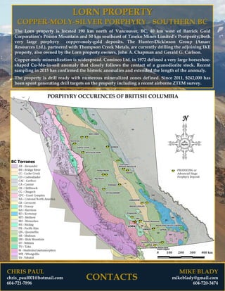
- 1. CHRIS PAUL chris_paul001@hotmail.com 604-721-7896 CONTACTS MIKE BLADY mikeblady@gmail.com 604-720-3474 LORN PROPERTY COPPER-MOLY-SILVER PORPHYRY - SOUTHERN BC The Lorn property is located 190 km north of Vancouver, BC, 40 km west of Barrick Gold Corporation’s Poison Mountain and 50 km southeast of Taseko Mines Limited’s Prosperity, both very large porphyry copper-moly-gold deposits. The Hunter-Dickinson Group (Amarc Resources Ltd.), partnered with Thompson Creek Metals, are currently drilling the adjoining IKE property, also owned by the Lorn property owners, John A. Chapman and Gerald G. Carlson. Copper-moly mineralization is widespread. Cominco Ltd. in 1972 defined a very large horseshoe- shaped Cu-Mo-in-soil anomaly that closely follows the contact of a granodiorite stock. Recent sampling in 2015 has confirmed the historic anomalies and extended the length of the anomaly. The property is drill ready with numerous mineralized zones defined. Since 2011, $242,000 has been spent generating drill targets on the property including a recent airborne ZTEM survey.
- 2. CHRIS PAUL chris_paul001@hotmail.com 604-721-7896 CONTACTS MIKE BLADY mikeblady@gmail.com 604-720-3474 LOCATION AND PHYSIOGRAPHY The property is located in Southern British Columbia, at 51°06’05” N latitude and 123°12’49” W longitude on NTS map sheet 92O/03. The property lies 190 km north of Vancouver and 30 km ESE of the south end of Lower Taseko Lake. The majority of the property lies above timberline, which is at approximately 2000 meters. Loose talus grades with increasing altitude into steep outcrop bluffs. Elevations range from 1,950 meters to over 2,900 meters. Seasonal exploration surveys can commence from about late June and normally end by mid October. ACCESS Property access is from Pemberton, Williams Lake, Gold Bridge or King Ranch by fixed-wing float plane aircraft to a camp on Lorna Lake or by helicopter. CLAIMS The property is comprised of 9 mineral tenures covering a total area of 3,957 hectares, owned 25% by John A. Chapman, 25% by Gerald G. Carlson, and 50% by Christopher R. Paul.
- 3. CHRIS PAUL chris_paul001@hotmail.com 604-721-7896 CONTACTS MIKE BLADY mikeblady@gmail.com 604-720-3474 EXPLORATION HISTORY • 1963: Phelps Dodge Corporation discovered copper and molybdenum mineralization as part of a regional mineral exploration program – no records of their work are available. • 1969: Burlington Mines Ltd. prospected and trenched the main mineral showings. • 1971 to 1974: Cominco Ltd. outlined a very large, horseshoe-shaped Cu-Mo geochemical anomaly in soil samples collected from the headwaters of Big Creek. The anomaly closely follows the contact of a granodiorite stock and surrounding volcanics. Cominco drilled five short core holes from two setups and intersected mineralization in all 5 holes. • 1982: Barrier Reef Resources Ltd. identified strong epithermal style alteration on the ridge NW of Sluice Creek and followed up with soil sampling downslope of the altered outcrops. This work uncovered anomalous silver and gold values on an 060o trend following the ridge for over 1 km. • 2011 to 2013 Royal Sapphire Corp conducted $212,000 in mineral exploration including an airborne ZTEM survey (Geotech Ltd.), mapping and sampling. Several mineralized targets have been located on the Property. • 2015: Jet Gold Corp conducted talus-fines sampling and extended Cominco’s historic horseshoe- shaped Cu-Mo geochemical anomaly westward into Sluice Creek Valley.
- 4. CHRIS PAUL chris_paul001@hotmail.com 604-721-7896 CONTACTS MIKE BLADY mikeblady@gmail.com 604-720-3474 GEOLOGY The main lithology throughout the Property is the Upper Cretaceous Powell Creek Formation (Kingsvale Group) of volcanic and volcaniclastic rocks. Adjacent to the contact with the Lorna Stock, the volcanic rocks are hornfelsed and contain pyrite, with lesser amounts of pyrrhotite and chalcopyrite. The pyrite content often exceeds several percent, imparting a bright reddish gossan locally along the contact. The Dorrie Peak and Lorna Lake Stocks intrude the Powell Creek Fm rocks. The Dorrie Peak diorite, occurring in the northwest portion of the property, gives an absolute age date of approximately 65 Ma and is genetically related to the Upper Cretaceous Powell Creek Formation volcanics. The Lorna Lake stock is dated at 42 Ma and occurs in the east portion of the claim block, centered along Big Creek. The intrusion varies from fine to coarse grain size and is locally porphyritic along contact zones. In its core, the intrusion is fresh, while towards the contacts it becomes more highly altered. The ridge north of Sluice Creek contains ubiquitous pyrite, extensive hydrated iron oxides, and widespread silicification and argillic alteration in Kingsvale volcanics. A zone of vuggy, drusy, brecciated (epithermal) quartz with minor barite occurs on this ridge. Local occurrences of ferricrete, consisting of rounded to subangular boulders of volcanic and intrusive rocks cemented by iron oxide, occur down slope from occurrences of pyritic volcanic rocks.
- 5. CHRIS PAUL chris_paul001@hotmail.com 604-721-7896 CONTACTS MIKE BLADY mikeblady@gmail.com 604-720-3474 MINERALIZATION Cominco Ltd. in 1972 reported mineralization within the Lorna Stock consists of disseminated pyrite, chalcopyrite and pyrrhotite, with local molybdenite. The adjacent volcanic rocks contain disseminated and fracture controlled pyrite, pyrrhotite and local chalcopyrite mineralization. Copper mineralization is widespread. Reconnaissance soil sampling gave anomalous values (200 to 1,300 ppm Cu) along a 4 km strike length. Chip sampling (not continuous) from three separate areas within the intrusive returned 0.28% Cu over 2,120 ft. (647 m), including 1.17% Cu over 30 ft. (9.2 m) and 1.15% Cu over 200 ft. (61 m); 0.21% Cu over 1,660 ft. (506 m); and 0.40% Cu over 450 ft. (137 m). Allen and Heddle, authors of this 1972 technical report noted that these numbers are not representative, as they were from chip samples from discontinuous outcrop exposures. However, the authors indicated that they are a good qualitative guide to the mineralization present and that the zones were open along strike. Cominco Ltd. in their 1974 drilling report (five short holes from two setups) reported copper and molybdenum mineralization in all five holes. Cominco Ltd. (circa 1981) in follow up analyses for gold in soil samples from earlier (circa 1972) programs determined that many samples exceeded 10ppb gold with some over 100ppb gold. The highly epithermal altered ridge northwest of Sluice Creek also contains anomalous gold and silver in soils.
- 6. CHRIS PAUL chris_paul001@hotmail.com 604-721-7896 CONTACTS MIKE BLADY mikeblady@gmail.com 604-720-3474 EXPLORATION UPDATE With low copper and molybdenum prices for an extended period, the mineral claims over the discoveries were allowed to lapse and were subsequently acquired by John A. Chapman and KGE Management Ltd. (Gerald G. Carlson, Principal), the current owners. The property was optioned to Royal Sapphire in 2011 and an airborne ZTEM and magnetic survey was flown by Geotech Ltd. The ZTEM survey showed the core of the Lorna stock to have very low conductivities, with the contact and surrounding hornfels having much higher conductivities. This is in line with observations by Cominco geologists with regards to the contact zones being the most heavily mineralized. Outboard from this, the pyrite halo extends for a considerable distance in the hornfelsed aureole. Steep rocky bluffs prevented soil samples from being collected at higher elevations, with sampling restricted to their talus aprons. Downslope dispersion of geochemical anomalies therefore plays a significant role at the Lorn. The same airborne survey also highlighted magnetic low’s along the western contact of the stock which are coincident with the stronger Cu-Mo geochemistry. Similar mag low’s have been noted on the adjoining IKE property as important zones of magnetite destructive alteration which are coincident with the best grades. The high copper anomaly from the 2015 talus fines survey lies within a portion of a large mag low which is not covered by glacial outwash on the northwestern end of the Lorna stock contact.
- 7. CHRIS PAUL chris_paul001@hotmail.com 604-721-7896 CONTACTS MIKE BLADY mikeblady@gmail.com 604-720-3474 POTENTIAL The Lorn property is located on the eastern flank of the Coast Plutonic Complex within a NW-SE trend of porphyry copper-molybdenum-gold mineralization. To the northwest is Taseko Mines Limited’s Prosperity deposit reported to be the largest gold-copper deposit in Canada with reserves of 7.7 million ounces of gold and 3.6 billion pounds of copper and Amarc Resources Ltd.’s recent Newton gold discovery. Amarc is aggressively exploring a very large tract of land near the Lorn property in what it calls the “Plateau Gold-Copper Belt”. To the east is Barrick Gold Corporation’s Poison Mountain deposit with an estimated resource of 800 million tonnes grading 0.23% Cu, 0.12 g/t Au and 0.007% Mo. The Hunter Dickinson Group (Amarc Resources Ltd.) and Thompson Creek Metals are currently drilling the adjoining IKE property also owned by KGE/Chapman. They have recently reported a major porphyry copper-molybdenum-silver discovery at Ike. The Lorn copper-moly-gold occurrences have the potential for discovery of a large porphyry system similar to the Prosperity, IKE and Poison Mountain deposits. RECOMMENDATIONS The owners recommend the next phase of exploration should be diamond drilling of the targets outlined by recent work programs. OUTLOOK The Lorn porphyry copper-molybdenum-gold property has a current NI 43-101 technical report and is a TSX-v qualified property available for option, joint venture or purchase.