SlideShare a Scribd company logo
1 of 1
Download to read offline
USING MULTI-TEMPORAL SATELITE IMAGERYAND
MACHINE LEARNING TO PREDICT CROP TYPES IN
MIDDLE RIO GRANDE REGION
Habibur Howlider*, Saurav Kumar, Thomas Poulose, Deana Pennington
University of Texas at El Paso
*hrhowlider@miners.utep.edu
Introduction
Middle Rio Grande basin covers the watershed of the Rio Grande from
downstream of Elephant Butte (EB) reservoir to the entrance of the Rio
Conchos from Mexico. are the major crops grown in this watershed.
Deep learning (DL) is a powerful state-of-the-art technique for image
processing including multitemporal remote sensing (RS) images.
Although, pixel-based classification algorithms such as Random Forests
(RF) are widely used for cropland mapping but deep learning
classification using neural network are also becoming popular to find
better accuracy while classify the different crop types.
Objective
1.To understand crop type in the both cultivated and non-cultivated area
of the middle Rio Grande Region by classifying area under five main
crops (Cotton, pecan, onion, pepper and alfalfa) using multi-temporal
satellite imagery.
2. To predict and find highest overall accuracy for crop type classification
by using supervised classification algorithm (Random Forest) and deep
learning (Convolutional Neural Network).
Methodology
1. Classification
Features (134 Bands):
 Landsat bands monthly cloud free median (7 x 12 = 84) 30m
 Monthly NDVI (12) 30m
Monthly CRSI (12) 30m
 Global elevation (1) 90m
 Global slope (1) 90m
 Global monthly ET (12) 1000m
 Elephant Bute monthly flows (12)
Targets:
Cultivated / Uncultivated 2017
Crop Type 2017
2. Supervised Classification with Convolutional Neural Networks
Four-level architecture proposed for classification of crop types from
multitemporal satellite imagery.
Level I : Preprocessing
Level II: Supervised Classification
Level III: Postprocessing
Level IV: Geospatial Analysis
Model Workflow
Discussion
For random forest classification using Google Earth Engine, validation
overall accuracy for cultivation/non cultivation was found 94% where
validation accuracy was 73%. Deep learning classification using
convolutional neural network can be added to the predictive model for
increasing the validation accuracy for each dataset.
NDVI =
Landsat 7 Bands
NDVI
CRSI
Elevation
Slope
ET
Monthly Flows
Random
Forest
Classifier
2017 Dataset
All Data
2001 - 2017
Crop Type Area > 2500 acres
Crop Type
Cultivated / Not
Cultivated
Target
Masking
Random
Forest
Classifier
Fig 2 . 3-D CNN Architecture for classification of crop types from
multitemporal satellite imagery
Fig 1. Middle Rio Grande Basin
),( ,,,
000
bnwy nkejdickcde xij
M
j
M
i
N
kn
 
 

Equation for 3D Convolution for Multi-temporal Multi-Spectral
Images:
where wkij is a 3D tensor, k is the temporal indicator and N is its length, n
indicates n-th feature map of previous layer, xcde and ycde are the input and
output activation at location (c, d, e), respectively.
Fig 3: Model workflow of crop classification by a) supervised classification
algorithm (Random Forest) and b) Deep Learning (Convolutional Neural
Network) using Landsat 7 Satellite Imagery
Study
Area
CRSI =
a
b

More Related Content

What's hot

Community ecology lab
Community ecology labCommunity ecology lab
Community ecology labjamisona
 
Gis n gps in nematode
Gis n gps in nematodeGis n gps in nematode
Gis n gps in nematodeNageshb11
 
Population Projection of Bald Eagles
Population Projection of Bald EaglesPopulation Projection of Bald Eagles
Population Projection of Bald Eagleskpotterf
 
Geospatial Techniques for Measuring SI Assessment Indicators
Geospatial Techniques for Measuring SI Assessment IndicatorsGeospatial Techniques for Measuring SI Assessment Indicators
Geospatial Techniques for Measuring SI Assessment Indicatorsafrica-rising
 
Spatial Statistics 2017 Conference: Towards the modelling and mapping of acti...
Spatial Statistics 2017 Conference: Towards the modelling and mapping of acti...Spatial Statistics 2017 Conference: Towards the modelling and mapping of acti...
Spatial Statistics 2017 Conference: Towards the modelling and mapping of acti...Irene Garcia-Marti
 
MediaEval 2017 - Satellite Task: Data-Driven Flood Detection using Neural Net...
MediaEval 2017 - Satellite Task: Data-Driven Flood Detection using Neural Net...MediaEval 2017 - Satellite Task: Data-Driven Flood Detection using Neural Net...
MediaEval 2017 - Satellite Task: Data-Driven Flood Detection using Neural Net...multimediaeval
 
Diversification in Australian broadacre farming: can simulation models handle...
Diversification in Australian broadacre farming: can simulation models handle...Diversification in Australian broadacre farming: can simulation models handle...
Diversification in Australian broadacre farming: can simulation models handle...Joanna Hicks
 
Luo-IGARSS2011-2385.ppt
Luo-IGARSS2011-2385.pptLuo-IGARSS2011-2385.ppt
Luo-IGARSS2011-2385.pptgrssieee
 
Self-organzing maps in Earth Observation Data Cube Analysis
Self-organzing maps in Earth Observation Data Cube AnalysisSelf-organzing maps in Earth Observation Data Cube Analysis
Self-organzing maps in Earth Observation Data Cube AnalysisLorena Santos
 
Geographical Information System
Geographical Information SystemGeographical Information System
Geographical Information SystemDevegowda S R
 
C.C.A.F.S. “Agricultural and Land-use Databases for Climate Smart Agriculture.”
C.C.A.F.S. “Agricultural and Land-use Databases for Climate Smart Agriculture.”C.C.A.F.S. “Agricultural and Land-use Databases for Climate Smart Agriculture.”
C.C.A.F.S. “Agricultural and Land-use Databases for Climate Smart Agriculture.”World Agroforestry (ICRAF)
 
Use Case: PostGIS and Agribotics
Use Case: PostGIS and AgriboticsUse Case: PostGIS and Agribotics
Use Case: PostGIS and AgriboticsPGConf APAC
 
IAOS 2018 - Satellite imagery analysis for Sustainable Development Goals: req...
IAOS 2018 - Satellite imagery analysis for Sustainable Development Goals: req...IAOS 2018 - Satellite imagery analysis for Sustainable Development Goals: req...
IAOS 2018 - Satellite imagery analysis for Sustainable Development Goals: req...StatsCommunications
 
Characterizing Forest Degradation using Multiple SAR Approaches
Characterizing Forest Degradation using Multiple SAR ApproachesCharacterizing Forest Degradation using Multiple SAR Approaches
Characterizing Forest Degradation using Multiple SAR ApproachesCIFOR-ICRAF
 
Use of Drone for Efficient Water Management – A Case Study of Crop Assessment
Use of Drone for Efficient Water Management – A Case Study of Crop AssessmentUse of Drone for Efficient Water Management – A Case Study of Crop Assessment
Use of Drone for Efficient Water Management – A Case Study of Crop Assessmentpravinkolhe
 

What's hot (19)

Community ecology lab
Community ecology labCommunity ecology lab
Community ecology lab
 
Gis n gps in nematode
Gis n gps in nematodeGis n gps in nematode
Gis n gps in nematode
 
Population Projection of Bald Eagles
Population Projection of Bald EaglesPopulation Projection of Bald Eagles
Population Projection of Bald Eagles
 
Geospatial Techniques for Measuring SI Assessment Indicators
Geospatial Techniques for Measuring SI Assessment IndicatorsGeospatial Techniques for Measuring SI Assessment Indicators
Geospatial Techniques for Measuring SI Assessment Indicators
 
Spatial Statistics 2017 Conference: Towards the modelling and mapping of acti...
Spatial Statistics 2017 Conference: Towards the modelling and mapping of acti...Spatial Statistics 2017 Conference: Towards the modelling and mapping of acti...
Spatial Statistics 2017 Conference: Towards the modelling and mapping of acti...
 
MediaEval 2017 - Satellite Task: Data-Driven Flood Detection using Neural Net...
MediaEval 2017 - Satellite Task: Data-Driven Flood Detection using Neural Net...MediaEval 2017 - Satellite Task: Data-Driven Flood Detection using Neural Net...
MediaEval 2017 - Satellite Task: Data-Driven Flood Detection using Neural Net...
 
Grower Presentation 3
Grower Presentation 3Grower Presentation 3
Grower Presentation 3
 
Diversification in Australian broadacre farming: can simulation models handle...
Diversification in Australian broadacre farming: can simulation models handle...Diversification in Australian broadacre farming: can simulation models handle...
Diversification in Australian broadacre farming: can simulation models handle...
 
The Potential of Big Data
The Potential of Big DataThe Potential of Big Data
The Potential of Big Data
 
Day1_Theme3_Timothy J. Krupnik
Day1_Theme3_Timothy J. KrupnikDay1_Theme3_Timothy J. Krupnik
Day1_Theme3_Timothy J. Krupnik
 
Sonti's Article
Sonti's ArticleSonti's Article
Sonti's Article
 
Luo-IGARSS2011-2385.ppt
Luo-IGARSS2011-2385.pptLuo-IGARSS2011-2385.ppt
Luo-IGARSS2011-2385.ppt
 
Self-organzing maps in Earth Observation Data Cube Analysis
Self-organzing maps in Earth Observation Data Cube AnalysisSelf-organzing maps in Earth Observation Data Cube Analysis
Self-organzing maps in Earth Observation Data Cube Analysis
 
Geographical Information System
Geographical Information SystemGeographical Information System
Geographical Information System
 
C.C.A.F.S. “Agricultural and Land-use Databases for Climate Smart Agriculture.”
C.C.A.F.S. “Agricultural and Land-use Databases for Climate Smart Agriculture.”C.C.A.F.S. “Agricultural and Land-use Databases for Climate Smart Agriculture.”
C.C.A.F.S. “Agricultural and Land-use Databases for Climate Smart Agriculture.”
 
Use Case: PostGIS and Agribotics
Use Case: PostGIS and AgriboticsUse Case: PostGIS and Agribotics
Use Case: PostGIS and Agribotics
 
IAOS 2018 - Satellite imagery analysis for Sustainable Development Goals: req...
IAOS 2018 - Satellite imagery analysis for Sustainable Development Goals: req...IAOS 2018 - Satellite imagery analysis for Sustainable Development Goals: req...
IAOS 2018 - Satellite imagery analysis for Sustainable Development Goals: req...
 
Characterizing Forest Degradation using Multiple SAR Approaches
Characterizing Forest Degradation using Multiple SAR ApproachesCharacterizing Forest Degradation using Multiple SAR Approaches
Characterizing Forest Degradation using Multiple SAR Approaches
 
Use of Drone for Efficient Water Management – A Case Study of Crop Assessment
Use of Drone for Efficient Water Management – A Case Study of Crop AssessmentUse of Drone for Efficient Water Management – A Case Study of Crop Assessment
Use of Drone for Efficient Water Management – A Case Study of Crop Assessment
 

Similar to Habibur%20 poster%20(3)(1)

AGRICULTURE INFORMATION SYSTEM USING REMOTE SENSING, GEOGRAPHICAL ANALYSIS ...
AGRICULTURE INFORMATION SYSTEM USING  REMOTE SENSING, GEOGRAPHICAL  ANALYSIS ...AGRICULTURE INFORMATION SYSTEM USING  REMOTE SENSING, GEOGRAPHICAL  ANALYSIS ...
AGRICULTURE INFORMATION SYSTEM USING REMOTE SENSING, GEOGRAPHICAL ANALYSIS ...Alok Singh
 
Online freely available remote sensed data
Online freely available remote sensed dataOnline freely available remote sensed data
Online freely available remote sensed dataDhaval Jalalpara
 
Integrating local crowdsourced and remotely sensed data to characterize range...
Integrating local crowdsourced and remotely sensed data to characterize range...Integrating local crowdsourced and remotely sensed data to characterize range...
Integrating local crowdsourced and remotely sensed data to characterize range...ILRI
 
Applications of Remote Sensing
Applications of Remote SensingApplications of Remote Sensing
Applications of Remote SensingAbhiram Kanigolla
 
IABIN Threat Assessment Project Presentation (Costa Rica) by Andy Jarvis from...
IABIN Threat Assessment Project Presentation (Costa Rica) by Andy Jarvis from...IABIN Threat Assessment Project Presentation (Costa Rica) by Andy Jarvis from...
IABIN Threat Assessment Project Presentation (Costa Rica) by Andy Jarvis from...Hector
 
RPG iEvoBio 2010 Keynote
RPG iEvoBio 2010 KeynoteRPG iEvoBio 2010 Keynote
RPG iEvoBio 2010 KeynoteRob Guralnick
 
iEvoBio Keynote Talk 2010
iEvoBio Keynote Talk 2010iEvoBio Keynote Talk 2010
iEvoBio Keynote Talk 2010Rob Guralnick
 
Remotesensing 11-00164
Remotesensing 11-00164Remotesensing 11-00164
Remotesensing 11-00164Erdenetsogt Su
 
Mapping and Monitoring Spatial-Temporal Cover Change of Prosopis Species Colo...
Mapping and Monitoring Spatial-Temporal Cover Change of Prosopis Species Colo...Mapping and Monitoring Spatial-Temporal Cover Change of Prosopis Species Colo...
Mapping and Monitoring Spatial-Temporal Cover Change of Prosopis Species Colo...inventionjournals
 
Geo-spatial analysis for effective technology targeting
Geo-spatial analysis for effective technology targetingGeo-spatial analysis for effective technology targeting
Geo-spatial analysis for effective technology targetingICRISAT
 
Workshop usgs brasil_2015_01
Workshop usgs brasil_2015_01Workshop usgs brasil_2015_01
Workshop usgs brasil_2015_01Terra-i
 
Technical Paper ppt.pptx
Technical Paper ppt.pptxTechnical Paper ppt.pptx
Technical Paper ppt.pptxSudeepgowda16
 
Integrating bottom up and top down research pathways for biodiversity assess...
Integrating bottom up and top down research pathways for  biodiversity assess...Integrating bottom up and top down research pathways for  biodiversity assess...
Integrating bottom up and top down research pathways for biodiversity assess...CIFOR-ICRAF
 
12 SuperAI on Supercomputers
12 SuperAI on Supercomputers12 SuperAI on Supercomputers
12 SuperAI on SupercomputersRCCSRENKEI
 
Performance evaluation of transfer learning based deep convolutional neural n...
Performance evaluation of transfer learning based deep convolutional neural n...Performance evaluation of transfer learning based deep convolutional neural n...
Performance evaluation of transfer learning based deep convolutional neural n...IJECEIAES
 
Andy Hardy-Enfermedades transmitidas por vectores
Andy Hardy-Enfermedades transmitidas por vectoresAndy Hardy-Enfermedades transmitidas por vectores
Andy Hardy-Enfermedades transmitidas por vectoresFundación Ramón Areces
 
Applications of GIS in Public Health Engineering
Applications of GIS in Public Health EngineeringApplications of GIS in Public Health Engineering
Applications of GIS in Public Health EngineeringVignesh Sekar
 

Similar to Habibur%20 poster%20(3)(1) (20)

AGRICULTURE INFORMATION SYSTEM USING REMOTE SENSING, GEOGRAPHICAL ANALYSIS ...
AGRICULTURE INFORMATION SYSTEM USING  REMOTE SENSING, GEOGRAPHICAL  ANALYSIS ...AGRICULTURE INFORMATION SYSTEM USING  REMOTE SENSING, GEOGRAPHICAL  ANALYSIS ...
AGRICULTURE INFORMATION SYSTEM USING REMOTE SENSING, GEOGRAPHICAL ANALYSIS ...
 
Online freely available remote sensed data
Online freely available remote sensed dataOnline freely available remote sensed data
Online freely available remote sensed data
 
Integrating local crowdsourced and remotely sensed data to characterize range...
Integrating local crowdsourced and remotely sensed data to characterize range...Integrating local crowdsourced and remotely sensed data to characterize range...
Integrating local crowdsourced and remotely sensed data to characterize range...
 
Applications of Remote Sensing
Applications of Remote SensingApplications of Remote Sensing
Applications of Remote Sensing
 
IABIN Threat Assessment Project Presentation (Costa Rica) by Andy Jarvis from...
IABIN Threat Assessment Project Presentation (Costa Rica) by Andy Jarvis from...IABIN Threat Assessment Project Presentation (Costa Rica) by Andy Jarvis from...
IABIN Threat Assessment Project Presentation (Costa Rica) by Andy Jarvis from...
 
RPG iEvoBio 2010 Keynote
RPG iEvoBio 2010 KeynoteRPG iEvoBio 2010 Keynote
RPG iEvoBio 2010 Keynote
 
iEvoBio Keynote Talk 2010
iEvoBio Keynote Talk 2010iEvoBio Keynote Talk 2010
iEvoBio Keynote Talk 2010
 
Remotesensing 11-00164
Remotesensing 11-00164Remotesensing 11-00164
Remotesensing 11-00164
 
Mapping and Monitoring Spatial-Temporal Cover Change of Prosopis Species Colo...
Mapping and Monitoring Spatial-Temporal Cover Change of Prosopis Species Colo...Mapping and Monitoring Spatial-Temporal Cover Change of Prosopis Species Colo...
Mapping and Monitoring Spatial-Temporal Cover Change of Prosopis Species Colo...
 
Geo-spatial analysis for effective technology targeting
Geo-spatial analysis for effective technology targetingGeo-spatial analysis for effective technology targeting
Geo-spatial analysis for effective technology targeting
 
Workshop usgs brasil_2015_01
Workshop usgs brasil_2015_01Workshop usgs brasil_2015_01
Workshop usgs brasil_2015_01
 
IABIN tools project on mapping biodiversity in Latin America
IABIN tools project on mapping biodiversity in Latin AmericaIABIN tools project on mapping biodiversity in Latin America
IABIN tools project on mapping biodiversity in Latin America
 
Technical Paper ppt.pptx
Technical Paper ppt.pptxTechnical Paper ppt.pptx
Technical Paper ppt.pptx
 
Integrating bottom up and top down research pathways for biodiversity assess...
Integrating bottom up and top down research pathways for  biodiversity assess...Integrating bottom up and top down research pathways for  biodiversity assess...
Integrating bottom up and top down research pathways for biodiversity assess...
 
12 SuperAI on Supercomputers
12 SuperAI on Supercomputers12 SuperAI on Supercomputers
12 SuperAI on Supercomputers
 
Mohsin final seminar
Mohsin final seminarMohsin final seminar
Mohsin final seminar
 
Performance evaluation of transfer learning based deep convolutional neural n...
Performance evaluation of transfer learning based deep convolutional neural n...Performance evaluation of transfer learning based deep convolutional neural n...
Performance evaluation of transfer learning based deep convolutional neural n...
 
Andy Hardy-Enfermedades transmitidas por vectores
Andy Hardy-Enfermedades transmitidas por vectoresAndy Hardy-Enfermedades transmitidas por vectores
Andy Hardy-Enfermedades transmitidas por vectores
 
Great Lakes Restoration Initiative Remote Sensing Applications
Great Lakes Restoration Initiative Remote Sensing ApplicationsGreat Lakes Restoration Initiative Remote Sensing Applications
Great Lakes Restoration Initiative Remote Sensing Applications
 
Applications of GIS in Public Health Engineering
Applications of GIS in Public Health EngineeringApplications of GIS in Public Health Engineering
Applications of GIS in Public Health Engineering
 

Recently uploaded

Russian Call Girls Nashik Anjali 7001305949 Independent Escort Service Nashik
Russian Call Girls Nashik Anjali 7001305949 Independent Escort Service NashikRussian Call Girls Nashik Anjali 7001305949 Independent Escort Service Nashik
Russian Call Girls Nashik Anjali 7001305949 Independent Escort Service Nashikranjana rawat
 
VIP Call Girls Ramanthapur ( Hyderabad ) Phone 8250192130 | ₹5k To 25k With R...
VIP Call Girls Ramanthapur ( Hyderabad ) Phone 8250192130 | ₹5k To 25k With R...VIP Call Girls Ramanthapur ( Hyderabad ) Phone 8250192130 | ₹5k To 25k With R...
VIP Call Girls Ramanthapur ( Hyderabad ) Phone 8250192130 | ₹5k To 25k With R...Suhani Kapoor
 
(ANAYA) Call Girls Hadapsar ( 7001035870 ) HI-Fi Pune Escorts Service
(ANAYA) Call Girls Hadapsar ( 7001035870 ) HI-Fi Pune Escorts Service(ANAYA) Call Girls Hadapsar ( 7001035870 ) HI-Fi Pune Escorts Service
(ANAYA) Call Girls Hadapsar ( 7001035870 ) HI-Fi Pune Escorts Serviceranjana rawat
 
VIP Kolkata Call Girl Kalighat 👉 8250192130 Available With Room
VIP Kolkata Call Girl Kalighat 👉 8250192130  Available With RoomVIP Kolkata Call Girl Kalighat 👉 8250192130  Available With Room
VIP Kolkata Call Girl Kalighat 👉 8250192130 Available With Roomdivyansh0kumar0
 
Spiders by Slidesgo - an introduction to arachnids
Spiders by Slidesgo - an introduction to arachnidsSpiders by Slidesgo - an introduction to arachnids
Spiders by Slidesgo - an introduction to arachnidsprasan26
 
(ZARA) Call Girls Talegaon Dabhade ( 7001035870 ) HI-Fi Pune Escorts Service
(ZARA) Call Girls Talegaon Dabhade ( 7001035870 ) HI-Fi Pune Escorts Service(ZARA) Call Girls Talegaon Dabhade ( 7001035870 ) HI-Fi Pune Escorts Service
(ZARA) Call Girls Talegaon Dabhade ( 7001035870 ) HI-Fi Pune Escorts Serviceranjana rawat
 
Mumbai Call Girls, 💞 Prity 9892124323, Navi Mumbai Call girls
Mumbai Call Girls, 💞  Prity 9892124323, Navi Mumbai Call girlsMumbai Call Girls, 💞  Prity 9892124323, Navi Mumbai Call girls
Mumbai Call Girls, 💞 Prity 9892124323, Navi Mumbai Call girlsPooja Nehwal
 
(AISHA) Wagholi Call Girls Just Call 7001035870 [ Cash on Delivery ] Pune Esc...
(AISHA) Wagholi Call Girls Just Call 7001035870 [ Cash on Delivery ] Pune Esc...(AISHA) Wagholi Call Girls Just Call 7001035870 [ Cash on Delivery ] Pune Esc...
(AISHA) Wagholi Call Girls Just Call 7001035870 [ Cash on Delivery ] Pune Esc...ranjana rawat
 
VIP Call Girls Saharanpur Aaradhya 8250192130 Independent Escort Service Saha...
VIP Call Girls Saharanpur Aaradhya 8250192130 Independent Escort Service Saha...VIP Call Girls Saharanpur Aaradhya 8250192130 Independent Escort Service Saha...
VIP Call Girls Saharanpur Aaradhya 8250192130 Independent Escort Service Saha...Suhani Kapoor
 
VIP Call Girls Service Tolichowki Hyderabad Call +91-8250192130
VIP Call Girls Service Tolichowki Hyderabad Call +91-8250192130VIP Call Girls Service Tolichowki Hyderabad Call +91-8250192130
VIP Call Girls Service Tolichowki Hyderabad Call +91-8250192130Suhani Kapoor
 
9873940964 High Profile Call Girls Delhi |Defence Colony ( MAYA CHOPRA ) DE...
9873940964 High Profile  Call Girls  Delhi |Defence Colony ( MAYA CHOPRA ) DE...9873940964 High Profile  Call Girls  Delhi |Defence Colony ( MAYA CHOPRA ) DE...
9873940964 High Profile Call Girls Delhi |Defence Colony ( MAYA CHOPRA ) DE...Delhi Escorts
 
ENVIRONMENTAL LAW ppt on laws of environmental law
ENVIRONMENTAL LAW ppt on laws of environmental lawENVIRONMENTAL LAW ppt on laws of environmental law
ENVIRONMENTAL LAW ppt on laws of environmental lawnitinraj1000000
 
Call Girls South Delhi Delhi reach out to us at ☎ 9711199012
Call Girls South Delhi Delhi reach out to us at ☎ 9711199012Call Girls South Delhi Delhi reach out to us at ☎ 9711199012
Call Girls South Delhi Delhi reach out to us at ☎ 9711199012sapnasaifi408
 
VIP Call Girls Mahadevpur Colony ( Hyderabad ) Phone 8250192130 | ₹5k To 25k ...
VIP Call Girls Mahadevpur Colony ( Hyderabad ) Phone 8250192130 | ₹5k To 25k ...VIP Call Girls Mahadevpur Colony ( Hyderabad ) Phone 8250192130 | ₹5k To 25k ...
VIP Call Girls Mahadevpur Colony ( Hyderabad ) Phone 8250192130 | ₹5k To 25k ...Suhani Kapoor
 

Recently uploaded (20)

Russian Call Girls Nashik Anjali 7001305949 Independent Escort Service Nashik
Russian Call Girls Nashik Anjali 7001305949 Independent Escort Service NashikRussian Call Girls Nashik Anjali 7001305949 Independent Escort Service Nashik
Russian Call Girls Nashik Anjali 7001305949 Independent Escort Service Nashik
 
Sustainable Packaging
Sustainable PackagingSustainable Packaging
Sustainable Packaging
 
VIP Call Girls Ramanthapur ( Hyderabad ) Phone 8250192130 | ₹5k To 25k With R...
VIP Call Girls Ramanthapur ( Hyderabad ) Phone 8250192130 | ₹5k To 25k With R...VIP Call Girls Ramanthapur ( Hyderabad ) Phone 8250192130 | ₹5k To 25k With R...
VIP Call Girls Ramanthapur ( Hyderabad ) Phone 8250192130 | ₹5k To 25k With R...
 
Call Girls In { Delhi } South Extension Whatsup 9873940964 Enjoy Unlimited Pl...
Call Girls In { Delhi } South Extension Whatsup 9873940964 Enjoy Unlimited Pl...Call Girls In { Delhi } South Extension Whatsup 9873940964 Enjoy Unlimited Pl...
Call Girls In { Delhi } South Extension Whatsup 9873940964 Enjoy Unlimited Pl...
 
(ANAYA) Call Girls Hadapsar ( 7001035870 ) HI-Fi Pune Escorts Service
(ANAYA) Call Girls Hadapsar ( 7001035870 ) HI-Fi Pune Escorts Service(ANAYA) Call Girls Hadapsar ( 7001035870 ) HI-Fi Pune Escorts Service
(ANAYA) Call Girls Hadapsar ( 7001035870 ) HI-Fi Pune Escorts Service
 
VIP Kolkata Call Girl Kalighat 👉 8250192130 Available With Room
VIP Kolkata Call Girl Kalighat 👉 8250192130  Available With RoomVIP Kolkata Call Girl Kalighat 👉 8250192130  Available With Room
VIP Kolkata Call Girl Kalighat 👉 8250192130 Available With Room
 
Spiders by Slidesgo - an introduction to arachnids
Spiders by Slidesgo - an introduction to arachnidsSpiders by Slidesgo - an introduction to arachnids
Spiders by Slidesgo - an introduction to arachnids
 
(ZARA) Call Girls Talegaon Dabhade ( 7001035870 ) HI-Fi Pune Escorts Service
(ZARA) Call Girls Talegaon Dabhade ( 7001035870 ) HI-Fi Pune Escorts Service(ZARA) Call Girls Talegaon Dabhade ( 7001035870 ) HI-Fi Pune Escorts Service
(ZARA) Call Girls Talegaon Dabhade ( 7001035870 ) HI-Fi Pune Escorts Service
 
Mumbai Call Girls, 💞 Prity 9892124323, Navi Mumbai Call girls
Mumbai Call Girls, 💞  Prity 9892124323, Navi Mumbai Call girlsMumbai Call Girls, 💞  Prity 9892124323, Navi Mumbai Call girls
Mumbai Call Girls, 💞 Prity 9892124323, Navi Mumbai Call girls
 
Call Girls In Delhi 9953056974 (Low Price) Escort Service Pushp Vihar
Call Girls In Delhi 9953056974 (Low Price) Escort Service Pushp ViharCall Girls In Delhi 9953056974 (Low Price) Escort Service Pushp Vihar
Call Girls In Delhi 9953056974 (Low Price) Escort Service Pushp Vihar
 
(AISHA) Wagholi Call Girls Just Call 7001035870 [ Cash on Delivery ] Pune Esc...
(AISHA) Wagholi Call Girls Just Call 7001035870 [ Cash on Delivery ] Pune Esc...(AISHA) Wagholi Call Girls Just Call 7001035870 [ Cash on Delivery ] Pune Esc...
(AISHA) Wagholi Call Girls Just Call 7001035870 [ Cash on Delivery ] Pune Esc...
 
9953056974 ,Low Rate Call Girls In Adarsh Nagar Delhi 24hrs Available
9953056974 ,Low Rate Call Girls In Adarsh Nagar  Delhi 24hrs Available9953056974 ,Low Rate Call Girls In Adarsh Nagar  Delhi 24hrs Available
9953056974 ,Low Rate Call Girls In Adarsh Nagar Delhi 24hrs Available
 
VIP Call Girls Saharanpur Aaradhya 8250192130 Independent Escort Service Saha...
VIP Call Girls Saharanpur Aaradhya 8250192130 Independent Escort Service Saha...VIP Call Girls Saharanpur Aaradhya 8250192130 Independent Escort Service Saha...
VIP Call Girls Saharanpur Aaradhya 8250192130 Independent Escort Service Saha...
 
VIP Call Girls Service Tolichowki Hyderabad Call +91-8250192130
VIP Call Girls Service Tolichowki Hyderabad Call +91-8250192130VIP Call Girls Service Tolichowki Hyderabad Call +91-8250192130
VIP Call Girls Service Tolichowki Hyderabad Call +91-8250192130
 
Call Girls In Dhaula Kuan꧁❤ 🔝 9953056974🔝❤꧂ Escort ServiCe
Call Girls In Dhaula Kuan꧁❤ 🔝 9953056974🔝❤꧂ Escort ServiCeCall Girls In Dhaula Kuan꧁❤ 🔝 9953056974🔝❤꧂ Escort ServiCe
Call Girls In Dhaula Kuan꧁❤ 🔝 9953056974🔝❤꧂ Escort ServiCe
 
E Waste Management
E Waste ManagementE Waste Management
E Waste Management
 
9873940964 High Profile Call Girls Delhi |Defence Colony ( MAYA CHOPRA ) DE...
9873940964 High Profile  Call Girls  Delhi |Defence Colony ( MAYA CHOPRA ) DE...9873940964 High Profile  Call Girls  Delhi |Defence Colony ( MAYA CHOPRA ) DE...
9873940964 High Profile Call Girls Delhi |Defence Colony ( MAYA CHOPRA ) DE...
 
ENVIRONMENTAL LAW ppt on laws of environmental law
ENVIRONMENTAL LAW ppt on laws of environmental lawENVIRONMENTAL LAW ppt on laws of environmental law
ENVIRONMENTAL LAW ppt on laws of environmental law
 
Call Girls South Delhi Delhi reach out to us at ☎ 9711199012
Call Girls South Delhi Delhi reach out to us at ☎ 9711199012Call Girls South Delhi Delhi reach out to us at ☎ 9711199012
Call Girls South Delhi Delhi reach out to us at ☎ 9711199012
 
VIP Call Girls Mahadevpur Colony ( Hyderabad ) Phone 8250192130 | ₹5k To 25k ...
VIP Call Girls Mahadevpur Colony ( Hyderabad ) Phone 8250192130 | ₹5k To 25k ...VIP Call Girls Mahadevpur Colony ( Hyderabad ) Phone 8250192130 | ₹5k To 25k ...
VIP Call Girls Mahadevpur Colony ( Hyderabad ) Phone 8250192130 | ₹5k To 25k ...
 

Habibur%20 poster%20(3)(1)

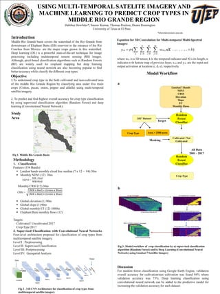
  • 1. USING MULTI-TEMPORAL SATELITE IMAGERYAND MACHINE LEARNING TO PREDICT CROP TYPES IN MIDDLE RIO GRANDE REGION Habibur Howlider*, Saurav Kumar, Thomas Poulose, Deana Pennington University of Texas at El Paso *hrhowlider@miners.utep.edu Introduction Middle Rio Grande basin covers the watershed of the Rio Grande from downstream of Elephant Butte (EB) reservoir to the entrance of the Rio Conchos from Mexico. are the major crops grown in this watershed. Deep learning (DL) is a powerful state-of-the-art technique for image processing including multitemporal remote sensing (RS) images. Although, pixel-based classification algorithms such as Random Forests (RF) are widely used for cropland mapping but deep learning classification using neural network are also becoming popular to find better accuracy while classify the different crop types. Objective 1.To understand crop type in the both cultivated and non-cultivated area of the middle Rio Grande Region by classifying area under five main crops (Cotton, pecan, onion, pepper and alfalfa) using multi-temporal satellite imagery. 2. To predict and find highest overall accuracy for crop type classification by using supervised classification algorithm (Random Forest) and deep learning (Convolutional Neural Network). Methodology 1. Classification Features (134 Bands):  Landsat bands monthly cloud free median (7 x 12 = 84) 30m  Monthly NDVI (12) 30m Monthly CRSI (12) 30m  Global elevation (1) 90m  Global slope (1) 90m  Global monthly ET (12) 1000m  Elephant Bute monthly flows (12) Targets: Cultivated / Uncultivated 2017 Crop Type 2017 2. Supervised Classification with Convolutional Neural Networks Four-level architecture proposed for classification of crop types from multitemporal satellite imagery. Level I : Preprocessing Level II: Supervised Classification Level III: Postprocessing Level IV: Geospatial Analysis Model Workflow Discussion For random forest classification using Google Earth Engine, validation overall accuracy for cultivation/non cultivation was found 94% where validation accuracy was 73%. Deep learning classification using convolutional neural network can be added to the predictive model for increasing the validation accuracy for each dataset. NDVI = Landsat 7 Bands NDVI CRSI Elevation Slope ET Monthly Flows Random Forest Classifier 2017 Dataset All Data 2001 - 2017 Crop Type Area > 2500 acres Crop Type Cultivated / Not Cultivated Target Masking Random Forest Classifier Fig 2 . 3-D CNN Architecture for classification of crop types from multitemporal satellite imagery Fig 1. Middle Rio Grande Basin ),( ,,, 000 bnwy nkejdickcde xij M j M i N kn      Equation for 3D Convolution for Multi-temporal Multi-Spectral Images: where wkij is a 3D tensor, k is the temporal indicator and N is its length, n indicates n-th feature map of previous layer, xcde and ycde are the input and output activation at location (c, d, e), respectively. Fig 3: Model workflow of crop classification by a) supervised classification algorithm (Random Forest) and b) Deep Learning (Convolutional Neural Network) using Landsat 7 Satellite Imagery Study Area CRSI = a b