Cocoa agroforestry for increasing forest connectivity in a fragmented landsca...
Poster
1. Pest Control on Mount Parihaka
The Mackesy Bush Landcare Group (MBLG) are currently completing rat
baiting operations in the Mackesy Bush area, located on the southern end of
Parihaka Scenic Reserve, and are wanting to gradually expand their operations
to cover the entirety of Mount Parihaka. Analysis is needed to determine the
best method for expanding the bait lines, and the best line locations in relation
to the terrain. Locating properties adjacent to the reserve and forestry, and
fringe properties containing native forest, is also needed in the analysis, to
determine which properties can be approached to place extra bait stations
within their boundaries.
Objective: To develop an appropriate pest control grid for the gradual expansion over Mount Parihaka, and identify adjacent
properties of the baited area to be targeted for further pest work
Introduction
Methods
• Data was primarily collected from Land and Information New Zealand (LINZ)
in NZGD49 New Zealand Map Grid coordinate system, including contours,
property, native and exotic forest, roads and tracks. Existing Mackesy Bush
bait stations were received from the MBLG as a GPX file, which was then
converted using the LINZ coordinate converter from WGS84 World Mercator
to NZGD 49 New Zealand Map Grid, and placed in GIS by adding the XY data
from excel.
• A new polyline shapefile for the desired displayed area, was then used to
clip roads, tracks, contours and property layers, using the clipping tool.
• Using the selection tool, the Property layers that were part of the Parihaka
Scenic Reserve were selected and exported to a new shapefile. Parcels were
then dissolved using the dissolve data management tool, to create one
polygon.
• A 150m buffer was created between surrounding private properties and
the area of the bait lines using the Data analysis, proximity, buffer tool.
• Bait lines were created by creating a new polyline shapefile and manually
drawing a best fit line that followed the general contour line, in order to make
the bait lines as easy as possible over the terrain. The line was then offset
using the COGO offset tool to a distance of 100m, and repeated until lines
covered the entire area to be baited. Each line was split into specified 50m
intervals using the COGO proportion tool.
• Each bait line was created as a separate point shapefile, and points were
placed on each line at the line break of each 50m segment. Bait lines were
separated into manageable areas, for the gradual expansion of the operation,
over the Parihaka according to where lines hit existing tracks or roads. A
perimeter bait line was created in the same way as the bait lines.
• Properties adjacent the reserve was selected using the select by location
tool, and setting the parameters to select properties that shared a line
segment with the dissolved reserve layer. Selected data was exported to a
new shapefile.
• Properties that have fringe native forest from Mount Parihaka Scenic
Reserve were selected using the select by location tool and setting parameters
to select data on the property layer that intercepted the native forest layer.
Selected data was exported to a new shapefile.
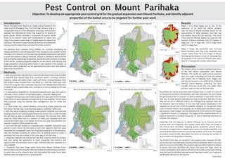
Results
Maps 1 to 4 show stages one to four of the
expansion of an ideal bait station network
over the area of Mount Parihaka, based on the
requirements of 100m between each bait line
and stations placed at 50m spacing’s. The result
is the need for 490 bait stations to cover the 370
hectares of Mount Parihaka, with 103 stations in
stage one, 137 in stage two, 153 in stage three
and 97 in stage four.
Maps 5 shows the properties that surround
Mount Parihaka, and map 6 the properties that
contain native forest from the fringes of Mount
Parihaka Scenic Reserve. A total of 146 properties
are adjacent to the reserve or forestry area, and a
total of 171 properties contain native forest.
Discussion
Boundaries are mainly associated with existing tracks or roads, for ease of
on the ground boundary identification. Bait lines have been set up to follow
the general direction of contours, as well as allowing for loop backs onto the
next line, to make physical operations as easy as possible. Bait lines on the
map are set out in different colours, for distinguishing separate lines and
the direction each line follows on the map. Bait station coordinates in the
network can be put into a GPS to establish locations on the ground. Initial
costs of the bait stations, and ongoing costs of keeping the operation in place,
will require a large budget, and the maintenance of the network will require
a significant amount of manpower. The stages of the network allow for its
gradual expansion as funding is acquired, as well as attaining volunteers to
maintain the network.
Properties that are adjacent to Mount Parihaka Scenic Reserve and the
forestry area, and properties that contain native forest from the fringe of
the reserve were identified. Targeting private properties around Mount
Parihaka is an opportunity to expand pest control into private properties, and
would provide added protection around the outskirts of the area. This added
protection would benefit native flora and fauna by reducing the number of
pest numbers reaching Mount Parihaka.
The forestry block was not included in the property layer obtained off LINZ,
and it had to be manually drawn and boundaries estimated, which is an issue
with the accuracy of the data. The property layer also did not give the address
of houses that were identified; this means that when the stage comes to
contact landowners, each address will have to be looked up manually. Finding
data that had this attribute attached would have been useful, as it is going to
significantly add time to the process.
Mount Parihaka Scenic Reserve is a large reserve located in the
urban area of Whangarei City. The 241m high volcanic cone is a
recognisable feature of the Whangarei landscape, and has been
awarded the international Green Flag Award for its quality of
green spaces. Mount Parihaka is comprised of mature native
forest on its western slope, with combinations of valleys and
ridges that provide a wide range of habitat types for native flora
andfauna.Theeasternslopeisplantedinforestry,andresidential
housing and the Hatea River surround the entire outskirts.
Thisanalysisshowsanoptionofgradualexpansion
of the bait station procedures over Mount
Parihaka. The results are a pest control extension
over four stages, extending out from the existing
pest control line in Mackesy Bush. Stages one
and two are located in the native forest of Mount
Parihaka Scenic Reserve, protecting the most
valuable flora and fauna first, and stages three
and four continue into the forestry area.
Emily Lloyd
Map 1 Map 2
Map 3 Map 4
Map 5
Map 6