1. USE OF MICROSIMULATION TO ASSESS HCM 2010 METHODOLOGY FOR
OVERSATURATED FREEWAY SEGMENTS
by
Dusan Jolovic
A Thesis Submitted to the Faculty of
College of Engineering and Computer Science
in Partial Fulfillment of the Requirements for the Degree of
Master of Science
Florida Atlantic University
Boca Raton, Florida
May 2012
3. USE OF MICROSIMULATION TO ASSESS HCM 2010 METHODOLOGY FOR
OVERSATURATED FREEWAY SEGMENTS
By
Dusan Jolovic
This thesis was prepared under the direction of the candidate' thesis Advisor, Dr.
Aleksandar Stevanovic, Department of Civil, Environmental, and Geomatics
Engineering, and has been approved by the members ofhis supervisory committee. It was
submitted to the faculty of the College of Engineering and Computer Science and was
accepted in partial fulfillment ofthe requirements for the degree ofMaster of Science.
SUPERVISORY COMMITTEE:
~~P.D. Scarlatos, Ph.D. . ~
Chair, Department ofCivil, Environmental
and Geomatics Engineering
~~.-
Khaled Sobhan Ph.D.
ohammad I s, .D.
Interim Dean, College ofEngineering and Computer Science
!!,:,;:zfn~--Dean, Graduate College
111
4. iv
ACKNOWLEDGEMENTS
I am very grateful to my advisor Dr. Aleksandar Stevanovic for his patient and wise
guidance and support through my graduate studies at the Florida Atlantic University. I am
also thankful to Jarice Rodriguez for providing invaluable support and ideas for this
research. I also want to thank Dr. Evangelos Kaisar for his advices during my studies.
Finally, I would like to express gratitude to Dr. Vladislav Maras, from the University
of Belgrade whose judgment and recommendation made all this possible.
5. v
ABSTRACT
Author: Dusan Jolovic
Title: Use of Microsimulation to Assess HCM 2010 Methodology for
Oversaturated Freeway Segments
Institution: Florida Atlantic University
Thesis Advisor: Dr. Aleksandar Stevanovic
Degree: Master of Science
Year: 2012
Highway Capacity Manual (HCM) 2010 methodology for freeway operations
contain procedures for calculating traffic performance measures both for undersaturated
and oversaturated flow conditions. However, one of the limitations regarding
oversaturated freeway weaving segments is that the HCM procedures have not been
extensively calibrated based on field observations on U.S. freeways. This study validates
the HCM2010 methodology for oversaturated freeway weaving segment by comparing
space mean speed and density obtained from HCM procedure to those generated by a
microsimulation model. A VISSIM model is extensively calibrated and validated based
on NGSIM field data for the US 101 Highway. Abundance of the NGSIM data is utilized
to calibrate and validate the VISSIM model. Results show that HCM methodology has
significant limitations and while in some cases it can reproduce density correctly, the
6. vi
study finds that speeds estimated by the HCM methodology significantly differ from
those observed in the field.
7. vii
USE OF MICROSIMULATION TO ASSESS HCM 2010 METHODOLOGY FOR
OVERSATURATED FREEWAY SEGMENTS
LIST OF FIGURES ........................................................................................................... ix
LIST OF TABLES............................................................................................................. xi
1. INTRODUCTION ...................................................................................................... 1
1.1. Research Goal ...................................................................................................... 2
1.2. Research Tasks..................................................................................................... 3
1.3. Thesis Organization.............................................................................................. 4
2. LITERATURE REVIEW ........................................................................................... 6
2.1. Previous Analyses of Traffic Facilities under Oversaturated Conditions............ 6
2.2. Previous Analyses of Weaving Segment Capacity.............................................. 8
2.3. Previous Efforts on Calibration and Validation of Simulation Models ............. 10
2.4. Summary of Literature Review.......................................................................... 14
3. MICROSIMULATION MODEL DEVELOPMENT............................................... 15
3.1. Microsimulation software description................................................................ 18
3.1.1. Study Area .................................................................................................. 22
3.2. Calibration of the VISSIM Model...................................................................... 23
3.2.1. Overview of VISSIM Car Following Model Parameters ........................... 24
3.2.2. Car Following Parameters Adjustment....................................................... 26
3.2.3. T-test Statistics............................................................................................ 35
3.2.4. Lane Change Parameters Adjustment......................................................... 45
8. viii
3.3. Model Validation................................................................................................ 50
4. HCM METHODOLOGY FOR DIRECTIONAL FREEWAY FACILITIES.......... 54
4.1. Procedure for FREEVAL engine output............................................................ 55
5. RESULTS AND DISCUSSION............................................................................... 68
5.1. NGSIM flows as a FREEVAL traffic input....................................................... 69
5.2. VISSIM traffic demand as a FREEVAL traffic input........................................ 72
5.3. Maximal traffic volume as a FREEVAL traffic input........................................ 76
5.4. Discussion .......................................................................................................... 81
6. CONCLUSIONS....................................................................................................... 85
6.1. Conclusions........................................................................................................ 85
6.2. Limitations of the Study and Future research .................................................... 87
APPENDIX A................................................................................................................... 88
APPENDIX B................................................................................................................... 93
BIBLIOGRAPHY............................................................................................................. 95
9. ix
LIST OF FIGURES
Figure 1 Overall methodology............................................................................................ 4
Figure 2 VISSIM and field geometry match..................................................................... 16
Figure 3 Car following logic developed by Wiedemann [20] .......................................... 20
Figure 4 Study area - US 101, CA.................................................................................... 23
Figure 5 NGSIM vs. VISSIM speed for CC0=4.92ft and CC1=0.9s ............................... 28
Figure 6 NGSIM vs. VISSIM flow for CC0=4.92ft and CC1=0.9s ................................. 29
Figure 7 NGSIM vs. VISSIM speed for CC0=6.0ft and CC1=1.1s ................................. 30
Figure 8 NGSIM vs. VISSIM flow for CC0=6.0ft and CC1=1.1s ................................... 31
Figure 9 NGSIM vs. VISSIM speed for CC0=7.0ft and CC1=1.3s ................................. 32
Figure 10 NGSIM vs. VISSIM flow for CC0=7.0ft and CC1=1.3s................................. 33
Figure 11 NGSIM vs. VISSIM speed for CC0=7.61 and CC1=1.45s.............................. 34
Figure 12 NGSIM vs. VISSIM flow for CC0=7.61 and CC1=1.45s................................ 35
Figure 13Validation of a model considering average speed............................................. 51
Figure 14 Validation of a model considering average flow.............................................. 52
Figure 15 Layout of the FREEVAL procedure based on HCM2010 ............................... 56
Figure 16 Weaving segment measurements ..................................................................... 58
Figure 17 Initial FREEVAL screen .................................................................................. 59
Figure 18 Segment type defining...................................................................................... 59
Figure 19 Main input window in FREEVAL ................................................................... 64
10. x
Figure 20 Weaving volume calculator in FREEVAL....................................................... 65
Figure 21 Density comparisons for the NGSIM traffic input........................................... 71
Figure 22 Speed comparisons for the NGSIM traffic input.............................................. 72
Figure 23 Density comparisons for the VISSIM traffic input .......................................... 75
Figure 24 Speed comparisons for the VISSIM traffic input............................................. 76
Figure 25 Density comparisons for the maximal acceptable traffic input........................ 79
Figure 26 Speed comparisons for the maximal acceptable traffic input........................... 80
11. xi
LIST OF TABLES
Table 1 Proposed range of VISSIM car following parameters......................................... 26
Table 2 T-test conducted for speed values per lane.......................................................... 37
Table 3 T-test conducted for flow values per lane............................................................ 37
Table 4 Aggregate flow and speed comparison per lane - first 15-min interval............... 39
Table 5 Aggregate flow and speed comparison per lane - second 15-min interval.......... 39
Table 6 Input-Output analysis - first 15-min interval....................................................... 40
Table 7 Input-Output analysis - second 15-min interval .................................................. 41
Table 8 Field data for vehicle distribution by lane - first 15-min interval........................ 42
Table 9 VISSIM data for vehicle distribution by lane - first 15-min interval .................. 42
Table 10 Field data for vehicle distribution by lane - second 15-min interval................. 43
Table 11 VISSIM data for vehicle distribution by lane - second 15-min interval............ 43
Table 12 Field average headway by time period - first 15-min interval........................... 44
Table 13 VISSIM Average headway by time period - first 15-min interval .................... 44
Table 14 Field average headway by time period - second 15-min interval...................... 45
Table 15 VISSIM average headway by time period - second 15-min interval................. 45
Table 16 Comparison of lane changes per time period - first 15-min interval................. 48
Table 17 Comparison of lane changes per segment - first 15-min interval...................... 49
Table 18 Comparison of lane changes per time period - second 15-min interval ............ 50
Table 19 Comparison of lane changes per segment - second 15-min interval ................. 50
12. xii
Table 20 Time interval scale factor calculation................................................................ 62
Table 21 Time step duration during oversaturated conditions.......................................... 66
Table 22 Data comparison for CAF=1.0 .......................................................................... 69
Table 23 Data comparison for CAF=0.9 .......................................................................... 70
Table 24 Data comparison for CAF=1.0 .......................................................................... 73
Table 25 Data comparison for CAF=0.9 .......................................................................... 74
Table 26 Data comparison for CAF=1.0 .......................................................................... 77
Table 27 Data comparison for CAF=0.9 .......................................................................... 78
13. 1
1. INTRODUCTION
This chapter introduces the research problem. It summarizes the basic information
about the study, methodology steps and the tools used. The research goal, objectives and
tasks are proposed and finally a general organization of the thesis is given.
The Highway Capacity Manual (HCM) 2010 methodology for freeway operations
(Chapters 11, 12, 13) contains procedures for calculating traffic performance measures
only for undersaturated flow conditions on a basic, weaving and merge/diverge freeway
facilities. Once demand becomes greater than capacity of the freeway facility, (i.e.,
demand-to-capacity ratio exceeds value of 1.0) or Level-of-Service (LOS) reaches grade
F, HCM does not provide analytical procedures for calculating performance measures
such as density and space mean speed. However, using supplemental methodology from
HCM’s Chapter 25, it is possible to overcome the constraints related to the lack of proper
procedures for congested conditions on directional freeway facilities. Alternative
methodology is introduced as computational engine called FREEVAL (FREeway
EVALuation) and is developed in the MS Excel environment. According to the
FREEVAL’s user guide, FREEVAL is a computerized, worksheet based environment
designed to faithfully implement the computation for undersaturated and oversaturated
directional freeway facilities [1]. One of the limitations on oversaturated freeway
segments’ evaluation is that the HCM procedures have not been extensively calibrated
14. 2
based on field observations on U.S. freeways [2]. After FREEVAL was developed,
calibrated and validated for the HCM 2000 edition, no studies have been conducted to
verify how accurately this model can replicate real world performance measures when
oversaturation of the facility occurs.
1.1. Research Goal
The goal of this research is to evaluate effectiveness of HCM analytical methodology
for freeway weaving sections under congested traffic conditions. In order to evaluate
effectiveness of HCM methodology, this study has an objective to compare performance
measures (average density and space mean speed) between HCM methods and the
calibrated and validated microsimulation model. This study addresses four null
hypotheses in order to obtain conclusions important to reach the goal of this study. All
hypotheses are associated to the space mean speed and density. Hypotheses are:
1. H0(1) – Space mean speeds obtained with HCM procedure are not significantly
different than space mean speeds obtained from VISSIM
2. H0(2) – Densities obtained with HCM procedure are not significantly different than
densities obtained from VISSIM
3. H0(3) – Space mean speeds obtained with VISSIM are not significantly different
than space mean speeds from field
4. H0(4) – Densities obtained with VISSIM are not significantly different than
densities from field
Additionally, four alternative hypotheses, opposite from null hypotheses are set. The
alternative hypotheses are:
15. 3
1. H1(1) – Space mean speeds obtained with HCM procedure are significantly
different than space mean speeds obtained from VISSIM
2. H1(2) – Densities obtained with HCM procedure are significantly different than
densities obtained from VISSIM
3. H1(3) – Space mean speeds obtained with VISSIM are significantly different than
space mean speeds from field
4. H1(4) – Densities obtained with VISSIM are significantly different than space
mean speeds from field
The hypothesis testing procedure uses data from a sample to test two competing
statements denoted by H0 and H1.
1.2. Research Tasks
While conducting this study three major tasks are distinguished as follows:
1. Build a model in microsimulation software based on New Generation Simulation
(NGSIM) high-fidelity data for part of the US 101 (Hollywood Freeway) in
California
2. Calibrate and validate the microsimulation model in order to replicate real world
conditions
3. Set out an analytical computational engine FREEVAL which is the supplemental
tool of HCM 2010
To make the overall process clear, the methodology flowchart is presented in Figure
1:
16. 4
Figure 1 Overall methodology
1.3. Thesis Organization
The thesis is divided into seven chapters. Chapter 2 gives insight on previous research
related to this study. Literature review is divided into three different parts: studies of
traffic facilities under oversaturated conditions, studies of weaving segment capacity and
configuration types and lastly literature on calibration and validation of simulation
models. At the end of Chapter 2, a summary of the review is provided. Chapter 3
discusses microsimulation software in general, building a model for this study and basic
characteristics of the study area. It also describes calibration and validation of a model.
Elementary description of car following and lane changing parameters is given. Further,
most influential parameters are described and their adjustment is explained thoroughly.
Model validation shows results on applicability of the microsimulation model to the area
17. 5
considered. Chapter 4 explains in steps, the methodology of HCM for directional freeway
facilities. In Chapter 5, results of the comparison between analytical and stochastic
models are presented and discussed. Finally, Chapter 6 presents conclusions, limitations
of the study and ideas for future research.
18. 6
2. LITERATURE REVIEW
This chapter presents findings from literature review, sorted in three subchapters
based on research goals. Firstly, review of papers related to oversaturated conditions of
freeway facilities is presented. Second subchapter gives an insight in the analysis of
weaving segment capacity and configuration types for freeway facilities. The third part
summarizes articles and studies on calibration and validation of simulation models.
Finally, a summary of literature review findings is provided at the end of the chapter.
2.1. Previous Analyses of Traffic Facilities under Oversaturated
Conditions
Oversaturated conditions have always been more difficult to evaluate compared to
non-congested traffic environment. HCM supports this statement since basic
methodology for directional freeway facilities cannot evaluate freeway facilities when
oversaturated conditions occur (i.e., for densities greater than 43pc/mi/ln). Only with
supplemental procedures contained in HCM’s Chapter 25 is it possible to evaluate
congested conditions. This procedure was initially developed for HCM 2000 and
accompanied with computational worksheet-based environment in MS Excel.
Baumgartner [3] conducted a research of alternative methods of reporting degrees of
failure of a facility. He proposed three different options aimed in describing facility
performance even under oversaturated conditions. First option considers extending usual
19. 7
LOS by adding G, H and I thresholds beyond traditional mark F for the failure of the
facility’s normal operations. The second option proposes expansion of performance
reports beyond the usual peak period, using a multiple hour base to report conditions
worse or equal to LOS D. The final option proposes to assign a numerical grade to the
LOS for a facility multiplied by the amount of hours which is obtained for the each LOS.
An expanded range for LOS is taken into consideration. The result would be ‘congestion
index’ and the degree of congestion would be based on it.
May et al. [4] described a step by step methodology for analytical assessment of
freeways facilities and pointed into limitations. This research was part of HCM2000
methodology which for the first time assesses oversaturated conditions on directional
freeway facilities. Still, methodology has limitations such as that first and the last interval
of examined facility have to be undersaturated. Authors have successfully validated the
model called FREEVAL (FREEway EVALuation) for oversaturated field data developed
for the HCM 2000. However, authors concluded that further research is needed to
calibrate and validate the speed flow or speed density relationship in the congested
regime.
Hall et al. [5] as a key part in this research undertook validation of HCM 2000
procedure for congested conditions on freeway facilities using field data from six sites.
Speed is used for validation due to field data limitations; other measures that can be used
are traffic flow, travel time etc. A sample of vehicle speeds is used for validation in each
section of a freeway which can lead to some errors between observed and actual mean
speeds. While conducting simulations, authors noticed that even small changes in
20. 8
capacity or random seeds can contribute to significant difference in the results for the
same model. Conclusion was that analysis for congested freeway facility was very
sensitive to the parameter inputs and approach. Authors found that both the HCM based
procedures and various simulations software can replicate average speeds across the
freeway facilities but capacity adjustment was necessary in every model deployed.
Bloomberg et al. [6] conducted a study to investigate comparison of the travel times,
average speeds and lane densities obtained from the simulation models and the same type
of data from the HCM methodology calculations. Outputs from 6 different simulation
tools were compared on a test bed which included a freeway with two interchanges and
two cross-streets. Comparison between measures of effectiveness focused on average
speeds and lane densities because they were consistent with the HCM calculations.
Findings showed that as the traffic demands get closer to the capacity, there was more
variability in results from the models. Largest differences between HCM and simulation
models occurred for those sections that operated at or above capacity. This study
investigated only moderate congestion levels; demand to capacity ratios went up to 1.10.
It can be concluded that model selection is not as much important as ability to effectively
code, test, calibrate and apply particular simulation model.
2.2. Previous Analyses of Weaving Segment Capacity
Numerous studies have been done in past regarding this topic. Still, improvement are
made and the latest example is that in new HCM 2010, methodology regarding
configuration types of weaving areas is completely changed.
21. 9
Roess et al. [7] developed better approach than existing one in the HCM2000 to
estimate weaving segment capacity. The methodology substitutes a regression-based
equation for the burdensome tables of the HCM 2000. Sensitivity of capacities of four
freeway weaving sections was analyzed for various values of volume ratio (VR). The
methodology included two types of capacity, each computed by an algorithm
recommended by the authors. The minimum of the two values compared was proper
capacity. Unlike HCM 2000, no multipage tables were needed and there was no need to
address five different capacity constraints. The same capacity saturation level of
43pc/h/ln was used as in HCM 2000. Average speed of weaving and non-weaving
vehicles in a weaving segment was estimated through series of equations. Potential
modeling approach for the capacity and level of service prediction was developed for
freeway weaving sections.
Lownes and Machemehl [8] studied sensitivity of VISSIM simulation capacity based
on various driver behavior parameters values. Part of investigated freeway corridor was
5-lane weaving section. One parameter was modified at the time (four different capacity
levels were used in parameter evaluation) and the effect of its change on capacity was
studied. In total, eleven parameters were investigated and comprehensive summary of
capacity sensitivity to parameter modification was presented.
Roess et al. [9] made an effort to estimate capacity of a weaving segment using
simulation software. Lane changing distributions and speed distributions by segment
were prime measures for comparing VISSIM model and NGSIM high-fidelity field data.
Reasonable matching was achieved both for freeway to freeway, ramp to freeway and
22. 10
freeway to ramp comparisons. To fit speed flow data, authors developed equation form
and applied it to each of the curve fits. Capacity was determined for different values of
volume ratio (VR). Beside expected results that as VR increase, the capacity decreases,
none of weaving capacities approach basic freeway capacity of 2300 pc/h/ln on an
equivalent section. Additional sites have to be examined to tell if some commonalities in
the results can be found.
Roess and Ulerio [10] did a comprehensive study in order to improve current HCM
2000 methodology regarding weaving configuration types. Authors replaced
configuration types A, B and C from HCM 2000 with direct measures of lane changing
activity in the weaving segment. Degree of turbulence in the weaving areas was well
defined with lane changing intensity and it can be used as performance parameter.
Constrained versus unconstrained operation issue has not been considered in this work.
2.3. Previous Efforts on Calibration and Validation of Simulation
Models
Skabardonis et al. [11] showed that car following sensitivity factor, lane changing
aggressiveness and percentage of freeway through vehicles that yield to merging traffic
significantly affect the microsimulation results. Deploying basic settings in the software,
researchers found that program mostly under predicts the average speeds. Calibrated
model managed to successfully represents field conditions of weaving area – speed of
component flows were replicated good but lane changing behavior was not considered.
Pesti et al. [12] used VISSIM microscopic traffic simulation to replicate a range of
ramp spacing scenarios of an entrance ramp followed by an exit ramp with an auxiliary
23. 11
lane under various traffic conditions. Paper aimed at determining relationships between
weaving length, speed and overall vehicle operations. Calibration of a model was set on
finding the best parameter combination which can minimize differences between
modeled and field data. Researchers found that the lane changing pattern was not
uniformly distributed along weaving segment and vehicles which entered the freeway
within first 250ft accepted shorter gaps for lane changing maneuvers. This indicated a
need for several sets of parameters for microsimulation model in order to replicate lane
changing patterns over weaving segments.
Gomes et al. [13] developed and calibrated VISSIM model for a congested freeway.
Relative impacts of driving behavior parameters were addressed. Parameters were
selected by performing iterative runs and visual evaluation of the speed contour plot.
Manual fine tuning of the parameters was applied. Three car following parameters were
modified in this study (CC0, CC1 and CC4/CC5 pair). The effect of these parameters on
capacity, queue length etc. had not been quantified. No previous efforts with the aim of
quantifying the impact of modification of driver behavior parameters on capacity were
found. In other words, no systematic procedure was outlined for use by a prospective
VISSIM user.
Park and Qi [14] proposed a procedure for model calibration. Signalized intersection
built in VISSIM was a test bed; Latin Hypercube design algorithm was used to reduce
number of parameter combination and Latin Hypercube Sampling Toolbox in MatLab to
generate predetermined number of scenarios. Feasibility test was useful in identifying
appropriate ranges of calibration parameters. Calibration parameters were optimized by
24. 12
Genetic Algorithm calibration parameter are optimized and close matching was achieved
between field and simulation outputs. However, only travel time was used for model
calibration which might be insufficient performance measure in the calibration process.
Menneni et al. [15] developed a calibration procedure for psycho-physical and car
following models using VISSIM. Study was built upon macroscopic calibration of
microsimulation models. For microscopic calibration, relative distance vs. relative
velocity charts from NGSIM vehicle trajectories was used. One of the disadvantages of
microscopic data was that they are collected over small period of time. Multiple
calibration parameter sets analyzed in this study helped researchers to reduce number of
influential calibration parameters in VISSIM to CC1 and CC2 regarding speed-flow
based macroscopic calibration. Simplified methodology for calibration based on
parameters CC1 and CC2 was presented.
Dowling et al. [16] developed guidelines for calibration of microsimulation models.
The test bed consisted of a freeway section with two diamond interchanges and a parallel
arterial with signalized intersection. Authors divided calibration procedure into three
steps, calibration for capacity at bottlenecks, route choice calibration and overall system
performance calibration against field measurements such as travel time and delay,
respectively. In case that one facility is calibrated, second step in the procedure should be
neglected. Parameters were classified into two groups: parameters chosen to be adjusted
and ones left default. Global and local parameters were classified based on how they
affect simulation process. Once global parameters were adequate, adjustment of local
parameters was deployed through fine tuning process. Researchers gave an example of
25. 13
mean headway as a main calibration parameter. Authors indicated that model satisfied
calibration criteria.
Fellendorf and Vortisch [17] presented how to validate microscopic model both on a
microscopic and macroscopic level. Authors explained methodology of a VISSIM flow
model and described basics for model implementation. Regarding calibration, it was
shown that the model can reproduce the real world process of a faster car approaching a
slower one and follow it. One of the significant observations was importance of time step
for simulation quality. More realistic acceleration modeling may be achieved with
smaller time steps. Model was successfully validated for German and U.S. freeways after
a model adaptation to the local traffic situation. Authors concluded that national traffic
regulations and driving styles have to be considered in order to build a good model which
can represent field conditions accurately.
Zhang and Owen [18] pointed out the importance of real world data availability for
model validation purposes. Primary case was weaving section in Baltimore. On a
macroscopic level validation was accompanied by average speed, headway and travel
time, while for microscopic conditions speed change patterns, vehicle trajectory plots and
headway distributions were compared. Scatter plots and animation were used as graphical
comparison techniques. Authors revealed that averaging traffic variables along studied
section can be misleading; instead, distributions over time and space, such as speed
distribution by lane, should be considered. However, speed-flow relationship for a
congested condition on a freeway segment was not attempted in the model because
26. 14
congested scenarios vary with demand combination levels and mandatory lane change
scenarios and are difficult to present in a simplified relationship.
2.4. Summary of Literature Review
First part of the literature review provides an insight on studies which investigated
congested conditions of traffic facilities. Although FREEVAL model is validated by May
et al. [4] further research was recommended to prove model ability to replicate real world
conditions. In the second part of the review, modeling efforts and capacity assessment of
weaving segments are summarized. Finally, numerous studies on calibration and
validation of microsimulation models are reviewed. Although previous studies cover
similar problems as the one proposed in this research, none of them compare
microsimulation with HCM analytical model for directional freeway weaving segments
under congested conditions. Furthermore, not many of the previous studies were based on
high fidelity data from the field as it is the case in this research. Those are the points
where this study can contribute to the future relevant research on freeway facilities
evaluation.
27. 15
3. MICROSIMULATION MODEL DEVELOPMENT
This chapter describes a methodology used to build a VISSIM model which correctly
represents oversaturated freeway conditions on US 101 in California. This model is then
used for further evaluation of HCM 2010 methodology for directional freeway facility
under oversaturated conditions which is the goal of this research. Further, comprehensive
calibration and validation efforts are explained. Parameters from car following and lane
changing models are explained and ones that influence the model mostly are assessed. T-
test is used as a statistical measure to confirm model resemblance of a field conditions.
Lastly, model validation is done in order to achieve high fidelity and high credibility of a
microscopic traffic simulation.
Basic steps of the modeling procedure are:
- Obtain geometry data and set the network in VISSIM to represent current field
conditions in the best way
- Load network with proper traffic demand and distribute vehicles throughout the
network by using routing decisions
- Run simulation and observe closely if any unusual vehicle movements occur.
Considering that videos from the field are available, check if any large
discrepancies exist (e.g. non-existing queueing in the field at on/off ramps)
- Export and post-process data in spreadsheets
28. 16
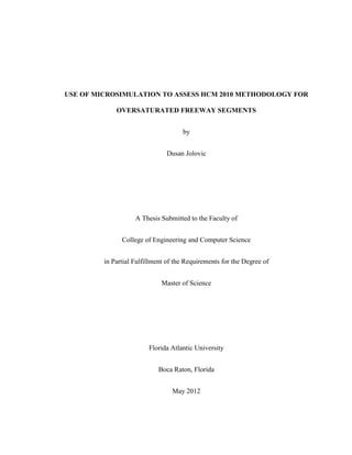
Google Maps and Google Earth are used to get the latest information on the geometry
of the freeway segment and to measure lane widths. Geometry of a VISSIM model is
built based on a background image from Google Earth as shown on Figure 2.
Figure 2 VISSIM and field geometry match
Traffic data from the field were in form of traffic counts while VISSIM has to be
load with traffic demand. Model is gradually tested for different traffic demands, each
time higher and higher until proper demand is found. Finally, when flow values from the
field and model outputs are compared no significant difference is found. Since VISSIM
distributes vehicles randomly in the network, routing decisions is set next. This allows
redistributing vehicles in the network as it is found to be in the field (e.g., how many
vehicles leave the network at off-ramp in one time interval). If routing decision option is
29. 17
not incorporated, vehicles take random path which cannot replicate real world data
properly.
While checking the model for discrepancies, it was noted that auxiliary lane
between on and off ramp in the model often experience vehicles queueing, while on the
NGSIM recorded camera videos that was not the case. The problem is solved by
adjusting driving behaviors parameters in calibration process. Second problem regarding
microsimulation model was related to the vehicle speeds. Period investigated represents
build up to congestion (from 7:50 AM-8:05 AM) and primarily congested conditions
(from 8:05 AM-8:35 AM) and speeds in almost all lanes did not exceed 30mph. In some
lanes speeds were as low as 16mph. Regardless how big warm up time (up to 1 hour) and
freeway demand per lane (up to 3000vphpl) is tested in the simulation model, speeds in
the model could not be lower than 35-40mph. Videos for the downstream segment were
not available, but it is perceived that downstream freeway segment experienced heavy
congested conditions, affecting speeds of the vehicles in modeled segment. Considering
that this is relatively short segment one directional facility, and desired speed distribution
for imported traffic compositions is set between 50 and 70mph, model could not account
for downstream congestions obviously present in the field. Solution was to set points of
reduced speed decisions at the ends of each lane so the model can account for
downstream congestion. Reduced speed decisions improved model results significantly
and made modeled speeds much closer to the field values.
Forty five minutes of processed data were available from NGSIM reports and total of
one hour of simulation is produced, including 15-min of warm up time.
30. 18
3.1. Microsimulation software description
In the last decade, computer processing performances increased rapidly, allowing
development of simulation software and implementation in various science disciplines.
Real world testing is costly and a lot of factors cannot be examined. Using simulation
software in transportation engineering, one can conduct planning and analyzing in safe,
fast and economical way and also examine scenarios based on different driving behavior
parameter values.
Currently there are more than a dozen of microsimulation software packages
available on market which can be used to represent traffic conditions on a smaller scale.
Some researchers did comprehensive comparisons [6] of available software and showed
that all of them have some advantages and disadvantages.
VISSIM is a software package developed at the University of Karlsruhe in Germany.
Initially it was designed to simulate ‘traffic in towns’ (meaning of abbreviation VISSIM
in German is Verkehr In Städten – SImulationsModell) but mode for freeway simulation
is also added later [19]. Latest update of the software allows multimodal and simulation
of pedestrian movements. VISSIM characterize discrete, stochastic and time step based
model where the vehicle units are represented as single entities. The software is based on
work of Wiedemann [20] and relies on psycho physical car following model which
essentially controls longitudinal movement of vehicles and lane changing algorithm for
lateral vehicle movements. Model assumes that drivers have a desired speed at which
they want to travel if they are not constrained by work zones, downstream queues, traffic
signals etc. Basic idea of the Wiedemann model is that the driver can be in one of four
31. 19
driving modes: free driving, approaching, following or braking. If no other vehicles or
physical obstruction is present downstream, driver is in the free driving mode. As the
driver approaches traffic signal or slow moving vehicles he starts to decelerate. Car
following logic defines the driver perception threshold and the regimes formed by these
thresholds. Since the driver is not able to estimate the speed of the slow moving leading
vehicle he makes his speed lower than the speed of a leading vehicle. After another
threshold is reached, driver accelerates again. The result is constant acceleration and
deceleration of a vehicle and mode change between the default ones. Figure 3 represents
car following logic and the thresholds and important distances for a vehicle unit. On the
vertical axis the distance to the leading vehicle is depicted while on the horizontal axis
the speed difference with positive values characterizing approaching process. Figure 3 is
drawn based on the existing one shown in VISSIM User Manual [21].
32. 20
Figure 3 Car following logic developed by Wiedemann [20]
Parameters showed at Figure 3 are defined as follow:
AX – desired distance between the front ends of vehicles in queue between two
successive vehicles
BX – speed dependent term in the desired minimum following distance
CLDV – closing delta velocity; threshold for recognizing small speed differences (this is
for short, decreasing differences)
SDV – threshold of speed difference at long distances. This is the action point where a
driver consciously observes that he approaches a slower leading car
SDX – threshold of increasing distance in the following process
OPDV – threshold for identifying small speed differences at short declining distances.
This is the action point where driver notices that his speed is lower than the leading
33. 21
vehicle and starts to accelerate
ABX – minimum following distance desired. It is the function of AX, a safety distance
BX and the speed with ABX (ABX=AX+BX*v)
The desired vehicle spacing (s) is an interval (ABX ≤ s ≤ SDX) and not a single value.
Building of a network in VISSIM is based on links and connectors topology. User
has to input data such as number of lanes link consists of, type of driver behavior
(freeway, arterial etc.) and lane width.
Vehicle input consists of importing vehicle volume, traffic compositions
(percentage of trucks, percentage of autos and RVs), and desired speed distributions of
different types of vehicles. With routing decisions user can allocate traffic input
throughout the network in order to represent real world traffic distribution.
The reasons why VISSIM is chosen as basic software to conduct this study are:
- Author has gained a good background knowledge of VISSIM while working on a
several projects in this software during studies
- Multimodal Intelligent Transportation Lab of Florida Atlantic University has
already purchased software package so no additional cost was needed in
conducting this study
- Non-calibrated basic model of this particular weaving section was available as a
courtesy of researchers from University of Waterloo, Canada [22]
- Numerous studies conducted so far with VISSIM proved that software can
realistically represent real world traffic conditions
34. 22
- Comprehensive literature was available regarding calibration and validation of
VISSIM microsimulation models
3.1.1. Study Area
The southbound US Highway 101 (Hollywood Freeway) in Los Angeles, CA, is used
as a case study to investigate comparison between microsimulation model and results
obtained by HCM 2010 methodology for weaving sections. The US 101 Highway
weaving segment consists of 5 mainlines, one on ramp entrance at Ventura Boulevard
and one off ramp exit at Cahuenga Boulevard, 698ft apart (see Figure 4). An auxiliary
lane is present through a portion of the corridor between the on and off ramps. The length
of the whole segment to be investigated is 2100ft.
The NGSIM datasets represent the most detailed and accurate field data collected to
help in traffic microsimulation research and development [23]. Total of 45 minutes of
data are available; data are broken down into 5 minute periods and then summarized into
three 15 minute period reports. These periods represent the transition between
uncongested and congested conditions and full congestion during peak period. The data
provided are aggregated by time, lane and length segments of 100 feet. Additionally, in
NGSIM dataset are available CAD drawings, ArcGIS maps, aerial ortho-photos, loop
detector data for the whole day when the study is conducted and video recordings from 8
cameras in three 15 minute intervals.
35. 23
Figure 4 Study area - US 101, CA
3.2. Calibration of the VISSIM Model
Calibration is accomplished based on traffic flow and vehicular speed aggregated per
freeway lane. First, all driving behavior parameters for the car following model are
explained. Several of them, found to have most influence on this model are
comprehensively discussed. Second, most influential lane change parameters for this
model are also presented and their adjustment is discussed. Last subchapter summarizes
calibration outcomes and shows t-test statistics to demonstrate the level of model
calibration. Since NGSIM data reports provide numerous of analysis, beside
aforementioned calibration measures, additional measures available from reports are
compared. Those are: input-output analysis for vehicles entering/exiting the freeway,
36. 24
vehicle distribution by lane and average headway by time period and lane. All of these
comparisons are done for three 15 minute intervals. The reason of presenting additional
measures is enhancement of model validity.
Simulation software is dependent on a set of parameters which regulate modes of
driving behavior for car following and lane changing logic. Without adjusting default
parameter values, it is very hard to achieve close match of field data and model results.
3.2.1. Overview of VISSIM Car Following Model Parameters
Calibration is a process of modification of driving behavior parameter values in such
a way that simulation software can best reproduce the driver behavior and traffic
performances on the particular traffic facility. In other words, a calibration should result
in a valid model.
Car following model for freeway modeling consists of ten different parameters which can
be adjusted by the user [21]. Those are:
1. CC0 (Standstill distance): defines the desired distance between stopped cars. Its
default value is 4.92 ft.
2. CC1 (Headway time) is the time in seconds that a driver wants to keep. The
default value is 0.9 s. As this value increases, driver will be paying more attention to the
traffic conditions. At a given speed, the safety distance (minimum distance the driver
keeps while following another car) is computed as: dx safe = CC0 + CC1 * v [m/s].
3. CC2 (Following variation) restricts the longitudinal oscillation or how much more
distance than the desired safety distance a driver allows before he intentionally moves
37. 25
closer to the car in front. The default value is 11.52ft and results in a quite stable
following process.
4. CC3 (Threshold for entering Following) controls the start of the deceleration
process, when a driver recognizes a leading slower vehicle. In other words, it defines how
many seconds before reaching the safety distance the driver starts to decelerate. The
default value is -8 and results in a fairly tight restriction of the following process.
5. CC4 and CC5 (Following thresholds) control the speed differences during the
state of following leading vehicle. Smaller values result in a more sensitive reaction of
drivers to accelerations or decelerations of the preceding car, i.e. the vehicles are more
tightly coupled. CC4 is used for negative and CC5 for positive speed differences. The
default values are +-0.35.
6. CC6 (Speed dependency of oscillation): Influence of distance on speed oscillation
while in following process. If set to 0 the speed oscillation is independent of the distance
to the leading vehicle. Larger values lead to a greater speed oscillation with increasing
distance. The default value is 11.44.
7. CC7 (Oscillation acceleration): Actual acceleration during the oscillation process.
The default value is 0.82 (ft/s2
).
8. CC8 (Standstill acceleration): Desired acceleration when starting from standstill.
The default value is 11.48 (ft/s2
).
9. CC9 (Acceleration at 80 km/h): Desired acceleration at 80 km/h. The default
value is 4.92 (ft/s2
)
38. 26
Comprehensive literature review is done regarding previous calibration efforts on
VISSIM. Based on these studies, range for every parameter is determined and presented
in Table 1. After comprehensive calibration efforts are done on a model used in this
research, values in the column titled ‘calibrated value’ are found to replicate the field
conditions in a best manner.
Table 1 Proposed range of VISSIM car following parameters
Parameter (unit) Range Default Value Calibrated Value
CC0 (ft) (2.0 to 20) 4.92 7.61
CC1 (s) (0.5 to 2.0) 0.9 1.45
CC2 (ft) (2.0 to 20) 13.12 11.52
CC3 (-4 to -15) -8.0 -7.31
CC4 (0.1 to 2.0) -0.35 -0.35
CC5 (0.1 to 2.0) 0.35 0.35
CC6 (0 to 12) 11.44 11.44
CC7 (ft/s2
) (0.5 to 1.5) 0.82 0.82
CC8 (ft/s2
) (6.4 to 11.5) 11.48 11.48
CC9 (ft/s2
) (2.1 to 7.5) 4.92 4.92
3.2.2. Car Following Parameters Adjustment
In total, 45 minutes of field data were available. All of the data were supported by
comprehensive analysis reports, which cover 15 minute intervals. Based on the ranges
from Table 1, parameter adjustment is done manually. After each change of parameter
values, simulation is executed and measures of effectiveness (space mean speed and
flow) are extracted and compared to the NGSIM data. This procedure has been repeated
until there were no significant differences between the model and the field values. The
biggest impact on the model performance measures is observed when parameters CC0,
CC1, CC2 and CC3 are changed. First two primarily affects the capacity [24] while CC2
and CC3 are perceptual thresholds that govern the following behavior of the drivers in the
car following model. As the vehicular flow values were know from the field data, it was
39. 27
perceived that for the default values of parameters CC0 and CC1, model flow output was
higher than the field values. By increasing CC0 in intervals of 1ft and the CC1 in
intervals of 0.2 seconds, and conducting comparison after each adjustment, final decision
is made to stop on values of 7.61 for CC0 and 1.45 for CC1. For the higher values
discrepancies with field data were significant.
On the Figure 5 to Figure 11, the effect of changing CC0 and CC1 values on
average speed and flow output from the model is presented. Four different scenarios for
different CC0 and CC1 values are generated. First scenario is built with default VISSIM
values for both parameters, in the second CC0 increases from the default value to 6.0ft
and CC1 up to 1.1 seconds, third scenario is for CC0 of 7.0ft and CC1 of 1.3 seconds and
the last scenario is the best fit. In the last scenario, no significant difference is
encountered between model and field values. Parameter values tested in the last scenario
are used as the final ones, which means that the model is considered calibrated for these
CC0 and CC1 values.
Since calibration is conducted with two 15-min sets, results are shown for both
periods. From Figure 5 to Figure 11 is evident that as standstill distance (CC0) and
headway time increase (CC1), flows and speeds decrease in the model. Since CC0
defines stopped distance between stopped cars, as this distance increase, fewer vehicles
can be traced per freeway mile. As the drivers pay more attention to the traffic conditions
on the road (increase of CC1 value), speed reduces due to safety concern of the drivers.
Ten simulation runs were conducted for each scenario to account for model stochasticity.
40. 28
For the default car following parameters CC0 and CC1, the difference in speed is
significant as depicted in Figure 5. Differences are in range from 10mph in auxiliary lane
to almost 30mph in most left lane. It is obvious that VISSIM does not follow trend of a
field data and that the speeds are constant over all lanes.
Figure 5 NGSIM vs. VISSIM speed for CC0=4.92ft and CC1=0.9s
Regarding flows, only auxiliary lane shows good match between field and
VISSIM data. For all other lanes VISSIM overestimate average flow as presented in
Figure 6. Overestimation goes from about 100vph for Lane 1 to 300vph for Lane 5.
0
10
20
30
40
50
60
Aux Lane 1 Lane 2 Lane 3 Lane 4 Lane 5
Speed(mph)
Lane
VISSIM Average Speed (mph) Field Average Speed (mph)
41. 29
Figure 6 NGSIM vs. VISSIM flow for CC0=4.92ft and CC1=0.9s
When CC0 increases to 6.0ft and CC1 to 1.1 seconds, difference becomes smaller
but still large enough to require further adjustments in order to achieve good calibration
results. In this case the closest match is noted for auxiliary lane where difference lowered
to 6mph. All other lanes are still far from satisfying outcomes as it can be seen in Figure
7.
0
500
1000
1500
2000
2500
Aux Lane 1 Lane 2 Lane 3 Lane 4 Lane 5
Flow(vph)
Lane
VISSIM Average Flow (vph) Field Average Flow (vph)
42. 30
Figure 7 NGSIM vs. VISSIM speed for CC0=6.0ft and CC1=1.1s
In case of flows, in Figure 8 is clear that difference is still significant. It is
somehow similar as for the default parameter values, which implies that this adjustment
had more influence on speed values than on traffic flow.
0
10
20
30
40
50
60
Aux Lane 1 Lane 2 Lane 3 Lane 4 Lane 5
Speed(mph)
Lane
VISSIM Average Speed (mph) Field Average Speed (mph)
43. 31
Figure 8 NGSIM vs. VISSIM flow for CC0=6.0ft and CC1=1.1s
When CC0 and CC1 are increased even more, matching between field and
modeled speeds becomes much better. Lane two achieves perfect fit, while values for all
other lanes fall in the range of standard deviations. All the differences are less than 5mph
and at this point model is not far from the good fit regarding field data for all the lanes, in
terms of speed values. Outcomes are presented in Figure 9.
0
500
1000
1500
2000
2500
Aux Lane 1 Lane 2 Lane 3 Lane 4 Lane 5
Flow(vph)
Lane
VISSIM Average Flow (vph) Field Average Flow (vph)
44. 32
Figure 9 NGSIM vs. VISSIM speed for CC0=7.0ft and CC1=1.3s
Increment of driving behavior parameters CC0 and CC1 placed VISSIM values
closer to the field data, but still model overestimate field values. However, the difference
is not big as it was in previous scenarios; Figure 10 shows that the biggest discrepancy is
not larger than 100vph for any lane. This is the step before the final and well calibrated
model.
0
5
10
15
20
25
30
35
40
45
Aux Lane 1 Lane 2 Lane 3 Lane 4 Lane 5
Speed(mph)
Lane
VISSIM Average Speed (mph) Field Average Speed (mph)
45. 33
Figure 10 NGSIM vs. VISSIM flow for CC0=7.0ft and CC1=1.3s
Lastly, for the value of 7.61ft for CC0 and 1.45 seconds for CC1, almost perfect
fit is achieved. No significant difference for any lane between field and model data is
observed. While testing this scenario, some other close values for CC0 and CC1 are tried
and outputs are compared, but it was not possible to produce better results than ones
presented in Figure 11. There is no difference bigger than 1mph for any of the lanes
investigated.
0
200
400
600
800
1000
1200
1400
1600
1800
2000
Aux Lane 1 Lane 2 Lane 3 Lane 4 Lane 5
Flow(vph)
Lane
VISSIM Average Flow (vph) Field Average Flow (vph)
46. 34
Figure 11 NGSIM vs. VISSIM speed for CC0=7.61 and CC1=1.45s
Regarding flow values, from the Figure 12 is evident that the model is able to
represent field values properly for this set of parameters. Major discrepancy can be
observed for the auxiliary lane, but all the other lanes are replicated with no significant
difference. Taking in consideration that the speeds are replicated really good as shown in
Figure 11, it can be claimed that for this parameter values VISSIM correctly replicate
field and flow values for the first 15-min interval. For the second 15-min time interval
comparisons of speeds and flows for different CC0 and CC1 parameter values are shown
in the Appendix A in order to avoid redundancies in the thesis.
0
5
10
15
20
25
30
35
40
45
Aux Lane 1 Lane 2 Lane 3 Lane 4 Lane 5
Speed(mph)
Lane
VISSIM Average Speed (mph) Field Average Speed (mph)
47. 35
Figure 12 NGSIM vs. VISSIM flow for CC0=7.61 and CC1=1.45s
3.2.3. T-test Statistics
T-test provides an objective framework for simple comparative experiments. In this
research, one sample t-test is conducted to investigate if speed and flow means from
VISSIM model are equal to the field ones. Testing is done for each freeway lane. In
testing the null hypothesis that the populations mean is equal to a specified value μ0, the
following equation is used:
𝑇0 =
𝑦�−𝜇0
𝑠
√𝑛
[1]
Where:
𝑦� – average of random samples y1, y2, ...,yn s – standard deviation
0
200
400
600
800
1000
1200
1400
1600
1800
2000
Aux Lane 1 Lane 2 Lane 3 Lane 4 Lane 5
Flow(vph)
Lane
VISSIM Average Flow (vph) Field Average Flow (vph)
48. 36
𝜇0 – field mean n – sample size
From ten VISSIM simulation runs for different random seeds, average of random
samples ( 𝑦� ) is obtained. Field mean (𝜇0) is gathered from the field reports. Standard
deviation (s) is calculated based on VISSIM simulation runs. Sample size (n) is ten.
Null hypothesis is set as 𝐻0: 𝜇 = 𝜇0 and one sided alternative hypothesis as
𝐻1: 𝜇 ≠ 𝜇0. If the null hypothesis is rejected, it can be claimed that there is no big
statistical differences between two measured means. Criterion for rejection is based on
the following:
|T0
|> Tα/2, n-1
[2]
Where:
T0 – calculated t-test value
Tα/2, n-1 – tabular value based on level of confidence (α/2) and degrees of freedom (n-1)
In this study, confidence interval is set at the 95% confidence level. If T0 value is
greater than tabular value Tα/2, n-1, it can be said that criterion for rejection (|T0| > Tα/2, n-1)
is accepted which implies that the statistical difference is significant between two
measured means. On the contrary, if criterion is rejected, one can claim that two means
are not statistically different. In Table 2 it can be seen that for each lane T0 value is
smaller than tabular value (Tα/2, n-1) which implies acceptance of null hypothesis, meaning
that there is no statistical difference between speed means from VISSIM model and field
values.
49. 37
Table 2 T-test conducted for speed values per lane
Speed Validation
Lane T0
Value Tα/2, n-1
|T0
|> Tα/2, n-1
Auxiliary -1.35 2.262 Rejected
Lane 1 -0.42 2.262 Rejected
Lane 2 -1.69 2.262 Rejected
Lane 3 -0.16 2.262 Rejected
Lane 4 0.18 2.262 Rejected
Lane 5 2.13 2.262 Rejected
Regarding flow testing, Table 3 reveals statistical difference between VISSIM model
and field values for auxiliary lane and lanes 3 and 4. However, from the Figure 12 is
evident that from the practical point of view, there is no significant difference between
modeled and field vales and that flows can be considered as well calibrated.
Table 3 T-test conducted for flow values per lane
Flow Validation
Lane T0
Value Tα/2, n-1
|T0
|> Tα/2, n-1
Auxiliary 14.88 2.262 Accepted
Lane 1 -0.57 2.262 Rejected
Lane 2 -1.91 2.262 Rejected
Lane 3 3.72 2.262 Accepted
Lane 4 6.69 2.262 Accepted
Lane 5 1.45 2.262 Rejected
50. 38
From the results presented in the calibration process, it can be claimed that VISSIM
model can replicate field conditions with great confidence and that the conclusions in
Chapter 6, based on this model can be considered relevant. T-test statistics for the second
time interval is shown in Appendix B.
NGSIM reports provide plenty of data analysis such as aggregate flow and speed for
each lane, vehicles input – output analysis by lane and time period etc. All of these
tabular values are compared with the values extracted from VISSIM in order to prove that
the model is suitable representation of the field conditions and that can be used with high
confidence in further evaluation.
In Table 4 and Table 5 speed and flow aggregated for each lane are depicted for the
first and second 15-min interval. Apparently, no significant differences occur between
modeled and field values regarding both speed and flow values. Total flows does not
differ more than 50 vehicles and the average speed differences are in range of 1 mph for
time intervals examined.
Link evaluation feature is used to gather flow and speed data outputs from VISSIM.
According to NGSIM reports, field speed (in this case space mean speed) is calculated by
dividing the sum of trajectory lengths traversed in a section by all the vehicles, by the
sum of time needed to transverse these sections. By using ‘vehicle records’ evaluation
option in VISSIM, it is possible to obtain speed in a same way. The problem is that using
this option is much more time consuming concerning data exports and data post
processing than using link evaluation one, since ‘vehicle records’ is the most
comprehensive report VISSIM can export. In order to make sure that the speed from the
51. 39
model is comparable with one in the field, data from link evaluation and data from
vehicle records feature are compared. No significant difference is found between these
two VISSIM exports. It can be claimed that the speed values obtained through link
evaluation can be used in further evaluation.
Table 4 Aggregate flow and speed comparison per lane - first 15-min interval
Field Values VISSIM Values
Lane Flow (vph) Speed (mph) Flow (vph) Speed (mph)
1 1528 21.45 1550 23.02
2 1676 25.45 1620 25.51
3 1660 26.68 1633 26.62
4 1620 26.27 1594 24.95
5 1664 27.70 1642 27.00
Auxiliary Lane 464 37.45 638 36.03
Total/Average 8612 26.21 8677 27.19
Table 5 Aggregate flow and speed comparison per lane - second 15-min interval
Field Values VISSIM Values
Lane Flow (vph) Speed (mph) Flow (vph) Speed (mph)
1 1474 21.84 1525 22.31
2 1574 20.88 1483 20.66
3 1474 20.90 1437 19.56
4 1518 21.19 1494 21.24
5 1512 23.22 1539 24.20
Auxiliary Lane 464 34.51 583 30.21
Total/Average 8016 22.35 8061 23.03
Table 6 and Table 7 represent Input-Output analysis by lane and time period.
From these tables it is evident how many vehicles enter the segment per lane in the field
and in the VISSIM model. Results are showed for every 5 minutes. In VISSIM, data
collection points are posted on each lane entering the freeway and each lane exiting the
model. Results are gathered in 5min intervals and presented in the tables below as
vehicles entering and vehicles exiting the freeway.
52. 40
Table 6 Input-Output analysis - first 15-min interval
Time Interval
7:50-7:55 7:55-8:00 8:00-8:05 Sum
Field Model Field Model Field Model Field ModelVehiclesEntering
theFreeway(veh) Lane 1 138 126 127 142 106 137 371 405
Lane 2 156 140 141 143 122 140 419 423
Lane 3 145 139 144 129 117 124 406 392
Lane 4 137 125 144 141 120 146 401 412
Lane 5 141 159 154 132 113 136 408 427
On-Ramp 53 36 41 29 39 30 133 95
Sum 770 780 751 716 617 713 2138 2154
VehiclesExiting
theFreeway
(veh)
Lane 1 137 126 122 123 113 124 372 373
Lane 2 155 140 143 135 134 133 432 408
Lane 3 138 139 154 137 126 134 418 410
Lane 4 144 125 139 125 132 125 415 375
Lane 5 134 159 152 158 129 157 415 474
Off-Ramp 38 39 25 43 21 39 84 121
Sum 746 728 735 721 655 712 2136 2161
Comparing the sums between field and model data, for vehicles entering/exiting
the freeway segment, it is clear that the difference is not more than eighty vehicles; that is
less than 5 percent of total vehicles entered/exited the freeway. From statistical point of
view that does not represent a significant difference.
53. 41
Table 7 Input-Output analysis - second 15-min interval
Time Interval
8:05-8:10 8:10-8:15 8:15-8:20 Sum
Field Model Field Model Field Model Field ModelVehiclesEntering
theFreeway(veh) Lane 1 123 130 127 118 109 131 359 379
Lane 2 132 137 139 141 112 142 383 420
Lane 3 130 126 127 131 104 123 361 380
Lane 4 134 140 130 127 111 121 375 388
Lane 5 133 131 129 128 111 124 373 383
On-Ramp 45 30 44 38 41 44 130 112
Sum 697 694 696 683 588 685 1981 2062
VehiclesExiting
theFreeway
(veh)
Lane 1 115 132 137 133 114 133 366 398
Lane 2 123 126 144 124 121 125 388 375
Lane 3 122 120 140 119 115 118 377 357
Lane 4 129 123 136 125 119 123 384 371
Lane 5 121 157 139 151 120 157 380 465
Off-Ramp 36 24 25 23 31 17 92 64
Sum 646 682 721 675 620 673 1987 2030
NGSIM reports also provide an ‘end lane distribution by starting lane’. In other
words, it can be viewed how many vehicles start in particular lane and how they are
distributed when leaving the segment downstream. First, the data collection points (DCP)
are set on every lane entering the freeway including on ramp entrance and also on every
lane exiting the freeway including off ramp. Next, the data for three periods are collected
over DCP and raw data option export is chosen. When this option is checked, VISSIM
will report every vehicle and the exact time when vehicle cross the DCP. In that way it is
possible to collect vehicle numbers on every DCP. For every lane data are extracted and
exported to the spreadsheet. Comparison is done as following: data from collection points
placed on lanes entering the freeway are compared to the data from the collection points
placed on exiting freeway lanes for specific time period. This comparison allows
observation on where vehicle enters the freeway (lane number) and which lane vehicle
uses to exit the freeway. Each entrance lane data are compared to each exit lane data. As
54. 42
a result, four tables are shown below representing field and model values for first and
second 15 minutes of analyzed data.
Table 8 represents values from NGSIM report for the first 15-min interval. It defines
the distribution of vehicles by lane. Evidently, the biggest share of vehicles does not
change the lane while driving through the segment.
Table 8 Field data for vehicle distribution by lane - first 15-min interval
Field Ending Lane
Starting
Lane
1 2 3 4 5 Off-
Ramp
Total
1 346 26 3 1 0 0 376
2 43 348 25 4 1 0 421
3 4 36 334 30 2 0 406
4 1 8 61 300 36 2 408
5 1 4 11 40 295 73 424
On-Ramp 2 11 15 43 63 0 134
Total 397 433 449 418 397 75 2169
Table 9 depicts results from VISSIM model and it is comparable with Table 8.
Total number of vehicles is matched closely with the field values; the difference is less
than 100 vehicles. Again, the biggest share of vehicles does not change lanes while
traveling through the segment.
Table 9 VISSIM data for vehicle distribution by lane - first 15-min interval
VISSIM Ending Lane
Starting
Lane
1 2 3 4 5 Off-
Ramp
Total
1 331 33 4 0 0 7 375
2 18 324 40 12 0 10 404
3 1 23 310 34 7 0 375
4 0 3 31 284 59 26 403
5 0 0 5 32 292 78 407
On-Ramp 0 0 0 20 75 0 95
Total 350 383 390 382 433 121 2059
55. 43
Table 10 represents NGSIM values for the second 15-min interval. This table is
comparable with Table 11 where values from the model are presented. Values for each
lane match closely and the total number of vehicles does not differ significantly.
Table 10 Field data for vehicle distribution by lane - second 15-min interval
Field Ending Lane
Starting
Lane
1 2 3 4 5 Off-
Ramp
Total
1 343 25 2 0 0 1 371
2 29 328 21 2 1 1 382
3 4 37 303 15 4 0 363
4 3 11 41 307 21 4 387
5 0 3 8 30 275 71 387
On-Ramp 2 5 10 30 78 2 127
Total 381 409 385 384 379 79 2017
Table 11 VISSIM data for vehicle distribution by lane - second 15-min interval
VISSIM Ending Lane
Starting
Lane
1 2 3 4 5 Off-
Ramp
Total
1 303 33 3 0 0 0 339
2 53 283 24 8 1 0 369
3 1 23 264 38 9 0 335
4 29 2 29 255 61 1 377
5 0 0 1 39 255 63 358
On-Ramp 0 5 10 21 74 1 111
Total 386 346 331 361 400 65 1889
Analysis of an average headway by time period and lane is also available from
NGISM reports. In VISSIM, DCP are posted in the middle of a model on each mainline
freeway lane, including auxiliary lane. By checking raw option for data output, it is
possible to get vehicle number and time when it crosses the DCP. Next, times between
consecutive vehicle crossings are subtracted and averaged per lane and time period. In
56. 44
that way it was possible to get average headways per lane and time period and to compare
modeled with field values. In the following tables data are presented for intervals
between 7:50 AM -8:05 AM and 8:05 AM -8:20 AM.
In the Table 12 NGSIM average headways data are summarized. Regarding time
period, largest headways are encountered for the third 5-min time interval; regarding
freeway lanes, auxiliary lane has the largest headways reaching value of 4.19 in the third
5-min interval.
Table 12 Field average headway by time period - first 15-min interval
Time Period
(Minutes) 1 2 3 4 5
Aux. Lane
7:50-7:55 2.73 1.96 2.15 2.14 2.21 3.35
7:55-8:00 2.97 2.24 2.06 2.13 2.07 3.9
8:00-8:05 3.65 3.05 3.04 2.98 2.85 4.19
AVERAGE 3.12 2.42 2.42 2.42 2.38 3.81
Table 13 is filled with the data obtained from the VISSIM model. Compared to
field values in Table 12, it is clear that model has lower headways in most of the lanes,
especially for the last 5-min interval. Auxiliary lane has the closest fit to the field values.
Table 13 VISSIM Average headway by time period - first 15-min interval
Time Period
(Minutes) 1 2 3 4 5 Aux. Lane
7:50-7:55 2.13 2.13 2.11 2.22 2.20 3.45
7:55-8:00 2.22 2.23 2.10 2.14 2.19 3.70
8:00-8:05 2.44 2.19 2.21 2.29 2.28 4.01
AVERAGE 2.26 2.19 2.14 2.21 2.22 3.72
57. 45
Headways for the second 15-min interval are portrayed in Table 14. Again the
largest headways are noticed for the auxiliary lane and last 5-min interval. Overall
headways are larger in the second 15-min interval when is compared to the first 15-min
interval.
Table 14 Field average headway by time period - second 15-min interval
Time Period
(Minutes) 1 2 3 4 5 Aux. Lane
8:05-8:10 3.87 3.74 3.47 2.62 2.65 3.2
8:10-8:15 3.04 2.24 2.91 2.53 2.74 3.84
8:15-8:20 3.39 3.7 3.67 3.52 3.48 4.36
AVERAGE 3.43 3.23 3.35 2.89 2.96 3.80
Table 15 presents data from the VISSIM model. Similarly, from the comparison
for the first time period slight under prediction of field values is evident.
Table 15 VISSIM average headway by time period - second 15-min interval
Time Period
(Minutes) 1 2 3 4 5 Aux. Lane
8:05-8:10 2.83 2.72 2.81 2.75 3.17722 3.78
8:10-8:15 2.68 2.90 2.93 2.78 3.27463 3.82
8:15-8:20 2.84 2.91 2.99 2.75 3.526263 4.61
AVERAGE 2.78 2.84 2.91 2.76 3.33 4.07
3.2.4. Lane Change Parameters Adjustment
Lane changing behavior can be divided into: lane change to a faster and lane
change to a slower lane. Two kinds of lane change in VISSIM are defined: necessary and
58. 46
free lane change. The first step for the vehicles needing to change the lane is to find
suitable time headway.
Lane changing logic is used to decide is there a gap large enough for the vehicle
to overtake to the desired adjacent lane or not. Desired lane selection process can be
result of either mandatory or free lane changes. In this process the driver will force the
lag vehicle, driving in the desired lane to decelerate. Acceptable deceleration value for a
driver depends on the calibration efforts. In case of mandatory lane change, this value
also depends on the distance to the emergency stop position of the downstream
connector, which is the ending point where mandatory lane change has to be completed.
As drivers get closer to this point, drivers become more aggressive or willing to accept to
decelerate in order to accomplish lane change successfully. This is particularly important
for the vehicles in weaving areas, as these drivers are willing to accept higher risk in
order to make necessary lane change.
Lane change data in field are extensively analyzed and reports on the lane changes
per lane, per time period and per freeway segment are available. The following
parameters are considered for adjustment in order to closely match lane change values
available from the field and simulation model:
1. Waiting time before diffusion - defines the maximum amount of time a vehicle
can wait at the emergency stop position waiting for a gap to change lanes in order
to stay on its route. When this time is reached the vehicle is taken out of the
network (diffused). Default value is 60 seconds.
59. 47
2. Min. Headway (front/rear) - defines the minimum distance to the vehicle in front
that must be available for a lane change in standstill condition. Default value is
1.64ft.
3. Safety distance reduction factor – takes effect for the safety distance of the
trailing vehicle in the new lane for the decision whether to change lanes or not,
the vehicle’s own safety distance during a lane change and the distance to the
leading lane changing vehicle. Default value is 0.6.
In this research, waiting time before diffusion is lowered from default 60 to 15
seconds because the weaving area where vehicles enter the freeway at on ramp are
queueing in the auxiliary lane, unable to merge onto freeway. That affects vehicles from
mainline freeway in reaching off ramp exit. Vehicles coming from mainline freeway have
to wait in the queue for the vehicles in the auxiliary lane to find appropriate gap and
reach the mainline freeway. Since videos from the field were available, no queueing in
the auxiliary lane between on/off ramp is observed. Furthermore, speeds are highest in
this lane reaching 37mph, while in other lanes they do not exceed 30mph. Simulation tool
is not perfect representation of real world conditions and this parameter is one of the
options admitting that by removing vehicles from the network. After particular simulation
run is over, VISSIM creates file where user can see how many vehicles are removed from
the network and the exact time when diffusion has occurred.
After initial runs, it was perceived that more aggressive behavior is needed in order to
replicate field conditions for the US 101. The main concern was speed in the adjacent
lane. With the default safety distance reduction factor of 0.6, vehicles could not make
60. 48
proper merging from adjacent lane to freeway mainline. Acceptable gap was too large
and queueing occasionally took place, decreasing speed in the adjacent lane significantly.
Using value of 0.1, smaller safety distances were made and queueing problem
diminished. Adjusted value helped to make reasonable match between field and modeled
speeds.
From initial testing runs is found that the other parameters did not have significant
impact on the model performances so they were not considered in calibration effort.
NGSIM reports contain lane changes analysis by section and by time period for
each 15 minutes. These values are also extracted from model and compared with field
ones. In the following tables presented are lane change values per section and per time
interval. Regarding VISSIM values, all the values are gathered from 10 simulation runs
for different seeds to account for model stochasticity.
Table 16 presents comparison between model and real world data regarding time
period. Evidently, model is able to reasonably match lane changes for each time interval.
The sum of the total lane changes from the model is close to the field values. For the 5-
min intervals fit is also in reasonable range.
Table 16 Comparison of lane changes per time period - first 15-min interval
Time Period (min)
Number of
Lane Change
7:50-7:55 7:55-8:00 8:00-8:05 Sum
FIELD 412 295 279 1006
VISSIM 460 255 253 968
61. 49
Table 17 reveals discrepancies when the lane changes are compared per section or
feet distance traveled. For the weaving section (700-1400ft segment) lane changes
closely match, but for the first and the last one difference is significant. It seems that if
these two values switch their places there would be no large difference at all. The reason
may be in the fact that in the model vehicles enters the lane and they have to make
necessary lane change in order to reach off-ramp which is less than 1400 feet
downstream. In reality, drivers already choose the appropriate lane way before and that is
the reason of only 115 lane changes in the field comparing to 443 in VISSIM model.
Additionally, the fact that the upstream on ramp in the field on this part of freeway is
around 3000ft apart, gives the vehicles enough time to overtake the appropriate lane
much before this segment. Similarly, in the last segment vehicles in the model already
finished merging/diverging movements in the weaving area and they have no further
information about downstream part of freeway. That is the reason of relatively small
number of lane changes recorded in the model. In the field, a lot of drivers just merge
from on ramp to mainline freeway and they change lanes frequently in order to position
themselves in the appropriate lane.
Table 17 Comparison of lane changes per segment - first 15-min interval
Segment (ft)
Number of
Lane Change
0-700 700-1400 1400-2100 Sum
FIELD 115 410 481 1006
VISSIM 443 393 121 968
62. 50
Similar results are achieved for the second 15-min period and the results are shown in the
Table 18. The difference in the total number of lane changes does not exceed value of 60
when comparison regarding 5-min is investigated.
Table 18 Comparison of lane changes per time period - second 15-min interval
Time Period (min)
Number of
Lane Change
8:05-8:10 8:10-8:15 8:15-8:20 Sum
FIELD 233 215 208 656
VISSIM 320 209 183 712
Table 19 Comparison of lane changes per segment - second 15-min interval
Segment (ft)
Number of
Lane Change
0-700 700-1400 1400-2100 Sum
FIELD 86 337 237 656
VISSIM 350 307 55 712
Regarding segment analysis Table 18Table 19 reveals that the same discrepancies
are noticed as in Table 16 for the first 15-min period.
3.3. Model Validation
In order to achieve high fidelity and high credibility of a microscopic traffic
simulation, model is validated after calibration is done.
In total, 45 minutes of field data were available from the NGSIM reports. First 30
minutes is used to calibrate the model and last 15 minutes is left for validation efforts.
Verification of the model is done by comparing average speeds and vehicular flows per
each freeway lane for oversaturated freeway conditions; actually last 15-min period is
63. 51
most congested time period with speed as low as 15mph in most left freeway lane. Figure
13 depicts comparison between average speed per each lane observed in the field and the
VISSIM values. In four lanes VISSIM slightly overestimate speed and in other two lanes
model underestimate average speed. The biggest difference is noticed for the auxiliary
lane.
Figure 13Validation of a model considering average speed
Figure 14 represents comparison of traffic flows between NGSIM field data and
VISSIM values. The biggest under-prediction of field values occurs for auxiliary lane
while all other lanes are very well represented by VISSIM model. All other values are
matched closely.
0
5
10
15
20
25
30
35
Aux Lane 1 Lane 2 Lane 3 Lane 4 Lane 5
AverageSpeedperlane(mph)
Lane
VISSIM Average Speed (mph) Field Average Speed (mph)
64. 52
Figure 14 Validation of a model considering average flow
Although VISSIM somewhat underestimate average flow for auxiliary lane, for
all other lanes values match closely. Regarding speeds, all lanes have good representation
in microsimulation software. Based on this it can be concluded that this model is properly
validated and it can provide good estimation of the field conditions. This model is used
for further comparisons with FREEVAL engine and drawing conclusions.
This section explained all the steps which were necessary in order to build a valid
simulation model. First, basic introduction about VISSIM software is given and
explanation of basic logic is presented. Then study area is described and main
0
200
400
600
800
1000
1200
1400
1600
Aux Lane 1 Lane 2 Lane 3 Lane 4 Lane 5
AverageFlow(vph)
Lane
Field Average Flow (vph) VISSIM Average Flow (vph)
65. 53
characteristics are given. In the calibration part, parameters for car following and lane
changing logic in VISSIM are explained and the ones with the biggest influence on the
model are discussed. Effect of some driving behavior parameters is comprehensively
assessed through numerous figures in this chapter. To statistically prove the model
validity, one sample t-test is done and it shows that the model values do not differ
statistically with 95 percent of confidence when compared to the field values. Calibration
is based on first two 15-min intervals out of three available from NGSIM data reports.
Model validation is done based on the last 15-min of data. Through the validation
procedure model is verified that it is able to replicate field conditions correctly.
66. 54
4. HCM METHODOLOGY FOR DIRECTIONAL FREEWAY FACILITIES
This chapter introduces and explains HCM methodology for analyzing directional
freeway facilities both for undersaturated and oversaturated field conditions. The overall
methodology is shown first and then the procedure is explained step by step.
Analytical procedure for freeway weaving segments in the Highway Capacity Manual
calculates measures of effectiveness such as density and space mean speed and estimates
Level-of-Service (LOS) for a particular road facility for undersaturated conditions.
However, when the demand to capacity ratio (d/c ratio) exceeds the threshold of 1.00 or
LOS reaches grade F, oversaturation of the facility occurs and basic analytical procedure
cannot be deployed any more.
The Freeway Evaluation (FREEVAL) 2010 represents a set of spreadsheet-based
algorithms designed to faithfully implement the operational analysis computations for
undersaturated and oversaturated directional freeway facilities [1]. Initially, FREEVAL
was developed to accompany the HCM edition of year 2000. Since then, it has been
updated to represent changes in the methodology implemented in HCM 2010. Most of
the computations are tied to the Visual Basic Application; an executable spreadsheet is
built in Microsoft Excel. Individual freeway segments or an entire directional freeway
facility can be analyzed. In order to setup FREEVAL properly, it is important to properly
67. 55
define segments of the facility and provide all necessary input data such as segment
length, number of lanes, traffic demand, heavy vehicle percentages, acceleration and
deceleration lanes (if any) and free flow speed. FREEVAL is not a commercial product
and implementation of all the methodology changes which might occur over time relies
on voluntarily commitment of the TRB Committee on Highway Capacity and Quality of
Service.
The FREEVAL has several limitations regarding spatial and temporal analysis.
Regarding the time, a user can maximally run analysis for six hours or twenty four
intervals of 15-minutes (15 minute intervals is FREEVAL’s default time unit). Spatially,
FREEVAL can analyze freeway segments up to 12 miles long. To properly predict
congestions and delays, data inputs for the first and the last time intervals in FREEVAL
have to represent uncongested conditions. All traffic queues within the analyzed facility
must clear by the end of the analysis period. Otherwise, FREEVAL’s results may be
inconsistent with real traffic demand. FREEVAL cannot be used for larger networks;
only particular a facility can be analyzed at a time. Heavy congestions at freeway
entrance/exit points can also affect the output from FREEVAL.
4.1. Procedure for FREEVAL engine output
In order to analyze a freeway segment from FREEVAL, a nine-step procedure has to
be executed. The overall procedure is presented in the flow chart shown in the Figure 15.
The process of incorporating the NGSIM data into the FREEWAL procedure steps is
explained step by step in the discussion following Figure 15.
68. 56
Figure 15 Layout of the FREEVAL procedure based on HCM2010
In the first step geometry and traffic data are obtained. Field data from NGSIM
reports provide those inputs for US 101 Hollywood Freeway study area. The area consists
69. 57
of 5 lanes on mainline freeway and additional auxiliary lane between on-ramp and off-
ramp. From PeMS loop detectors (part of NGSIM dataset), traffic data such as
occupancy, volume and speed are recorded for a whole day in 15-min intervals by lane
and from the analysis reports traffic data, are given in 5-min intervals for 45-min (from
7:50 AM – 8:35AM).
The first step defines the number of time intervals, time interval duration and time
step duration. FREEVAL is limited to 24 time intervals. Due to limitations of the
FREEVAL, which states that the first and the last time interval have to be filled with data
for uncongested conditions, data from 6:30 AM to 10:30 AM (16 intervals in total) is
entered into FREEVAL. The period from 7:50AM to 8:35AM will only be considered for
result comparison and drawing conclusions.
The time interval duration is set to 15 minutes by default. Once traffic becomes
saturated, the entire procedure shifts from 15-min time intervals to one minute time steps.
The reason for this shift is a need to track queueing effects with greater detail throughout
the computational run.
The next task is to determine the number of segments of the directional facility. The
section boundary of a freeway facility is defined by a change in demand, induced by on-
ramp or off-ramp along freeway or lane add/drop. The study corridor analyzed in this
study was divided into three segments: two basic freeway segments and one weaving
segment. All three segments are 700ft long. According to HCM 2010, Chapter 10, a
weaving configuration has three segment lengths involved in its analysis:
70. 58
- A base length of a segment LB, measured form the points where edges of the
travel lanes of the merging and diverging roadways converge
- An influence area of the weaving segment LWI, which includes 500ft upstream
and downstream of LB
- A short length of the segment LS, defined as the distance over which lane
changing is not prohibited by markings
The short length LS is used for calculation of performance measures. However,
following the guidance given in the FREEVAL user manual, the operational effects of the
weaving segment extend a distance of 500ft upstream and downstream of LS.
Consequently, the weaving segment length should be entered as 1700ft (700ft of short
length plus 500ft upstream and downstream of the analyzed section) in the time interval
input worksheets.
LS = Short Length, ft
LB = Base Length, ft
LWI = Weaving Influence Area, ft
500 ft 500 ft
Figure 16 Weaving segment measurements
The last factor defined in this step is jam density. Jam density is required for
oversaturated analysis (if such conditions occur during runs). Considering this data is not
71. 59
calibrated from the user input, the default value of 190pc/mi/ln will be used in further
calculations.
The FREEVAL initial screen is shown in Figure 17. In the first stage, the user can set
the proper number of time intervals, number of freeway segments, and jam density. The
user also can choose between four different terrain configurations, mark the free flow
speed known or unknown and include ramp metering into further calculations.
Figure 17 Initial FREEVAL screen
After the initial setup is done, the user has to define segments examined freeway
facility consists of. In this case, three segments are defined – two basic ones and a
weaving one as shown in Figure 18.
Figure 18 Segment type defining
72. 60
The second step of the analysis procedure is related to the traffic demand
estimation. FREEVAL requires traffic demands to be known, otherwise results may not
be accurate. Since traffic counts from detector data from NGSIM dataset do not reveal
true traffic demand (constrained by capacity), traffic demand has been projected by the
following estimation procedure.
The sum of the traffic volumes for individual lanes measured at the freeway
entrance is compared to the traffic volumes collected at the end of the analyzed segment
for each time interval defined along the directional freeway facility. The ratio between
the sums of traffic volumes at the freeway segment entrance and exit is called time
interval scale factor (𝑓𝑇𝐼𝑆𝑖). When this factor approaches one, traffic counts are actually
traffic demands for a freeway facility.
𝑓𝑇𝐼𝑆𝑖 =
∑ 𝑉 𝑂𝑁15𝑖𝑗𝑗
∑ 𝑉 𝑂𝐹𝐹15𝑖𝑗𝑗
[3]
Where:
𝑓𝑇𝐼𝑆𝑖 - time interval scale factor for time period i,
𝑉𝑂𝑁15𝑖𝑗- 15-min entering count for time period i and entering location j (veh),
𝑉𝑂𝐹𝐹15𝑖𝑗- 15-min exit count for time period i and exiting location j (veh),
Once the time interval scale factor is calculated, each freeway exit count in the
time interval is multiplied by this factor to estimate exit demand.
∑ 𝑉𝑑𝑂𝐹𝐹15𝑖𝑗 = 𝑉𝑂𝐹𝐹15𝑖𝑗 × 𝑓𝑇𝐼𝑆𝑖𝑗 [4]
73. 61
𝑉𝑑𝑂𝐹𝐹15𝑖𝑗- adjusted 15-min exit demand for time period i and exiting location j (veh),
The 𝑓𝑇𝐼𝑆𝑖 is a good indicator whether congestion occurs over time-space domain.
In case of no congestion, this factor should be in the range of 0.95 to 1.05, while during
congested periods it is expected to exceed 1.00 and be within the range of 1.00 and 1.10.
By using equations [3] and [4], 𝑓𝑇𝐼𝑆𝑖 is calculated for the data provided by
NGSIM dataset. However, the definition states that during congested periods 𝑓𝑇𝐼𝑆𝑖
should exceed a value of 1.0. From Table 20 it is clear that during the analyzed period,
the maximum value of the factor is 0.97. A reason for this may be that congestion spills
over the loop detectors and detectors are not able to record the data properly. For this
reason of being unable to estimate true traffic demand, FREEVAL was analyzed under
three different scenarios. Scenarios are explained in the Chapter 5.
74. 62
Table 20 Time interval scale factor calculation
Interval
Time
Interval
Upstream
Detector Data
(veh)
Downstream
Detector Data
(veh) TISF
1 6:20-6:35 12890 9555 1.349032
2 6:35-6:50 12905 9985 1.292439
3 6:50-7:05 12250 9915 1.235502
4 7:05-7:20 10375 10445 0.993298
5 7:20-7:35 10260 10360 0.990347
6 7:35-7:50 9990 10190 0.980373
7 7:50-8:05 9470 9735 0.972779
8 8:05-8:20 9260 9725 0.952185
9 8:20-8:35 7970 9570 0.832811
10 8:35-8:50 8490 9390 0.904153
11 8:50-9:05 8330 9025 0.922992
12 9:05-9:20 8980 8975 1.000557
13 9:20-9:35 8970 9035 0.992806
14 9:35-9:50 9630 9065 1.062328
15 9:50-10:05 10350 8775 1.179487
16
10:05-
10:20 11575 8760 1.321347
In the third step, spatial and time units are established. Spatial units, of freeway
segments, are defined based on appropriate methodology from HCM (Chapter 11 and
12). Three segments are defined, two basic ones and one weaving segment. Regarding the
time units, 15-min intervals are executed by default except for oversaturated conditions in
75. 63
which the program automatically switch to smaller time steps of 1-min to account for
vehicle queueing to be more accurate.
In the fourth step demand input modification can be done to simulate the effect of
traffic growth or user demand responses. Estimation level of accuracy depends on user’s
assessment. The demand adjustment factors can be used to adjust demand flows on
mainline traffic facility automatically. For on/off ramps, separate adjustment factors are
available. Uniform traffic growth across the overall facility can be assessed by specifying
a common factor to all spatial and time periods. In this research there was no need to
account for traffic growth and this factor is left default.
Step five is related to capacity estimation and adjustment for every segment
considered (weaving, basic, on/off ramp). This is important when adverse weather,
construction, traffic incident or road maintenance occurs. Capacity may be increased or
decreased manually to represent specific field measurements.
Capacities are expressed in vehicles per hour as well as all the analysis regarding
the freeway segments. That is the one of the reasons why it is possible to compare results
obtained from simulation and this methodology. This study considers default capacity
adjustment factor (CAF) of 1.0 and a value of 0.9. After doing some FREEVAL runs, it
was perceived that for CAF lower than 0.9, results cannot be accurate (negative speed
values and enormous density values such as 800pc/mi/ln occurred).
To calculate freeway traffic performance measures, FREEVAL has to modify
demand to capacity ratios into volume to capacity ratios. Segments are analyzed by using
the procedure for undersaturated conditions (as explained in the next step) until
76. 64
oversaturation occurs (demand-to capacity ratio exceeds 1.0). When demand of a
segment exceeds the capacity, the procedure gets more complicated and the analysis
procedure for oversaturated conditions starts (see step 8). This procedure is in operation
until the last queue clears from the considered facility. Figure 19 shows all the values
which the user has to input in FREEVAL in order to get valid output. Highlighted fields –
length of a segment, segment demand, on/off-ramp demand are mandatory inputs while
all others can be left as default or, if user has data, can be adjusted. In this study, besides
mandatory fields, the number of lanes, free flow speed, capacity adjustment factor and
percentage of trucks are adjusted.
Figure 19 Main input window in FREEVAL
77. 65
Additionally, if a weaving segment is a part of the analysis, and all the basic
information is entered and analysis run, the weaving volume calculator window appears
for each time interval defined as shown in Figure 20. This option allows fine tuning of all
the flow values going on/off ramp and mainline freeway in the weaving area and helps to
achieve accurate output.
Figure 20 Weaving volume calculator in FREEVAL
After the input of all the necessary data is done, the run option is executed.
FREEVAL starts the procedure of the segment evaluation based on undersaturated or
78. 66
oversaturated methodology, depending on the demand to capacity (d/c) ratio. Once d/c
ratio exceeds 1.0, the procedure for oversaturated conditions is initiated.
Assuming that undersaturated conditions prevail, in step seven, FREEVAL begins
calculation of performance measures (space mean speed and density in each time interval
and also across all intervals) in the first time interval for each segment entered. The
FREEVAL evaluates segments interval by interval until one or more segments
encounters d/c ratio greater than 1.0 or until the last segment in the last time interval is
analyzed. All the performance measures are calculated based on current HCM procedures
for the corresponding segment type (weaving, on/off ramp, basic).
Once d/c ratio exceeds 1.0, the methodology changes time and space units of
analysis. The spatial units become nodes and segments while time units move from
default 15-min intervals to time steps ranging from 15 to 60 seconds, depending on the
shortest segment length. The smaller a segment is, the less the time step duration will be.
The recommended time step duration for different segment lengths is shown in Table 21.
Table 21 Time step duration during oversaturated conditions
Shortest Segment length (ft) ≤300 600 1000 1300 ≥1500
Time Step duration (s) 15 25 40 60 60
The focus of the FREEVAL analysis in the oversaturated conditions is the
computation of average flows and densities in each time interval for each segment.
Finally, after the evaluation of all the spatial and time intervals, FREEVAL exports
traffic performance measures in the form of charts and tables. The most important overall
measures are average speeds, average trip times, total vehicle distance traveled, total
79. 67
vehicle hours of travel and delay. The facility wide performance measures are space
mean speed and density, particularly time interval and also across all intervals. These two
measures are used for FREEVAL assessment by comparison with the VISSIM
microsimulation model. Results are presented in the next chapter.
80. 68
5. RESULTS AND DISCUSSION
This chapter presents findings on FREEVAL. Two main performance measures used
in the evaluation are average density and space mean speed per segment and time
interval. Three different scenarios are evaluated. In the first scenario, data from the field
serves as a traffic input for FREEVAL. Since traffic inputs imported into VISSIM
slightly differs from the field ones, in the second scenario VISSIM traffic inputs were the
FREEVAL input as well. In the third scenario, maximal acceptable traffic volume is
considered as an input for FREEVAL.
It is proved that the VISSIM model can replicate field conditions through
comprehensive calibration and validation efforts presented in Chapter 3. In this chapter,
emphasis is placed on the evaluation of the HCM methodology for congested freeway
conditions.
Although FREEVAL gives density output in passenger cars per mile per lane, in this
research percentage of heavy vehicles was low (2%), so the assumption is made that the
results are comparable with the microsimulation output which is in vehicles per mile per
lane.
81. 69
5.1. NGSIM flows as a FREEVAL traffic input
Since traffic data from the NGSIM reports and ones imported as a traffic input in
VISSIM slightly differ, comparison is made for both of the sets. The difference occurs
because VISSIM needs traffic demand as a vehicle input while field data reports contain
flow values. In this scenario, traffic data from NGSIM are imported into FREEVAL and
results are compared to ones from VISSIM and from the field. Outputs from VISSIM are
considered constant since the model is calibrated and validated.
The FREEVAL output is obtained by using default settings for the capacity
adjustment factor and origin and destination demand adjustment factor as presented in
Table 22. Since some research work suggests that capacity can be lesser than default [9]
and because the difference in the results between FREEVAL and VISSIM was high, the
range of capacities is tested. Table 22 presents results when the capacity adjustment
factor (CAF) is set to 1.0 which is the default value. With these settings, speeds from
FREEVAL are much greater than the field ones. The density values are much lower than
the ones from VISSIM.
Table 22 Data comparison for CAF=1.0
Time
Interval
Segment VISSIM Data FREEVAL Data NGSIM Data
Density
(veh/mi/ln)
Speed
(mi/h)
Density
(veh/mi/ln)
Speed
(mi/h)
Density
(veh/mi/ln)
Speed
(mi/h)
7:50–
8:05
AM
Basic 64.0 25 25.7 64.1 79.5 20.56
Weaving 57.67 24 27.3 53.2 60.82 23.6
Basic 65.4 25 27.2 63.3 54.0 31.28
8:05–
8:20
AM
Basic 72.0 20.48 23.6 64.8 87.11 17.42
Weaving 65.0 20.09 25.2 53.5 68.55 19.49
Basic 69.4 22.29 25.2 63.4 73.60 21.16
8:20-
8:35
AM
Basic 80.6 17.26 22.1 65.0 93.9 15.19
Weaving 70.8 17.57 23.9 53.5 75.48 16.79
Basic 76.12 19.21 23.9 63.4 78.2 18.9
82. 70
With the default CAF value, FREEVAL could not match with the field values and the
VISSIM ones. In Table 23, outputs are presented for CAF=0.9. In this case, results are
better than those for the default CAF value but still cannot match the VISSIM values. For
example, for the first and the second 15-min period, densities from FREEVAL and
VISSIM are closely matched for the weaving segment with the speeds in a range of a 10
mph difference. However, for the third period and for the basic segments, close fit was
not achieved.
Table 23 Data comparison for CAF=0.9
Time
Interval
Segment VISSIM Data FREEVAL Data NGSIM Data
Density
(veh/mi/ln)
Speed
(mi/h)
Density
(veh/mi/ln)
Speed
(mi/h)
Density
(veh/mi/ln)
Speed
(mi/h)
7:50–
8:05
AM
Basic 64.0 25 48.5 42.5 79.5 20.56
Weaving 57.67 24 62.7 28.4 60.82 23.6
Basic 65.4 25 45.0 47.0 54.0 31.28
8:05–
8:20
AM
Basic 72.0 20.48 49.9 41.1 87.11 17.42
Weaving 65.0 20.09 63.3 28.2 68.55 19.49
Basic 69.4 22.29 45.0 47.0 73.60 21.16
8:20-
8:35
AM
Basic 80.6 17.26 27.1 55.9 93.9 15.19
Weaving 70.8 17.57 28.8 48.5 75.48 16.79
Basic 76.12 19.21 29.4 56.3 78.2 18.9
It was found that when CAF is set to a lower value than 0.9 (decrement of more than
10 percent), outputs cannot be reasonable. For example, density in some segments
achieved values of 800pc/mi/ln which cannot be considered acceptable because jam
density occur for 190 pc/mi/ln. Based on these findings, capacity is only tested for default
CAF equal to 1.0 and CAF equal to 0.9.
Density comparisons in Figure 21 are based on data from Table 22 and Table 23. On
the x-axis, studied time periods are plotted and on the y-axis, density in vehicles per lane
83. 71
per mile is shown. Evidently, VISSIM model clearly can replicate real world data
correctly with slight under predictions for the second and third time interval. In the case
of FREEVAL, there is no close fit when capacity is not adjusted. Density values get
closer to the field ones for the first and second time interval but completely fail to fit for
the third one.
Figure 21 Density comparisons for the NGSIM traffic input
Figure 22 depicts that VISSIM matches speeds from the field correctly as a result of
comprehensive calibration and validation efforts presented in Chapter 3. With default
CAF, speed from FREEVAL is constant and it is around 60mph indicating that no
congestion is experienced in particular time intervals. Evidently, traffic demand is not
high enough for the FREVAL to encounter for the oversaturated conditions. After
0
10
20
30
40
50
60
70
80
90
100
7:50-8:05 8:05-8:20 8:20-8:35
Density(veh/mi/ln)
Time Interval
VISSIM FREEVAL (CAF=1.0) NGSIM FREEVAL (CAF=0.9)