1. Gauss Kruger Projection
The Gauss Kruger coordinate system is
implemented as a generalized Transverse
Mercator projection. The specific
parameters are set in the Geographic
Defaults dialog box. Select Configure -
Geographic defaults. Set the grid coordinate
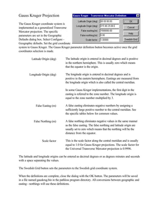
system to Gauss Kruger. The Gauss Kruger parameter definition button becomes active once the grid
coordinates selection is made.
Latitude Origin (deg) The latitude origin is entered in decimal degrees and is positive
in the northern hemisphere. This is usually zero which means
that the equator is the origin.
Longitude Origin (deg) The longitude origin is entered in decimal degrees and is
positive in the eastern hemisphere. Eastings are measured from
the longitude origin which is also called the central meridian.
In some Gauss Kruger implementations, the first digit in the
easting is referred to the zone number. The longitude origin is
equal to the zone number multiplied by 3.
False Easting (m) A false easting eliminates negative numbers by assigning a
sufficiently large positive number to the central meridian. See
the specific tables below for common values.
False Northing (m) A false northing eliminates negative values in the same manner
as the false easting. The false northing and latitude origin are
usually set to zero which means that the northing will be the
distance from the equator.
Scale factor This is the scale factor along the central meridian and is usually
equal to 1.0 for Gauss Kruger projections. The scale factor for
the Universal Transverse Mercator projection is 0.9996.
The latitude and longitude origins can be entered as decimal degrees or as degrees minutes and seconds
with a space separating the values.
The Swedish Grid button sets the parameters to the Swedish grid coordinate system.
When the definitions are complete, close the dialog with the OK button. The parameters will be saved
in a file named gauskrug.bin in the pathloss program directory. All conversions between geographic and
easting - northings will use these definitions.
2. Ellipsoid - Datum
In addition to the specified Transverse Mercator parameters, the conversion between geographic
coordinates and easting - northings are based on the ellipsoid definition. Both the Bessel and
Krassovsky ellipsoids are used. Therefore, you must select an ellipsoid and check the Use Ellipsoid
button in the Geographic defaults dialog.
Note that there is no datum cooresponding
to these two ellipsoids.
Terrain Database
The Odyssey - Gauss Kruger terrain data base option has been implemented for this projection. This
can be used with any terrain database with elevations arranged in west to east rows such as MSI
Planet. The Gauss Kruger definitions can also be set as part of the database configuration. This is same
as setting the parameters in the Geographic defaults.
A problem can occur when creating an index for a Gauss Kruger database from a text file. The east
and west edges specification can include the zone number as the first digit of the value. The conversion
process checks the value of the east and west edges. If the value is greater than 1000, the first digit is
removed. In most cases the results will be correct; however a value greater than 1000 could also be an
actual easting.
Parameters
The parameters used for the Gauss Kruger Projection in Baden-Wuerttemberg are:
spheroid Bessel 1841
latitude origin 0.0
longitude origin 9 degrees E (zone 3)
false easting (m) 3500000
false northing 0.0
scale factor 1.
In Germany, there are 5 zones using the Gauss-Kruger / Transverse Mercator projection.
zone latitude longitude scale false false spheroid
origin origin factor easting northing
degrees degrees meters meters
1 0 3E 1.0 150,000 0
2 0 6E 1.0 250,000 0
3 0 9E 1.0 350,000 0
4 0 12E 1.0 450,000 0
5 0 15E 1.0 550,000 0
3. Swedish Grid System
The Swedish grid system uses the following parameters
spheroid Bessel 1841
latitude origin 0.0
longitude origin 15º 48' 29.8" E (15.80827778 degrees E)
false easting (m) 1500000.00
false northing 0.00
scale factor 1.00
Slovakia
In Slovakia the following projections are used:
spheroid Krassovsky
latitude origin 0.0
longitude origin 15 degrees E
false easting (m) 3500000
false northing 0.0
scale factor 1.
spheroid Krassovsky
latitude origin 0.0
longitude origin 21 degrees E
false easting (m) 3500000
false northing 0.0
scale factor 1.