5.3.4 Latitude and Longitude (PLEA).docx
•Download as DOCX, PDF•
0 likes•36 views

This file is for reading

Recommended
More Related Content
Similar to 5.3.4 Latitude and Longitude (PLEA).docx
Similar to 5.3.4 Latitude and Longitude (PLEA).docx (20)
More from Diana Paola Garzón Díaz
More from Diana Paola Garzón Díaz (12)
Recently uploaded
Recently uploaded (20)
5.3.4 Latitude and Longitude (PLEA).docx
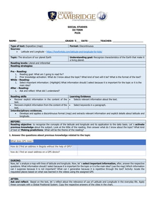
- 1. SOCIAL STUDIES III TERM PLEA NAME: _________________________________GRADE: 5___ DATE: ________TEACHER: _____________________ Type of text: Expositive (map) Format: Discontinuous Sources: Latitude and Longitude - https://howforkids.com/latitude-and-longitude-for-kids/ Topic: The structure of our planet Earth Understanding goal: Recognize characteristics of the Earth that make it a living planet. Reading levels: Literal and inferential Reading strategies: Pre - Reading: 1. Reading goal: What am I going to read for? 2. Prior knowledge activation: What do I know about the topic? What kind of text will it be? What is the format of the text? While - Reading: 1. Select important information: (Highlight) What information should I select because it is important for the topic or it is the main idea? After - Reading: 1. Ask and reflect: What did I understand? Reading skills Learning Evidence Recover explicit information in the content of the text. Selects relevant information about the text. Recovers implicit information from the content of the text. Select keywords in a paragraph. Interdisciplinary evidences. Develops and applies a discontinuous format (map) and extracts relevant information and explicit details about latitude and longitude. BEFORE: Reading objective: to recognize the concepts of the latitude and longitude and its application to the daily basis. Let´s activate previous knowledge about the subject. Look at the tittle of the reading, then answer what do I know about the topic? What kind of text is? Making predictions: What will be the theme of the reading? 1. Answer the questions about previous knowledge related to the topic What does GPS mean? How do I find an address in Bogota without the help of GPS? how do I find an exact address on a GPS device? DURING: Now, let´s analyze a map with lines of latitude and longitude. Now, let´s select important information, after, answer the respective questions. What information should I select because it is important for the topic or it is the main idea? (use the map) Which information can I suppress because it is not important? What can I generalize because it is repetitive through the text? Activity: locate the requested places based on what was learned in the videos using the assigned GPS AFTER: Ask and reflect: Based on the text, let´s reflect about the relevance of use of Latitude and Longitude in the everyday life. Apply these concepts with a Global Positional System. Copy the respective answers of the cities in the chart.