Raising, widening & strengthening with protection to scoured bank of Bedpur-K...
Hannah_s3490935_OC_Panels_2015 A
1. 2
3
4
1
1
2
3 4
WEAVE | Daniel Hannah | s3490935 | Studio 3 | Overlapping Currents | RMIT City Campus
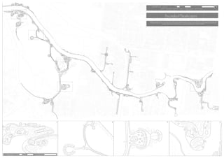
MASTER PLAN 1:3500 35m 70m 140m
Ascended Floodscapes
The design is intended to connect various systems to create a highly dynamic and changing landscape to create a more iconic Melbourne. It is intended to revitalize the popular Capital
City Trail by providing users with a unique immerse experience not found elsewhere in Victoria. The design is to utilize the large public open spaces Melbourne offers through inte-
grating the existing landscape with the Yarra river, while capturing and recycling water in a more Eco-friendly way.
SCALE 1:1000
35m
10m 20m 40m
1 2 3 4
2. 1:7500
Pathways connect the site and provides a more immersive experience to pedestrians. Different types of ground
conditions result in different materials used as walk paths. This is dependent on different factors including eleva
tion, surface and exposure to different elements.
PATHWAY PLAN
75m 150m 300m
Boardwalks are an essential part of the path
way plan as this allows users to walk over
sections of the river and floodplains without
any chance of being flooded or having direct
contact with water. These are typically at an
elevation of 2m (surface level) and run organi
cally through floodplains.
Exposed Agrigate concrete is generally used in the floodplain
due to providing a grippy surface in an area which is exposed to
flooding. This ensures pedestrian safety when walking these paths.
These are also used throughout the floodplain to keep people from
trampling vegetation. People much prefer to walk on provided paths
then trampling through boggy vegetation. Concrete is also used for
its durable nature and resistance to the elemtents
Stone tile paths are used generally on typical ground
surface level about 2m above sea level. These paths
typically run parallel to the river bank and weaves with
the design. These are used for nice aesthetic appeal
and durability. The slippery surface when wet makes it
not ideal for areas prone to high levels of water expo
sure
Just outside of the main design section of CBG, there is an
artificial wetland connected, made to completely mimic nature. In
the images below, It appears to be a collection of boulders and
stone formation connecting two sections of wetland, including
pooling sections. This is also a flooding preventative measure
by connecting two water sources.
It may come to peoples surprise to learn that this is completely
artificial, with the rocks being concrete formed and textured to
appear like rocks and boulders. This is a very effective tech
nique due to completely mimicing nature, however it provides the
flexibility to form then in any order, sequence and size possible.
This technique will be used for the lining of the floodplains and
catchment layers, acting as a firm defined boundry between layers
Image above shows a section of the 'rock shell' broken off,
revealing the concrete structure underneath. The shell is also
concrete, however textured and pigmented to look like a natural
boulder.
3. 1:7500
Catchments and water trenches are placed at different heights in prime water run off areas with the catchments
decreasing in quantity, but increasing in size as they get closer to sea level. Most storm-water is caught in the
highest catchments (up to 30m above sea level) which without escape, the water is trapped in pools littered with
dense vegetation .
CATCHMENT PLAN
75m 150m 300m
South Yarra
Residential
Housing
Richmond
Industrial
Area
Queen Victoria
Gardens/ Royal
Melbourne Bo-
tanic Gardens
The water will sit in these pools until heavy periods of rain which will make them overflow into flood channels connecting
to the lower pools. This process is repeated 1 - 4 times until reaching the floodplain, dependent on topography with
more catchments located in areas prone to higher water pollution. The floodplain catchments can be filled with either
storm water or flood water of the Yarra river, which the cycle will repeat during every flood as the water flushes out the
clean water back into the system while replacing it with Yarra water.
1
1
1
1
1
1
1
1
1
1
1
1
1
1
1
1
1
1
2
2
2
2
2
2
3
3
3
3
2
Industrial runoff
Catchment
Oil/Road pollution
Catchment
Organic material
Catchment
Residential Rooftop run-
off catchment
Heavy pollutants are caught
in these catchments such as
industrial waste, storm-water
runoff and chemicals washed
into the system from manufactur-
Catchments placed under busy
roads prone to heavy traffic,
trucks and other vehicles.
Placed underneath bridges
and busy roads to catch oils
Catchments placed at the
bottom of hills containing a lot
of trees, plants and vegetation.
Loose organic material is
flushed into these catchment
Catchments placed in residen-
tial areas to capture rooftop
runoff and other household
contaminants associated with
residential living
4. 1:7500
Various types of vegetation are used throughout the design.
Due to the design revolving around ephemeral wetlands, vegetation used in the floodplains or catchment pools need
to meet a certain criteria. Due to the salinity of the river, vegetation needs to be able to survive in salt water, as well
as fresh water.
Various trees are used in this design for various purposes. Sweet-gums and Blue Spruce trees are used as
Ornamental trees, typically on small islands where they exist purely for aesthetic appeal. Black-Box is used in the
floodplains as they can withstand heavy periods of inundation while English Elms are used primarily as river bed
liners, to continue the existing trend and ease the transition from the old design to the new.
VEGETATION PLAN
Nardoo
Marsilea Mutica
Tangled Lignum
Muehlenbeckia Florentulla
Common Reed
phragmites Australis
Cumbungi
Typha sp
Primary Trees Ornamental Trees
The 4 species listed above all share common traits such as salt/fresh water tolerant, suitable for
Melbourne climate, able to survive in seasonal wetlands and hold water filtering properties. This is
what makes these species ideal for this design. These species will be placed in floodplains and
catchment pools
75m 150m 300m
Sweetgum
Liquidambar Styraciflua
Blue Spruce
Picea Pungens
Black Box
Eucalyptus Largiflorens
English Elm
Ulmus minor 'Atinia'
The Effect:
To create a diverse and visually rich atmo-
sphere through the use of colours
5. 0 45 90 135 180 m.
Biodiversity Interactive Map A3 Landscape (c) The State of Victoria Department of Environment, Land, Water & Planning 2015
Disclaimer: This map is a snapshot generated from Victorian Government data. This material may be of assistance to you but the State of Victoria does not guarantee that the publication is without flaw of any kind or is wholly appropriate for
your particular purposes and therefore disclaims all liability for error, loss or damage which may arise from reliance upon it. All persons accessing this information should make appropriate enquiries to assess the currency of the data.
Produced on Mon Mar 23 13:50:45 EST 2015
Map Scale 1:5,000
Map created Mon Mar 23 13:50:26 EST 2015
Page 1 of 1
0 45 90 135 180 m.
Biodiversity Interactive Map A3 Landscape (c) The State of Victoria Department of Environment, Land, Water & Planning 2015
Disclaimer: This map is a snapshot generated from Victorian Government data. This material may be of assistance to you but the State of Victoria does not guarantee that the publication is without flaw of any kind or is wholly appropriate for
your particular purposes and therefore disclaims all liability for error, loss or damage which may arise from reliance upon it. All persons accessing this information should make appropriate enquiries to assess the currency of the data.
Produced on Mon Mar 23 13:50:45 EST 2015
Map Scale 1:5,000
Map created Mon Mar 23 13:50:26 EST 2015
Page 1 of 1
Wider Melbourne Surroundings
1:400000
Catchment areas and connectivity
Wider Melbourne Surroundings
1:400000
Major/Minor water ways
Wider Melbourne Surroundings
1:400000
Rainfall
Melbourne Yarra River - Pre-European wetlands
1:10000
Melbourne Yarra River - River Depth
1:10000
Melbourne Yarra River - Infrastructure
1:10000
Melbourne Yarra River - Recreational public spaces and public land
1:10000
Melbourne Yarra River - River usage plan
1:10000
Human scale - Site ground conditions and textural representation Human scale - Foot traffic congestionPathway congestion
English Elms are widely used
throughout Melbourne with a vast
amount planted as liners along
the Yarra river bed.
Topography of Melbourne Botanic
Gardens shows where the main
catchment areas would be.
The peak of the hill rises up to
40m, allowing plenty of room for
catchment interventions.
This plan shows how the River is currently used for recreational purposes. This section
of the river is a popular kayaking route which has designated turn points throughout.
The river here also sees a lot of tourist boats, generally small in size assumable due to
shallow waters and obstructions such as bridges etc.
The site contains 3 docking points which tourist boats use infrequently.
This map shows that there is a lot of open space and recreational area around
the Melbourne Botanic Gardens with little infrustructure. This makes this location
a prime place for a design due to low budget (minor destruction) and being able
to integrate an aesthetic design into an existing serene and asthetic area.
Most infrastructure is plotted on the eastern side of Morell Bridge. This
includes residential areas, industrial areas and government buildings while little
to no infrastructure lies within the Melbourne Botanic Gardens.
With each contour being less then a meter, this shows that the Yarra River is
actually quite shallow which could be to many peoples surprise. This provides a
better indication of how much water capacity the river holds, and how much water
is flowing down stream.
Image shows a rough guide of the topography around Ornamental Lake. This
provides a good indication of water runoff, and Ornamental Lake is one large
catchment.
Image shows catchment zones of
Melbourne Botanic Gardens and
how water runoff will work with
topography
Shows a simple understanding of ground conditions and a site representation of the CTT on the Western side of Morell bridge. There are a lot of open grass areas
which people use to have picnics on, lies down on and use for other means of relaxation. People tend to sit in the shade or sun Dependant on temperature. Smaller squares represent more people using the space while larger squares represents less people using the area
On a Wednesday, between 3:00pm - 3:40pm, The bike path is very popular with the vast majority of people using the site cyclists. This bike path was
used the most and far more then the footpath running parallel to the bike path, a little further away from the river. I believe people prefer to stick to the
bike path not only for convenience (as it is one long continuous track without breakage) but also due to providing a more serene atmosphere to the site.
the vast majority of people use the low bike trail (Capital City Trail) due to the nice aesthetics of being close to the river. Cyclists dominate the space at
this time with every single one using the CCT and/or Morell bridge to cross.
6. Comic strip portrays how the Yarra River has
much more then only a few uses, including the
beauty and aesthetic appeal of it. This however,
is compromised through heavy urbanization and
industrialization, stripping the Yarra river of
many values, including it's iconic nature.
"A Place to Remember"
Image on the left shows a representation of the color
contrasting of the vegetation. This picture shows a plan
tation of Liquidambar's and Blue Spruce's sitting on an
'Ornamental Island'. These Trees are used primarily for
aesthetic appeal.
Image on the right shows a lower catchment (0m above
sea level) filled with water. A tunnel is shown in the
background which allows water bodies to travel through
the landform to connect further out areas, usually
obstructed by topography.
This provides more catchment area, as catchments are
also located on the other side of the tunnel. All water
runoff caught in these catchments will be sent to the
large catchment pools displayed in the picture.
The images above show the progression of a wetland strip running parallel to the Yarra, located between floodplains. This shows how the wetlands take a life of their own and generate their own ecosystem after establishment.
This will create more natural wildlife habitats, resulting in more biodiversity and a healthier ecosystem.
This creates circular seating facing
away from the land, submerging
into the Yarra river. The tide would
determine how much seating is
available.
This design looks at creating
short tunnels connecting and
creating a more intimate expe
rience between the land and
the water. This design launched
the tunnels networking idea.
Rounded amphitheater Burrows
This design adds a path running at the level of the Yarra river, partially sub
merged which follows along under the top soil. The soil would need to be concaved
to create this open tunnel for the path, and the surface on top would need to be
reinforced.
Water level pathway
--What--
The design is to create large scale bio filtration system and ephemeral wetlands reliant on storm water run-off, and flooding of the Yarra River. The system is essentially various layers of wetland, floodplains and catchments plotted in relation to
the topography of the land to capture, filter, return floodwater and storm water back into the system. This also acts as a flood preventative measure by connecting various water sources via floodplains, to level out catchments and water bodies.