1. Callum Thurley The Richat Structure Research Proposal
Page 1 of 3
The Formation of the Richat Structure
Introduction
The Richat Structure or the “Eye of the
Sahara” is somewhat of an enigma to
geologists today. It is 40km in diameter,
and represents 3 major rings dipping
outward from the centre of the structure.
This circular feature representsan eroded
geologic dome, with sedimentary rocks of
late Proterozoic and Ordovician Age.
The Problem
The origin of theRichat Structure and the underlying magmatic body is not fully
understood, and this project main objective is to solve this. Originally it was thought
to be a meteorite impact structure, however studies undertaken by Robert S Dietz et
al 1968confirm that there aren’t any features that would commonly be associated
with “shock processes”, and therefore this cannot be an impact structure.
General Lithologies
The centre of the Richat Structure is comprised of a limestone-dolomite shelf that
encircles a large scale Breccia that was formed by Karstdissolution and collapse. Due
to the presence of neo-formed Cretaceous K-Feldspar it has been interpreted that
these sediments have a hydrothermal origin of Cretaceous age. Basaltic ring dykes,
Kimberlites, and alkaline volcanic rocks intrude and post-date these internal
sediments further suggesting that there was an alkaline magmatic body beneath the
Richat Structure (Matton et al 2005).
Current Hypothesis
The origin of the RichatStrucure
has been hypothesised as an
eroded anticlinal dome, however
its formation is not entirely
understood. It is also thought
that there is an underlying large
alkaline magmatic body, and this
project will hopefully prove or
disprove this.
The injection of an alkaline
magma occurred during the
Cretaceous period (Matton et al
2005), at this time the position of
the North Western African
continent was near to the Southern Atlantic Ocean during the oceans embryonic
stages of spreading (Figure 2). This is a rather peculiar location to find an alkaline
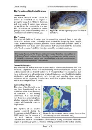
Figure 1 – An aerial photograph of the Richat
Structure.
Figure 1 – An image of the Richat Structure.
Previously the mineral Barite was misinterpreted for Coesite, a mineral that is
indicative of shock metamorphism from high velocity extraterrestrial impacts.
It probably represented a shear zone that developed in tectonic doming rather
than a meteorite impact (R.F.Fudali 1969).
Figure 2 – A continental reconstruction from the late
Cretaceous (Doucoure and de Wit 2003)
2. Callum Thurley The Richat Structure Research Proposal
Page 2 of 3
magma, because alkali magmas are usually associated with continental rift systems
such as in East Africa, however there isn’t a rift system in close proximity to the
Richat Structure. The Injection of this alkaline magma may have occurred due to the
extension and thinning of the crust near Mauritania.. It has been hypothesised that
the magmatism may be attributed to a mantle plume, heating the base of this thinned
crust (Collins 2011)These two factors combined together are the most likely cause of
continental alkali magmatism. The opening of the Atlantic has been attributed to
plume activity and lead to the formation of the Peri-Atlantic Alkaline Province where
the Richat Structure is located (Matton 2008). The presence of Kimberlites is not
surprising, due to the fact that some of the oldest crust in the world is located in the
western African Craton, a typical tectonic setting for Kimberlites. Finally it may have
been the upwelling of this magma that caused up warping and doming of the
overlying sediments. This can be inferred because there is not any kind of
convergent plate boundary in close proximity to produce fold tectonically.
This Project and Methodology
The proposed drilling site for thisproject is at the centre of the structure (as seen
above in Figure 3) at the approximate GPS co-ordinates of 21°07’30” N, 11°24’00”
W.This project plans to drill a borehole approximately 20km into the structure to
penetrate into the magmatic body below(Matton 2008). Enabling us to identify
exactly what the source of the ring dykes are by geochemical analysis, such as the
LREE, HREE, LILE, and incompatible elemental compositions of the magmatic body.
This may also
unearth data that has
not previously been
seen, such as the
subsurface
lithologies. It will
either confirm or
disprove the
presence of a
subsurface intrusion
and identify its
source. Furthermore,
we can compare the
composition of the
alkali magma with
that of other magmas
Figure 3 – A photograph showing the proposed drilling site. (Google Earth Copyright
2013)
Figure 4 – Cross Section of the Richat Structure (Matton)
2008)
3. Callum Thurley The Richat Structure Research Proposal
Page 3 of 3
that have identified sources. This data can then be correlated with the rocks brought
up from within the borehole.Elemental similarities between these samples and other
igneous rocks with known sources can be identified and interpreted.
Geophysical Data
Shallow and deep seismic profiling will have to be carried out here. Both of these
datasets will becorrelated with borehole lithological data to work out an accurate
cross section. This will enable us to have a deeper understanding of the subsurface
geology, and ultimately it will allow us to understand the processes of its formation.
If possible three dimensional profiling of the crust here would be perfect because it
would give us a further insight into the details of structures below the Richat
Structure. A Magnetic survey could be carried out, which would be useful because
the minerals within the igneous rocks would have a higher magnetic signal than that
of the country rock. Therefore this would give us some indication of where to drill. A
gravity survey will also be carried out, due to the fact that the intruded igneous rocks
would have a higher specific gravity than the country rock, therefore giving more
detail about the location of the magmatic body.
Problems
A Possible problem with the project is that the magmatic body may not be
directly below the centre of structure itself, and so drilling may not enable us
to locate the source of the igneous lithologies.Doing the initialgeophysical
survey and then drilling would solve this.
Conditions in the Sahara may provide some issues, mainly the temperature
would be an issue, where in the summer the temperature regularly exceeds
50°C. This could lead to dehydration of the research scientists, however very
simply always carry sufficient water, or just carrying out the research in the
winter months could solve this.
References
1. Collins, S 2012, Balance sheets, lecture notes distributed in Igneous and
Metamorphic Geochemistry and Petrology, at The University of Durham,
2012.
2. Richat and Semsiyat Domes (Mauritania): Not Astroblemes, Robert S Dietz,
Robert Fudali, and William Casidy, December 1968. doi: 10.1130/ 0016-7606, v.
80 no. 7 p. 1367-1372
3. Old inherited origin for the present near-bimodal topography of Africa,
C.MoctarDoucouré, Maarten J. de Wit, Volume 36, Issue 4, May 2003, Pages
371–388.
4. Coesite from the Richat Dome, Mauritania: A Misinterpretation, R.F.Fudali,
10th
October1969, vol-166, no.3902, pp 228-30
5. Google Earth Copyright 2013.
6. Jones and Bartlett. Boston. Winter (2001) An Introduction to Igneous and
Metamorphic Petrology. Prentice Hall.
7. Resolving the Richat enigma: Doming and hydrothermal karstification above an
alkaline complex , Guillaume Matton, Michel Jebrak and James K.W.Lee,
2005.doi: 10.1130/G21542AR.1, v. 33 no. 8 p. 665-668
8. The Cretaceous Complex of Richat (Mauritania); A Peri-Atlantic Alkaline
Process,,GuillaumeMatton 2008,
If the rocks have a chemical signature that is enriched in incompatible elements,
then we can confirm that it has a deeper mantle source, similar to that of OIB.