1. Among the other features mapped by the SCA Army Corps of Engineers GIS Mapping Team, parking areas provide yet
another way in which we assisted the U.S. Army Corps of Engineers (USACE) in cataloging their assets in a GIS. However,
collecting data for parking areas had unique challenges and opportunities that differentiated it from point or line data collection.
Eastman Lake Parking Areas: Data Collection and Results
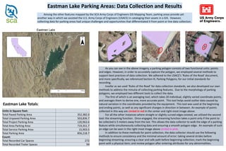
As you can see in the above imagery, a parking polygon consists of two functional units: points
and edges. However, in order to accurately capture the polygon, we employed several methods to
support best practices of data collection. We adhered to the USACE’s ‘Rules of the Road’ document,
and more specifically, we referenced Section III, Parking Polygons, for our initial standards for
recording.
Insofar as we used ‘Rules of the Road’ for data collection standards, we also developed our own
methods to address the minutia of collecting parking features. Due to the morphology of parking
polygons, we employed two different tools to collect the data.
The first of which is an averaging tool, which takes 20 individual, slightly varied coordinate points,
and averages them to derive one, more accurate point. This tool helps avoid outlier data caused by
natural variation in the coordinates provided by the equipment. This tool was used at the beginning
and ending points, as well as any significant changes in direction in between. An example of points
collected in this way are circled in red in the center and right-most image above.
For all the other instances where straight or slightly curved edges existed, we utilized the second
tool: the streaming function. Once engaged, the streaming function takes a point only if the point to
be collected is 5 meters away from the last. This allows the data collector to walk the edge of a parking
feature while simultaneously collecting data and ensuring a smooth polygon edge. An example of such
an edge can be seen in the right-most image above circled in pink.
In addition to these methods for point collection, the data collector should use the following
methods to ensure consistency and the minimal amount of error: taking several strides before
beginning streaming; ensuring a clear and safe path before beginning collection; mark the beginning
point with a physical item; and review polygon after entering attributes for any abnormalities.
Units in Square Feet:
Total Paved Parking Area 352,382.0
Total Unpaved Parking Area 503,836.7
Total Project Parking Area 120,963.6
Total Area Parking Area 719,351.7
Total Service Parking Area 15,903.5
Total Parking Area 856,218.7
Count:
Total Recorded Car Spaces 272
Total Recorded Trailer Spaces 94
Eastman Lake Totals: