Jual Total Station Sokkia CX-101 Call Fery 087885028163
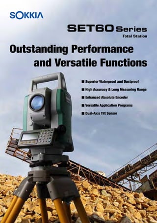
Set60 e
1. Outstanding Performance
and Versatile Functions
Total Station
SET60Series
n Superior Waterproof and Dustproof
n High Accuracy & Long Measuring Range
n Enhanced Absolute Encoder
n Versatile Application Programs
n Dual-Axis Tilt Sensor
2. Outstanding Performance and
nExtra-large memory capacity for 24,000 points
SET60 Series store the measured data up to 24,000 points.
Circular level for
easy check
Data exchange with
PC via RS-232C port
Detachable handle ergonomically
designed for easy gripping
Clear and bright telescope
Magnification: 30x
Minimum focus: 1.3m
Instrument
center mark
Optical plummet
Magnification: 3x
Precise leveling by
a highly sensitive
plate level
Easy-to-use 10-key pads
with alphabet entry on
both faces
Lock and fine
adjustment
tangent screw
Easy viewing displays
with 4-line, 20-character,
with backlight and heater
on both faces
Integrated tribrach with
quick lock/ release
feature
Rechargeable Battery
(BT-G1S)
Rough but quick
capture of prism by
sighting collimator
Telescope grip that
enables subtle
adjustment
3. Versatile Functions
nSuperior Waterproof and Dustproof
SET60 series conform to IEC Standard IP54. No worry about
sudden bad weather.
Versatile Application Functions
On-board data collection, Survey, Layout, Road Calculation, and
many more functions.
nHigh Accuracy & Long Measuring Range
• High accuracy: ±(2mm + 2ppm x D)m.s.e.
• Long distance: 2,000m with a Single Prism.
nEnhanced Absolute Encoder
SET60 Series adopted an absolute encoder system, which
doesn't require 0 set and realizes stable measurement with
less reading error.
nDual-axis tilt sensor
The dual-axis tilt sensor monitors inclination of both X and
Y axes, and correct horizontal and vertical angle readings
automatically.
54The International Electrotechnical Commission standard IEC 60529 describes a system
for classifying degrees of protection provided by enclosures of electrical equipment.
The IP Code consists of the letters IP and two numerals. Larger numbers represent
greater levels of protection.
Protection against ingress of
solid foreign objects
Highest level: 6
Protection against ingress of
water
Highest level: 8
7 levels: 0 to 6.
X: unspecified.
9 levels: 0 to 8.
X: unspecified.
• Remote Elevation Measurement (R.E.M.)
To easily determine the height of a point where a prism
cannot be placed. Take a distance to a prism placed either
directly above or directly below the target point, then sight to
the target point.
• Layout
Layout function for coordinate measurement and control
stakeout and resection measurements.
• Road
Road function
automatically calculates
parameters of a
complicated spiral curve
and a long distance route
simply by defining the
start point, end point and
curve elements.
• Missing Line Measurement (M.L.M.)
To measure horizontal distance, slope distance and height
difference between two prisms.
H
S
V
H
S
V
H
S
V
H
S
V
H
N
Z
E
Front View
Inclined
Horizontal Plane
True
Horizontal Plane
Inclined Instrument
Axis
True Perpendicular
Axis
Side View
Inclined
Horizontal Plane
True
Horizontal Plane
Inclined Instrument
Axis
True Perpendicular
Axis
Measuring range
2,000m900m
Single Prism
Mini Prism