Total Station Sokkia IM 101 Accuracy 1 Reflectorles 1000 Meter

Kami menjual alat survey. Kami disini sebagai supplier alat survey tanah atau bangunan, alat survey telekomunikasi, alat survey geologi atau mining, dan alat survey lainnya diantaranya Total Station, Digital Theodolite, Automatic Level, GPS, Kompas, Binoculars, Monocullars, Laser Rangefinder, Teropong Malam, Digital Altimeter, Clinometer, Tandem, Digital Planimeter, Distometer, Speed Gun, Measuring Wheel, Measuring Tape, Grounding Tester, HT Handy Talky, Sound Level Meter, dan alat alat Geologi. Ditunjang dengan merk merk yang sudah terkenal dan telah diakui keberadaanya didunia survey diantaranya Topcon, Nikon, Sokkia, Garmin, Trimble, Magellan, Suunto, Horizon, Bushnell, Brunton , Leica, Bosch, South, Yamayo, Tajima, Icom, Kyoritsu, dll. Semoga keberadan kami dapat menjawab sekaligus memenuhi kebutuhan alat survey yang keberadaannya sangat dibutuhkan pada era perkembangan pembangunan dan tekhnologi pada saat ini. Cara Order: Alat Alat Tersebut, 1. Telpon Atau SMS ke Nama: Saepuloh 0877 8398 9463 (Pro XL) 0857 9749 5084 (Indosat) email : saepuloh.1809@yahoo.com

Recommended
Recommended
More Related Content
What's hot
Similar to Total Station Sokkia IM 101 Accuracy 1 Reflectorles 1000 Meter
Similar to Total Station Sokkia IM 101 Accuracy 1 Reflectorles 1000 Meter (20)
Recently uploaded
Recently uploaded (20)
Total Station Sokkia IM 101 Accuracy 1 Reflectorles 1000 Meter
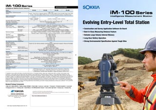
- 1. iM-100 Series Evolving Entry-Level Total Station intelligence Measurement Station iM-100 Series SPECIFICATIONS - Bluetooth® word mark and logos are registered trademarks owned by Bluetooth SIG, Inc. and any use of such marks by Topcon is under license. - Other trademarks and trade names are those of their respective owners. - Specifications may vary by region and are subject to change without notice. TOPCON CORPORATION 75-1 Hasunuma-cho, Itabashi-ku, Tokyo 174-8580, Japan Phone: (+81)3-3558-2993 Fax: (+81)3-3960-4214 www.topcon.co.jp Your local Authorized Dealer is: ©2017 Topcon Corporation All rights reserved. P-234-1 GE intelligence Measurement Station • Main unit • Battery (BDC70) • Battery charger (CDC68A) • Power Cable • Lens cap • Lens hood • Tool pouch • Precision Screwdriver • Lens brush • Hexagonal wrench ×2 • Cleaning cloth • Quick Manual • CD-ROM (Operation manual) • Laser caution sign-board • Carrying case • Carrying strap Standard Package Components • Construction and Survey Application Software On Board • Best-in-Class Measuring Distance Feature • Reliable Large Volume Internal Memory • Long-Hour Battery Operation • Strong Environmental Specification Against Tough Sites Model iM-101 iM-102 iM-103 iM-105 Telescope Magnification / Resolving power 30x / 2.5" Others Length : 171mm (6.7in.), Objective aperture : 45mm (1.8in.) (48mm (1.9in.) for EDM), Image: Erect, Field of view: 1°30' (26m/1,000m), Minimum focus: 1.3m (4.3ft.) Reticle illumination: 5 brightness levels Angle measurement Minimum Display 0.5"/1" (0.0001 / 0.0002gon, 0.002 / 0.005mil) 1"/5" (0.0002 / 0.001gon, 0.005 / 0.02mil) Accuracy (ISO 17123-3:2001) 1" 2" 3" 5" Dual-axis compensator Dual-axis liquid tilt sensor, working range: ±6' Collimation compensation On/Off (selectable) Distance measurement Laser output *1 Reflectorless mode : Class 3R / Prism/sheet mode : Class 1 Measuring range Reflectorless *3 0.3 to 800m (2,620ft.) / Under good conditions *4 : 1,000m (3,280ft.) (under average conditions *2 ) Reflective sheet *5*6 RS90N-K: 1.3 to 500m (4.3 to 1,640ft.), RS50N-K: 1.3 to 300m (4.3 to 980ft.), RS10N-K: 1.3 to 100m (4.3 to 320ft.) Mini prisms CP01: 1.3 to 2,500m (4.3 to 8,200ft.), OR1PA: 1.3 to 500m (4.3 to 1,640ft.) One prism 1.3 to 5,000m (4.3 to 16,400ft.) / Under good conditions *4 : 6,000m (19,680ft.) Minimum Display Fine / Rapid : 0.0001m (0.001ft. / 1/16 in.) / 0.001m (0.005ft. / 1/8 in.) (selectable) Tracking / Road : 0.001m (0.005ft. / 1/8 in.) / 0.01m (0.02ft. / 1/2 in.) (selectable) Accuracy *2 Reflectorless *3 (2 + 2ppm x D) mm *8 (ISO 17123-4:2001) Reflective sheet *5*6 (2 + 2ppm x D) mm (D=measuring distance in mm) Prism *7 (1.5 + 2ppm x D) mm Measuring time *4*9 Fine 0.9s (initial 1.5s) Rapid 0.6s (initial 1.3s) Tracking 0.4s (initial 1.3s) OS, Interface and Data management Operating system Linux Display / Keyboard Graphic LCD, 192 x 80 dots, backlight, contrast adjustment / Alphanumeric keyboard / 28 keys with backlight Control panel location On both faces Trigger key Yes (right side) Data storage Internal memory Approx. 50,000 points Plug-in memory device USB flash memory (max. 32GB) Interface Serial RS-232C, USB2.0 (Type A for USB flash memory) Bluetooth modem (option) *10 Bluetooth Class 1.5, Operating range: up to 10m *11 General Guide light *12 Green LED (524nm) and Red LED (626nm), Operating range: 1.3 to 150m (4.3 to 490ft.) Laser-pointer *12 Coaxial red laser using EDM beam Levels Graphic 6’ (Inner Circle) Circular level (on tribrach) 10' / 2mm Plummet Optical Magnification: 3x, Minimum focus: 0.5m (19.7in.) from tribrach bottom Laser (option) Red laser diode (635nm±10nm), Beam accuracy: <=1.0mm@1.3m, Class 2 laser product Dust and water protection / Operating temperature IP66 (IEC 60529:2001) / -20 to +60ºC (-4 to +140ºF) Size with handle 183(W)x 181(D)x 348(H)mm Instrument height 192.5mm from tribrach mounting surface Weight with battery & tribrach Approx. 5.3kg (11.7lb) Power supply Battery Li-ion rechargeable battery BDC70 Operating time (20ºC) *13 BDC70: Approx. 28hours *14 Application program On board • REM Measurement • 3D Coordinate Measurement • Resection • Stake Out • Topography Observation • Offset Measurement • Missing Line Measurement • Intersection • Surface Area Calculation • Route Surveying • Point to Line *1 IEC60825-1:Ed.2.0:2007/ FDA CDRH 21 CFR Part 1040.10 and 11 *2 Average conditions: Slight haze, visibility about 20km (12 miles), sunny periods, weak scintillation. *3 With Kodak Gray Card White Side (90% reflective). When brightness on measured surface is 30,000 lx. or less. Reflectorless range/accuracy may vary according to measuring objects, observation situations and environmental conditions. *4 Good conditions: No haze, visibility about 40km (25miles), overcast, no scintillation. *5 When the measuring beam’s incidence angle is within 30º in relation to the reflective sheet target. *6 Measuring range in temperatures of 50 to 60°C (122 to 140°F): RS90N-K: 1.3 to 300m (4.3 to 980ft.), RS50N-K: 1.3 to 180m (4.3 to 590ft.), RS10N-K: 1.3 to 60m (4.3 to 190ft.) *7 Face the prism toward the instrument during the measurement with the distance at 10 m or less. *8 Measuring range:0.3 to 200m *9 Fastest time under good conditions, no compensation, EDM ALC at appropriate setting, slope distance. *10 Usage approval of Bluetooth wireless technology varies according to country. Please consult your local office or representative in advance. *11 No obstacles, few vehicles or sources of radio emissions/interference in the near vicinity of the instrument, no rain. *12 The laser-pointer and the guide light do not work simultaneously. *13 Figures will change depensing on the operating environment including temperatures and observation conditions. *14 In use of ECO mode. Fine single measurement every 30sec.
- 2. Newly Designed High-End Class EDM Reliable Large Volume Memory Accuracy Measuring Range Prism-Mode 1.5mm+2ppm 6,000m* Reflectorless 2.0mm+2ppm 1,000m* All Features are at Top Class Especially effective in surveying control points that require high-accuracy, and in cross sectional surveying in large areas with reflectorless measurement mode. Internal memory has 50,000 points to record. USB memory can be used up to 32GB. iM Previous Model Previous Model 1,000m1,000m 1.5mm+2ppm1.5mm+2ppm 2.0mm+2ppm 500m iM Distance Measurement Accuracy(Prism Mode) Measuring Range(Reflectorless Mode) Distance Accuracy iM Previous Model 1.5mm+2ppm1.5mm+2ppm 2.0mm+2ppm 500m iM Distance Measurement Accuracy (Prism Mode) Measuring Range(Reflectorless Mode) Accuracy 1,000m1,000m Distance Previous Model * Good atmospheric condition • Remotely update the firmware via the internet • Improves asset management by checking TS operating time • Remote Lock secures the instrument from theft. • Monitor TS heath status to enable quick reaction against any functionality issues TSshield IoT Support System IoT Support System - Connect the Site and the Office IoT *This service may not be available in same areas. Construction A B C D E Survey Construction and Survey Application Software On Board Reliable All-Round Total Station Superior Basic Feature will Expand Your Application Japan Quality Products Strong Environmental Spec Bright Illumination Key for Nighttime Work Reliable Large Volume Memory Long Hours Operation Improve Topography and Stake Out, with features to achieve faster and more efficient workflows The IP66 rating ensures durability for most any rough job site temperatures and conditions. We perform the tough environmental tests to ensure long-term operation even under the rough site environments. iM Series total stations are thoroughly inspected with dust-proof and water-proof test chambers. In addition, the various tests against vibration, drop, temperature, and humidity were successfully passed to achieve the best environmental spec. Also, the measuring distance accuracy test on base line and the instrument leveling and angle accuracy test and adjustment by collimator system ensure your satisfaction on iM Series product quality. Key buttons are illuminated to minimize mistakes. Internal memory has 50,000 points to record. USB memory can be used up to 32GB. One battery lasts up to 28 hours, or about four days of normal operation time. By using the MLM (Missing Line Measurement) program, the height difference between points can be calculated. Also, you can save time on reflectorless mode to measure a number of points of variation in a large area. The Guide Light function will navigate the prism operator to move to the stake out line quickly so that stake out operation can be done effectively. Staking out with 3D coordinates, eliminates the need to set up TS on the straight line for all elevation stakes. By using the Area function, you can calculate the area easily. Also, you can determine the center point of the column such as electric pole, which cannot be directly measured, by using offset calculation. With coordinate measurement, you can manage 3D coordinate data so that various calculations such as Road, Layout and more can be determined. 3D coordinate data management can improve the productivity drastically. The trigger key, or measuring distance key, helps you perform topography quickly while continuously viewing through the telescope. Also, the long distance measuring range reduces the number of the instrument changes for more efficient working time. Topographic Survey Elevation Stake Cross-Sectional Survey Stake Out Coordinate Measurement Boundary and Cadastral Survey iM