Planning Studio- Amritsar.pptx
•Download as PPTX, PDF•
0 likes•1 view
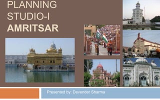
This document provides details of the land use plan for Amritsar, India. It summarizes the existing land use patterns and population statistics for Amritsar as of 2001 and projected for 2031. It notes some gaps in the current land use such as poor maintenance of heritage areas, scarcity of recreational areas, and insufficient parking. The document outlines that future growth directions for Amritsar will be toward the airport to the northwest and toward the Jalandhar Road to the southeast.
Report
Share
Report
Share

Recommended
Recommended
More Related Content
Recently uploaded
Recently uploaded (20)
M3M The Line Brochure - Premium Investment Opportunity for Commercial Ventures
M3M The Line Brochure - Premium Investment Opportunity for Commercial Ventures
Enjoy Night ≽ 8448380779 ≼ Call Girls In Iffco Chowk (Gurgaon)
Enjoy Night ≽ 8448380779 ≼ Call Girls In Iffco Chowk (Gurgaon)
The Gale at Godrej Park World Hinjewadi Pune Brochure.pdf
The Gale at Godrej Park World Hinjewadi Pune Brochure.pdf
9990771857 Call Girls in Dwarka Sector 2 Delhi (Call Girls) Delhi
9990771857 Call Girls in Dwarka Sector 2 Delhi (Call Girls) Delhi
Best Deal Virtual Space in Satya The Hive Tata Zudio 750 Sqft 1.89 Cr All inc...
Best Deal Virtual Space in Satya The Hive Tata Zudio 750 Sqft 1.89 Cr All inc...
BPTP THE AMAARIO For The Royals Of Tomorrow in Sector 37D Gurgaon Dwarka Expr...
BPTP THE AMAARIO For The Royals Of Tomorrow in Sector 37D Gurgaon Dwarka Expr...
9990771857 Call Girls Dwarka Sector 9 Delhi (Call Girls ) Delhi
9990771857 Call Girls Dwarka Sector 9 Delhi (Call Girls ) Delhi
9990771857 Call Girls in Dwarka Sector 137 Noida (Call Girls) Delhi
9990771857 Call Girls in Dwarka Sector 137 Noida (Call Girls) Delhi
9990771857 Call Girls in Dwarka Sector 1 Delhi (Call Girls) Delhi
9990771857 Call Girls in Dwarka Sector 1 Delhi (Call Girls) Delhi
Call Girls in Karkardooma Delhi +91 84487779280}Woman Seeking Man in Delhi NCR
Call Girls in Karkardooma Delhi +91 84487779280}Woman Seeking Man in Delhi NCR
2k Shots ≽ 9205541914 ≼ Call Girls In Sainik Farm (Delhi)
2k Shots ≽ 9205541914 ≼ Call Girls In Sainik Farm (Delhi)
Shapoorji Pallonji Joyville Vista Pune | Spend Your Family Time Together
Shapoorji Pallonji Joyville Vista Pune | Spend Your Family Time Together
TENANT SCREENING REPORT SERVICES How Tenant Screening Reports Work
TENANT SCREENING REPORT SERVICES How Tenant Screening Reports Work
Call Girls In Krishna Nagar Delhi (Escort)↫8447779280↬@SHOT 1500- NIGHT 5500→...
Call Girls In Krishna Nagar Delhi (Escort)↫8447779280↬@SHOT 1500- NIGHT 5500→...
Featured
More than Just Lines on a Map: Best Practices for U.S Bike Routes
This session highlights best practices and lessons learned for U.S. Bike Route System designation, as well as how and why these routes should be integrated into bicycle planning at the local and regional level.
Presenters:
Presenter: Kevin Luecke Toole Design Group
Co-Presenter: Virginia Sullivan Adventure Cycling AssociationMore than Just Lines on a Map: Best Practices for U.S Bike Routes
More than Just Lines on a Map: Best Practices for U.S Bike RoutesProject for Public Spaces & National Center for Biking and Walking
Featured (20)
Content Methodology: A Best Practices Report (Webinar)
Content Methodology: A Best Practices Report (Webinar)
How to Prepare For a Successful Job Search for 2024
How to Prepare For a Successful Job Search for 2024
Social Media Marketing Trends 2024 // The Global Indie Insights
Social Media Marketing Trends 2024 // The Global Indie Insights
Trends In Paid Search: Navigating The Digital Landscape In 2024
Trends In Paid Search: Navigating The Digital Landscape In 2024
5 Public speaking tips from TED - Visualized summary
5 Public speaking tips from TED - Visualized summary
Google's Just Not That Into You: Understanding Core Updates & Search Intent
Google's Just Not That Into You: Understanding Core Updates & Search Intent
The six step guide to practical project management
The six step guide to practical project management
Beginners Guide to TikTok for Search - Rachel Pearson - We are Tilt __ Bright...
Beginners Guide to TikTok for Search - Rachel Pearson - We are Tilt __ Bright...
Unlocking the Power of ChatGPT and AI in Testing - A Real-World Look, present...
Unlocking the Power of ChatGPT and AI in Testing - A Real-World Look, present...
More than Just Lines on a Map: Best Practices for U.S Bike Routes
More than Just Lines on a Map: Best Practices for U.S Bike Routes
Ride the Storm: Navigating Through Unstable Periods / Katerina Rudko (Belka G...
Ride the Storm: Navigating Through Unstable Periods / Katerina Rudko (Belka G...
Planning Studio- Amritsar.pptx
- 2. Detail of Amritsar LPA Notified on 18th July, 2007 Area 1,39,419 hectares Population (2001 census) 16,60,466 Projected population (2031) 30,17,936 Existing urbanisable area (2001) 9660.27 hectares Proposed urbanisable area (2031) 17,210 hectares Comprises of MC Amritsar, four urban settlements and 310 Rural settlements Note LPA Amritsar comprises of 52.67% of the area and 76.98% of the population of Amritsar district
- 4. Detail of existing land use (2010) and proposed land use (2031) Sr. no. Type of Land Use % of developed area (2010) % of proposed developed area (2031) Requirement as per URDPFI Guidelines (for large cities) 1 Residential 51.74 43 36-39 2 Commercial 4.72 5 5-6 3 Industrial 5.35 11 7-8 4 Public and Semi Public 20.04 5 Government 11 10-12 6 Utilities and Services 7 Recreational 1.50 15 14-16 8 Traffic and
- 5. Gaps in the existing landuse Poor maintenance of heritage areas especially being a historical city Scarcity of Recreational areas Insufficient parking Lack of direct connectivity between major places of the city e.g. walled city, Airport.
- 6. Direction of growth Towards the Airport (Ajnala Road in the North-West Direction) Towards Jalandhar Road in the south east direction