Ride the Storm: Navigating Through Unstable Periods / Katerina Rudko (Belka G...
Allerta010 2019
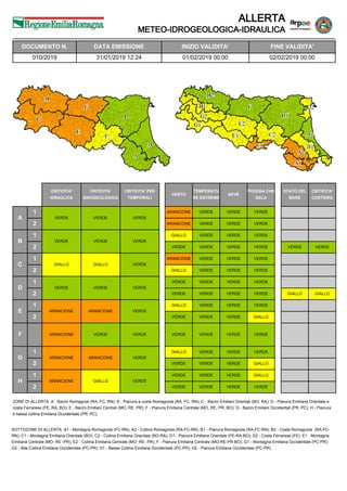
1. ALLERTA
METEO-IDROGEOLOGICA-IDRAULICA
A
1
2
CRITICITA'
IDRAULICA
CRITICITA'
IDROGEOLOGICA
CRITICITA' PER
TEMPORALI
VENTO
TEMPERATU
RE ESTREME
NEVE
PIOGGIA CHE
GELA
STATO DEL
MARE
CRITICITA'
COSTIERA
VERDE VERDE VERDE
ARANCIONE VERDE VERDE VERDE
VERDEARANCIONE VERDEVERDE
VERDE
VERDE
GIALLO
VERDE
VERDE
VERDE
VERDE
VERDE
VERDEVERDE VERDE
VERDEVERDE
VERDE
GIALLO
ARANCIONE
GIALLO
VERDE
VERDEGIALLO
VERDE VERDE
VERDEVERDE
VERDE
VERDE
VERDE
VERDE
VERDE
VERDE
GIALLO
VERDE
GIALLOVERDE VERDE
VERDEVERDE
VERDE
ARANCIONE
GIALLO
VERDE
VERDE
VERDEARANCIONE
VERDE GIALLO
VERDEVERDE
ARANCIONE VERDE VERDEVERDEVERDE VERDEVERDE
VERDE
ARANCIONE
GIALLO
VERDE
VERDE
VERDEARANCIONE
VERDE GIALLO
VERDEVERDE
VERDE
ARANCIONE
VERDE
VERDE
VERDE
VERDEGIALLO
VERDE VERDE
GIALLOVERDE
B
2
1
C
2
1
D
2
1
E
2
1
F
G
2
1
H
2
1
ZONE DI ALLERTA: A - Bacini Romagnoli (RA, FC, RN); B - Pianura e costa Romagnola (RA, FC, RN); C - Bacini Emiliani Orientali (BO, RA); D - Pianura Emiliana Orientale e
costa Ferrarese (FE, RA, BO); E - Bacini Emiliani Centrali (MO, RE, PR); F - Pianura Emiliana Centrale (MO, RE, PR, BO); G - Bacini Emiliani Occidentali (PR, PC); H - Pianura
e bassa collina Emiliana Occidentale (PR, PC).
SOTTOZONE DI ALLERTA: A1 - Montagna Romagnola (FC-RN); A2 - Collina Romagnola (RA-FC-RN); B1 - Pianura Romagnola (RA-FC-RN); B2 - Costa Romagnola (RA-FC-
RN); C1 - Montagna Emiliana Orientale (BO); C2 - Collina Emiliana Orientale (BO-RA); D1 - Pianura Emiliana Orientale (FE-RA-BO); D2 - Costa Ferrarese (FE); E1 - Montagna
Emiliana Centrale (MO- RE -PR); E2 - Collina Emiliana Centrale (MO- RE- PR); F - Pianura Emiliana Centrale (MO-RE-PR-BO); G1 - Montagna Emiliana Occidentale (PC-PR);
G2 - Alta Collina Emiliana Occidentale (PC-PR); H1 - Bassa Collina Emiliana Occidentale (PC-PR); H2 - Pianura Emiliana Occidentale (PC-PR).
DATA EMISSIONE INIZIO VALIDITA' FINE VALIDITA'
010/2019 31/01/2019 12:24 01/02/2019 00:00 02/02/2019 00:00
DOCUMENTO N.
2. ALLERTA
METEO-IDROGEOLOGICA-IDRAULICA
DESCRIZIONE DEI FENOMENI
Per venerdì 1 febbraio sono previste piogge di intensità elevata sui settori appenninici centro occidentali con possibilità di
rovesci temporaleschi e parziale fusione del manto nevoso preesistente. Nella mattinata non si escludono anche fenomeni
di pioggia che gela nelle valli appenniniche più interne tra il piacentino e il modenese, mentre nella pianura piacentina si
prevedono fenomeni di pioggia mista a neve e pioggia dal pomeriggio. Sui settori appenninici centro-orientali si prevedono
nella seconda parte della giornata raffiche di vento superiori a 90 km/h (intensità media 75-88 km/h); sul settore
occidentale sono previste raffiche superiori a 74 km/h (intensità media 62-74 km/h). Il mare sarà molto mosso localmente
agitato al largo della costa ferrarese in tarda serata, con possibili fenomeni di ingressione marina nella costa ferrarese.
Tendenza nelle successive 48 ore: intensificazione attenuazione in esaurimentostazionarietà
NOTE
Per approfondimenti sul contenuto del presente documento e la consultazione dei dati in tempo reale:
https://allertameteo.regione.emilia-romagna.it
Per ulteriori informazioni di carattere meteorologico:
Centro Funzionale Regione Emilia Romagna – Arpae Servizio Idro-Meteo-Clima
https://www.arpae.it/sim/
tel: 051 649 7600 (segreteria telefonica previsioni)
email: centrofunzionalerer@arpae.it
pec: centrofunzionale.emilia-romagna@cert.arpa.emr.it
Per ulteriori informazioni di protezione civile:
Agenzia per la sicurezza territoriale e la protezione civile – Emilia Romagna
http://protezionecivile.regione.emilia-romagna.it/
Centro Operativo Regionale lun. - sab. 08:00-20:00 - 051 527 4440/4200
Centralino Agenzia regionale attivo H24 - 051 527 4404
email: procivcor@regione.emilia-romagna.it
RIFERIMENTI E CONTATTI
IL DIRIGENTE REFERENTE CENTRO FUNZIONALE
Sandro Nanni Gabriele Alifraco
PER IL DIRETTORE
AGENZIA REGIONALE PER LA SICUREZZA
TERRITORIALE E LA PROTEZIONE CIVILE
Firma autografa omessa ai sensi dell'art.3, c.2, D.Lgs.
12/02/1993, n.39
Firma autografa omessa ai sensi dell'art.3, c.2, D.Lgs.
12/02/1993, n.39