1 How to Overcome Public Perception Issues on Potable R.docx
SeniorDesign
1. BACKGROUND
PROTOTYPE
TESTING
DESIGN REQUIREMENTS
SOLUTION
RESULTS
The Lakeview Estates Lake Association (LELA) is a
neighborhood waterfront nonprofit corporation
operating in Lexington, Kentucky, situated near
Richmond Road in central Fayette County. LELA is
responsible for two reservoirs in the West
Hickman watershed, Lake Hickman and Lake
Fontaine, which has a contributing drainage area
of about 2,800 acres. The area is densely
populated and is surrounded by significant urban
infrastructure including Southland Christian
Church and subdivisions with heavy traffic
throughout. The residents surrounding the
reservoirs use the water for a variety of
recreational activities: boating, fishing, and
swimming. Concerns about lake health prompted
LELA to solicit help for a water quality monitoring
and assessment plant. In addition, board
members welcomed any solutions to mitigate
harmful effects of the surrounding urban
environment.
LELA Water Quality Monitoring and
Assessment Plan: Team Stagnum
LELA members requested a method for compiling
historical data with newly and consistently
acquired data. Also mentioned: a method of
determining and distributing any water quality
advisories from an easily accessible medium.
Testing was performed from July to mid-October of 2016 as a
precursor to formulation. The determination of present water
quality conditions included the following parameters: E. coli,
dissolved oxygen (DO), nitrates, turbidity, ammonium, chloride, pH,
total suspended solids (TSS), and conductivity. All tests, except for
DO, were taken bi-weekly at nine different outfalls across the
reservoirs. It was determined that a website would be the most
accessible method of communication for the advisories. A simple
indicator on the website would convey current conditions and any
safety concerns. Also, a settling vault was selected as a way to
lessen suspended water pollutants.
Water at three outfalls was determined to be in worse
condition than at others after all testing was finished
and analyzed. The wet vault slowed the velocity of
incoming water and allowed particulates to settle
before the water continued downstream. The website
was running and functional at the end of the
semester, but resident feedback has not been
collected.
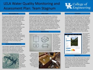
Left: CAD drawings of
the wet vault. An
entrance from a
culvert attached to
one side of the vault.
An exit leading to the
reservoir was offset at
a lower elevation so
water flowing through
the vault could slow
and suspended
pollutants could settle.
Theoretically the top
of the vault could be
used as a viewing
area, fishing platform,
etc.
Right: the wet vault
was tested in the lab
and produced favorable
results. The prototype
was to scale for a
smaller culvert but
could be enlarged to be
adapted to some of the
larger culverts on the
reservoir. Some of
these culverts are large
in size and responsible
for drainage a large
surface area
Left: Satellite
imagery of the
two culverts (two
furthest right).
Dense urban
sprawl can be
seen surrounding
the reservoirs.
Many water
quality
parameters are
affected by the
surrounding land
use.
The website was completed at the end of the semester
and was tested to assure functionality. The vault was
tested in a laboratory and showed obvious settling of
suspended solids. Further testing should be completed
on site. Apart from the vault testing at the lab no other
product testing was completed. Further feedback from
residents would be ideal. Based upon this feedback,
website design could be altered, and with specific
recommendations, tailored to best benefit residents.
Also, a survey to gauge resident’s use of the reservoir
would help in identifying normal usage to create
accessories to the website to insure more effective
communication.
Left: the homepage
of the website
constructed for LELA
residents. The
homepage provides a
sliding scale to
represent suitability
for recreational
activities as well as a
link to databases
constructed by
Stagnum that
coherently organize
old and newly
acquired data.
Notices are updated
at 12 hour intervals
to assure up to date
water quality
advisories.