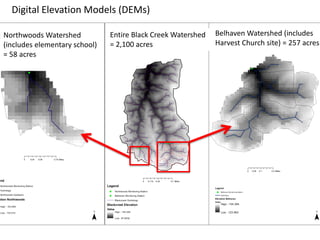
We performed watershed hydrology modeling using HEC-HMS (pronounced “HECK H M S”) for small subwatersheds in the headwater areas of the larger Black Creek watershed. These drainage areas included the proposed sites of Low Impact Development practices – Northwoods Elementary (left) and Harvest Church (right). Digital elevation models (DEMs) that were generated in ArcGIS ArcHydro are shown for each. This was the first step toward flow routing determination and accumulation for runoff predictions under varying impervious cover scenarios.
Land cover data from the National Land Cover Database (NLCD) was incorporated into GIS for each subwatershed. Here you see the reclassified versions of the land cover data where similar land covers were lumped into four groups. Reclassifications are shown in the table (may be difficult to see, sorry!)
The next step toward predicting runoff was to bring the soils data into the GIS. We used data from USDA NRCS Web Soil Survey for the two subwatersheds of interest. Knowing soil types allowed us to identify their respective Hydrologic Soil Group, which provided drainage class information (e.g. well-drained vs. poorly drained). This soil information, along with land cover data, allowed us to develop curve numbers (or runoff coefficients) for each watershed to use in the HEC-HMS model.
This slide shows HEC-HMS (pronounced “HECK H M S”) runoff modeling results for the Northwoods Elementary School Watershed (xx acres). Each graph shows rainfall amounts ranging from 0.1 to 1.0 inches (x-axis) with predicted runoff volumes on the y-axis (also in inches, which is volume of runoff divided by the watershed area). Scenarios for different impervious cover area percentages (5, 10, 25, and 50%) are given. You will notice the increase in runoff as impervious areas increase. For comparison, look at 1.0 inch of rainfall for all four scenarios (5 to 50% IC) as runoff increases from approx. 0.15 in. to 0.2 in. to 0.33 in. to 0.55 in. You can also think about this in terms of percentage of rainfall as runoff (e.g. for the 25% scenario, 0.33% of 1.0 in. of rainfall is discharged from the watershed). We are still working on Belhaven – it’s a little more complex of a watershed! We also had issues with the monitoring data for each but are working to resolve these and we will calibrate and validate these results before the project ends in a few months…