1. Easy access to mapped data in the EU
The plan4business team presents a public platform for harmonisation,
integration, storing and analysing of spatial and non-spatial data. After
one and half years of an intensive development and interaction with
stakeholders, the platform offers a series of spatial applications and
tools for data harmonisation and publication.
http://www.whatstheplan.eu/
The platform contains a large data pool of planning data including pan-European datasets
Urban Atlas, Corine Land Cover and Natura 2000; statistical information of EUROSTAT and
selected countries, national datasets such as cadastral information and flood zones; and regional
and local urban planning data. The platform is open for everyone and encourages users to share
their data and expand the data coverage on horizontal and vertical levels.
What are the benefits for me as a user? Besides data harmonisation and integration, the platform
enables various analyses based on the integrated datasets. The more spatial information is
available, the better and more precise analysis results can be retrieved.
The platform targets at different user groups. On the one side, there are tools for spatial data
experts. The Integration Engine enables harmonisation of your urban plans into the INSPIRE
Land Use schema and publish them in an interoperable way using the OGC web services. With
the Map Creator you can prepare a map of your choice by making an overlay of data from the
database as well of remote data connected using the OGC web services.
On the other side, the platform contains a set of spatial apps which are easy to use and show
the capabilities of the platform.
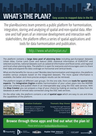
Location Evaluator
Thematic Map Viewer
Generate a comprehensive
report about a region, a
municipality or a point of
interest
Navigate through thematic
maps and predefined
analyses from local to
European level
Browse through these apps and find out what the plan is!
Please send us your feedback@plan4business.eu.