2. Watercolour by Francesc Soler i Rovira dated 1855 depicting the demolition of
the towers and walls along the Canaletes sector, in what is now Carrer de
Pelai.
On 7 August 1854, after more than a year of negotiations with the government in Madrid, the work on
demolishing the walls began, in the context of a new progresista [liberal] revolutionary period, in the middle
of financial and public health crises, with a new outbreak of cholera.
The elimination of the Ciutadella, nevertheless, was not to come about until 1868.
3. The progressive Espartero-O'Donnell government authorised the demolition of the walls in
1854. Nevertheless, the sea wall, Montjuïc Castle and the Citadel were excluded from that
authorisation. Picture of the land, in the Santa Madrona Portal area, around 1870; photographer
unknown.
4.
5. Remains of the medieval wall on Avinguda del Paral·lel, as photographed in
1913.
6.
7. A bird's-eye view of Barcelona with its walls from the sea. An urban landscape dominated by numerous chimneys and columns of smoke in the
Raval and the Sant Pere neighbourhood. To the right of the picture, the military citadel and the fields of Sant Martí de Provençals.
8. The Garriga I Roca 'quarterons'
The municipal architect Miquel Garriga i Roca drew up the celebrated quarterons, topographic maps which show in great detail the
state of buildings in historic Barcelona - now the Ciutat Vella district - in 1858. The picture numbers and shows the boundaries of
the quarterons
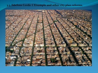
9.
10. The first of Garriga i Roca's quarterons
The first of Garriga i Roca's attempts to
show the built-up reality of historical
Barcelona, from 1858, relates to the Pla de
Palau, with the old Palau Reial (no longer
extant) and Santa Maria del Mar, among
other buildings.
11.
12.
13. The picture shows an area of the city that has radically altered over the years: to the left, the Llotja building, and to the
right, the old Sant Sebastià convent, pulled down after the opening up of Via Laietana, as was a good part of Carrer del
Consolat, with its characteristic arcades, now all but gone.
14.
15.
16. A ground-plan view of the City Hall in 1858, with the Sant Miquel church still attached to the building, in the space now
occupied by the square bearing its name. To the left of the picture, the old Ensenyança convent, whose sole surviving trace
lies in the area's name.
17.
18. Ground-plan view of the Palau de la Generalitat in 1858. During this period the building housed the Barcelona regional
court and Provincial Council. To the left of the picture, the Call, or Jewish quarter.
19.
20. The Plaça del Rei, as seen by Garriga i Roca
In 1858 the Plaça del Rei looked very
different from how it appears today.
The old Palau Reial Major's outbuildings
housed the Santa Clara convent, while the
Saló del Tinell was completely disfigured.
The square contained a neo-Gothic fountain
and a column from the ancient Roman
temple of Augustus, later moved to its
original site where it is still kept.
21. With the medieval walls gone, it was
possible to start the preliminary work
required for the actual expansion of the city
to get underway.
Topographic maps were drawn up of the
plain, by Ildefons Cerdà (1855), and of the
historic centre of the city (present-day
Ciutat Vella), neighbourhood by
neighbourhood, quarter by quarter, by
Miquel Garriga i Roca, which was popularly
known as quarterons.
Panoramic view of Barcelona and Tibidabo mountain as seen from Montjuïc
mountain at the end of the 19th century.
22. With the elimination of the walls, Barcelona was in a
position to deal seriously with the question of urban
growth. The development of the Barcelona plain was the
prerogative of the Ministry of Public Works, which is
why the project had to be approved in Madrid.
The key figure at the time was the civil engineer Ildefons
Cerdà i Sunyol, author of the 1859 Pla d'Eixample
[Expansion Plan] and a modern theory (1867) on urban
planning, the Teoría general de la urbanización y
aplicación de sus principios y doctrinas a la reforma
y ensanche de Barcelona [General theory of urban
development and the application of its principles and
doctrines to the reform and expansion of Barcelona].
Ildefons Cerdà
(Centelles, 1815-Caldas de Besaya, Santander, 1876).
Educated in civil engineering at the School of Road and
Port Engineers in Madrid (1836-1841).
Affiliated to the Progresista party.
Cerdà devoted himself entirely to politics from 1849.
In Barcelona he held various public offices, such as
member of the Spanish Parliament (1850), as well as
others on the City Council.
23. In 1855 Cerdà presented an accurate topographic plan of the Barcelona plain, before he drew up his
famous expansion plan for the city.
24. With its walls finally demolished, Barcelona was ready to expand across the plain. But this had to be
done in an orderly way: the Madrid government gave its approval to the Ildefons Cerdà plan, which went
down badly in Barcelona. Ildefons Cerdà's expansion plan for Barcelona, approved by Madrid in 1859.
25. But there were other plans before Cerdà…
In 1858 the City Council invited tenders. Many architects did acompetition for the expansion project.
Garriga I Roca presented an expansion plan for the city that envisaged union only with the town of
Gràcia.
He drew up, among other things, the alignment plan for Ciutat Vella and a detailed map of the historic
centre known as quarterons.
Garriga i Roca's
expansion
plan 1858
26. but the winner was: Antoni Rovira i
Trias
Antoni Rovira i Trias was the winner of the competition
orginised by the City Council.
Hailing from a family of architects, besides winning the
competition for designing Barcelona's expansion with a
plan that would ultimately never be implemented,
Rovira i Trias left his mark on the city with such work as
the Barceloneta, Sants and Concepció markets and the
seats of the old town halls of Sant Martí de Provençals
and Les Corts.
Antoni Rovira i Trias monument in the square named
after him in the Gràcia district.

![Watercolour by Francesc Soler i Rovira dated 1855 depicting the demolition of
the towers and walls along the Canaletes sector, in what is now Carrer de
Pelai.
On 7 August 1854, after more than a year of negotiations with the government in Madrid, the work on
demolishing the walls began, in the context of a new progresista [liberal] revolutionary period, in the middle
of financial and public health crises, with a new outbreak of cholera.
The elimination of the Ciutadella, nevertheless, was not to come about until 1868.](data:image/gif;base64,R0lGODlhAQABAIAAAAAAAP///yH5BAEAAAAALAAAAAABAAEAAAIBRAA7)