Utility Mapping: Way to Find Underground Utility Lines
•
0 likes•218 views

Cat Surveys use various techniques and equipment such as Electromagnetic Locators (EML) and Ground Penetrating Radar (GPR) to accurately identify underground features and utility apparatus in Essex. Contact us on 01277 226 600.

Recommended
Recommended
More Related Content
Recently uploaded
Recently uploaded (20)
Featured
Featured (20)
Utility Mapping: Way to Find Underground Utility Lines
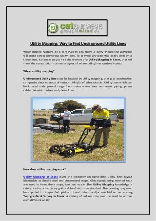
- 1. Utility Mapping: Way to Find Underground Utility Lines When digging happens on a construction site, there is every chance the worker(s) will come across numerous utility lines. To prevent any potential costly destroy to these lines, it is necessary to hire the services of a Utility Mapping in Essex, that will show the construction business a layout of where utility lines can be situated. What's utility mapping? Underground Utility Lines can be located by utility mapping, that give construction companies detailed maps of various utility lines' whereabouts. Utility lines which can be located underground range from mains water lines and sewer piping, power cables, television wires and phone lines. How does utility mapping work? Utility Mapping in Essex gives the customer an up-to-date utility lines layout obtainable as dimensional and dimensional maps. Global positioning method tools are used to form these maps, fast and easily. The Utility Mapping knowledge is referenced to an arbitrary grid and level datum as standard. The drawing may even be supplied to a specified grid and level datum and/or overlaid on an existing Topographical Survey in Essex. A variety of colours may even be used to outline each different utility.
- 2. Utility Mapping Technologies A range of technologies are employed by these companies in order to locate different utility lines. Utility Mapping Technologies in Essex include electromagnetic detection, acoustic detection, ground penetrating radars and live-line detectors. Different techniques must be adopted to spot different types of matter like metal, plastic, concrete, ceramic or fibre optic parts. Additional Utility Mapping Details The customer can also request additional details from their Utility Mapping Company in Essex. These additional details include fixed surface utility features including inspection chambers or telegraph poles, along with key topographic features such as fence lines as well as kerb lines. Street names, building names and house numbers may even be included in the client's map to help in the site location. About Company: Cat Surveys use various techniques and equipment such as Electromagnetic Locators (EML) and Ground Penetrating Radar (GPR) to accurately identify underground features and utility apparatus in Essex. For More Details Please Visit: http://www.cat-surveys.com/