SlideShare a Scribd company logo
1 of 1
Download to read offline
Communicating and Transforming Earth Observation Data to
 Actionable Information for Volcanic Ash Warning Systems
                  B. L. Bye (bye@lilja.no), A. Durant (adu@nilu.no) & F. Prata (fpr@nilu.no)
                                                                                                              BLB, NILU


                          Introduction                                                                            Earth Observations to Operations


                                                                                                                                                    Eyjafjallajökull 2010
Earth observations represent an important element in
improving knowledge of hazards, risks and potential
disasters. This knowledge serves as basis for efficient
decision making, better mitigation and prepardness. It is
necessary and possible to facilitate more efficient
integration of Earth observations and scientific results in an
operative ash warning system. Results from ESA's SAVAA
project and GEO's general efforts to make data more
                                                                                                                                           ESA                                                                                                                    Kristin Vogsfjord
accessible and interoperable are used as examples.


       Ash warning system


                                                                                                                                                                                                                                      Science and Earth Observations
The World Meteorological Organization (WMO), the
International Civil Aviation Organization (ICAO) and
the International Union of Geodesy and Geophysics
(IUGG) jointly established the International Airways
Volcano Watch. It consists of 9 Volcanic Ash Advisory
Centers (VAACs) providing global coverage of ash
warnings through Volcanic Ash Significant Meteorological
Information (VA SIGMET) that is issued from
Meteorological Watch Offices (MWO) to National Civil
Aviation Authorities. This information is sent to national air
traffic controllers and finally reaches the end users – the
pilots and dispatchers who are responsible for
passenger safety.


                                                                                                           ESA's SAVAA project has demonstrated
                                                                                                           that information about the distribution,
                                                                                                           composition and amount of volcanic ash
                                                                                                           can be provided in a timely manner to
                                                                                                           VAACs. This information can be
                                                                                                           transmitted in-flight and will come in
                                                                                                           addition to the pre-flight VA SIGMETs.                           The world is divided
                                                                                                                                                                            into 9 VAACs.


                                                                                                                                                                                                          Actionable
Volcanic Notice to Aviation (VONA), for the VAACs was                                                                                                                                                    information
established to integrate scientific data and information into the
warning system. The final information products reaching the end
users are so-called VA SIGMETs. (Volcanic Ash Significant
Meteorological Information).


Group on Earth Observations
The Group on Earth Observations is coordinating efforts to
build a Global Earth Observation System of Systems
(GEOSS) that will provide decision-support for a wide
variety of users.
A community of practice is a
user-led community of
stakeholders, from providers to
the final beneficiaries of EO
data and information, with a                                                                                     Community of Practice
common interest in specific
aspects of societal benefits to
be realized by GEOSS.
                                                                                                                                                                                                                                                                  Kathrine Roede
GEO's Geohazards Community of Practice can be used to
                                                                                                                                                                                  Pilots go trough regulated and established
retrieve and analyse user requirements for ash warning                                                                                                                            routines, and receive reliable information
systems.

                         Bibliography
                                                                                                                       Conclusion                                                 such as VA SIGMETs before they make
                                                                                                                                                                                  their final decisions.

 B. L. Bye, Multitasking in Academia. Effective combinations of research, education and public
 outreach illustrated by a volcanic ash warning system, American Geophysical Union 2011
                                                                                                           The current ash warning systems can be made faster and more homogeneous. It is easy to
 Prata, A. J., 2008, Satellite detection of hazardous volcanic clouds and the risk to global air traffic,   collect, process and transfer satellite, air-borne and in-situ data products to any VAAC. A
 Natural Hazards, DOI 10.1007/s11069-008-9273-z
                                                                                                           warning service can be set up to serve pilots by direct communication with the cockpit.
                                                                                                           Training and institutional adaptation is necessary in order to fully exploit state-of-the-art
                                                                                                           science and technology.

                                                                                                           Acknowledgment. ESA provided funding for the Support to Aviation for Volcanic Ash Avoidance (SAVAA) project.
                                                                                                                                                                                                              www.postersession.com

More Related Content

Similar to Volcanic Ash Warning System: Communicating and Transforming Earth Observation Data to Actionable Information

110510 aq co_p_network
110510 aq co_p_network110510 aq co_p_network
110510 aq co_p_networkRudolf Husar
 
Space Weather And International Civil Space Situational Awareness ( Met...
Space  Weather And  International  Civil  Space  Situational  Awareness ( Met...Space  Weather And  International  Civil  Space  Situational  Awareness ( Met...
Space Weather And International Civil Space Situational Awareness ( Met...Western Governors University
 
LANDSLIDE EARLY WARNING SYSTEM
LANDSLIDE EARLY WARNING SYSTEMLANDSLIDE EARLY WARNING SYSTEM
LANDSLIDE EARLY WARNING SYSTEMvivatechijri
 
Priliminary design and prototype scale model of offshore acqaculture flating ...
Priliminary design and prototype scale model of offshore acqaculture flating ...Priliminary design and prototype scale model of offshore acqaculture flating ...
Priliminary design and prototype scale model of offshore acqaculture flating ...Oladokun Sulaiman Olanrewaju
 
IRJET- Tool: Segregration of Bands in Sentinel Data and Calculation of NDVI
IRJET-  	  Tool: Segregration of Bands in Sentinel Data and Calculation of NDVIIRJET-  	  Tool: Segregration of Bands in Sentinel Data and Calculation of NDVI
IRJET- Tool: Segregration of Bands in Sentinel Data and Calculation of NDVIIRJET Journal
 
Use of EOSC to support Protected Area Management applications in the context ...
Use of EOSC to support Protected Area Management applications in the context ...Use of EOSC to support Protected Area Management applications in the context ...
Use of EOSC to support Protected Area Management applications in the context ...EOSC-hub project
 
Modelling of life safety in water resource decision making
Modelling of life safety in water resource decision makingModelling of life safety in water resource decision making
Modelling of life safety in water resource decision makinghamedassaf
 
Rehabilitation and Sustainable Managment of Peatlands in South East Asia
Rehabilitation and Sustainable Managment of Peatlands in South East AsiaRehabilitation and Sustainable Managment of Peatlands in South East Asia
Rehabilitation and Sustainable Managment of Peatlands in South East AsiaWetlands International
 
111018 geo sif_aq_interop
111018 geo sif_aq_interop111018 geo sif_aq_interop
111018 geo sif_aq_interopRudolf Husar
 
GEO activities on Disaster Risk Reduction and GEO Web Portal
GEO activities on Disaster Risk Reduction and GEO Web PortalGEO activities on Disaster Risk Reduction and GEO Web Portal
GEO activities on Disaster Risk Reduction and GEO Web PortalUN-SPIDER
 
MTI_Nov2010
MTI_Nov2010MTI_Nov2010
MTI_Nov2010basswx
 
60 Years of Successful Scientific Collaboration on Weather, Climate and Water...
60 Years of Successful Scientific Collaboration on Weather, Climate and Water...60 Years of Successful Scientific Collaboration on Weather, Climate and Water...
60 Years of Successful Scientific Collaboration on Weather, Climate and Water...Tim Goos
 
Deep Learning for Denoising Bioluminescent Interference and Electronic Artifa...
Deep Learning for Denoising Bioluminescent Interference and Electronic Artifa...Deep Learning for Denoising Bioluminescent Interference and Electronic Artifa...
Deep Learning for Denoising Bioluminescent Interference and Electronic Artifa...IRJET Journal
 
DISASTER PREDICTION
DISASTER PREDICTIONDISASTER PREDICTION
DISASTER PREDICTIONLibcorpio
 
110509 aq co_p_solta
110509 aq co_p_solta110509 aq co_p_solta
110509 aq co_p_soltaRudolf Husar
 
Mapping the Tohoku 2011 Tsunami event with a remote sensing satellite constel...
Mapping the Tohoku 2011 Tsunami event with a remote sensing satellite constel...Mapping the Tohoku 2011 Tsunami event with a remote sensing satellite constel...
Mapping the Tohoku 2011 Tsunami event with a remote sensing satellite constel...Peter Löwe
 

Similar to Volcanic Ash Warning System: Communicating and Transforming Earth Observation Data to Actionable Information (20)

110510 aq co_p_network
110510 aq co_p_network110510 aq co_p_network
110510 aq co_p_network
 
Space Weather And International Civil Space Situational Awareness ( Met...
Space  Weather And  International  Civil  Space  Situational  Awareness ( Met...Space  Weather And  International  Civil  Space  Situational  Awareness ( Met...
Space Weather And International Civil Space Situational Awareness ( Met...
 
LANDSLIDE EARLY WARNING SYSTEM
LANDSLIDE EARLY WARNING SYSTEMLANDSLIDE EARLY WARNING SYSTEM
LANDSLIDE EARLY WARNING SYSTEM
 
Mercator Ocean newsletter 31
Mercator Ocean newsletter 31Mercator Ocean newsletter 31
Mercator Ocean newsletter 31
 
Priliminary design and prototype scale model of offshore acqaculture flating ...
Priliminary design and prototype scale model of offshore acqaculture flating ...Priliminary design and prototype scale model of offshore acqaculture flating ...
Priliminary design and prototype scale model of offshore acqaculture flating ...
 
IRJET- Tool: Segregration of Bands in Sentinel Data and Calculation of NDVI
IRJET-  	  Tool: Segregration of Bands in Sentinel Data and Calculation of NDVIIRJET-  	  Tool: Segregration of Bands in Sentinel Data and Calculation of NDVI
IRJET- Tool: Segregration of Bands in Sentinel Data and Calculation of NDVI
 
Use of EOSC to support Protected Area Management applications in the context ...
Use of EOSC to support Protected Area Management applications in the context ...Use of EOSC to support Protected Area Management applications in the context ...
Use of EOSC to support Protected Area Management applications in the context ...
 
NewAge
NewAgeNewAge
NewAge
 
Modelling of life safety in water resource decision making
Modelling of life safety in water resource decision makingModelling of life safety in water resource decision making
Modelling of life safety in water resource decision making
 
Rehabilitation and Sustainable Managment of Peatlands in South East Asia
Rehabilitation and Sustainable Managment of Peatlands in South East AsiaRehabilitation and Sustainable Managment of Peatlands in South East Asia
Rehabilitation and Sustainable Managment of Peatlands in South East Asia
 
AAS National Conference 2008: Gary Davis
AAS National Conference 2008: Gary DavisAAS National Conference 2008: Gary Davis
AAS National Conference 2008: Gary Davis
 
111018 geo sif_aq_interop
111018 geo sif_aq_interop111018 geo sif_aq_interop
111018 geo sif_aq_interop
 
GEO activities on Disaster Risk Reduction and GEO Web Portal
GEO activities on Disaster Risk Reduction and GEO Web PortalGEO activities on Disaster Risk Reduction and GEO Web Portal
GEO activities on Disaster Risk Reduction and GEO Web Portal
 
CAMS GS Global Analyses
CAMS GS Global Analyses  CAMS GS Global Analyses
CAMS GS Global Analyses
 
MTI_Nov2010
MTI_Nov2010MTI_Nov2010
MTI_Nov2010
 
60 Years of Successful Scientific Collaboration on Weather, Climate and Water...
60 Years of Successful Scientific Collaboration on Weather, Climate and Water...60 Years of Successful Scientific Collaboration on Weather, Climate and Water...
60 Years of Successful Scientific Collaboration on Weather, Climate and Water...
 
Deep Learning for Denoising Bioluminescent Interference and Electronic Artifa...
Deep Learning for Denoising Bioluminescent Interference and Electronic Artifa...Deep Learning for Denoising Bioluminescent Interference and Electronic Artifa...
Deep Learning for Denoising Bioluminescent Interference and Electronic Artifa...
 
DISASTER PREDICTION
DISASTER PREDICTIONDISASTER PREDICTION
DISASTER PREDICTION
 
110509 aq co_p_solta
110509 aq co_p_solta110509 aq co_p_solta
110509 aq co_p_solta
 
Mapping the Tohoku 2011 Tsunami event with a remote sensing satellite constel...
Mapping the Tohoku 2011 Tsunami event with a remote sensing satellite constel...Mapping the Tohoku 2011 Tsunami event with a remote sensing satellite constel...
Mapping the Tohoku 2011 Tsunami event with a remote sensing satellite constel...
 

Volcanic Ash Warning System: Communicating and Transforming Earth Observation Data to Actionable Information

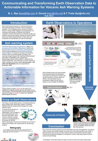
  • 1. Communicating and Transforming Earth Observation Data to Actionable Information for Volcanic Ash Warning Systems B. L. Bye (bye@lilja.no), A. Durant (adu@nilu.no) & F. Prata (fpr@nilu.no) BLB, NILU Introduction Earth Observations to Operations Eyjafjallajökull 2010 Earth observations represent an important element in improving knowledge of hazards, risks and potential disasters. This knowledge serves as basis for efficient decision making, better mitigation and prepardness. It is necessary and possible to facilitate more efficient integration of Earth observations and scientific results in an operative ash warning system. Results from ESA's SAVAA project and GEO's general efforts to make data more ESA Kristin Vogsfjord accessible and interoperable are used as examples. Ash warning system Science and Earth Observations The World Meteorological Organization (WMO), the International Civil Aviation Organization (ICAO) and the International Union of Geodesy and Geophysics (IUGG) jointly established the International Airways Volcano Watch. It consists of 9 Volcanic Ash Advisory Centers (VAACs) providing global coverage of ash warnings through Volcanic Ash Significant Meteorological Information (VA SIGMET) that is issued from Meteorological Watch Offices (MWO) to National Civil Aviation Authorities. This information is sent to national air traffic controllers and finally reaches the end users – the pilots and dispatchers who are responsible for passenger safety. ESA's SAVAA project has demonstrated that information about the distribution, composition and amount of volcanic ash can be provided in a timely manner to VAACs. This information can be transmitted in-flight and will come in addition to the pre-flight VA SIGMETs. The world is divided into 9 VAACs. Actionable Volcanic Notice to Aviation (VONA), for the VAACs was information established to integrate scientific data and information into the warning system. The final information products reaching the end users are so-called VA SIGMETs. (Volcanic Ash Significant Meteorological Information). Group on Earth Observations The Group on Earth Observations is coordinating efforts to build a Global Earth Observation System of Systems (GEOSS) that will provide decision-support for a wide variety of users. A community of practice is a user-led community of stakeholders, from providers to the final beneficiaries of EO data and information, with a Community of Practice common interest in specific aspects of societal benefits to be realized by GEOSS. Kathrine Roede GEO's Geohazards Community of Practice can be used to Pilots go trough regulated and established retrieve and analyse user requirements for ash warning routines, and receive reliable information systems. Bibliography Conclusion such as VA SIGMETs before they make their final decisions. B. L. Bye, Multitasking in Academia. Effective combinations of research, education and public outreach illustrated by a volcanic ash warning system, American Geophysical Union 2011 The current ash warning systems can be made faster and more homogeneous. It is easy to Prata, A. J., 2008, Satellite detection of hazardous volcanic clouds and the risk to global air traffic, collect, process and transfer satellite, air-borne and in-situ data products to any VAAC. A Natural Hazards, DOI 10.1007/s11069-008-9273-z warning service can be set up to serve pilots by direct communication with the cockpit. Training and institutional adaptation is necessary in order to fully exploit state-of-the-art science and technology. Acknowledgment. ESA provided funding for the Support to Aviation for Volcanic Ash Avoidance (SAVAA) project. www.postersession.com