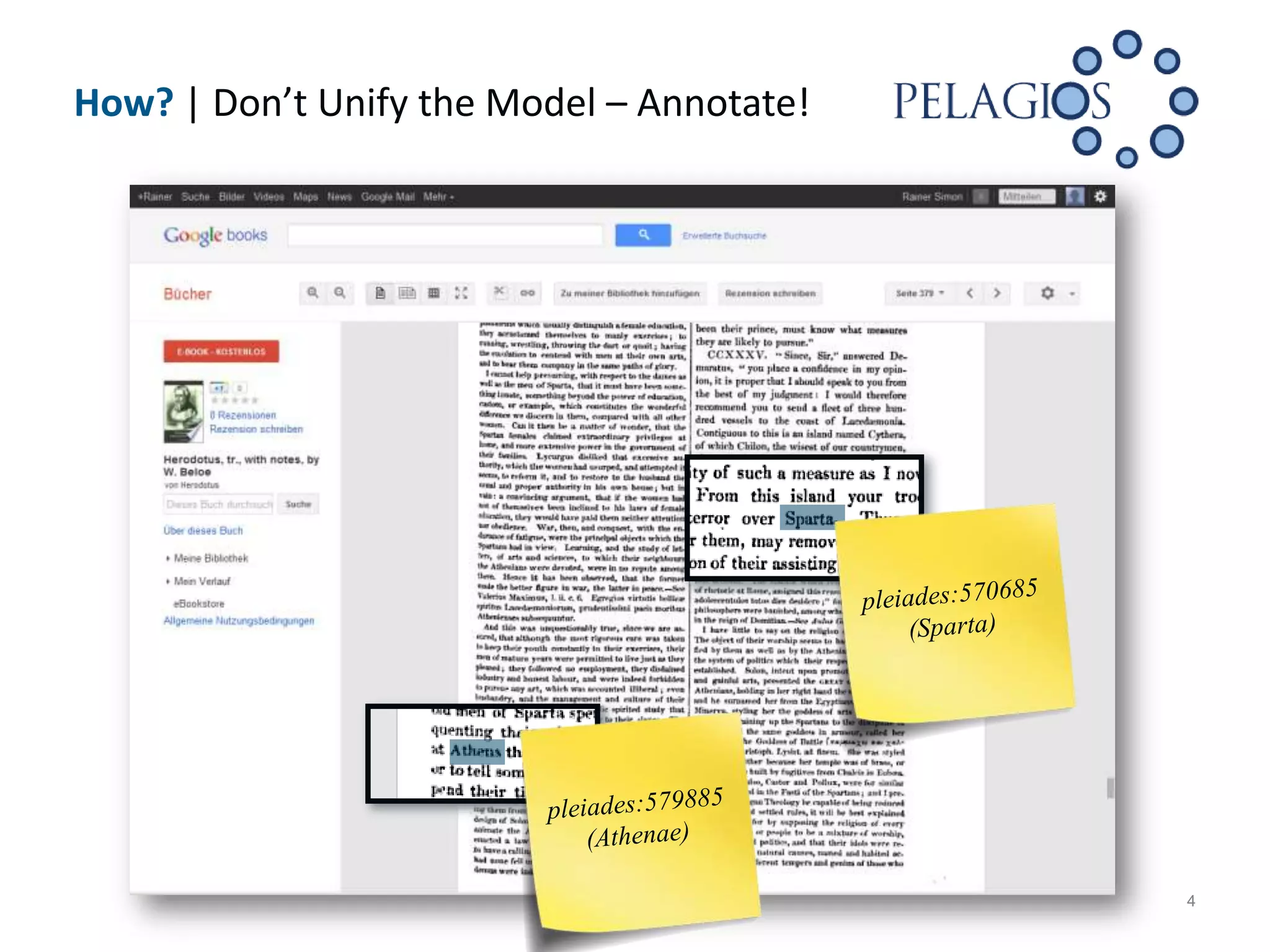
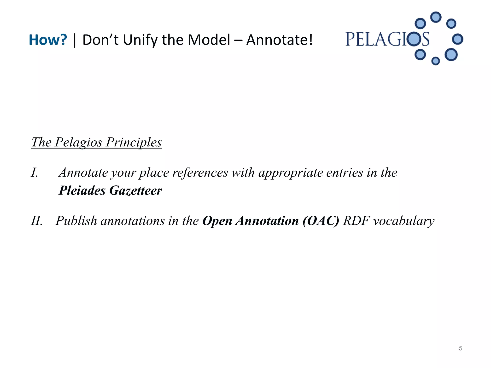
PELAGIOS
Interlinking Ancient World Research Resources
Through Place
Elton Barker
The Open University
Leif Isaksen
University of Southampton
Rainer Simon
Austrian Institute of Technology


February 2, 2012 | Berlin, Germany
What? | Aims of Pelagios


 Interlinking data about the Ancient World using Linked Open Data (LOD)
  methods

 Focus on place references (in maps, texts,
  images, database tables)

 Establishing simple “Pelagios Principles” to
  support contributors in preparing
  their data


                                                                           2
Who? | The Pelagios Collective


   The Open University                   Open Context
   University of Southampton             Perseus Digital Library
   Austrian Institute of Technology      Ptolemy Machine
   Pleiades                              SPQR
   Arachne                               Ure Museum
   Claros
   Fasti Online
   Google Ancient Places
   nomisma.org


                                                                     3
How? | Don’t Unify the Model – Annotate!


                                           4
How? | Don’t Unify the Model – Annotate!


The Pelagios Principles

I.   Annotate your place references with appropriate entries in the
     Pleiades Gazetteer

II. Publish annotations in the Open Annotation (OAC) RDF vocabulary


                                                                      5
Why? | Piecing the Puzzle Together


                                     6
Why? | Example: The Graph Explorer


  Exploring Relations between        Exploring Relations between
      Places through Data                Data through Place

                                                                   7
Challenges | Some Issues Identified So Far


 Issues with automatic matching (data or in-house Gazetter)
     Name-based matching based on Pleiades or Pleiades+ [1] toponyms
     Followed by coordinate matching for verification/disambiguation
 Granularity & vague references (South Italy, Greek Islands)
 Location-based adjectives (Corinthian vs. Corinth)
 Typing of place references
    Find spot vs. origin, “depicts”, etc.
    Uncertain references (probably made in…, from the vicinity of…)


[1] Pleiades+ toponym extension to Pleiades based on Geonames
    http://googleancientplaces.wordpress.com/pleiades/                  8
Discussion | Annotation vs. Unified Model


 The goal of Pelagios is to
    create links rather than to aggregate and enrich
    provide a toolkit & an API rather than a “single point of access”

 Pelagios requests that partners map
    data to a vocabulary rather than their metadata schema to another

 The fact that Pelagios is limited in scope helps!
    Restriction to Place
    Very limited set of “primitives” – Dataset, (typed?) Annotation, Place


                                                                              9
Thank you for your attention
http://pelagios-project.blogspot.com
Questions!


Cliparts by www.psdgraphics.com
                                       10

PELAGIOS Project Overview

  • 1.
    PELAGIOS Interlinking Ancient WorldResearch Resources Through Place Elton Barker The Open University Leif Isaksen University of Southampton Rainer Simon Austrian Institute of Technology February 2, 2012 | Berlin, Germany
  • 2.
    What? | Aimsof Pelagios  Interlinking data about the Ancient World using Linked Open Data (LOD) methods  Focus on place references (in maps, texts, images, database tables)  Establishing simple “Pelagios Principles” to support contributors in preparing their data 2
  • 3.
    Who? | ThePelagios Collective  The Open University  Open Context  University of Southampton  Perseus Digital Library  Austrian Institute of Technology  Ptolemy Machine  Pleiades  SPQR  Arachne  Ure Museum  Claros  Fasti Online  Google Ancient Places  nomisma.org 3
  • 4.
    How? | Don’tUnify the Model – Annotate! 4
  • 5.
    How? | Don’tUnify the Model – Annotate! The Pelagios Principles I. Annotate your place references with appropriate entries in the Pleiades Gazetteer II. Publish annotations in the Open Annotation (OAC) RDF vocabulary 5
  • 6.
    Why? | Piecingthe Puzzle Together 6
  • 7.
    Why? | Example:The Graph Explorer Exploring Relations between Exploring Relations between Places through Data Data through Place 7
  • 8.
    Challenges | SomeIssues Identified So Far  Issues with automatic matching (data or in-house Gazetter)  Name-based matching based on Pleiades or Pleiades+ [1] toponyms  Followed by coordinate matching for verification/disambiguation  Granularity & vague references (South Italy, Greek Islands)  Location-based adjectives (Corinthian vs. Corinth)  Typing of place references  Find spot vs. origin, “depicts”, etc.  Uncertain references (probably made in…, from the vicinity of…) [1] Pleiades+ toponym extension to Pleiades based on Geonames http://googleancientplaces.wordpress.com/pleiades/ 8
  • 9.
    Discussion | Annotationvs. Unified Model  The goal of Pelagios is to  create links rather than to aggregate and enrich  provide a toolkit & an API rather than a “single point of access”  Pelagios requests that partners map  data to a vocabulary rather than their metadata schema to another  The fact that Pelagios is limited in scope helps!  Restriction to Place  Very limited set of “primitives” – Dataset, (typed?) Annotation, Place 9
  • 10.
    Thank you foryour attention http://pelagios-project.blogspot.com Questions! Cliparts by www.psdgraphics.com 10