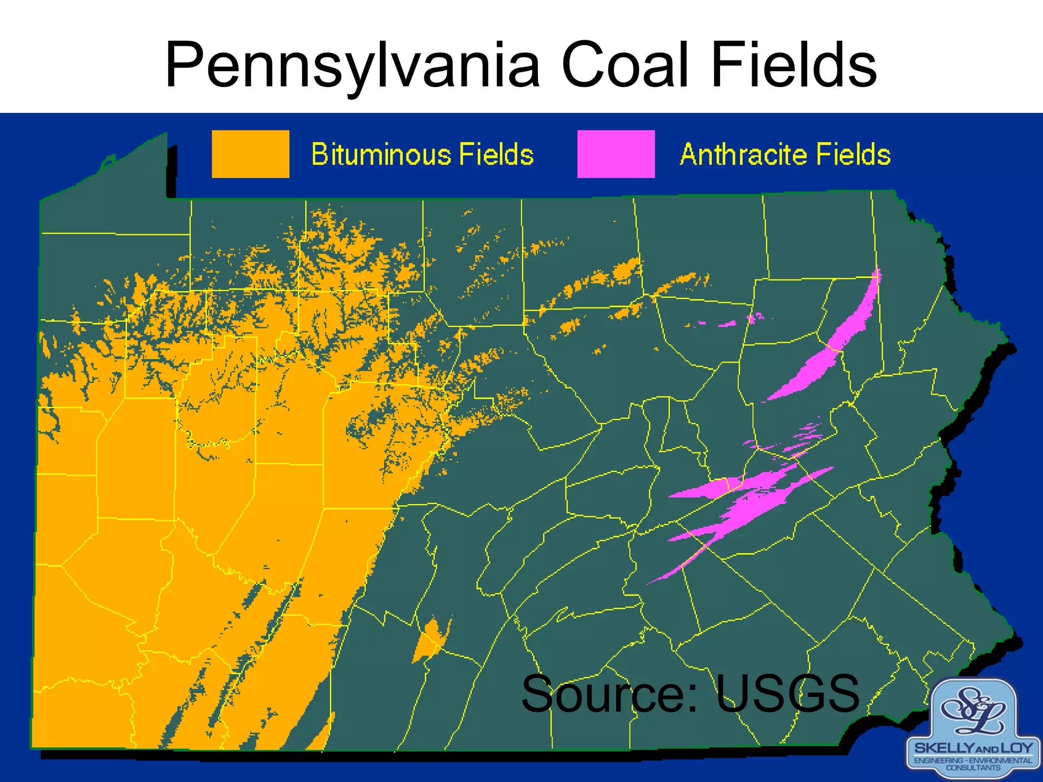
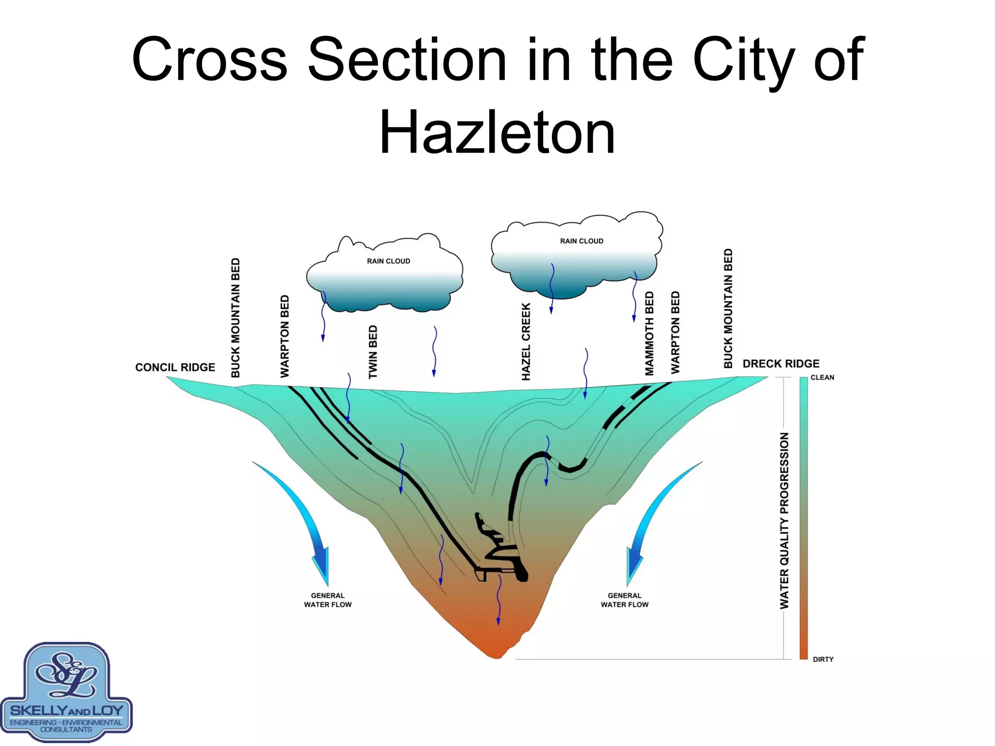
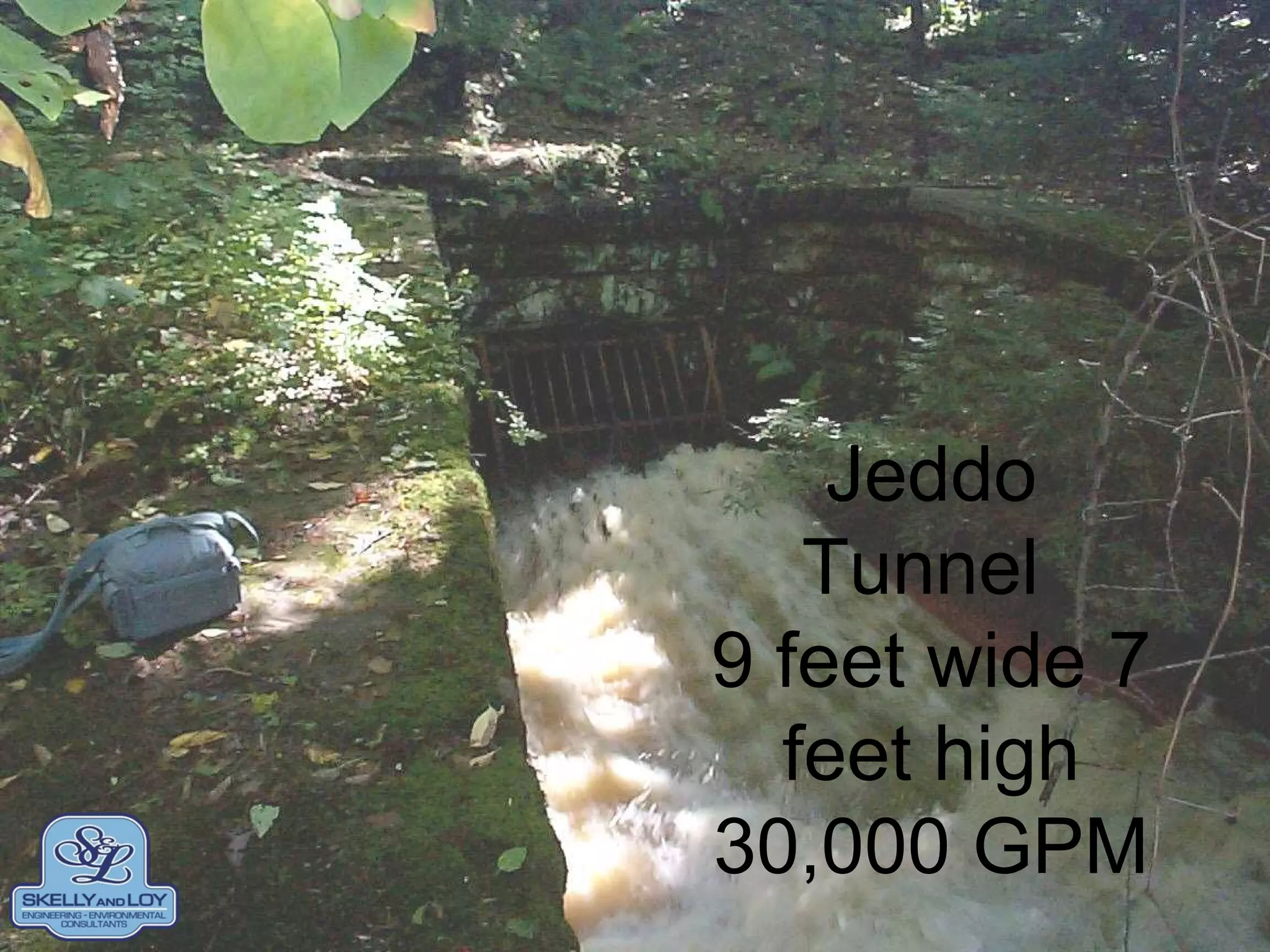
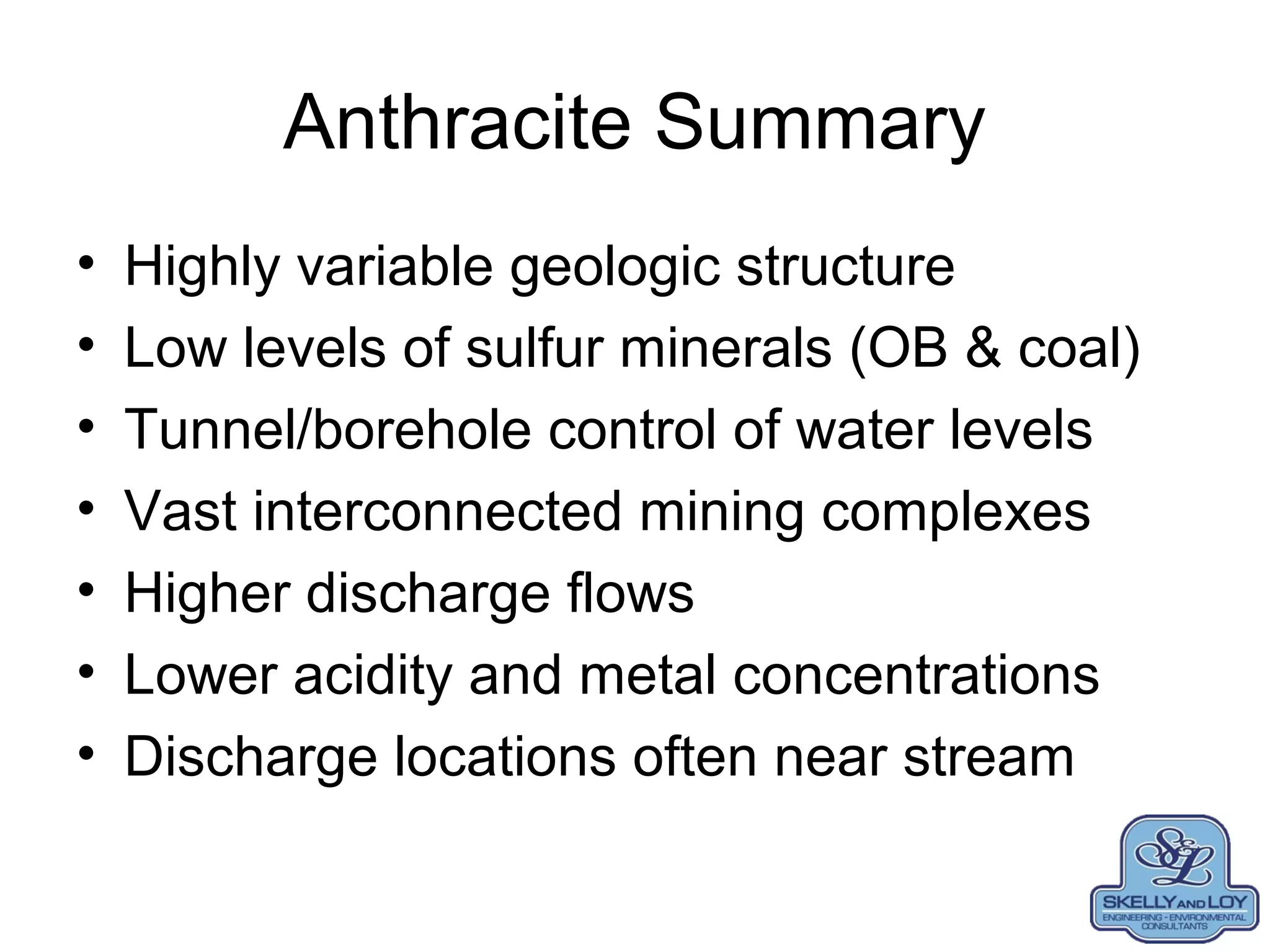
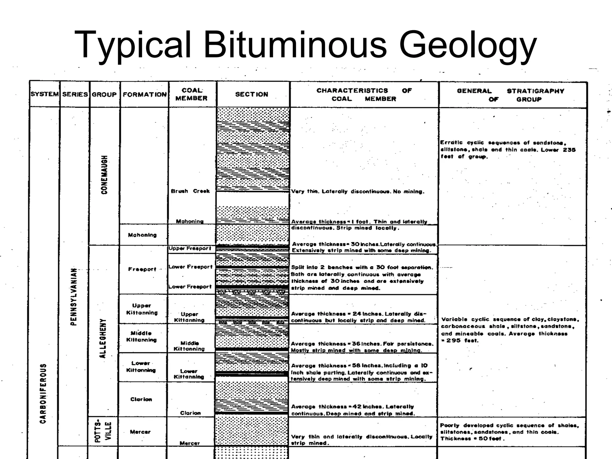
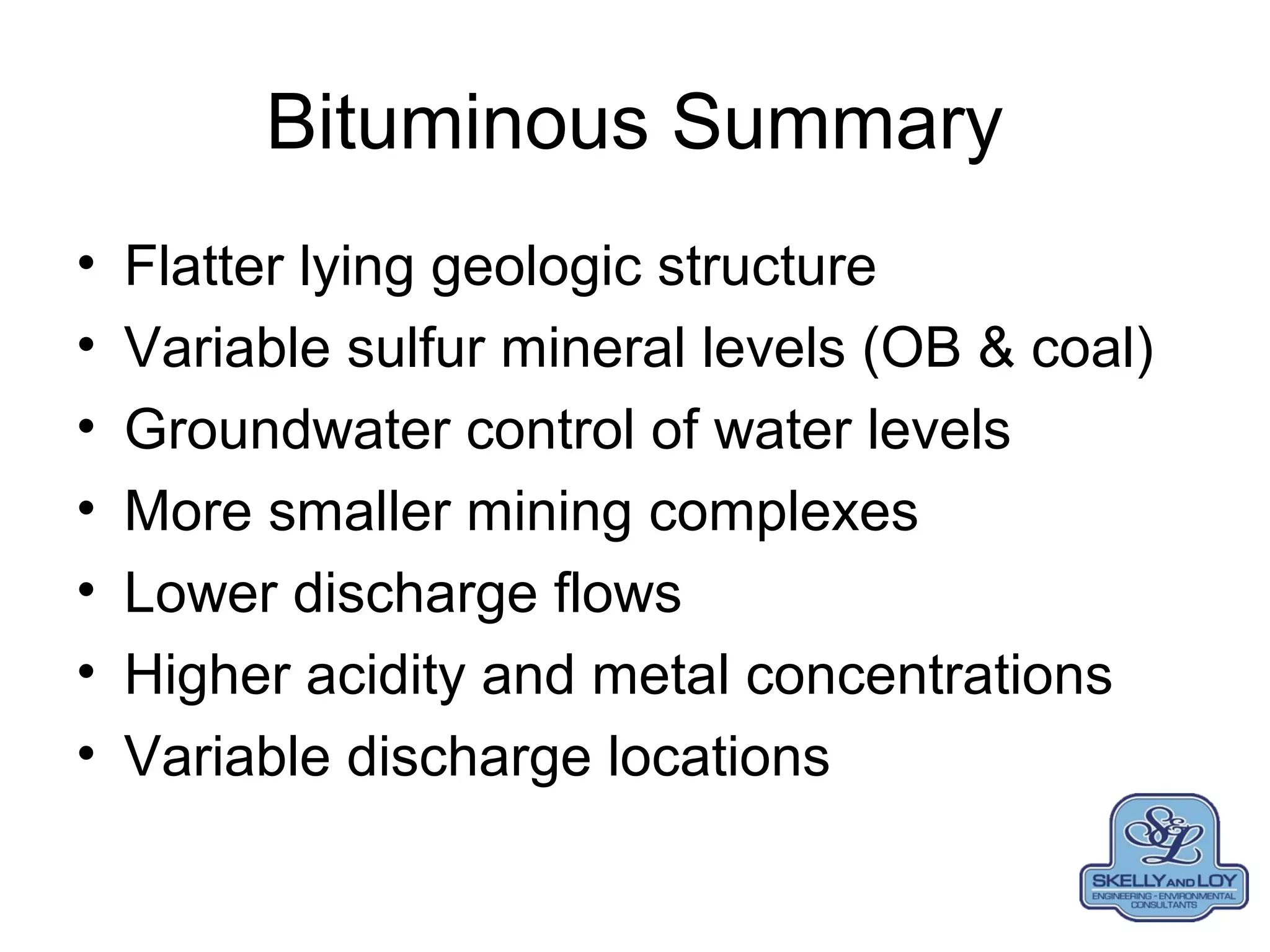
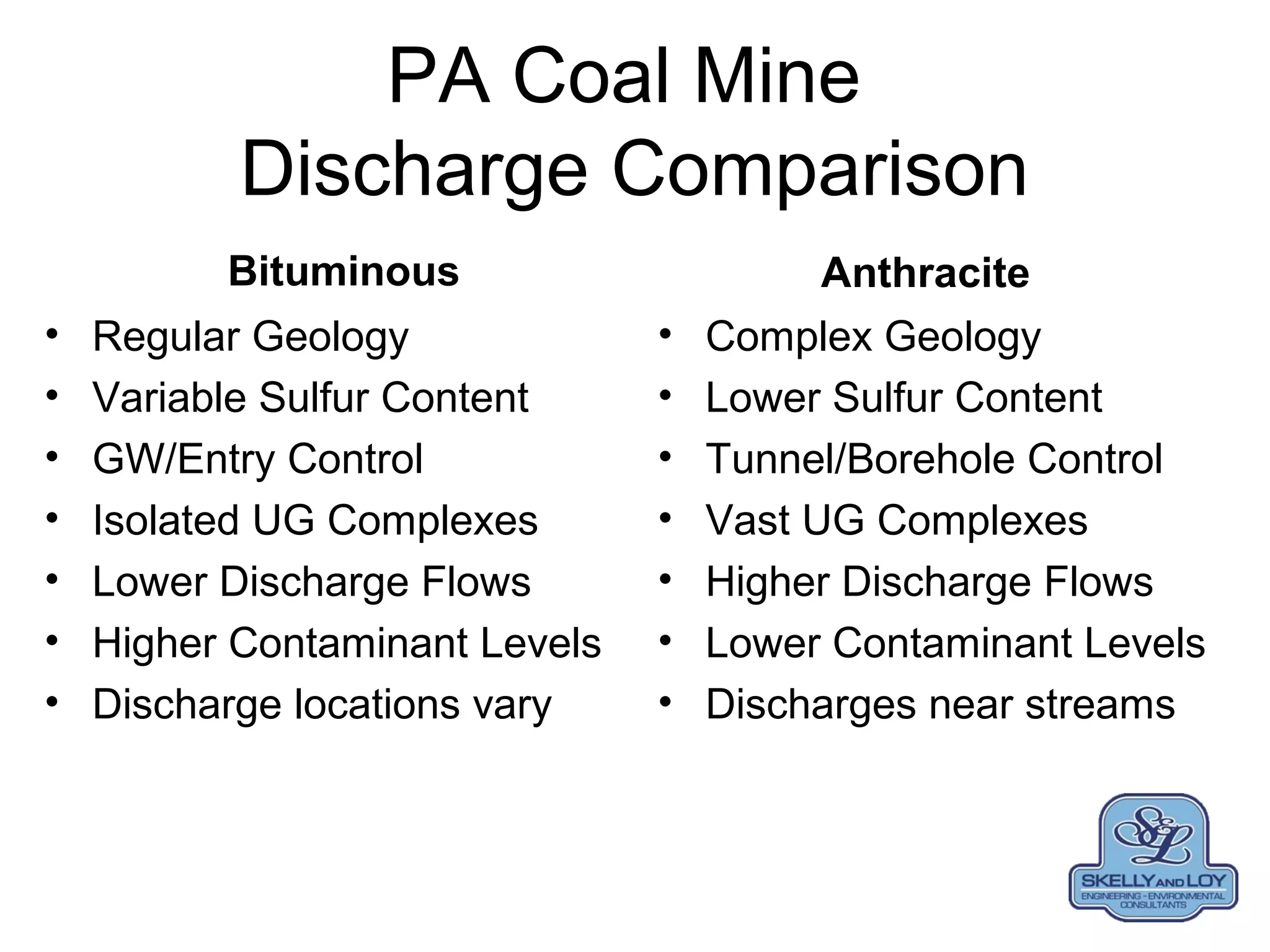
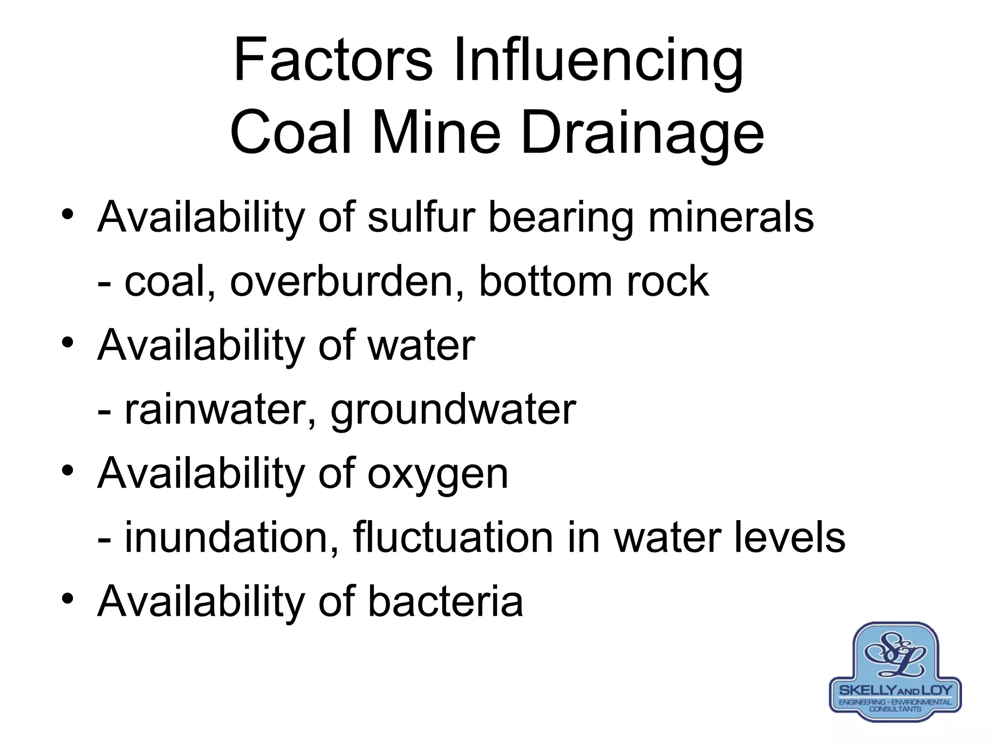
Variability of Coal Mine Drainage in
Pennsylvania Resulting from Coal
Mining Practices and Geology
Terry W. Schmidt
• Presented at Pennsylvania Abandoned Mine
Reclamation Conference, August 10, 2013.
• Terry W. Schmidt, P.E., Vice President,
Engineering, Skelly And Loy, Inc., 2601 North
Front Street, Harrisburg, PA 17110.
Presentation Promises
• No formulas
• Few technical terms
- (keep it simple)
• Lots of pictures
• Mostly generalizations
- (won’t dwell on exceptions)
AMD Formation
Pyrite (sulfur)
+
Oxygen
+
Water
+
Bacteria
=
AMD (Coal Mine Drainage)
Pennsylvania Coal Fields
Source: USGS
Anthracite Regional History
• Mid-1800’s
– coal was extensively mined
– fueled America’s industrial revolution
– coal became the economic base of the region
• Post-1917
– coke replaced anthracite in steel-making
– demand for anthracite coal declined
– coal-related employment declined
• 1950’s
– many remaining active mines were flooded
– major underground mining operations ceased
– coal industry & regional economy collapsed within a short time
Typical Anthracite Geology
Typical Anthracite Cross Section
Whaleback
Whaleback
ANTHRACITE MINING
• Underground Mining
– Breast and Pillar
– Room and Pillar
– Retreat Mining
• Surface Mining
– Contour Mining
– Open Pit
Anthracite Breast and Pillar Mining
Anthracite Underground Mining
Anthracite Open Pit Mining
Contour Style Surface MiningContour Style Surface Mining
Actual Cross Section Through
Porter and Tower City Tunnels
Geology - Pit Near Porter Tunnel
Schuylkill County
Porter Tunnel Characteristics
• Flow 700 – 7,000 gpm
• 3 pH
• 100 mg/L acidity
• 20 mg/l iron
• Low Al and Mn
Bear Creek, Lykens Tunnel,
Dauphin County
Bear Creek, Lykens
Tunnel, Dauphin County
Bear Creek, Lykens Drift
Dauphin County
RT 309 Tamaqua, Schuylkill County
RT 309 Tamaqua,
Schuylkill County
Nanticoke Creek, Luzerne County
Nanticoke Creek, Askam
Borehole, Luzerne County
Eastern Middle Anthracite Region
• 33 square-miles mining – 13 rock tunnels
• 120 square-mile surface drainage area
• Spans Carbon, Columbia, Luzerne, and
Schuylkill Counties
Cross Section in the City of
Hazleton
Jeddo Tunnel
Jeddo
Tunnel
9 feet wide 7
feet high
30,000 GPM
Anthracite Summary
• Highly variable geologic structure
• Low levels of sulfur minerals (OB & coal)
• Tunnel/borehole control of water levels
• Vast interconnected mining complexes
• Higher discharge flows
• Lower acidity and metal concentrations
• Discharge locations often near stream
BITUMINOUS MINING
OPERATIONS
• Underground Mining
– Room and Pillar
– Longwall
• Surface Mining
– Contour Mining
– Area Mining
Typical Bituminous Geology
Area Dragline Mining
Contour and Area
Mining Reclamation
Bituminous Surface Mining
Somerset County
Bituminous Underground
PROJECT LOCATION MAP
Down Dip versus Up Dip,
Clearfield County
Yorkshire #1 (down dip)
• Clarion “A” seam coal
• 10 degree dip (S/SE)
• Completed 1942
• 540 acres
• 50 % coal recovery
• 3% sulfur in coal
• 300’ maximum to surface
• 2 discharges
Shoff Mine (up dip)
• Clarion “A” seam coal
• 10 degree dip (S/SE)
• Completed late 1930s
• 428 acres
• 35-100% coal recovery
• 3% sulfur in coal
• 300’ maximum to surface
• 5 discharges
Down Dip versus Up Dip
Yorkshire #1 (down dip)
• 90% workings inundated
• 129 mg/L acidity
• 107 mg/L iron
• 1,009 mg/L sulfate
• 7.3 mg/L aluminum
Shoff Mine (up dip)
• <10% workings inundated
• 1,408 mg/L acidity
• 365 mg/L iron
• 1,398 mg/L sulfate
• 6.8 mg/L aluminum
Cold Stream
• Watershed Area of 21 Square Miles
• Over 10 miles Length in Centre County
• Extensive Mining in Lower 2.5 Miles
• Over 30 Known Underground Mine
Openings along Cold Stream
• Upper Reach Classified as High Quality
Cold Water Fishery (HQ-CWF)
• Lower Reach Supports NO Fishery
Glass City, Cold Stream
Centre County
FLOW RATE: 0 – 1400 gpm
TOTAL IRON: 40 – 50 mg/L
pH: 2.5 – 3.0
NET ACIDITY: 400-500 mg/L
MANGANESE: 1 – 7 mg/L
SULFATES: 100 – 600 mg/L
ALUMINUM: 15 – 25 mg/L
Cold Stream, Mine Drift,
Centre County
Cold Stream,
Mine Drift,
Centre County
Hubler Run Clearfield County
Raw water quality
– Q AVG = 19 GPM
– Q MAX = 45 GPM
– Average Acidity = 115 mg/L
– Average iron < 1 mg/L
– Average Aluminum = 17 mg/L
Elk Creek, Elk County
Average Raw AMD:
Flow = 10 gpm
pH = 5.5
Fe = 15 mg/L
Acidity = 100 mg/L
St. Michael Discharge,
Cambria County
• primary discharge emanates from the St.
Michael Shaft located along Topper Run
• represents the largest pollutant loading to
the Little Conemaugh River
• shaft extends 600 feet to the Lower
Kittanning Coal Seam
• results from artesian pressure in the mine
pool
DISCHARGE
CHARACTERISTICS
• Flow rates range from 2,000 to 4,000 gallons
per minute (GPM)
• Unites States Geologic Survey (U.S.G.S.)
sample data indicated:
- dissolved oxygen = 0.4 milligrams per liter
(mg/L);
- field pH = 5.4;
- acidity = 380 mg/L;
- aluminum = 0.6 mg/L; and
- iron = 174 mg/L.
Cessna Run, Indiana County
• Average Raw AMD:
• Flow = 90 gpm
• pH = 5.5
• Al = 6 mg/L
• Fe < 2 mg/L
• Acidity = 120 mg/L
Blacklegs Creek #7
Indiana County
Average Raw AMD:
Flow = 800 gpm
Fe = 1 mg/L
Al = 15 mg/L
Hot Acidity = 150 mg/L
Blacklegs Creek #8 Drainage Tunnel,
Indiana County
Blacklegs Creek Kolb
Indiana County
Kolb Site
• Located in Indiana County, Pennsylvania
• Abandoned underground mine discharge
• High flow (approximately 1,000 gallons per
minute)
• DO concentration at the underground mine
was typically less than 1 mg/L
• Elevation drop of 40 feet from the mine
discharge to treatment location
Boyce Park, Allegheny County
• BP 2
• pH = 4.8
• Fe < 1.0 mg/L
• Al = 24 mg/L
• acidity = 77 mg/L
• BP 3
• pH = 3.3
• Fe = 4 mg/L
• Al = 23 mg/L
• acidity = 265 mg/L
• BP 4
• pH = 4.8
• Fe = 17 mg/L
• Mn < 1.0 mg/L
• Al = 79 mg/L
• acidity = 488 mg/L
Dunkard Creek – Greene County
Site 2A:
Flow = 35 gpm
pH = 3.7
Fe = 25 mg/L
Al = 23 mg/L
Hot Acidity = 220 mg/L
Dunkard Creek – Greene County
Site 2B
Flow = 390 gpm
pH = 3.1
Fe = 41 mg/L
Al = 33 mg/L
Hot Acidity = 380 mg/L
Dunkard Creek – Greene County
Sagamore Site
• Located in Fayette County, Pennsylvania
• First documented use of a windmill aerator at
a passive treatment system
• Two discharges treated with a flow rate of
100 gpm
• Net-alkaline with iron concentrations of 15 to
20 mg/L
• Little elevation drop
Broad Top Township,
Bedford County
Broad Top Township, Bedford County
 Over 80 identified AMD discharges
 Flows <1 - >500 GPM, highly variable chemistry
 30 passive treatment systems (10% of PA systems)
 Three 303(d)-listed watersheds (28 square miles):
-Longs Run, Six Mile Run, Sandy Run
 Historic underground mining (approx. 184 mine entries)
and surface coal mining legacy of isolated Broad Top coal
field since the 1800’s
 Abandoned underground mines filled with water and
drainage from partially reclaimed surface mines have
created AMD throughout the Township
Finleyville – Primarily Aluminum
LR0-D14: Primarily Iron
AMD
Discharge
Longs Run
Aerobic Wetland
(0.1 acre)
Net alkaline discharge with moderate flow and high Fe2+
, but very
limited space removes ~ 50% of iron; wetland was slightly enlarged &
Aero-Troff added to promote aeration in place of rock-lined channel
LR0-D10: VFW w/
Automatic Inline
Structures
LR0-D10 ,
flow = 30 gpm
acidity = 440 mg/L,
Fe = 145 mg/L,
Al = 10 mg/L
System Constructed in
2006, Performed One
Compost O&M Event
Since 2006 on VFW
SX0-D8 Before Treatment
SX2-D5: Preliminary Construction
Exposed Mine
Entry/Source of AMD
SX0-D6: Exposed Buried Mine
Entries – Two?
SX0-D16 Exposed Mine Entry
Average Raw AMD:
Flow = 50 gpm
pH = 3.2
Fe = 1.0 mg/L
Al = 6.3 mg/L
Hot Acidity = 107 mg/L
SX0-D16 Passive AMD Treatment
System Using FLBs & Settling Ponds
Final Outfall (Aug 2009):
pH = 7.7
Fe = <0.1 mg/L
Al = 0.2 mg/L
Hot Acidity = -26 mg/L
Alkalinity = 38 mg/L
SX8-D1
• flow = 120 gpm
• pH = 3.5
• Al = 2 mg/L
• Fe = 30 mg/L
• Acidity = 125 mg/L
SA0-D4 VFW-Based
Passive Treatment
Average Raw AMD:
Flow = 25 gpm
pH = 3.0
Fe = 99 mg/L
Al = 38 mg/L
Hot Acidity = 476 mg/L
SA0-D5: Exposed
Vertical Shaft
Average Raw AMD:
Flow = 70 gpm
pH = 3.1
Fe = 15 mg/L
Al = 16 mg/L
Hot Acidity = 195 mg/L
Bituminous Summary
• Flatter lying geologic structure
• Variable sulfur mineral levels (OB & coal)
• Groundwater control of water levels
• More smaller mining complexes
• Lower discharge flows
• Higher acidity and metal concentrations
• Variable discharge locations
PA Coal Mine
Discharge Comparison
Bituminous
• Regular Geology
• Variable Sulfur Content
• GW/Entry Control
• Isolated UG Complexes
• Lower Discharge Flows
• Higher Contaminant Levels
• Discharge locations vary
Anthracite
• Complex Geology
• Lower Sulfur Content
• Tunnel/Borehole Control
• Vast UG Complexes
• Higher Discharge Flows
• Lower Contaminant Levels
• Discharges near streams
Factors Influencing
Coal Mine Drainage
• Availability of sulfur bearing minerals
- coal, overburden, bottom rock
• Availability of water
- rainwater, groundwater
• Availability of oxygen
- inundation, fluctuation in water levels
• Availability of bacteria
AMD Formation
Pyrite (sulfur)
+
Oxygen
+
Water
+
Bacteria
=
AMD (Coal Mine Drainage)
Comments Or QuestionsComments Or Questions

Variability of Coal Mine Drainage in Pennsylvania Resulting from Coal Mining Practices and Geology

  • 1.
    Variability of CoalMine Drainage in Pennsylvania Resulting from Coal Mining Practices and Geology Terry W. Schmidt • Presented at Pennsylvania Abandoned Mine Reclamation Conference, August 10, 2013. • Terry W. Schmidt, P.E., Vice President, Engineering, Skelly And Loy, Inc., 2601 North Front Street, Harrisburg, PA 17110.
  • 2.
    Presentation Promises • Noformulas • Few technical terms - (keep it simple) • Lots of pictures • Mostly generalizations - (won’t dwell on exceptions)
  • 3.
  • 4.
  • 5.
    Anthracite Regional History •Mid-1800’s – coal was extensively mined – fueled America’s industrial revolution – coal became the economic base of the region • Post-1917 – coke replaced anthracite in steel-making – demand for anthracite coal declined – coal-related employment declined • 1950’s – many remaining active mines were flooded – major underground mining operations ceased – coal industry & regional economy collapsed within a short time
  • 6.
  • 7.
  • 8.
  • 9.
    ANTHRACITE MINING • UndergroundMining – Breast and Pillar – Room and Pillar – Retreat Mining • Surface Mining – Contour Mining – Open Pit
  • 10.
    Anthracite Breast andPillar Mining
  • 11.
  • 12.
  • 13.
    Contour Style SurfaceMiningContour Style Surface Mining
  • 14.
    Actual Cross SectionThrough Porter and Tower City Tunnels
  • 15.
    Geology - PitNear Porter Tunnel Schuylkill County
  • 16.
    Porter Tunnel Characteristics •Flow 700 – 7,000 gpm • 3 pH • 100 mg/L acidity • 20 mg/l iron • Low Al and Mn
  • 17.
    Bear Creek, LykensTunnel, Dauphin County Bear Creek, Lykens Tunnel, Dauphin County
  • 18.
    Bear Creek, LykensDrift Dauphin County
  • 19.
    RT 309 Tamaqua,Schuylkill County RT 309 Tamaqua, Schuylkill County
  • 20.
    Nanticoke Creek, LuzerneCounty Nanticoke Creek, Askam Borehole, Luzerne County
  • 21.
    Eastern Middle AnthraciteRegion • 33 square-miles mining – 13 rock tunnels • 120 square-mile surface drainage area • Spans Carbon, Columbia, Luzerne, and Schuylkill Counties
  • 22.
    Cross Section inthe City of Hazleton
  • 23.
    Jeddo Tunnel Jeddo Tunnel 9 feetwide 7 feet high 30,000 GPM
  • 24.
    Anthracite Summary • Highlyvariable geologic structure • Low levels of sulfur minerals (OB & coal) • Tunnel/borehole control of water levels • Vast interconnected mining complexes • Higher discharge flows • Lower acidity and metal concentrations • Discharge locations often near stream
  • 25.
    BITUMINOUS MINING OPERATIONS • UndergroundMining – Room and Pillar – Longwall • Surface Mining – Contour Mining – Area Mining
  • 26.
  • 27.
  • 28.
  • 29.
  • 30.
  • 31.
  • 32.
  • 33.
    Down Dip versusUp Dip, Clearfield County Yorkshire #1 (down dip) • Clarion “A” seam coal • 10 degree dip (S/SE) • Completed 1942 • 540 acres • 50 % coal recovery • 3% sulfur in coal • 300’ maximum to surface • 2 discharges Shoff Mine (up dip) • Clarion “A” seam coal • 10 degree dip (S/SE) • Completed late 1930s • 428 acres • 35-100% coal recovery • 3% sulfur in coal • 300’ maximum to surface • 5 discharges
  • 34.
    Down Dip versusUp Dip Yorkshire #1 (down dip) • 90% workings inundated • 129 mg/L acidity • 107 mg/L iron • 1,009 mg/L sulfate • 7.3 mg/L aluminum Shoff Mine (up dip) • <10% workings inundated • 1,408 mg/L acidity • 365 mg/L iron • 1,398 mg/L sulfate • 6.8 mg/L aluminum
  • 35.
    Cold Stream • WatershedArea of 21 Square Miles • Over 10 miles Length in Centre County • Extensive Mining in Lower 2.5 Miles • Over 30 Known Underground Mine Openings along Cold Stream • Upper Reach Classified as High Quality Cold Water Fishery (HQ-CWF) • Lower Reach Supports NO Fishery
  • 37.
    Glass City, ColdStream Centre County FLOW RATE: 0 – 1400 gpm TOTAL IRON: 40 – 50 mg/L pH: 2.5 – 3.0 NET ACIDITY: 400-500 mg/L MANGANESE: 1 – 7 mg/L SULFATES: 100 – 600 mg/L ALUMINUM: 15 – 25 mg/L
  • 38.
    Cold Stream, MineDrift, Centre County Cold Stream, Mine Drift, Centre County
  • 39.
    Hubler Run ClearfieldCounty Raw water quality – Q AVG = 19 GPM – Q MAX = 45 GPM – Average Acidity = 115 mg/L – Average iron < 1 mg/L – Average Aluminum = 17 mg/L
  • 40.
    Elk Creek, ElkCounty Average Raw AMD: Flow = 10 gpm pH = 5.5 Fe = 15 mg/L Acidity = 100 mg/L
  • 41.
    St. Michael Discharge, CambriaCounty • primary discharge emanates from the St. Michael Shaft located along Topper Run • represents the largest pollutant loading to the Little Conemaugh River • shaft extends 600 feet to the Lower Kittanning Coal Seam • results from artesian pressure in the mine pool
  • 42.
    DISCHARGE CHARACTERISTICS • Flow ratesrange from 2,000 to 4,000 gallons per minute (GPM) • Unites States Geologic Survey (U.S.G.S.) sample data indicated: - dissolved oxygen = 0.4 milligrams per liter (mg/L); - field pH = 5.4; - acidity = 380 mg/L; - aluminum = 0.6 mg/L; and - iron = 174 mg/L.
  • 43.
    Cessna Run, IndianaCounty • Average Raw AMD: • Flow = 90 gpm • pH = 5.5 • Al = 6 mg/L • Fe < 2 mg/L • Acidity = 120 mg/L
  • 44.
    Blacklegs Creek #7 IndianaCounty Average Raw AMD: Flow = 800 gpm Fe = 1 mg/L Al = 15 mg/L Hot Acidity = 150 mg/L
  • 45.
    Blacklegs Creek #8Drainage Tunnel, Indiana County
  • 46.
  • 47.
    Kolb Site • Locatedin Indiana County, Pennsylvania • Abandoned underground mine discharge • High flow (approximately 1,000 gallons per minute) • DO concentration at the underground mine was typically less than 1 mg/L • Elevation drop of 40 feet from the mine discharge to treatment location
  • 48.
    Boyce Park, AlleghenyCounty • BP 2 • pH = 4.8 • Fe < 1.0 mg/L • Al = 24 mg/L • acidity = 77 mg/L • BP 3 • pH = 3.3 • Fe = 4 mg/L • Al = 23 mg/L • acidity = 265 mg/L • BP 4 • pH = 4.8 • Fe = 17 mg/L • Mn < 1.0 mg/L • Al = 79 mg/L • acidity = 488 mg/L
  • 49.
    Dunkard Creek –Greene County Site 2A: Flow = 35 gpm pH = 3.7 Fe = 25 mg/L Al = 23 mg/L Hot Acidity = 220 mg/L
  • 50.
    Dunkard Creek –Greene County Site 2B Flow = 390 gpm pH = 3.1 Fe = 41 mg/L Al = 33 mg/L Hot Acidity = 380 mg/L
  • 51.
    Dunkard Creek –Greene County
  • 52.
    Sagamore Site • Locatedin Fayette County, Pennsylvania • First documented use of a windmill aerator at a passive treatment system • Two discharges treated with a flow rate of 100 gpm • Net-alkaline with iron concentrations of 15 to 20 mg/L • Little elevation drop
  • 54.
  • 55.
    Broad Top Township,Bedford County  Over 80 identified AMD discharges  Flows <1 - >500 GPM, highly variable chemistry  30 passive treatment systems (10% of PA systems)  Three 303(d)-listed watersheds (28 square miles): -Longs Run, Six Mile Run, Sandy Run  Historic underground mining (approx. 184 mine entries) and surface coal mining legacy of isolated Broad Top coal field since the 1800’s  Abandoned underground mines filled with water and drainage from partially reclaimed surface mines have created AMD throughout the Township
  • 57.
  • 58.
    LR0-D14: Primarily Iron AMD Discharge LongsRun Aerobic Wetland (0.1 acre) Net alkaline discharge with moderate flow and high Fe2+ , but very limited space removes ~ 50% of iron; wetland was slightly enlarged & Aero-Troff added to promote aeration in place of rock-lined channel
  • 59.
    LR0-D10: VFW w/ AutomaticInline Structures LR0-D10 , flow = 30 gpm acidity = 440 mg/L, Fe = 145 mg/L, Al = 10 mg/L System Constructed in 2006, Performed One Compost O&M Event Since 2006 on VFW
  • 60.
  • 61.
  • 62.
    SX0-D6: Exposed BuriedMine Entries – Two?
  • 63.
    SX0-D16 Exposed MineEntry Average Raw AMD: Flow = 50 gpm pH = 3.2 Fe = 1.0 mg/L Al = 6.3 mg/L Hot Acidity = 107 mg/L
  • 64.
    SX0-D16 Passive AMDTreatment System Using FLBs & Settling Ponds Final Outfall (Aug 2009): pH = 7.7 Fe = <0.1 mg/L Al = 0.2 mg/L Hot Acidity = -26 mg/L Alkalinity = 38 mg/L
  • 65.
    SX8-D1 • flow =120 gpm • pH = 3.5 • Al = 2 mg/L • Fe = 30 mg/L • Acidity = 125 mg/L
  • 66.
    SA0-D4 VFW-Based Passive Treatment AverageRaw AMD: Flow = 25 gpm pH = 3.0 Fe = 99 mg/L Al = 38 mg/L Hot Acidity = 476 mg/L
  • 67.
    SA0-D5: Exposed Vertical Shaft AverageRaw AMD: Flow = 70 gpm pH = 3.1 Fe = 15 mg/L Al = 16 mg/L Hot Acidity = 195 mg/L
  • 68.
    Bituminous Summary • Flatterlying geologic structure • Variable sulfur mineral levels (OB & coal) • Groundwater control of water levels • More smaller mining complexes • Lower discharge flows • Higher acidity and metal concentrations • Variable discharge locations
  • 69.
    PA Coal Mine DischargeComparison Bituminous • Regular Geology • Variable Sulfur Content • GW/Entry Control • Isolated UG Complexes • Lower Discharge Flows • Higher Contaminant Levels • Discharge locations vary Anthracite • Complex Geology • Lower Sulfur Content • Tunnel/Borehole Control • Vast UG Complexes • Higher Discharge Flows • Lower Contaminant Levels • Discharges near streams
  • 70.
    Factors Influencing Coal MineDrainage • Availability of sulfur bearing minerals - coal, overburden, bottom rock • Availability of water - rainwater, groundwater • Availability of oxygen - inundation, fluctuation in water levels • Availability of bacteria
  • 71.
  • 72.