SlideShare a Scribd company logo
1 of 13
Download to read offline
Hydro Office

Software for Water Sciences

Well Plotter 1.0
White paper

HydroOffice.org
White paper for Well Plotter software.
© Miloš Gregor, PhD. / milos.gregor@hydrooffice.org
HydroOffice.org – software for water science
This file is published under Creative Common License
What is HydroOffice
HydroOffice is a comprehensive software package designed for hydrology, hydrogeology,
meteorology and environmental engineers. The HydroOffice package contains a number of separate
installable tools which are distributed as freeware or are priced. Each tool is designed for a specific
purpose, and these include;
• recession curve analysis of springs and rivers
• evaluation and analysis of extreme water conditions as in drought and flood
• production of flow duration curves
• calculation of minimum and maximum N-daily values
• baseflow separation
• separation of runoff components from recession curve analysis results
• calculation of long-term average groundwater runoff from basins
• time series analysis, editing, processing, visualization, evaluation and export
• geochemical visualizations
• 1D, 2D and 3D visualization of borehole and well data
What Is Well Plotter
Well Plotter is our latest tool in the HydroOffice software package. Its main function is
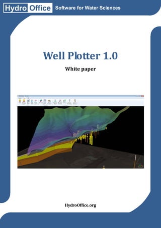
visual analysis and interpretation of drilling data using 1D, 2D and 3D visualization. This program
was developed for fast easy use of modern technology, and, 99% of our visualizations are created as
hardware accelerated vector graphics.
The Well Plotter is released in two editions. The first edition is a basic version which
includes map visualization and data display in 1D Well Log. The second edition features 3D spatial
imaging. It has greater complexity, giving you 2D geological profiles with 3D data display, and the
added advantage of spatial data import from GIS files. Most importantly, you can install a Demo
version, which includes the functionality of both editions. Therefore, you can try the program
before you buy it.
Well Plotter

Input data import
Save project file
1D Well log
2D geological section
3D fence diagram
Visualization export

Well Plotter 3D

Demo version

Yes
Yes
Yes
No
No
Yes

Yes
Yes
Yes
Yes
Yes
Yes

Yes
No
Yes
Yes
Yes
No
Tool User Interface
The program’s user interface was designed for fast efficient work, and it is controlled by a
ribbon toolbar and auxiliary panels. The ribbon toolbar is dynamic and always displays the features
you are currently using. Individual application panels manage all data in your project. There are
separate visualizations of 2D geological sections together with all data related to wells and
boreholes. You can save your prepared project to file while you are working on it, and it is always
available at later stages when you continue work or if you want to refer to it.
Data Types
This program allows you to work with all variable data types. These include technical well
diagrams, geological rock descriptions, numerical measurements, tectonic data, text descriptions,
images and photos and point measurement time series at your predefined depths. Data preparation
in this program is very simple. You can create input data directly using the built-in editors, by
importing CSV files or directly from spreadsheets using “Copy-Paste”; so that all these features
greatly speed up your work. Creation of 2D geological sections is simple. You just need to use the
built-in editor. For 3D visualization, you can directly import ESRI Shape Files with spatial data,
together with Grids
2D Cross Sections / Geological Schemes
The 3D edition of this program also includes functions for displaying data in 2D space. This
feature allows you to display combined 2D sections of two wells. In addition to all the geological
schemes, the program also lets you create 2D heat-maps from imported numerical data. This can be
combined with drilling data to create the 2D schemes from any number of wells and 2D sections in
one single diagram.
3D View / 3D Fence diagrams
The 3D Program Edition also gives you the ability to create dynamic 3D visualizations using
combined data from boreholes and wells, and from 2D geological sections and GIS spatial data. All
data can be arbitrarily combined and visually edited, so that each object in your rendered 3D scene
is freely available.
Conclusion
Our new Well Plotter and Well Plotter 3D programs allow you to display, analyze and
process variable data from boreholes and wells. You can import as much data as you wish into the
program and render it in impressive visualizations. The basic program edition lets you create 1D
Well Logs, while the extended 3D Edition has data visualizations in 2D and 3D space.
These programs are suitable for practical use in hydrogeology, engineering geology and
geotechnics. The beauty of our offer is that you can test the Demo version, which contains all
functionality before buying the program. In addition, everything you need to know to effortlessly
work with the program is contained on our webpage at http://hydrooffice.org.
Finally, the following pages demonstrate examples of the great results you obtain working
with the Well Plotter software.
Well Plotter Software Visualizes Borehole & Well Data

More Related Content

Similar to Well Plotter Software Visualizes Borehole & Well Data

GeoScene3D Newsletter release version 630
GeoScene3D Newsletter release version 630GeoScene3D Newsletter release version 630
GeoScene3D Newsletter release version 630TomMartlevPallesen
 
Interim Report.docx - vsiogap3d.googlecode.com
Interim Report.docx - vsiogap3d.googlecode.comInterim Report.docx - vsiogap3d.googlecode.com
Interim Report.docx - vsiogap3d.googlecode.combutest
 
AutoCad 2D shortcut Keys
AutoCad 2D shortcut KeysAutoCad 2D shortcut Keys
AutoCad 2D shortcut KeysNzar Braim
 
Autocad_Powerpoint_Presentation.new.pdf
Autocad_Powerpoint_Presentation.new.pdfAutocad_Powerpoint_Presentation.new.pdf
Autocad_Powerpoint_Presentation.new.pdfsunilreddypapijenni
 
Software Assignment
Software AssignmentSoftware Assignment
Software Assignmentashleyyeap
 
Exploration and 3D GIS Software - MapInfo Professional Discover3D 2015
Exploration and 3D GIS Software - MapInfo Professional Discover3D 2015Exploration and 3D GIS Software - MapInfo Professional Discover3D 2015
Exploration and 3D GIS Software - MapInfo Professional Discover3D 2015Prakher Hajela Saxena
 
UrbanoVisio_leaflet
UrbanoVisio_leafletUrbanoVisio_leaflet
UrbanoVisio_leafletMihael Vaic
 
Pipeline Isometric Drawings Software: A Complete Guide
Pipeline Isometric Drawings Software:  A Complete GuidePipeline Isometric Drawings Software:  A Complete Guide
Pipeline Isometric Drawings Software: A Complete GuideManaswiMumbarkar
 
Top 10 AutoCAD Facts You Need to Know
Top 10 AutoCAD Facts You Need to KnowTop 10 AutoCAD Facts You Need to Know
Top 10 AutoCAD Facts You Need to Knowkavyagaur3
 
Computer applications in architecture
Computer applications in architectureComputer applications in architecture
Computer applications in architectureDipitaGupta
 
Newsletter GeoScene3D release version 11 0_0_630
Newsletter GeoScene3D release version 11 0_0_630Newsletter GeoScene3D release version 11 0_0_630
Newsletter GeoScene3D release version 11 0_0_630TomMartlevPallesen
 
Software full
Software fullSoftware full
Software fullahmong4
 
Using Geotechnical Data in a 3D Space Whitepaper
Using Geotechnical Data in a 3D Space WhitepaperUsing Geotechnical Data in a 3D Space Whitepaper
Using Geotechnical Data in a 3D Space WhitepaperAmy Heffner
 
“Analysis and Planning of Residential Building by Using AutoCAD and Revit.”
“Analysis and Planning of Residential Building by Using AutoCAD and Revit.”“Analysis and Planning of Residential Building by Using AutoCAD and Revit.”
“Analysis and Planning of Residential Building by Using AutoCAD and Revit.”IRJET Journal
 
2D to 3D dynamic modeling of architectural plans in Augmented Reality
2D to 3D dynamic modeling of architectural plans in Augmented Reality2D to 3D dynamic modeling of architectural plans in Augmented Reality
2D to 3D dynamic modeling of architectural plans in Augmented RealityIRJET Journal
 
Enhancing usability and utility of USGS 3D Elevation Program (3DEP) lidar dat...
Enhancing usability and utility of USGS 3D Elevation Program (3DEP) lidar dat...Enhancing usability and utility of USGS 3D Elevation Program (3DEP) lidar dat...
Enhancing usability and utility of USGS 3D Elevation Program (3DEP) lidar dat...OpenTopography Facility
 

Similar to Well Plotter Software Visualizes Borehole & Well Data (20)

autocad.pptx
autocad.pptxautocad.pptx
autocad.pptx
 
GeoScene3D Newsletter release version 630
GeoScene3D Newsletter release version 630GeoScene3D Newsletter release version 630
GeoScene3D Newsletter release version 630
 
Interim Report.docx - vsiogap3d.googlecode.com
Interim Report.docx - vsiogap3d.googlecode.comInterim Report.docx - vsiogap3d.googlecode.com
Interim Report.docx - vsiogap3d.googlecode.com
 
AutoCad 2D shortcut Keys
AutoCad 2D shortcut KeysAutoCad 2D shortcut Keys
AutoCad 2D shortcut Keys
 
Autocad_Powerpoint_Presentation.new.pdf
Autocad_Powerpoint_Presentation.new.pdfAutocad_Powerpoint_Presentation.new.pdf
Autocad_Powerpoint_Presentation.new.pdf
 
Software Assignment
Software AssignmentSoftware Assignment
Software Assignment
 
Exploration and 3D GIS Software - MapInfo Professional Discover3D 2015
Exploration and 3D GIS Software - MapInfo Professional Discover3D 2015Exploration and 3D GIS Software - MapInfo Professional Discover3D 2015
Exploration and 3D GIS Software - MapInfo Professional Discover3D 2015
 
UrbanoVisio_leaflet
UrbanoVisio_leafletUrbanoVisio_leaflet
UrbanoVisio_leaflet
 
Pipeline Isometric Drawings Software: A Complete Guide
Pipeline Isometric Drawings Software:  A Complete GuidePipeline Isometric Drawings Software:  A Complete Guide
Pipeline Isometric Drawings Software: A Complete Guide
 
AutoCad
AutoCadAutoCad
AutoCad
 
Top 10 AutoCAD Facts You Need to Know
Top 10 AutoCAD Facts You Need to KnowTop 10 AutoCAD Facts You Need to Know
Top 10 AutoCAD Facts You Need to Know
 
Computer applications in architecture
Computer applications in architectureComputer applications in architecture
Computer applications in architecture
 
Software
SoftwareSoftware
Software
 
Newsletter GeoScene3D release version 11 0_0_630
Newsletter GeoScene3D release version 11 0_0_630Newsletter GeoScene3D release version 11 0_0_630
Newsletter GeoScene3D release version 11 0_0_630
 
Software full
Software fullSoftware full
Software full
 
Using Geotechnical Data in a 3D Space Whitepaper
Using Geotechnical Data in a 3D Space WhitepaperUsing Geotechnical Data in a 3D Space Whitepaper
Using Geotechnical Data in a 3D Space Whitepaper
 
“Analysis and Planning of Residential Building by Using AutoCAD and Revit.”
“Analysis and Planning of Residential Building by Using AutoCAD and Revit.”“Analysis and Planning of Residential Building by Using AutoCAD and Revit.”
“Analysis and Planning of Residential Building by Using AutoCAD and Revit.”
 
Software Report
Software ReportSoftware Report
Software Report
 
2D to 3D dynamic modeling of architectural plans in Augmented Reality
2D to 3D dynamic modeling of architectural plans in Augmented Reality2D to 3D dynamic modeling of architectural plans in Augmented Reality
2D to 3D dynamic modeling of architectural plans in Augmented Reality
 
Enhancing usability and utility of USGS 3D Elevation Program (3DEP) lidar dat...
Enhancing usability and utility of USGS 3D Elevation Program (3DEP) lidar dat...Enhancing usability and utility of USGS 3D Elevation Program (3DEP) lidar dat...
Enhancing usability and utility of USGS 3D Elevation Program (3DEP) lidar dat...
 

Recently uploaded

Axa Assurance Maroc - Insurer Innovation Award 2024
Axa Assurance Maroc - Insurer Innovation Award 2024Axa Assurance Maroc - Insurer Innovation Award 2024
Axa Assurance Maroc - Insurer Innovation Award 2024The Digital Insurer
 
IAC 2024 - IA Fast Track to Search Focused AI Solutions
IAC 2024 - IA Fast Track to Search Focused AI SolutionsIAC 2024 - IA Fast Track to Search Focused AI Solutions
IAC 2024 - IA Fast Track to Search Focused AI SolutionsEnterprise Knowledge
 
Tata AIG General Insurance Company - Insurer Innovation Award 2024
Tata AIG General Insurance Company - Insurer Innovation Award 2024Tata AIG General Insurance Company - Insurer Innovation Award 2024
Tata AIG General Insurance Company - Insurer Innovation Award 2024The Digital Insurer
 
Driving Behavioral Change for Information Management through Data-Driven Gree...
Driving Behavioral Change for Information Management through Data-Driven Gree...Driving Behavioral Change for Information Management through Data-Driven Gree...
Driving Behavioral Change for Information Management through Data-Driven Gree...Enterprise Knowledge
 
Factors to Consider When Choosing Accounts Payable Services Providers.pptx
Factors to Consider When Choosing Accounts Payable Services Providers.pptxFactors to Consider When Choosing Accounts Payable Services Providers.pptx
Factors to Consider When Choosing Accounts Payable Services Providers.pptxKatpro Technologies
 
How to convert PDF to text with Nanonets
How to convert PDF to text with NanonetsHow to convert PDF to text with Nanonets
How to convert PDF to text with Nanonetsnaman860154
 
08448380779 Call Girls In Friends Colony Women Seeking Men
08448380779 Call Girls In Friends Colony Women Seeking Men08448380779 Call Girls In Friends Colony Women Seeking Men
08448380779 Call Girls In Friends Colony Women Seeking MenDelhi Call girls
 
Salesforce Community Group Quito, Salesforce 101
Salesforce Community Group Quito, Salesforce 101Salesforce Community Group Quito, Salesforce 101
Salesforce Community Group Quito, Salesforce 101Paola De la Torre
 
Raspberry Pi 5: Challenges and Solutions in Bringing up an OpenGL/Vulkan Driv...
Raspberry Pi 5: Challenges and Solutions in Bringing up an OpenGL/Vulkan Driv...Raspberry Pi 5: Challenges and Solutions in Bringing up an OpenGL/Vulkan Driv...
Raspberry Pi 5: Challenges and Solutions in Bringing up an OpenGL/Vulkan Driv...Igalia
 
A Call to Action for Generative AI in 2024
A Call to Action for Generative AI in 2024A Call to Action for Generative AI in 2024
A Call to Action for Generative AI in 2024Results
 
Data Cloud, More than a CDP by Matt Robison
Data Cloud, More than a CDP by Matt RobisonData Cloud, More than a CDP by Matt Robison
Data Cloud, More than a CDP by Matt RobisonAnna Loughnan Colquhoun
 
The Codex of Business Writing Software for Real-World Solutions 2.pptx
The Codex of Business Writing Software for Real-World Solutions 2.pptxThe Codex of Business Writing Software for Real-World Solutions 2.pptx
The Codex of Business Writing Software for Real-World Solutions 2.pptxMalak Abu Hammad
 
TrustArc Webinar - Stay Ahead of US State Data Privacy Law Developments
TrustArc Webinar - Stay Ahead of US State Data Privacy Law DevelopmentsTrustArc Webinar - Stay Ahead of US State Data Privacy Law Developments
TrustArc Webinar - Stay Ahead of US State Data Privacy Law DevelopmentsTrustArc
 
The 7 Things I Know About Cyber Security After 25 Years | April 2024
The 7 Things I Know About Cyber Security After 25 Years | April 2024The 7 Things I Know About Cyber Security After 25 Years | April 2024
The 7 Things I Know About Cyber Security After 25 Years | April 2024Rafal Los
 
2024: Domino Containers - The Next Step. News from the Domino Container commu...
2024: Domino Containers - The Next Step. News from the Domino Container commu...2024: Domino Containers - The Next Step. News from the Domino Container commu...
2024: Domino Containers - The Next Step. News from the Domino Container commu...Martijn de Jong
 
Boost PC performance: How more available memory can improve productivity
Boost PC performance: How more available memory can improve productivityBoost PC performance: How more available memory can improve productivity
Boost PC performance: How more available memory can improve productivityPrincipled Technologies
 
The Role of Taxonomy and Ontology in Semantic Layers - Heather Hedden.pdf
The Role of Taxonomy and Ontology in Semantic Layers - Heather Hedden.pdfThe Role of Taxonomy and Ontology in Semantic Layers - Heather Hedden.pdf
The Role of Taxonomy and Ontology in Semantic Layers - Heather Hedden.pdfEnterprise Knowledge
 
Injustice - Developers Among Us (SciFiDevCon 2024)
Injustice - Developers Among Us (SciFiDevCon 2024)Injustice - Developers Among Us (SciFiDevCon 2024)
Injustice - Developers Among Us (SciFiDevCon 2024)Allon Mureinik
 
Apidays Singapore 2024 - Building Digital Trust in a Digital Economy by Veron...
Apidays Singapore 2024 - Building Digital Trust in a Digital Economy by Veron...Apidays Singapore 2024 - Building Digital Trust in a Digital Economy by Veron...
Apidays Singapore 2024 - Building Digital Trust in a Digital Economy by Veron...apidays
 
GenCyber Cyber Security Day Presentation
GenCyber Cyber Security Day PresentationGenCyber Cyber Security Day Presentation
GenCyber Cyber Security Day PresentationMichael W. Hawkins
 

Recently uploaded (20)

Axa Assurance Maroc - Insurer Innovation Award 2024
Axa Assurance Maroc - Insurer Innovation Award 2024Axa Assurance Maroc - Insurer Innovation Award 2024
Axa Assurance Maroc - Insurer Innovation Award 2024
 
IAC 2024 - IA Fast Track to Search Focused AI Solutions
IAC 2024 - IA Fast Track to Search Focused AI SolutionsIAC 2024 - IA Fast Track to Search Focused AI Solutions
IAC 2024 - IA Fast Track to Search Focused AI Solutions
 
Tata AIG General Insurance Company - Insurer Innovation Award 2024
Tata AIG General Insurance Company - Insurer Innovation Award 2024Tata AIG General Insurance Company - Insurer Innovation Award 2024
Tata AIG General Insurance Company - Insurer Innovation Award 2024
 
Driving Behavioral Change for Information Management through Data-Driven Gree...
Driving Behavioral Change for Information Management through Data-Driven Gree...Driving Behavioral Change for Information Management through Data-Driven Gree...
Driving Behavioral Change for Information Management through Data-Driven Gree...
 
Factors to Consider When Choosing Accounts Payable Services Providers.pptx
Factors to Consider When Choosing Accounts Payable Services Providers.pptxFactors to Consider When Choosing Accounts Payable Services Providers.pptx
Factors to Consider When Choosing Accounts Payable Services Providers.pptx
 
How to convert PDF to text with Nanonets
How to convert PDF to text with NanonetsHow to convert PDF to text with Nanonets
How to convert PDF to text with Nanonets
 
08448380779 Call Girls In Friends Colony Women Seeking Men
08448380779 Call Girls In Friends Colony Women Seeking Men08448380779 Call Girls In Friends Colony Women Seeking Men
08448380779 Call Girls In Friends Colony Women Seeking Men
 
Salesforce Community Group Quito, Salesforce 101
Salesforce Community Group Quito, Salesforce 101Salesforce Community Group Quito, Salesforce 101
Salesforce Community Group Quito, Salesforce 101
 
Raspberry Pi 5: Challenges and Solutions in Bringing up an OpenGL/Vulkan Driv...
Raspberry Pi 5: Challenges and Solutions in Bringing up an OpenGL/Vulkan Driv...Raspberry Pi 5: Challenges and Solutions in Bringing up an OpenGL/Vulkan Driv...
Raspberry Pi 5: Challenges and Solutions in Bringing up an OpenGL/Vulkan Driv...
 
A Call to Action for Generative AI in 2024
A Call to Action for Generative AI in 2024A Call to Action for Generative AI in 2024
A Call to Action for Generative AI in 2024
 
Data Cloud, More than a CDP by Matt Robison
Data Cloud, More than a CDP by Matt RobisonData Cloud, More than a CDP by Matt Robison
Data Cloud, More than a CDP by Matt Robison
 
The Codex of Business Writing Software for Real-World Solutions 2.pptx
The Codex of Business Writing Software for Real-World Solutions 2.pptxThe Codex of Business Writing Software for Real-World Solutions 2.pptx
The Codex of Business Writing Software for Real-World Solutions 2.pptx
 
TrustArc Webinar - Stay Ahead of US State Data Privacy Law Developments
TrustArc Webinar - Stay Ahead of US State Data Privacy Law DevelopmentsTrustArc Webinar - Stay Ahead of US State Data Privacy Law Developments
TrustArc Webinar - Stay Ahead of US State Data Privacy Law Developments
 
The 7 Things I Know About Cyber Security After 25 Years | April 2024
The 7 Things I Know About Cyber Security After 25 Years | April 2024The 7 Things I Know About Cyber Security After 25 Years | April 2024
The 7 Things I Know About Cyber Security After 25 Years | April 2024
 
2024: Domino Containers - The Next Step. News from the Domino Container commu...
2024: Domino Containers - The Next Step. News from the Domino Container commu...2024: Domino Containers - The Next Step. News from the Domino Container commu...
2024: Domino Containers - The Next Step. News from the Domino Container commu...
 
Boost PC performance: How more available memory can improve productivity
Boost PC performance: How more available memory can improve productivityBoost PC performance: How more available memory can improve productivity
Boost PC performance: How more available memory can improve productivity
 
The Role of Taxonomy and Ontology in Semantic Layers - Heather Hedden.pdf
The Role of Taxonomy and Ontology in Semantic Layers - Heather Hedden.pdfThe Role of Taxonomy and Ontology in Semantic Layers - Heather Hedden.pdf
The Role of Taxonomy and Ontology in Semantic Layers - Heather Hedden.pdf
 
Injustice - Developers Among Us (SciFiDevCon 2024)
Injustice - Developers Among Us (SciFiDevCon 2024)Injustice - Developers Among Us (SciFiDevCon 2024)
Injustice - Developers Among Us (SciFiDevCon 2024)
 
Apidays Singapore 2024 - Building Digital Trust in a Digital Economy by Veron...
Apidays Singapore 2024 - Building Digital Trust in a Digital Economy by Veron...Apidays Singapore 2024 - Building Digital Trust in a Digital Economy by Veron...
Apidays Singapore 2024 - Building Digital Trust in a Digital Economy by Veron...
 
GenCyber Cyber Security Day Presentation
GenCyber Cyber Security Day PresentationGenCyber Cyber Security Day Presentation
GenCyber Cyber Security Day Presentation
 

Well Plotter Software Visualizes Borehole & Well Data

  • 1. Hydro Office Software for Water Sciences Well Plotter 1.0 White paper HydroOffice.org
  • 2. White paper for Well Plotter software. © Miloš Gregor, PhD. / milos.gregor@hydrooffice.org HydroOffice.org – software for water science This file is published under Creative Common License
  • 3. What is HydroOffice HydroOffice is a comprehensive software package designed for hydrology, hydrogeology, meteorology and environmental engineers. The HydroOffice package contains a number of separate installable tools which are distributed as freeware or are priced. Each tool is designed for a specific purpose, and these include; • recession curve analysis of springs and rivers • evaluation and analysis of extreme water conditions as in drought and flood • production of flow duration curves • calculation of minimum and maximum N-daily values • baseflow separation • separation of runoff components from recession curve analysis results • calculation of long-term average groundwater runoff from basins • time series analysis, editing, processing, visualization, evaluation and export • geochemical visualizations • 1D, 2D and 3D visualization of borehole and well data What Is Well Plotter Well Plotter is our latest tool in the HydroOffice software package. Its main function is visual analysis and interpretation of drilling data using 1D, 2D and 3D visualization. This program was developed for fast easy use of modern technology, and, 99% of our visualizations are created as hardware accelerated vector graphics. The Well Plotter is released in two editions. The first edition is a basic version which includes map visualization and data display in 1D Well Log. The second edition features 3D spatial imaging. It has greater complexity, giving you 2D geological profiles with 3D data display, and the added advantage of spatial data import from GIS files. Most importantly, you can install a Demo version, which includes the functionality of both editions. Therefore, you can try the program before you buy it. Well Plotter Input data import Save project file 1D Well log 2D geological section 3D fence diagram Visualization export Well Plotter 3D Demo version Yes Yes Yes No No Yes Yes Yes Yes Yes Yes Yes Yes No Yes Yes Yes No
  • 4. Tool User Interface The program’s user interface was designed for fast efficient work, and it is controlled by a ribbon toolbar and auxiliary panels. The ribbon toolbar is dynamic and always displays the features you are currently using. Individual application panels manage all data in your project. There are separate visualizations of 2D geological sections together with all data related to wells and boreholes. You can save your prepared project to file while you are working on it, and it is always available at later stages when you continue work or if you want to refer to it.
  • 5. Data Types This program allows you to work with all variable data types. These include technical well diagrams, geological rock descriptions, numerical measurements, tectonic data, text descriptions, images and photos and point measurement time series at your predefined depths. Data preparation in this program is very simple. You can create input data directly using the built-in editors, by importing CSV files or directly from spreadsheets using “Copy-Paste”; so that all these features greatly speed up your work. Creation of 2D geological sections is simple. You just need to use the built-in editor. For 3D visualization, you can directly import ESRI Shape Files with spatial data, together with Grids
  • 6.
  • 7. 2D Cross Sections / Geological Schemes The 3D edition of this program also includes functions for displaying data in 2D space. This feature allows you to display combined 2D sections of two wells. In addition to all the geological schemes, the program also lets you create 2D heat-maps from imported numerical data. This can be combined with drilling data to create the 2D schemes from any number of wells and 2D sections in one single diagram.
  • 8. 3D View / 3D Fence diagrams The 3D Program Edition also gives you the ability to create dynamic 3D visualizations using combined data from boreholes and wells, and from 2D geological sections and GIS spatial data. All data can be arbitrarily combined and visually edited, so that each object in your rendered 3D scene is freely available.
  • 9.
  • 10. Conclusion Our new Well Plotter and Well Plotter 3D programs allow you to display, analyze and process variable data from boreholes and wells. You can import as much data as you wish into the program and render it in impressive visualizations. The basic program edition lets you create 1D Well Logs, while the extended 3D Edition has data visualizations in 2D and 3D space. These programs are suitable for practical use in hydrogeology, engineering geology and geotechnics. The beauty of our offer is that you can test the Demo version, which contains all functionality before buying the program. In addition, everything you need to know to effortlessly work with the program is contained on our webpage at http://hydrooffice.org. Finally, the following pages demonstrate examples of the great results you obtain working with the Well Plotter software.