Bridging Services, Information and Data for Europe
•
1 like•253 views

Karel Janecka, Otakar Cerba, Radek Fiala, Karel Jedlicka, Jan Jezek: BRISEIDE - BRIdging SErvices, Information and Data for Europe (poster), 9th International Symposium GIS Ostrava, VŠB – Technical Univerzity of Ostrava, from 23rd to 25th January 2012

Recommended
More Related Content
Viewers also liked
Viewers also liked (8)
Similar to Bridging Services, Information and Data for Europe
Similar to Bridging Services, Information and Data for Europe (20)
More from GeoCommunity
More from GeoCommunity (8)
Recently uploaded
Recently uploaded (20)
Bridging Services, Information and Data for Europe
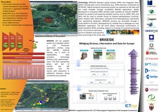
- 1. The product: Technology: BRISEIDE develops spatial analysis WPSs and integrates them • time-aware extension of data within existing open source frameworks (e.g., WPS extension of Sextante by models developed in the context 52°North). Spatio-temporal processing services are exposed via the web and of previous / ongoing EU INSPIRE are made available through compatible WebGIS applications. Newly related projects developed or protypical OWSs already made available by relevant INSPIRE- • application (e.g. Civil Protection, related EU projects and exposing standard services such as WMS, WCS and access to sensor-data) based on WFS, will be used to provide access to relevant geodatabases, enriched, the integration of existing, user when needed, with information, extracted from heterogeneous, distributed operational information user operational databases. BRISEIDE services are accessible through a • value added services multi-platform 3D client, developed by FG, invoked from a webpage as a Java for spatio-temporal data management WebStart application. The 3D client allows interactive orchestration of spatio-temporal WPSs providing support to chaining of required processing units. This ensures interactive access to datasets and asynchro- nous processing at the server side. CLC CLC CLC Application/validation of the product: 1990 2000 2006 1990 2000 2006 BRISEIDE will be applied, BRISEIDE Forest Forest tested and validated within BRIdging SErvices, Information and Data for Europe Forest a Civil Protection BRISEIDE’s application context, using BRISEIDE APPLICATION LEVEL Spatio-temporal Services the INSPIRE relevant Mobile users Desktop users Operators themes, via a chain of BRISEIDE Pilots Smart, stakeholders, data context aware BRISEIDE Value added services providers, technology services partners, and downstream Technologies EU Projects (data & services) users. The Pilot operational phase will last 12 ORCHESTRA architecture months and will BRISEIDE MIDDLEWARE LEVEL Medisolae EU Project NAUTILUS (SinerGIS) WPS Library PyWPS Plan4All EU Project GIS4EU EU Project NatureSDIPlus EU GeoPortal (CCSS) 3D Geobrowser Service Orchestration and Chaining Flexible consider real life (Graphitech) adaptation to real Project events, with extensions in (CCSS) BRISEIDE Geoprocessing Services world additional domains, being WCPS WPS requirements considered and assessed. Existing base services common description WMS WFS WCS of the information bridge the gap BRISEIDE between BRISEIDE DATA & PERSISTENCY LEVEL Different data JANECKA Karel 1, CERBA Otakar, repositories Sensor Networks Data sets from previous EU FIALA Radek, JEDLICKA Karel, projects JEZEK Jan Department of Mathematics Section of Geomatics Faculty of Applied Sciences University of West Bohemia Pilsen, Czech Republic 1kjanecka@kma.zcu.cz BRISEIDE is supported by the CIP / ICT Policy Support Programme of the European Commission.