
Recommended
More Related Content
Similar to The Role of Cartography in the Promotion of Rail Travel to Yellowstone National Park
Similar to The Role of Cartography in the Promotion of Rail Travel to Yellowstone National Park (20)
Recently uploaded
Recently uploaded (20)
The Role of Cartography in the Promotion of Rail Travel to Yellowstone National Park
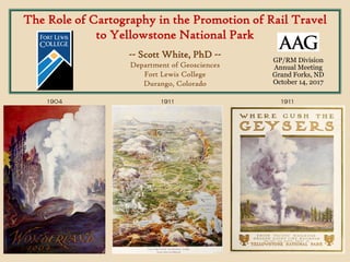
- 1. The Role of Cartography in the Promotion of Rail Travel to Yellowstone National Park -- Scott White, PhD -- Department of Geosciences Fort Lewis College Durango, Colorado 1904 1911 1911 GP/RM Division Annual Meeting Grand Forks, ND October 14, 2017
- 2. The World’s First National Park Forty-Second Congress of the United States of America; At the Second Session, Dec. 4, 1871. An Act to set apart a certain Tract of Land lying near the Head-waters of the Yellowstone River as a public Park. Be it enacted by the Senate and House of Representatives of the United States of America in Congress assembled, That the tract of land in the Territories of Montana and Wyoming, lying near the headwaters of the Yellowstone River … is hereby reserved and withdrawn from settlement, occupancy, or sale under the laws of the United States, and dedicated and set apart as a public park or pleasuring- ground for the benefit and enjoyment of the people … Forty-Second Congress of the United States of America; At the Second Session, Dec. 4, 1871. An Act to set apart a certain Tract of Land lying near the Head-waters of the Yellowstone River as a public Park. Be it enacted by the Senate and House of Representatives of the United States of America in Congress assembled, That the tract of land in the Territories of Montana and Wyoming, lying near the headwaters of the Yellowstone River … is hereby reserved and withdrawn from settlement, occupancy, or sale under the laws of the United States, and dedicated and set apart as a public park or pleasuring- ground for the benefit and enjoyment of the people … The Act was passed by Congress and signed into law by President Ulysses S. Grant on March 1, 1872.
- 3. http://wyomingplaces.pbworks.com from: Preliminary Report of the United States Geological Survey of Montana and Portions of Adjacent Territories; Being a Fifth Annual Report of Progress. F. V. Hayden, United States Geologist Washington: 1872
- 4. 1912? Library of Congress Geography and Map Division Washington, DC G4262.Y4P3 190- .P7 TIL Waite (2006) describes more than 19 proposed railroads to gateway towns as well as to locations inside the park. The railroad from Gardiner to Cooke City shown in this map was never built.
- 5. “Tally-Ho” stagecoach at the Gardiner, Montana, Train Depot, 1904 (photographer unknown) https://www.nps.gov/features/yell/slidefile
- 6. To Yellowstone by Rail • 5 branch lines of main railroads reached Yellowstone gateway towns… 1883/1903-1976 Cinnabar/Gardiner, MT North Entrance 1912-1956 Cody, WY East Entrance 1908-1960 W. Yellowstone, MT West Entrance 1927-1961 Gallatin Gateway, MT Northwest Entrance 1922-1934 Lander, WY South Entrance
- 7. https://www.davidrumsey.com - Cartography Associates 1887 Printers and Engravers: Poole Bros. (brochure)/Rand, McNally & Co. (map on reserve) approx. 8.25” x 3.75” (two panels)
- 8. https://www.davidrumsey.com - Cartography Associates 1887 Printers and Engravers: Poole Bros. (brochure on reverse)/Rand, McNally & Co. (map) approx. 34.5” x 16.5” (unfolded)
- 10. “The logical and convenient entrance to the park (from natural and geographical standpoints), is from the north by way of Livingston, the Gate of the Mountains, and the Upper Yellowstone River to Gardiner. The Northern Pacific is the only line to Gardiner, the oldest and original entrance to the park, made impressive and commanding as the chief gateway to this great pleasure ground by the Government Lava Arch.” (“Yellowstone National Park Via Gardiner Gateway” brochure, Northern Pacific, 1917) https://archive.org/details/yellowstoneparkv300gnort
- 11. “When you plan to go, don’t think of the Park alone. Investigate superiority of route and train service and your decision will lead you to Yellowstone Station, the Western Entrance to the Park, reached only by the Union Pacific System, the popular and direct Yellowstone Route.” (“Yellowstone National Park” brochure, Union Pacific System, 1917) - right 1915 https://archive.org/details/yellowstonenatio73yell https://archive.org/details/yellowstonen1917302unio
- 12. Trip Preplanning using a Railroad Network Map from Burlington Route Timetables (Poole Bros. 1948) http://streamlinermemories.info/Zephyr/B48TT.pdf
- 13. Trip Preplanning using a Railroad Network Map from Burlington Route Timetables (Poole Bros. 1948) http://streamlinermemories.info/Zephyr/B48TT.pdf • network maps were most useful when viewed along with timetables • linear cartograms with accurate geography deemphasized • visualization of railroad network, connections, stations, and hub cities • rival railroads often not depicted…
- 14. Trip Preplanning using a Railroad Network Map from Burlington Route Timetables (Poole Bros. 1948) http://streamlinermemories.info/Zephyr/B48TT.pdf
- 15. Trip Preplanning using a Railroad Network Map from Wonderland 1904 (Book published by Rand McNally 1904; Map by Poole Bros. 1903) Newberry Library Ayer F597 .W87
- 16. Touring in Yellowstone using a Destination Map of the Park Alice’s Adventures in the New Wonderland (Poole Bros. 1884) approx. 25” x 18.5” (unfolded) Newberry Library G4262.Y4 1884 .H3
- 18. Alice’s Adventures in the New Wonderland (Poole Bros. 1884) approx. 25” x 18.5” (unfolded) Newberry Library G4262.Y4 1884 .H3
- 19. Touring in Yellowstone using a Destination Map of the Park The Way to Wonderland Yellowstone National Park 1924 (no publisher listed) 138.H.4.2F Box 1 1922-1925 Gale Family Library Minnesota Historical Society
- 20. Touring in Yellowstone using a Destination Map of the Park
- 21. Poole Bros. Inc. Railway Printers Chicago, Illinois George A. Poole (1843-1918) Detail from Birds-Eye View of the Business District of Chicago (Poole Bros. 1898) Newberry Library G4104.C6A3 1898 .P6 from The Inland Printer (October 1918) Established in Chicago in 1870 by George A. and William H. Poole, Poole Bros. was at one time the largest printer in the U.S. exclusively engaged in printing for the transportation industry, mainly the railroads. (The Inland Printer, 1918). The company remained in business into the 1970s.
- 22. Poole Bros. Inc. Railway Printers Chicago, Illinois https://archive.org
- 23. Poole Bros. Inc. Railway Printers Chicago, Illinois Library of Congress Geography and Map Division Washington, DC G4104.C6P33 1897 .P6
- 24. Yellowstone National Park. Northern Pacific Railroad (Chas. S. Fee/Poole Bros. 1895) Library of Congress G4262.Y4 1895 .F4 TIL (https://www.loc.gov/item/97683606)
- 25. Where Gush the Geysers. Oregon Short Line Railroad to the Yellowstone National Park. (Poole Bros. 1910) https://archive.org/details/togeyserlandoreg00colb
- 28. Yellowstone National Park Picture Map (Poole Bros. 1928) Newberry Library RMcN AE 190.34
- 29. Yellowstone National Park Picture Map (Poole Bros. 1928) Newberry Library RMcN AE 190.34 https://archive.org/details/togeyserlandoreg00colb
- 30. Wonderland 1905 text by Olin D. Wheeler Wonderland 1904 text by Olin D. Wheeler Wonderland 1901 text by Olin D. Wheeler Wonderland 1900 text by Olin D. Wheeler Book published by Rand McNally. Yellowstone map published by Rand McNally. Newberry Library 5A 4755 Book published by Poole Bros. Yellowstone map published by Poole Bros. Newberry Library 5A 5236 Book published by Rand McNally. Yellowstone map published by Rand McNally. Newberry Library G 89 .971 Book published by Rand McNally. Yellowstone map published by Rand McNally. Newberry Library Ayer F597 .W87
- 31. Wonderland 1905 text by Olin D. Wheeler Book published by Poole Bros. Yellowstone map published by Poole Bros.
- 32. Decline of Rail Travel Rise of Auto Travel • Yellowstone visitors during the summer of 1915… 44,477 arrived by rail 7,418 arrived by private automobile (source: Runte, 1984) photo source: Gallatin History Museum, Bozeman, MT
- 33. Decline of Rail Travel Rise of Auto Travel • Yellowstone visitors during the summer of 1930… 26,845 arrived by rail 194,771 arrived by private automobile Automobile stuck in dirt road, 1925 (photographer unknown) https://www.nps.gov/features/yell/slidefile (source: Runte, 1984)
- 34. Decline of Rail Travel Rise of Auto Travel Union Pacific Railroad - Poole Bros (1953) author’s personal collection
- 35. Decline of Rail Travel Rise of Auto Travel
- 37. Photograph by Andrew H. Brown, National Geographic Society, 1950 http://www.nationalgeographic.com/travel/national-parks/classic-yellowstone-photos/
- 38. Summary • Railroads were integral to the development and promotion of Yellowstone National Park for nearly 70 years (1880s-1940s). • Network maps in brochures and timetables were useful for trip preplanning by the potential tourist. • Destination maps in brochures and booklets were useful for routing and navigation once the tourist had arrived. • Cartographic skill varied with the quality of the brochure or booklet housing the maps. Poole Bros. of Chicago were one of the most talented of the railway advertising publishers. • The decline of rail travel after WWII can be seen in the decline of railway travel promotional literature and their accompanying maps.
- 39. References and Acknowledgments • Butler, W. B. 2007. Railroads in the national parks. Washington, DC: National Park Service. https://www.nps.gov/parkhistory/online_books/nps/railroads.pdf • Runte, A. 1984. Trains of discovery: Western railroads and the national parks. Flagstaff, AZ: Northland Press • Trade Notes: George A. Poole Passes Away. 1918. Inland Printer 62 (1):85. • Waite, T. 2006. Yellowstone by train: A history of rail travel to America’s first national park. Missoula, MT: Pictorial Histories Publishing Co. • Mapping, Text, and Travel: A National Endowment for the Humanities Summer Seminar for College and University Faculty, July 11 - August 12, 2016, Newberry Library, Chicago, IL • Newberry Library, Chicago, IL: CB&Q Archives and the Edward E. Ayer Collection • BYU Larsen Yellowstone Collection, Internet Archive (archive.org) • Minnesota Historical Society, Gale Family Library, St. Paul, MN: Northern Pacific Railroad Archives • Library of Congress, Geography and Map Division, Washington, DC • National Park Service, Yellowstone’s Photo Collection (https://www.nps.gov/features/yell/slidefile)