Download to read offline


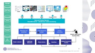

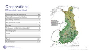


The document provides information about the Finnish Meteorological Institute (FMI) including: - FMI has roughly 650 full-time employees split between research and operational services related to public safety, commercial, and other sectors. - FMI's software development team consists of 40-50 developers working across several units, with all new development done as open source. - In 2013, FMI began openly providing its data in machine-readable formats through an open data portal.


![Fast Cat M V[1]](https://cdn.slidesharecdn.com/ss_thumbnails/fast-cat-m-v13039-thumbnail.jpg?width=640&height=640&fit=bounds)


