CV for Spatial Information Technology Professional
•
1 like•79 views

Sudarshan Singh Parmar is seeking a position that allows him to apply his technical skills and knowledge gained through his education and experience. He holds an M.Tech in Spatial Information Technology from Devi Ahilya University, Indore and a B.E. in Electronics and Communication Engineering from Rajiv Gandhi Technical University, Bhopal. His academic qualifications also include an S.S.C. in Science and an H.S.C. in all subjects. Parmar has one semester of teaching experience and one year of experience maintaining power line communication systems. His areas of interest include control systems, analog circuits, and remote sensing.

Recommended
More Related Content
What's hot
What's hot (20)
Similar to CV for Spatial Information Technology Professional
Similar to CV for Spatial Information Technology Professional (20)
CV for Spatial Information Technology Professional
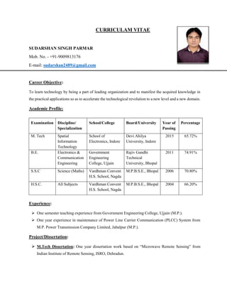
- 1. CURRICULAM VITAE SUDARSHAN SINGH PARMAR Mob. No. - +91-9009813176 E-mail: sudarshan2489@gmail.com Career Objective: To learn technology by being a part of leading organization and to manifest the acquired knowledge in the practical applications so as to accelerate the technological revolution to a new level and a new domain. Academic Profile: Examination Discipline/ Specialization School/College Board/University Year of Passing Percentage M. Tech Spatial Information Technology School of Electronics, Indore Devi Ahilya University, Indore 2015 65.72% B.E. Electronics & Communication Engineering Government Engineering College, Ujjain Rajiv Gandhi Technical University, Bhopal 2011 74.91% S.S.C Science (Maths) Vardhman Convent H.S. School, Nagda M.P.B.S.E., Bhopal 2006 70.80% H.S.C. All Subjects Vardhman Convent H.S. School, Nagda M.P.B.S.E., Bhopal 2004 66.20% Experience: One semester teaching experience from Government Engineering College, Ujjain (M.P.). One year experience in maintenance of Power Line Carrier Communication (PLCC) System from M.P. Power Transmission Company Limited, Jabalpur (M.P.). Project/Dissertation: M.Tech Dissertation: One year dissertation work based on “Microwave Remote Sensing” from Indian Institute of Remote Sensing, ISRO, Dehradun.
- 2. Title- “Spatial analysis of Ground Water depletion and Ground Water depletion induced Land Subsidence scenario in North-West India” Objective- Detection and measurement of land subsidence in ground water depletion hotspots in dense habitation and correlate the groundwater depletion hotspots and land subsidence. Other Projects: Title- “DTMF based data communication system” Objective- Development of a communication system in the big industries have to maintain a large Communication network and provide a better communication facility. Title- “Two way Intercom System” Objective- To design a communication system for point to point communication. Computer Skills: Languages : Core Java, PHP, HTML Software Operated : MATLAB, ArcGIS 10.1, ERDAS Imagine 13, ENVI SARscape 5.0 Operating System : Windows XP/7/8 Surveying Skills: Differential GPS (DGPS) Terrestrial Laser Scanner (TLS) Total Station Training and Programs: Completed one month training in Electronic Circuit Design exposure to Eagle PCB designing software from Scientech Pvt. Ltd., Indore. Completed one month training in “Microcontroller and Interfacing” from Techoz Solution, Indore. Area of Interest: Control System and analog circuit Remote Sensing Achievements: Gate qualified year 2013, 2014 and 2016 UGC NET 2015 qualified for lecturership
- 3. Presented a paper on Microwave Remote Sensing in a National Conference on “Geospatial Technology in Natural Resource Management” held in Ludhiana (Punjab). Strength: Honest Adaptive Quick Learner Personal Details: Declaration: I hereby declare that the above information is complete and true to the best of my knowledge and is sufficient for your kind consideration. Date: SUDARSHAN SINGH PARMAR Place: Name : Sudarshan Singh Parmar S/O Mr. Ramsingh Parmar Date of Birth : 24/06/1989 Marital Status : Unmarried Address : 82/2, Vrandavan Dham Colony, near Mahamratunjay dwar, Ujjain, M.P. Hobbies : Playing Cricket & Chess Language known : English & Hindi