![STONEX HANDHELD GIS
Technical Data Stonex
Technical features Stonex Handheld GIS
System S3 standard configuration
Operating system Microsoft Windows Mobile 6.5 Model Description Q’ty
CPU 600MHz S3 receiver PDA+ GPS Unit 1
GPS Battery 2800mAh battery 1
GPS type 20 channels, L1 frequency, C/A code Charger Batterycharger 1
Hot-start 1s Cable cable with USB port 1
Warm-start 35s Touching pen Stylus 2
Cold-start 42s Plug Charger adapter plug [ AU] 1
Stand-alone accuracy < 2.5 m (CEP, -130 dBm)1 Plug Charger adapter plug [ US] 1
SBAS accuracy 2.0m2 Plug Charger adapter plug [ EU] 1
Velocity accuracy <0.01 m/s (speed) Plug Charger adapter plug [ UK] 1
Heading accuracy <0.01° Charger Car battery charger 1
Time accuracy 1µs or less Antenna External GPS antenna 1
Screen
Screen 3.5' QVGA TFT, sunlight - readable color touch screen
Keyboard sunight visible
Data Communication
Storage 128MB SDRAM, 256MB NAND flash
SD slot Micro SD
Port Mini USB2.0
Bluetooth Bluetooth V2.0,EDR
Power
Battery 2800mAh Li-ion battery
Working time 10h(typical3)
External power 3.3V~5V
Power consumption 0.5W
Physica
Dimension 179.5mm*91.2mm*31.5mm
Weight 250g (Without battery)
Environment
Working temperature -10`C -- +60`C
Storage temperature -30`C -- +70`C
Shock 1.5m drops to concrete
Waterproof/dustproof IEC 529-IP66
Extension
Camera 3 megapixel
Gravity sensor
Cellular modem
Remark
1. 50% 24 hr static, -130 dBm. The actual accuracy depends on the quality of GPS signal
and working environment;
2. SBAS includes WAAS available in North America only, EGNOS available in Europe only,
and MSAS available in Japan only.
3. Typical working status means that GPS works in fixed mode, display backlight is set to be
best suitable for out-field work. Key tone and keyboard backlight is off
STONEX®
info@stonex.it
www.stonex.it](data:image/gif;base64,R0lGODlhAQABAIAAAAAAAP///yH5BAEAAAAALAAAAAABAAEAAAIBRAA7)
Recommended
More Related Content
What's hot
What's hot (19)
Similar to Stonex s3 web
Similar to Stonex s3 web (20)
More from stonexepm
Recently uploaded
Recently uploaded (20)
Stonex s3 web
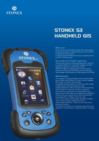
- 1. Stonex STONEX S3 HANDHELD GIS GPS receiver Stonex S3 has an internal high sensitivity GPS module able to fix quickly the position in hostile environments such as forests or high-density urban centers. It supports standard NMEA protocol and a proprietary binary format for GPS data output. Great platform for handheld applications Working under Windows Mobile operating system, Stonex S3 is a powerful platform for mobile GIS, navigation and other applications requiring a compact field computer. Windows Mobile 6.5 operating system includes standard software like Windows Mobile Office and e-mail, allowing a rapid exchange of data between an on field operator and the office. Multi-function The integrated 3 megapixels digital camera provides detailed documentation of the condition of an asset, while the integrated GPS receiver records the asset’s location. Compatibility with high capacity micro SD cards enable storage of large quantity of data and background maps. Integrated Bluetooth, GPRS and wireless LAN modules allow easy connection to networks and others equipment. User experience is extended by connecting Stonex S3 to barcode scanner, RFID readers and portable printer via Bluetooth. Thanks to the built-in gravity sensor, Stonex S3 generates a sound signal when it is falling out from your bag. The 3,5 inches touch screen provides also good readability under intense sun light; in addition Stonex S3 is waterproof/dustproof IP66 certified, as every field-proven equipment should be. The long life removable and rechargeable battery allows data collection for a full working day, without the need for recharging.
- 2. STONEX HANDHELD GIS Technical Data Stonex Technical features Stonex Handheld GIS System S3 standard configuration Operating system Microsoft Windows Mobile 6.5 Model Description Q’ty CPU 600MHz S3 receiver PDA+ GPS Unit 1 GPS Battery 2800mAh battery 1 GPS type 20 channels, L1 frequency, C/A code Charger Batterycharger 1 Hot-start 1s Cable cable with USB port 1 Warm-start 35s Touching pen Stylus 2 Cold-start 42s Plug Charger adapter plug [ AU] 1 Stand-alone accuracy < 2.5 m (CEP, -130 dBm)1 Plug Charger adapter plug [ US] 1 SBAS accuracy 2.0m2 Plug Charger adapter plug [ EU] 1 Velocity accuracy <0.01 m/s (speed) Plug Charger adapter plug [ UK] 1 Heading accuracy <0.01° Charger Car battery charger 1 Time accuracy 1µs or less Antenna External GPS antenna 1 Screen Screen 3.5' QVGA TFT, sunlight - readable color touch screen Keyboard sunight visible Data Communication Storage 128MB SDRAM, 256MB NAND flash SD slot Micro SD Port Mini USB2.0 Bluetooth Bluetooth V2.0,EDR Power Battery 2800mAh Li-ion battery Working time 10h(typical3) External power 3.3V~5V Power consumption 0.5W Physica Dimension 179.5mm*91.2mm*31.5mm Weight 250g (Without battery) Environment Working temperature -10`C -- +60`C Storage temperature -30`C -- +70`C Shock 1.5m drops to concrete Waterproof/dustproof IEC 529-IP66 Extension Camera 3 megapixel Gravity sensor Cellular modem Remark 1. 50% 24 hr static, -130 dBm. The actual accuracy depends on the quality of GPS signal and working environment; 2. SBAS includes WAAS available in North America only, EGNOS available in Europe only, and MSAS available in Japan only. 3. Typical working status means that GPS works in fixed mode, display backlight is set to be best suitable for out-field work. Key tone and keyboard backlight is off STONEX® info@stonex.it www.stonex.it