GEOMETER INTERNATIONAL PRESENTS HIGH PRECISION POSITIONING RTK TECHNOLOGY
•
0 likes•25 views

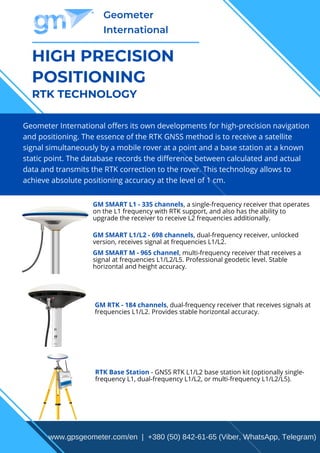
Geometer International offers its own developments for high-precision navigation and positioning. The essence of the RTK GNSS method is to receive a satellite signal simultaneously by a mobile rover at a point and a base station at a known static point. The database records the difference between calculated and actual data and transmits the RTK correction to the rover. This technology allows to achieve absolute positioning accuracy at the level of 1 cm.

Recommended
More Related Content
Similar to GEOMETER INTERNATIONAL PRESENTS HIGH PRECISION POSITIONING RTK TECHNOLOGY
Similar to GEOMETER INTERNATIONAL PRESENTS HIGH PRECISION POSITIONING RTK TECHNOLOGY (20)
More from Vitaly Geometer
More from Vitaly Geometer (8)
Recently uploaded
Recently uploaded (20)
GEOMETER INTERNATIONAL PRESENTS HIGH PRECISION POSITIONING RTK TECHNOLOGY
- 1. HIGH PRECISION POSITIONING RTK TECHNOLOGY Geometer International Geometer International offers its own developments for high-precision navigation and positioning. The essence of the RTK GNSS method is to receive a satellite signal simultaneously by a mobile rover at a point and a base station at a known static point. The database records the difference between calculated and actual data and transmits the RTK correction to the rover. This technology allows to achieve absolute positioning accuracy at the level of 1 cm. GM SMART L1 - 335 channels, a single-frequency receiver that operates on the L1 frequency with RTK support, and also has the ability to upgrade the receiver to receive L2 frequencies additionally. GM SMART L1/L2 - 698 channels, dual-frequency receiver, unlocked version, receives signal at frequencies L1/L2. GM SMART M - 965 channel, multi-frequency receiver that receives a signal at frequencies L1/L2/L5. Professional geodetic level. Stable horizontal and height accuracy. GM RTK - 184 channels, dual-frequency receiver that receives signals at frequencies L1/L2. Provides stable horizontal accuracy. RTK Base Station - GNSS RTK L1/L2 base station kit (optionally single- frequency L1, dual-frequency L1/L2, or multi-frequency L1/L2/L5). www.gpsgeometer.com/en | +380 (50) 842-61-65 (Viber, WhatsApp, Telegram)
- 2. Geometer International RTK equipment is used when absolute coordinate accuracy is required. If consumer navigation systems give an accuracy of 2.5 to tens of meters, then with the help of RTK equipment, an accuracy of 1 cm in real time is achieved. RTK equipment is distinguished by the characteristics and support of one (only GPS) or several satellite systems at once (GPS, GLONASS, GALILEO, BEIDOU, QZSS, IRNSS), which is reflected in the number of "visible" satellites in real time. Also, RTK receivers differ in the support of one or more frequencies, which affects the stability of obtaining RTK accuracy and the speed of obtaining a fixed solution. METHODS FOR OBTAINING CORRECTIONS Own base station - independence from external providers. Own base station transmitting corrections within a radius of 50 km or more. Two or more base stations can be networked with automatic connection to the nearest station during moving the RTK rover. Paid access to the network of base stations. No need to buy your own base station, if you can purchase temporary access to receive corrections. There are options for hourly corrections, daily, weekly, monthly, annual service packages. RTK RECEIVER APPLICATIONS INDUSTRIES OF USE ІOther industries where absolute and repeatable positioning accuracy are important. Geodesy Agriculture Gardening Forestry Landscape design Construction Road construction Utilities Gas production and distribution Oil production and distribution www.gpsgeometer.com/en | +380 (50) 842-61-65 (Viber, WhatsApp, Telegram)
- 3. Geometer International EXAMPLES OF USE BY INDUSTRY: ПРОГРАММНОЕ ОБЕСПЕЧЕНИЕ Geodesy - survey of points, marking works, control of heights, stake-out, control and measuring works, definition of exact borders of territories. Выбор программного обеспечения geometer SCOUT либо SurvX/SurPAD является индивидуальным выбором заказчика, в зависимости от требований к функциям. Agriculture - accurate determination of field boundaries, staking out digital projects, high- precision navigation during field work. Horticulture - high-precision cartography, determining the exact boundaries of gardens, laying out gardens, stakng out digital projects. Forestry - precise definition of territory boundaries, structural digitalization (marking of important and problematic areas). Landscape design - geoinformation landscape mapping, staking out of digital projects. Construction - construction site layout, control and measurement works, structural digitization. Road construction - control and measuring works, structural digitalization. Utilities - high-precision cartography of objects, determination of the volume of work, structural digitization (marks of important and problematic areas). Gas production and distribution - high-precision mapping of objects, structural digitization. Oil production and distribution - high-precision mapping of objects, structural digitization. The choice of geometer SCOUT or SurvX / SurPAD software is the individual choice of the customer, depending on the requirements for the functions. www.gpsgeometer.com/en | +380 (50) 842-61-65 (Viber, WhatsApp, Telegram)