Top Kala Jadu, Black magic expert in Faisalabad and Kala ilam specialist in S...
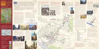
Medieval City Map Side One[1]
1. Glasgow City Council
Daniel Defoe
edieval Glasgow from its beginnings in 1119 with the building of the Cathedral 9 Saltmarket 10 East Port and the Gallowgate
6 Collegiate Church of St Mary of Loreto and St Anne 7& 8 Tolbooth and Steeple
with small windows, which looked onto the
To the left of the Tron Kirk steeple, looking right, down King Street, Standing at Glasgow Cross, Standing at Glasgow Cross,
Continue along the Trongate, you will come to Glasgow Cross,
on the site of St Kentigern's first church, to becoming the seat of an Trongate. It was described as being 66 foot long looking across the street and down to
sat the site of the pre-Reformation Collegiate Church of St Mary and looking right down Saltmarket,
where the Trongate, High Street, Saltmarket, and the Gallowgate meets
archbishopric in 1492 has stirred considerable interest. Glasgow's Medieval Spoutmouth, Gallowgate
(20.12 metres) and 24 feet wide (7.47 metres) deep.
- this was the area of the weekly marketplace. The 17th century Tolbooth we can see what was known in the left is the Gallowgate. Along this
St Anne. Glasgow City Libraries,(Mitchell Library)
Daniel Defoe describes the building, as ornate and
ecclesiastical centre had an important economic impact on the development of the 13th century as the high street. 9 road lay the East Port and further
The church was established in 1525 by James Houston, the sub- Steeple is situated to the left. Originally the steeple would have had a
beautifully carved with Rose and Thistles, “ it hath a still the Gallows.
dean of the cathedral and was situated on the south of the Trongate. Evidence suggests it was already
large tolbooth attached to it, but this was removed in 1921.
the town. When a charter was issued by William the Lion, between 1175 and 1178, giving stately staircase ascending to the Town councils hall, a Little is known of the early east
Although there is crowded with buildings by 1285. You can see in the distance to the right,
Little information is available about the earliest of Glasgow's
Glasgow the status of burgh, the rights it endowed to the burgesses of the city to own land, dean guilds hall, majestraits rooms, collector of the a grand building in the classical style - this is the High Court. The 13th port which stood on the westbank
no evidence to tolbooths, which lay at the northwest corner of the modern High
excise of the town's rooms, these rooms are all vaulted
to trade and hold an annual fair led to the expansion of the town towards the Cathedral. Street and Trongate. A 12th century burgh may well have been of the Molendinar on the road called
suggest the century medieval high street would have stretched only from Glasgow
.... The king's hall is the finest.. In this great building are five large Gallowgate. By the mid 17th century
church's Cross to the High Court.
Glasgow by the 15th century had become a thriving town second only to St Andrew's in expected to have a centre of civil administration, but until 1454 there
rooms appointed for common prisoners”.
architectural style, as the town grew the port was
South of the Cross, the Saltmarket extended to the Briggait or
are no surviving records of its early medieval history. In 1578, the
Glasgow’s Medieval City ecclesiastical importance. The Tollbooth was not just used as an
it did have a burial moved further east. It was called 'Eist
Bridgegate (the road to the bridge). Since the twelfth century,
citys treasury accounts, describes payment , ' gevin to the maister of 10
administrative centre but as a prison for those
The medieval landscape of buildings such as the Bishops Castle and the College, which
development between 1150 and 1550 8
ground and Barras Yett', or ( east barred gate).
Glasgow had been evolving into almost two towns; in the north of
work and debur sit be him upon the biggin of the foir work of the
accused of crimes. The prisoners would have
gardens. The The port had a large stone archway, with heavy nail studded
the town lay the ecclesiastical centre, while in the south around the
dominated the High Street for hundreds of years, now lie hidden beneath Glasgow's Victorian tolbuithe and settin up of the bell'. Other records in the same year
been led to their rooms by a narrow turnpike
townspeople were oak doors, offering the townspeople some security at night and
Cross and the Saltmarket, Glasgow's mercantile centre expanded. The
mention ' gevin David Kay for the pryce of the knok', (clock), 'buithis'
architecture and new developments. I hope that this map will give you a glimpse of this stair in the Tolbooth steeple. The steeple, which
likely to have in case of invasion. Port doors were locked at night and keys
town had received Burgh status in 1175, this gave certain trading
(shops) in the street and repairs to the Tolbooth’s great oak and iron
splendid medieval legacy and that it will encourage you to experience for yourselves this survives today, would have stood at the east of
attended the given to the baillies. The port lay next to the place where, as
rights to the townspeople, allowing them to hold an annual fair and a
door. The T olbooth was evidently a substantial building but by the
the building. The seven story steeple is capped
early 17th century had become
church rather than the name suggests, the condemned were hung outside the city
aspect of Glasgow's archaeological past. weekly market. Before this any trading would have been carried out
with a turreted parapet and beautifully engraved gates. By the mid 18th
the Cathedral. We near to the cathedral, which relied on custom from Pilgrims visiting
'ruinous' and the Town council
Liz Cameron, with a crown and spirelet. The prisoners would
can see that the the cathedral . The commercial medieval centre of the town was century the port was no
decided to rebuild it. The
Lord Provost have been kept on the top floor.
church was however to develop along the Saltmarket, Trongate, Gallowgate and longer in use and the
condition of the building at this
Several alterations and major additions to
supported directly the High Street. gate was levelled, the
time can be seen by the
the tolbooth took place in the succeeding As the burgh grew, by the 16th century many markets had
by the town stone used in the
establishment of a further prison,
4 Tron Kirk
1 West Port - western entrance to the medieval burgh. centuries until it's demolition of all parts but the
council, as by 1530, building of the Saracens
developed away from the central, weekly market, - fruit and
the 'Leicht tolbuyth', at the
Coming along Trongate, on the right we can see the Tron Kirk steeple in 1921.
Standing at the head of Argyle Street looking down the the town Head Inn on the
vegetables at the Gallowgate, the flesh market, the meal market, the
northern end of the town. In
Steeple. The Tron Kirk was originally situated behind this steeple
Trongate, you are now at the final location of the Westport. To the magistrates and Gallowgate.
fish market at the West Port, the grass market, the sour milk market at
1626, the new Tolbooth was
but today, only the steeple survives.
right is Stockwell Street, in 1547 this street would have been council were the Gallowgate Bridge.
built, it was a very impressive
10
In 1592, the Town council repossessed the Church of St
known as Stockwellgait which led directly to the bridge over the From the late 12th century,
appointed the stone building five storeys high,
Mary, and built the Tron Kirk. It was to become Glasgow's
clyde. churches patrons. after Burgh status had been Wooden House, Saltmarket
5 7,8
second parish church after 1599. The origin of the church’s
The west port had various locations throughout its history, granted, the development of the watercolour by Thomas Fairbairn
name, derives from it's closeness to the Tron or public
but in the medieval period lay at the junction of Old Wynd Glasgow City Council(Museums)Photo Library
town had been planned and laid
![Medieval City Map Side Two[1]](data:image/gif;base64,R0lGODlhAQABAIAAAAAAAP///yH5BAEAAAAALAAAAAABAAEAAAIBRAA7)