GPR systems work by sending a tiny pulse of energy into a material via an antenna. An integrated computer records the strength and time required for the return of any reflected signals. Subsurface variations will create reflections that are picked up by the system and stored on digital media. These reflections are produced by a variety of material such as geological structure differences and man-made objects like pipes and wire.
Gravimetri Dersi için aşağıda ki videoları izleyebilirsiniz.
Link 01: https://www.youtube.com/watch?v=HTyjVaVGx0k
Link 02: https://www.youtube.com/watch?v=fUkfgI8XaOE
The document discusses gravity anomalies and density variations in different regions based on gravity data. It shows how gravity maps reveal details about crustal thickness, tectonic features like faults and volcanic zones, and plate boundaries. Specific examples discussed include the Tibetan Plateau, Central America subduction zone, an area in Chugoku, Japan, and the state of Florida in the US. Regional gravity data can be used to model density changes associated with plate tectonics, crustal evolution, and volcanic and tectonic activity.
The USF team reviewed a geophysical investigation of the Kar Kar region conducted by WesternGeco in 2011. They found that WesternGeco's magnetotelluric (MT) data and models were of high quality. Both the WesternGeco and USF MT models identified a low resistivity zone at 300m depth that correlates with a water-bearing zone found in Borehole 4. USF performed gravity modeling which identified a north-south trending basin reaching 1500m depth, consistent with mapped faults. A preliminary hydrothermal model suggested observed temperatures could result from deep circulation of meteoric waters in the basin without needing a localized heat source. Additional geophysical data is recommended around the Jermaghbyur hot springs to
This document summarizes a study that used gravity data to delineate underground structure in the Beppu geothermal field in Japan. Analysis of Bouguer anomaly maps revealed high anomalies in the southern and northern parts of the study area that correspond to known geological formations. Edge detection filtering of the gravity data helped identify subsurface faults, including the northern edge of the high southern anomaly corresponding to the Asamigawa Fault. Depth modeling of the gravity basement showed differences between the southern and northern hot spring areas, with steep basement slopes along faults in the south and uplifted basement in the north.
This document summarizes the development of a new ultra-high resolution model of Earth's gravity field called GGMplus. Key points:
- GGMplus combines satellite gravity data from GOCE and GRACE with terrestrial gravity data and topography to achieve unprecedented 200m spatial resolution globally.
- It provides gridded estimates of gravity, horizontal and radial field components, and quasi-geoid heights at over 3 billion points covering 80% of the Earth's land.
- GGMplus reveals new details of small-scale gravity variations and identifies locations of minimum and maximum gravity, suggesting peak-to-peak variations are 40% larger than previous estimates. The model will benefit scientific and engineering applications.
Gravity measurements were taken in a region of China covering the south-north earthquake belt in 1998, 2000, 2002, and 2005. Researchers noticed significant gravity changes in the region surrounding Wenchuan and suggested in 2006 that a major earthquake could occur there in 2007 or 2008. While gravity changes were significant at some locations, more research is needed to determine if they could be considered a precursor. Uncertainties exist from measurement errors, hydrologic effects, and crustal movements. Improved data collection and analysis could enhance using gravity monitoring for earthquake research.
The document provides guidelines for implementing the H/V spectral ratio technique using ambient vibration measurements to evaluate site effects. It recommends procedures for experimental design, data processing, and interpretation. The key recommendations include measuring for sufficient duration depending on expected frequency, using multiple measurement points, avoiding disturbances, and interpreting H/V peaks in context with geological and geophysical data. Reliable H/V peaks are defined as having a clear maximum within expected frequency ranges and uncertainties. The guidelines aim to help apply the technique while accounting for its limitations.
Geopsy yaygın olarak kullanılan profesyonel bir program. Özellikle, profesyonel program deneyimi yeni mezunlarda çok aranan bir özellik. Bir öğrencim çalışmasında kullanmayı planlıyor.
M6.0 2004 Parkfield Earthquake : Seismic AttenuationAli Osman Öncel
HRSN isimli kuyu içi sismik istasyonlar kullanılarak, San Andreas fayı boyunca meydana gelen büyük depremler öncesi sismik azalımın varlığının olup olmadığı araştırılıyor.
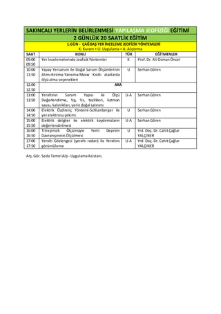
1. SAKINCALI YERLERİN BELİRLENMESİ YAPILAŞMA JEOFİZİĞİ EĞİTİMİ
2 GÜNLÜK 20 SAATLİK EĞİTİM
1.GÜN - ÇAĞDAŞ YER İNCELEME JEOFİZİK YÖNTEMLERİ
K: Kuram + U: Uygulama + A: Alıştırma
SAAT KONU TÜR EĞİTMENLER
09:00
09:50
Yer İncelemelerinde JeofizikYöntemler K Prof.Dr. Ali OsmanÖncel
10:00
11:50
Yapay Yersarsım ile Doğal Sarsım Ölçümlerinin
Alımı-Kırılma-Yansıma-Masw Kısıtlı alanlarda
ölçüalma seçenekleri
U SerhanGören
12.00
12.50
ARA
13:00
13:50
Yeraltının Sarsım Yapısı ile Ölçü
Değerlendirme, Vp, Vs, tezlikleri, katman
sayısı, kalınlıkları,yerindoğal salınımı
U-A SerhanGören
14:00
14:50
Elektrik Özdirenç Yöntemi-Schlumberger ile
yerelektrosuçekimi.
U SerhanGören
15:00
15:50
Elektrik delgiler ile elektrik kaydırmaların
değerlendirilmesi
U-A SerhanGören
16:00
16:50
Titreşimcik Ölçümüyle Yerin Deprem
Davranışınının Ölçülmesi
U Yrd. Doç. Dr. CahitÇağlar
YALÇINER
17:00
17:50
Yeraltı Gözlengeci (yeraltı radarı) ile Yeraltını
görüntüleme
U-A Yrd. Doç. Dr. CahitÇağlar
YALÇINER
Arş.Gör. Seda Temel Alp - UygulamaAsistanı.
2. SAKINCALI YERLERİN BELİRLENMESİ YAPILAŞMA JEOFİZİĞİ EĞİTİMİ
2 GÜNLÜK 20 SAATLİK EĞİTİM
2.GÜN - YER İNCELEME YÖNTEMLERİYLE YER DAYANIM İLE DAVRANIŞINI BELİRLEME-
SAKINCALI YERLERİN ÇABUCAK BELİRLENMESİ
K: Kuram + U: Uygulama + A: Alıştırma
SAAT KONU TÜR EĞİTMENLER
09:00
09:50
Türkiye’nin deprem durumu, deprem ölçümleri, deprem
büyüklüğü,yıkımgücü (şiddeti),depremlerinişleyişleri
K Prof.Dr. Ali Osman
Öncel
10:00-
10:50
Depremin temelde oluşturduğu ivme, yer değiştirme, deprem
sakıncasının bulunması, deprem odağının belirlenmesi.
Depremsakıncasının(risk) belirlenmesi
K+ A Prof.Dr. Ali Osman
Öncel
11:00
11:50
Deprembölgelendirmeyurukları(haritaları),İncelikli
Çalışmaların(microzonation)Kentsel TasarımdaKullanılması.
K Prof.Dr. Ali Osman
Öncel
12:00
12:50
ARA
13:00
13:50
Yerintürü,Z- Toprak ayrımlanması,esnekliği,baskınsalınım
dönemi,temelkayabelirlemesi,sarsıntıbüyütmesi
K SerhanGören
14:00
15:50
Yerin sarsıntı görüngeleri(spektrumları), deprem yönetmeliği
değiştirgenlerinin bulunması, sağlayıp sağlayamamasın
saptanması
K Doç. Dr. Aydın
Büyüksaraç
16:00
16:50
Toprağın Güvenli Taşıma Gücünün, Yatak Katsayısının
JeofiziktenBulunması,JeofizikYapıTemel Tasarımı
K-A Doç. Dr. Aydın
Büyüksaraç
17:00
17:50
Yerinıslaklığı,yeraltısuyuvarlığı, yeraltında düzensizliklerin,
yeraltıboşluklarınınbelirlenmesi.
K Doç. Dr. Aydın
Büyüksaraç
Arş.Gör. Seda Temel Alp - UygulamaAsistanı.