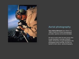
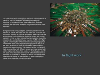
Yann arthus- bertrandEarth from above
Aerial photographyYann Arthus-Bertrand (born March 13, 1946 in Paris) is a French photographer, journalist, reporter and environmentalist.He was an actor when he was young, then he get interested in animals, all about nature. At first time, he get interested in the photography about animals, but then he started to learn about  aerial photography.
CANON EOS-1The perfect camera for the perfect shot from the air is CANON EOS-1.Exceptional image quality is assured with an APS-H size (28.7 x 19.1 mm) CMOS sensor and high performance DIGIC II processor. The EOS-1D Mark II also features 45-point Auto Focus and a start-up time of 0.2 seconds. Its wide 100-1600 ISO speed range is expandable to L:50 and H:3200.
Preparing and assignment and choosing a location  1. If the team’s ambition is to go everywhere, the choice of a particular country must satisfy to various criteria.- Some sites are a prerequisite: Chernobyl, to illustrate a nuclear disaster; or Antarctica, to broach the question of fresh water reserves... Places that are crucial for the messages they convey.- Countries we are invited to, which helps with flying permissions.- Once a country is selected, the team gets in touch with scientists there, buys travel guides, aerial maps, lists local contacts and decides on sites of interest.2. Flying permissions must then be obtained. Highly regulated at the best of time, aerial photography can be prohibited or viewed as spying in some countries.After much negotiating with the relevant authorities (the Army, more often than not), the projected assignment is finalized. These things take time – several months to cover Paris from the air. As to China, the team has been trying to get a green light from the authorities there for the last 4 years...Very often, a military officer will climb aboard the helicopter, and the films will be scrutinized at length before they are returned.3. Finding a plane or flying device is a must. For Europe, the team now has its own helicopter.But some countries have no helicopters or high winged planes to offer, and one or the other must then be brought on location... failing which, one settles for ultra light planes  or paragliders – makes do with whatever is available locally.Now, aerial assignments are often coupled with portrait work or, more recently, with video coverage. This approach allows for better use of time, money, and the team’s energy; it is also more conducive to meeting local populations than aerial photography, remote by its very nature.4. Good weather conditions are, of course, crucial. The greater the distance from the subject matter, the clearer the sky must be, and several days might well be spent waiting for the clouds to lift before the shooting can take place.5. Last but not least, the necessary funds must be found to cover the costs.Using a helicopter for an hour is not cheap, and the search for private or institutional partners who value the team’s work and are willing to finance it is a never-ending process. However, nowadays, the copyright money Yab gets offers the team a certain amount of freedom.
The Earth from above photographs are taken from an altitude of 2000m to 20m – a closeness rendered possible by the helicopter in contrast with past views taken from airplanes.Moreover, the helicopter allows for the greatest precision in the approach.Being able to rely on a good pilot, preferably one familiar with the area, is a must. He is the one who takes you to the site and sometimes points to an unexpected viewing angle; he is the one who positions the photographer above his subject with utmost precision. In this, he plays a crucial part as mediator. Aboard the helicopter, the assistant also has a key role. He fills in the flight logbook containing the GPS coordinates (precise geographical coordinates) of the various places photographed so that, in a few years, scientists or other photographers may come and check on the sites evolution. The assistant is also in charge of the 8 cameras fitted with different lenses, and must rapidly hold out the right one to Yab who is posted by the helicopter door. It’s him again who, dressed in a red jacket, will sometimes end up deposited in the middle of nowhere to restore a human scale in views that can border on the abstract, for aerial photography may at times resemble microphotography.In flight work
Back on the ground, there is still much to be done before the photographs join the library stock. Once the transparencies are safely laid out in plastic sheets, the flight route must be gone over so as to precisely identify each view with by its GPS coordinates, add a detailed place description from the flight log, and localize it on the maps. Then, they are ordered, selected, digitalized and finally archived. To date, this data bank offers some 300,000 views from over a hundred countries.Processing the photos
Writing the captionsPhotos and captions are inseparable. Whether for an exhibition, a school  exercise book or even a puzzle, the team ensures that Earth from above views are never used without the accompanying caption that off sets its meaning.At present, all captions are written and regularly updated by Olivier Milhomme, who is specialized in sustainable development issues. In times of rush (when a book is due out, when an exhibition opens), he is seconded in this task by a team of external scientific writers.Furthermore, in Yab’s books, background articles on sustainable development complement the captions with increased frequency. Written by internationally recognized experts, such texts give the public at large a deeper understanding of the issues at stake, issues that still could do with greater exposure.In France, the team uses a Eurocopter EC-120 Colibri, with a flight autonomy of about 3 hours.When the pilot knows how to fly it with precision, the helicopter is a fabulous tool for aerial photography. It can be flown very low to the ground (certain photographs are taken only at 20 meters from the ground – a distance unthinkable by plane), it can easily be positioned to obtain different frames and it can hover in the same position when the ideal angle is found.Nevertheless, obtaining a helicopter remains a difficult task in many countries our team has visited. Planes with high wings, ULM, parachute  – whatever means necessary, even though more complicated, are used to obtain the photos.

Yann Arthus- Bertrand

  • 1.
  • 2.
    Aerial photographyYann Arthus-Bertrand(born March 13, 1946 in Paris) is a French photographer, journalist, reporter and environmentalist.He was an actor when he was young, then he get interested in animals, all about nature. At first time, he get interested in the photography about animals, but then he started to learn about aerial photography.
  • 3.
    CANON EOS-1The perfectcamera for the perfect shot from the air is CANON EOS-1.Exceptional image quality is assured with an APS-H size (28.7 x 19.1 mm) CMOS sensor and high performance DIGIC II processor. The EOS-1D Mark II also features 45-point Auto Focus and a start-up time of 0.2 seconds. Its wide 100-1600 ISO speed range is expandable to L:50 and H:3200.
  • 4.
    Preparing and assignmentand choosing a location 1. If the team’s ambition is to go everywhere, the choice of a particular country must satisfy to various criteria.- Some sites are a prerequisite: Chernobyl, to illustrate a nuclear disaster; or Antarctica, to broach the question of fresh water reserves... Places that are crucial for the messages they convey.- Countries we are invited to, which helps with flying permissions.- Once a country is selected, the team gets in touch with scientists there, buys travel guides, aerial maps, lists local contacts and decides on sites of interest.2. Flying permissions must then be obtained. Highly regulated at the best of time, aerial photography can be prohibited or viewed as spying in some countries.After much negotiating with the relevant authorities (the Army, more often than not), the projected assignment is finalized. These things take time – several months to cover Paris from the air. As to China, the team has been trying to get a green light from the authorities there for the last 4 years...Very often, a military officer will climb aboard the helicopter, and the films will be scrutinized at length before they are returned.3. Finding a plane or flying device is a must. For Europe, the team now has its own helicopter.But some countries have no helicopters or high winged planes to offer, and one or the other must then be brought on location... failing which, one settles for ultra light planes or paragliders – makes do with whatever is available locally.Now, aerial assignments are often coupled with portrait work or, more recently, with video coverage. This approach allows for better use of time, money, and the team’s energy; it is also more conducive to meeting local populations than aerial photography, remote by its very nature.4. Good weather conditions are, of course, crucial. The greater the distance from the subject matter, the clearer the sky must be, and several days might well be spent waiting for the clouds to lift before the shooting can take place.5. Last but not least, the necessary funds must be found to cover the costs.Using a helicopter for an hour is not cheap, and the search for private or institutional partners who value the team’s work and are willing to finance it is a never-ending process. However, nowadays, the copyright money Yab gets offers the team a certain amount of freedom.
  • 5.
    The Earth fromabove photographs are taken from an altitude of 2000m to 20m – a closeness rendered possible by the helicopter in contrast with past views taken from airplanes.Moreover, the helicopter allows for the greatest precision in the approach.Being able to rely on a good pilot, preferably one familiar with the area, is a must. He is the one who takes you to the site and sometimes points to an unexpected viewing angle; he is the one who positions the photographer above his subject with utmost precision. In this, he plays a crucial part as mediator. Aboard the helicopter, the assistant also has a key role. He fills in the flight logbook containing the GPS coordinates (precise geographical coordinates) of the various places photographed so that, in a few years, scientists or other photographers may come and check on the sites evolution. The assistant is also in charge of the 8 cameras fitted with different lenses, and must rapidly hold out the right one to Yab who is posted by the helicopter door. It’s him again who, dressed in a red jacket, will sometimes end up deposited in the middle of nowhere to restore a human scale in views that can border on the abstract, for aerial photography may at times resemble microphotography.In flight work
  • 6.
    Back on theground, there is still much to be done before the photographs join the library stock. Once the transparencies are safely laid out in plastic sheets, the flight route must be gone over so as to precisely identify each view with by its GPS coordinates, add a detailed place description from the flight log, and localize it on the maps. Then, they are ordered, selected, digitalized and finally archived. To date, this data bank offers some 300,000 views from over a hundred countries.Processing the photos
  • 7.
    Writing the captionsPhotosand captions are inseparable. Whether for an exhibition, a school exercise book or even a puzzle, the team ensures that Earth from above views are never used without the accompanying caption that off sets its meaning.At present, all captions are written and regularly updated by Olivier Milhomme, who is specialized in sustainable development issues. In times of rush (when a book is due out, when an exhibition opens), he is seconded in this task by a team of external scientific writers.Furthermore, in Yab’s books, background articles on sustainable development complement the captions with increased frequency. Written by internationally recognized experts, such texts give the public at large a deeper understanding of the issues at stake, issues that still could do with greater exposure.In France, the team uses a Eurocopter EC-120 Colibri, with a flight autonomy of about 3 hours.When the pilot knows how to fly it with precision, the helicopter is a fabulous tool for aerial photography. It can be flown very low to the ground (certain photographs are taken only at 20 meters from the ground – a distance unthinkable by plane), it can easily be positioned to obtain different frames and it can hover in the same position when the ideal angle is found.Nevertheless, obtaining a helicopter remains a difficult task in many countries our team has visited. Planes with high wings, ULM, parachute – whatever means necessary, even though more complicated, are used to obtain the photos.