Download free for 30 days
Sign in
Upload
Language (EN)
Support
Business
Mobile
Social Media
Marketing
Technology
Art & Photos
Career
Design
Education
Presentations & Public Speaking
Government & Nonprofit
Healthcare
Internet
Law
Leadership & Management
Automotive
Engineering
Software
Recruiting & HR
Retail
Sales
Services
Science
Small Business & Entrepreneurship
Food
Environment
Economy & Finance
Data & Analytics
Investor Relations
Sports
Spiritual
News & Politics
Travel
Self Improvement
Real Estate
Entertainment & Humor
Health & Medicine
Devices & Hardware
Lifestyle
Change Language
Language
English
Español
Português
Français
Deutsche
Cancel
Save
Submit search
EN
Uploaded by
Lisa Schmidt
5,900 views
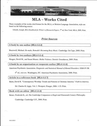
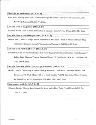
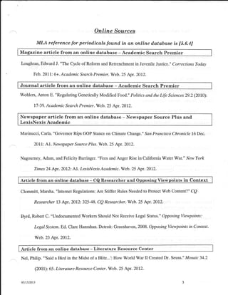
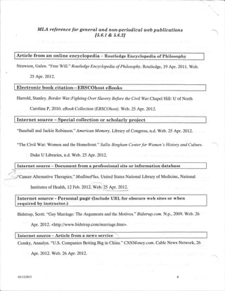
Writing workshop handout
Read more
1
Save
Share
Embed
Embed presentation
Download
Download to read offline
1
/ 4
2
/ 4
3
/ 4
4
/ 4
More Related Content
PDF
Goodsrce
by
lschmidt1170
PDF
Grading matrix presentations
by
lschmidt1170
PPT
Guide to presentations
by
lschmidt1170
PPT
Ch16
by
lschmidt1170
PPT
Ch18
by
lschmidt1170
PDF
Fall 2016 syllabus geog 110 onl
by
lschmidt1170
PPT
Ch19
by
lschmidt1170
PPT
Ch20
by
lschmidt1170
Goodsrce
by
lschmidt1170
Grading matrix presentations
by
lschmidt1170
Guide to presentations
by
lschmidt1170
Ch16
by
lschmidt1170
Ch18
by
lschmidt1170
Fall 2016 syllabus geog 110 onl
by
lschmidt1170
Ch19
by
lschmidt1170
Ch20
by
lschmidt1170
More from Lisa Schmidt
PPT
Chapter 1 A World Of Regions
by
Lisa Schmidt
PDF
Eastern europe
by
Lisa Schmidt
PDF
The giant ancient forest you cannot see coyote crossing
by
Lisa Schmidt
PDF
Summer geog lab 2016 schmidt
by
Lisa Schmidt
PDF
Summer geog 101 2016 schmidt
by
Lisa Schmidt
PDF
Summer 2016 geog 110 schmidt
by
Lisa Schmidt
PDF
Daylight saving time may have health costs la times
by
Lisa Schmidt
PDF
Daylight saving time could end in california the sacramento bee
by
Lisa Schmidt
PDF
Ch 3 worksheet edited
by
Lisa Schmidt
PPT
Intro spring 2016
by
Lisa Schmidt
PPT
Intro spring 2016 geog 101 l
by
Lisa Schmidt
DOC
Syllabus geography 102 spring 2016
by
Lisa Schmidt
PDF
Could a great quake strike on the enigmatic san jacinto fault temblor
by
Lisa Schmidt
PPT
Introspringonlinegeog110 14 wk
by
Lisa Schmidt
PDF
Spring 2016 syllabus geog 110 sect 71
by
Lisa Schmidt
PDF
Spring geog 101 mon 2016 schmid
by
Lisa Schmidt
PDF
Geog lab syllabus wed spring 2016
by
Lisa Schmidt
PDF
Will exxon have to pay for years of misleading the public bill moyers
by
Lisa Schmidt
PDF
Periodic table's 7th row completed with discovery of four new elements ifl ...
by
Lisa Schmidt
PPT
Geography basics
by
Lisa Schmidt
Chapter 1 A World Of Regions
by
Lisa Schmidt
Eastern europe
by
Lisa Schmidt
The giant ancient forest you cannot see coyote crossing
by
Lisa Schmidt
Summer geog lab 2016 schmidt
by
Lisa Schmidt
Summer geog 101 2016 schmidt
by
Lisa Schmidt
Summer 2016 geog 110 schmidt
by
Lisa Schmidt
Daylight saving time may have health costs la times
by
Lisa Schmidt
Daylight saving time could end in california the sacramento bee
by
Lisa Schmidt
Ch 3 worksheet edited
by
Lisa Schmidt
Intro spring 2016
by
Lisa Schmidt
Intro spring 2016 geog 101 l
by
Lisa Schmidt
Syllabus geography 102 spring 2016
by
Lisa Schmidt
Could a great quake strike on the enigmatic san jacinto fault temblor
by
Lisa Schmidt
Introspringonlinegeog110 14 wk
by
Lisa Schmidt
Spring 2016 syllabus geog 110 sect 71
by
Lisa Schmidt
Spring geog 101 mon 2016 schmid
by
Lisa Schmidt
Geog lab syllabus wed spring 2016
by
Lisa Schmidt
Will exxon have to pay for years of misleading the public bill moyers
by
Lisa Schmidt
Periodic table's 7th row completed with discovery of four new elements ifl ...
by
Lisa Schmidt
Geography basics
by
Lisa Schmidt
Download