WEATHER AND SEASONS
•Download as PPTX, PDF•
0 likes•73 views

This power point shows the different seasons in each hemisphere and examplifies the vocabulary using New York City and Brasília as examples.
Report
Share
Report
Share

Recommended
Seasonal change
This document discusses the different seasons in India. It describes the typical weather patterns of summer, winter, autumn, spring, and the rainy season. Summer is the hottest season with May and June being the hottest months. Winter occurs between December and February, when days are shorter and winds are fast and cold. Autumn is mild and occurs between summer and winter, typically starting in September. Spring is the author's favorite season, with longer days and warmer temperatures that are neither too hot nor too cold. The rainy season is between June and September, bringing cool breezes and rain showers.
Bad seasons
The document discusses the causes and characteristics of seasons. It explains that the Earth's tilted axis and yearly orbit around the sun result in seasons, with the northern and southern hemispheres receiving more direct sunlight at different times of year. During summer in each hemisphere, the sun's rays hit the Earth at a steeper angle, increasing sunlight hours and warming temperatures, while winter brings colder conditions due to the sun's shallow angle and shorter days. The piece also outlines the timing and typical weather patterns of spring, summer, autumn and winter.
Season
The document discusses the causes of seasons and factors that determine temperatures in different places. It states that the Earth's axial tilt and yearly revolution around the sun cause the seasons. Several factors influence temperatures, including sunlight duration, the sun's angle above the horizon, and the Earth's distance from the sun. Places near the equator have less temperature variation and defined seasons. Higher latitudes experience more extreme seasonal changes with warm summers and cold winters due to variable sun exposure. Within seasons, temperatures fluctuate based on accumulated heat gains and losses.
THE SEASONS
There are four seasons: winter, spring, summer, and autumn. Winter is the coldest season from December to February in the northern hemisphere and June to August in the southern hemisphere. Spring follows winter with gradually rising temperatures from March to June in the north and September to December in the south. Summer is the warmest season between June to September in the north and December to March in the south. Autumn falls between summer and winter where leaves fall from September to November in the north and March to May in the south.
The Seasons
The document describes the weather patterns associated with each season, with spring bringing rain, summer bringing sun, autumn bringing clouds, and winter bringing cold weather.
The Seasons
Este powerpoint introduce el vocabulario relacionado con las estaciones del año para niños del primer ciclo de primaria.
Powerpoint weather
The document discusses the four seasons of the year - spring, summer, fall, and winter. It lists the months associated with each season and describes common weather patterns, including whether it is sunny, rainy, cloudy, windy, and what temperatures are usually felt during each season.
Seasons
This document provides information about the four seasons: winter, spring, summer, and fall. Each season is described in terms of typical weather patterns, daylight hours, associated months, and common clothing worn during that time of year. Pictures are also included to illustrate characteristics of each season, such as snowy scenes for winter, blooming flowers for spring, beach activities for summer, and changing leaf colors in fall. Students are asked to review the key details about each season, such as winter being the coldest season and summer being the warmest.
Past simple regular and irregular verbs
This document provides information about using the simple past tense in English. It discusses how regular and irregular verbs are conjugated in the past, including examples. It also covers forming negative and yes/no question sentences in the past tense. Key points include:
- The simple past is used for actions that happened at a specific time in the past.
- Regular verbs are conjugated by adding "-ed" to the base form. Irregular verbs have unique past forms.
- To make sentences negative, "didn't" is used with the base form of the verb.
- Yes/no questions are formed with "did" and the subject before the base form of the verb.
STORY - A SCARY NIGHT
This power point is perfect to get your students interested in storytelling! As you read a mystery story with them, they have to guess what happens next, whihc wil provide opportunity for language use. Also, it shows illustrations of key vocabulary and examples with past simple and past continuous. I suggested a creative writing activity in the end.
STORY TELLING
In this power point, you'll find a very easy short story called 'The Catch'. It is an excellent resource to teach beginners how to tell a story using simple vocabulary and structure. You can also use it to review simple past.
STORY TELLING
In this power point, you have a very easy short story called 'The Wrong Number'. It is a great resource to teach beginners how to tell a story using simple vocabulary and structure. You can also use it to review the simple past. If you follow the slides, you'll have the whole class planned.
DESCRIBING CITIES - ADJECTIVES
This power point presents adjectives that are commonly used to describe cities (and their different features). You have an image and an example for each adjective.
DESCRIBING CITIES - SUPERLATIVE
This power point presents quite a long list of adjectives to describe cities. It shows many exmamples and offers an explanation about the use of adjectives in the superlative form, followed by contextualized examples about New York City.
COMPARING CITIES
This document compares several cities across Brazil and the United States. It provides information on the location, attractions, weather, and characteristics of Caldas Novas, Fortaleza, São Paulo, Gramado, and New York. It then prompts the reader to compare these cities on descriptors like exciting, dangerous, crowded, and more. The document also provides instruction on how to form comparative structures in English using adjectives.
LAND USE LAND COVER AND NDVI OF MIRZAPUR DISTRICT, UP
This Dissertation explores the particular circumstances of Mirzapur, a region located in the
core of India. Mirzapur, with its varied terrains and abundant biodiversity, offers an optimal
environment for investigating the changes in vegetation cover dynamics. Our study utilizes
advanced technologies such as GIS (Geographic Information Systems) and Remote sensing to
analyze the transformations that have taken place over the course of a decade.
The complex relationship between human activities and the environment has been the focus
of extensive research and worry. As the global community grapples with swift urbanization,
population expansion, and economic progress, the effects on natural ecosystems are becoming
more evident. A crucial element of this impact is the alteration of vegetation cover, which plays a
significant role in maintaining the ecological equilibrium of our planet.Land serves as the foundation for all human activities and provides the necessary materials for
these activities. As the most crucial natural resource, its utilization by humans results in different
'Land uses,' which are determined by both human activities and the physical characteristics of the
land.
The utilization of land is impacted by human needs and environmental factors. In countries
like India, rapid population growth and the emphasis on extensive resource exploitation can lead
to significant land degradation, adversely affecting the region's land cover.
Therefore, human intervention has significantly influenced land use patterns over many
centuries, evolving its structure over time and space. In the present era, these changes have
accelerated due to factors such as agriculture and urbanization. Information regarding land use and
cover is essential for various planning and management tasks related to the Earth's surface,
providing crucial environmental data for scientific, resource management, policy purposes, and
diverse human activities.
Accurate understanding of land use and cover is imperative for the development planning
of any area. Consequently, a wide range of professionals, including earth system scientists, land
and water managers, and urban planners, are interested in obtaining data on land use and cover
changes, conversion trends, and other related patterns. The spatial dimensions of land use and
cover support policymakers and scientists in making well-informed decisions, as alterations in
these patterns indicate shifts in economic and social conditions. Monitoring such changes with the
help of Advanced technologies like Remote Sensing and Geographic Information Systems is
crucial for coordinated efforts across different administrative levels. Advanced technologies like
Remote Sensing and Geographic Information Systems
9
Changes in vegetation cover refer to variations in the distribution, composition, and overall
structure of plant communities across different temporal and spatial scales. These changes can
occur natural.
Beyond Degrees - Empowering the Workforce in the Context of Skills-First.pptx
Iván Bornacelly, Policy Analyst at the OECD Centre for Skills, OECD, presents at the webinar 'Tackling job market gaps with a skills-first approach' on 12 June 2024
The History of Stoke Newington Street Names
Presented at the Stoke Newington Literary Festival on 9th June 2024
www.StokeNewingtonHistory.com
Leveraging Generative AI to Drive Nonprofit Innovation
In this webinar, participants learned how to utilize Generative AI to streamline operations and elevate member engagement. Amazon Web Service experts provided a customer specific use cases and dived into low/no-code tools that are quick and easy to deploy through Amazon Web Service (AWS.)
Hindi varnamala | hindi alphabet PPT.pdf
हिंदी वर्णमाला पीपीटी, hindi alphabet PPT presentation, hindi varnamala PPT, Hindi Varnamala pdf, हिंदी स्वर, हिंदी व्यंजन, sikhiye hindi varnmala, dr. mulla adam ali, hindi language and literature, hindi alphabet with drawing, hindi alphabet pdf, hindi varnamala for childrens, hindi language, hindi varnamala practice for kids, https://www.drmullaadamali.com
BÀI TẬP DẠY THÊM TIẾNG ANH LỚP 7 CẢ NĂM FRIENDS PLUS SÁCH CHÂN TRỜI SÁNG TẠO ...
BÀI TẬP DẠY THÊM TIẾNG ANH LỚP 7 CẢ NĂM FRIENDS PLUS SÁCH CHÂN TRỜI SÁNG TẠO ...Nguyen Thanh Tu Collection
https://app.box.com/s/qhtvq32h4ybf9t49ku85x0n3xl4jhr15BÀI TẬP BỔ TRỢ TIẾNG ANH LỚP 9 CẢ NĂM - GLOBAL SUCCESS - NĂM HỌC 2024-2025 - ...
BÀI TẬP BỔ TRỢ TIẾNG ANH LỚP 9 CẢ NĂM - GLOBAL SUCCESS - NĂM HỌC 2024-2025 - ...Nguyen Thanh Tu Collection
https://app.box.com/s/tacvl9ekroe9hqupdnjruiypvm9rdaneReimagining Your Library Space: How to Increase the Vibes in Your Library No ...
Librarians are leading the way in creating future-ready citizens – now we need to update our spaces to match. In this session, attendees will get inspiration for transforming their library spaces. You’ll learn how to survey students and patrons, create a focus group, and use design thinking to brainstorm ideas for your space. We’ll discuss budget friendly ways to change your space as well as how to find funding. No matter where you’re at, you’ll find ideas for reimagining your space in this session.
South African Journal of Science: Writing with integrity workshop (2024)
South African Journal of Science: Writing with integrity workshop (2024)Academy of Science of South Africa
A workshop hosted by the South African Journal of Science aimed at postgraduate students and early career researchers with little or no experience in writing and publishing journal articles.Traditional Musical Instruments of Arunachal Pradesh and Uttar Pradesh - RAYH...
Traditional Musical Instruments of Arunachal Pradesh and Uttar Pradesh
What is Digital Literacy? A guest blog from Andy McLaughlin, University of Ab...
What is Digital Literacy? A guest blog from Andy McLaughlin, University of Aberdeen
More Related Content
More from DANIELA DA SILVA ISMAIL
Past simple regular and irregular verbs
This document provides information about using the simple past tense in English. It discusses how regular and irregular verbs are conjugated in the past, including examples. It also covers forming negative and yes/no question sentences in the past tense. Key points include:
- The simple past is used for actions that happened at a specific time in the past.
- Regular verbs are conjugated by adding "-ed" to the base form. Irregular verbs have unique past forms.
- To make sentences negative, "didn't" is used with the base form of the verb.
- Yes/no questions are formed with "did" and the subject before the base form of the verb.
STORY - A SCARY NIGHT
This power point is perfect to get your students interested in storytelling! As you read a mystery story with them, they have to guess what happens next, whihc wil provide opportunity for language use. Also, it shows illustrations of key vocabulary and examples with past simple and past continuous. I suggested a creative writing activity in the end.
STORY TELLING
In this power point, you'll find a very easy short story called 'The Catch'. It is an excellent resource to teach beginners how to tell a story using simple vocabulary and structure. You can also use it to review simple past.
STORY TELLING
In this power point, you have a very easy short story called 'The Wrong Number'. It is a great resource to teach beginners how to tell a story using simple vocabulary and structure. You can also use it to review the simple past. If you follow the slides, you'll have the whole class planned.
DESCRIBING CITIES - ADJECTIVES
This power point presents adjectives that are commonly used to describe cities (and their different features). You have an image and an example for each adjective.
DESCRIBING CITIES - SUPERLATIVE
This power point presents quite a long list of adjectives to describe cities. It shows many exmamples and offers an explanation about the use of adjectives in the superlative form, followed by contextualized examples about New York City.
COMPARING CITIES
This document compares several cities across Brazil and the United States. It provides information on the location, attractions, weather, and characteristics of Caldas Novas, Fortaleza, São Paulo, Gramado, and New York. It then prompts the reader to compare these cities on descriptors like exciting, dangerous, crowded, and more. The document also provides instruction on how to form comparative structures in English using adjectives.
More from DANIELA DA SILVA ISMAIL (7)
Recently uploaded
LAND USE LAND COVER AND NDVI OF MIRZAPUR DISTRICT, UP
This Dissertation explores the particular circumstances of Mirzapur, a region located in the
core of India. Mirzapur, with its varied terrains and abundant biodiversity, offers an optimal
environment for investigating the changes in vegetation cover dynamics. Our study utilizes
advanced technologies such as GIS (Geographic Information Systems) and Remote sensing to
analyze the transformations that have taken place over the course of a decade.
The complex relationship between human activities and the environment has been the focus
of extensive research and worry. As the global community grapples with swift urbanization,
population expansion, and economic progress, the effects on natural ecosystems are becoming
more evident. A crucial element of this impact is the alteration of vegetation cover, which plays a
significant role in maintaining the ecological equilibrium of our planet.Land serves as the foundation for all human activities and provides the necessary materials for
these activities. As the most crucial natural resource, its utilization by humans results in different
'Land uses,' which are determined by both human activities and the physical characteristics of the
land.
The utilization of land is impacted by human needs and environmental factors. In countries
like India, rapid population growth and the emphasis on extensive resource exploitation can lead
to significant land degradation, adversely affecting the region's land cover.
Therefore, human intervention has significantly influenced land use patterns over many
centuries, evolving its structure over time and space. In the present era, these changes have
accelerated due to factors such as agriculture and urbanization. Information regarding land use and
cover is essential for various planning and management tasks related to the Earth's surface,
providing crucial environmental data for scientific, resource management, policy purposes, and
diverse human activities.
Accurate understanding of land use and cover is imperative for the development planning
of any area. Consequently, a wide range of professionals, including earth system scientists, land
and water managers, and urban planners, are interested in obtaining data on land use and cover
changes, conversion trends, and other related patterns. The spatial dimensions of land use and
cover support policymakers and scientists in making well-informed decisions, as alterations in
these patterns indicate shifts in economic and social conditions. Monitoring such changes with the
help of Advanced technologies like Remote Sensing and Geographic Information Systems is
crucial for coordinated efforts across different administrative levels. Advanced technologies like
Remote Sensing and Geographic Information Systems
9
Changes in vegetation cover refer to variations in the distribution, composition, and overall
structure of plant communities across different temporal and spatial scales. These changes can
occur natural.
Beyond Degrees - Empowering the Workforce in the Context of Skills-First.pptx
Iván Bornacelly, Policy Analyst at the OECD Centre for Skills, OECD, presents at the webinar 'Tackling job market gaps with a skills-first approach' on 12 June 2024
The History of Stoke Newington Street Names
Presented at the Stoke Newington Literary Festival on 9th June 2024
www.StokeNewingtonHistory.com
Leveraging Generative AI to Drive Nonprofit Innovation
In this webinar, participants learned how to utilize Generative AI to streamline operations and elevate member engagement. Amazon Web Service experts provided a customer specific use cases and dived into low/no-code tools that are quick and easy to deploy through Amazon Web Service (AWS.)
Hindi varnamala | hindi alphabet PPT.pdf
हिंदी वर्णमाला पीपीटी, hindi alphabet PPT presentation, hindi varnamala PPT, Hindi Varnamala pdf, हिंदी स्वर, हिंदी व्यंजन, sikhiye hindi varnmala, dr. mulla adam ali, hindi language and literature, hindi alphabet with drawing, hindi alphabet pdf, hindi varnamala for childrens, hindi language, hindi varnamala practice for kids, https://www.drmullaadamali.com
BÀI TẬP DẠY THÊM TIẾNG ANH LỚP 7 CẢ NĂM FRIENDS PLUS SÁCH CHÂN TRỜI SÁNG TẠO ...
BÀI TẬP DẠY THÊM TIẾNG ANH LỚP 7 CẢ NĂM FRIENDS PLUS SÁCH CHÂN TRỜI SÁNG TẠO ...Nguyen Thanh Tu Collection
https://app.box.com/s/qhtvq32h4ybf9t49ku85x0n3xl4jhr15BÀI TẬP BỔ TRỢ TIẾNG ANH LỚP 9 CẢ NĂM - GLOBAL SUCCESS - NĂM HỌC 2024-2025 - ...
BÀI TẬP BỔ TRỢ TIẾNG ANH LỚP 9 CẢ NĂM - GLOBAL SUCCESS - NĂM HỌC 2024-2025 - ...Nguyen Thanh Tu Collection
https://app.box.com/s/tacvl9ekroe9hqupdnjruiypvm9rdaneReimagining Your Library Space: How to Increase the Vibes in Your Library No ...
Librarians are leading the way in creating future-ready citizens – now we need to update our spaces to match. In this session, attendees will get inspiration for transforming their library spaces. You’ll learn how to survey students and patrons, create a focus group, and use design thinking to brainstorm ideas for your space. We’ll discuss budget friendly ways to change your space as well as how to find funding. No matter where you’re at, you’ll find ideas for reimagining your space in this session.
South African Journal of Science: Writing with integrity workshop (2024)
South African Journal of Science: Writing with integrity workshop (2024)Academy of Science of South Africa
A workshop hosted by the South African Journal of Science aimed at postgraduate students and early career researchers with little or no experience in writing and publishing journal articles.Traditional Musical Instruments of Arunachal Pradesh and Uttar Pradesh - RAYH...
Traditional Musical Instruments of Arunachal Pradesh and Uttar Pradesh
What is Digital Literacy? A guest blog from Andy McLaughlin, University of Ab...
What is Digital Literacy? A guest blog from Andy McLaughlin, University of Aberdeen
How to Setup Warehouse & Location in Odoo 17 Inventory
In this slide, we'll explore how to set up warehouses and locations in Odoo 17 Inventory. This will help us manage our stock effectively, track inventory levels, and streamline warehouse operations.
Advanced Java[Extra Concepts, Not Difficult].docx
This is part 2 of my Java Learning Journey. This contains Hashing, ArrayList, LinkedList, Date and Time Classes, Calendar Class and more.
Pollock and Snow "DEIA in the Scholarly Landscape, Session One: Setting Expec...
Pollock and Snow "DEIA in the Scholarly Landscape, Session One: Setting Expec...National Information Standards Organization (NISO)
This presentation was provided by Steph Pollock of The American Psychological Association’s Journals Program, and Damita Snow, of The American Society of Civil Engineers (ASCE), for the initial session of NISO's 2024 Training Series "DEIA in the Scholarly Landscape." Session One: 'Setting Expectations: a DEIA Primer,' was held June 6, 2024.clinical examination of hip joint (1).pdf
described clinical examination all orthopeadic conditions .
Walmart Business+ and Spark Good for Nonprofits.pdf
"Learn about all the ways Walmart supports nonprofit organizations.
You will hear from Liz Willett, the Head of Nonprofits, and hear about what Walmart is doing to help nonprofits, including Walmart Business and Spark Good. Walmart Business+ is a new offer for nonprofits that offers discounts and also streamlines nonprofits order and expense tracking, saving time and money.
The webinar may also give some examples on how nonprofits can best leverage Walmart Business+.
The event will cover the following::
Walmart Business + (https://business.walmart.com/plus) is a new shopping experience for nonprofits, schools, and local business customers that connects an exclusive online shopping experience to stores. Benefits include free delivery and shipping, a 'Spend Analytics” feature, special discounts, deals and tax-exempt shopping.
Special TechSoup offer for a free 180 days membership, and up to $150 in discounts on eligible orders.
Spark Good (walmart.com/sparkgood) is a charitable platform that enables nonprofits to receive donations directly from customers and associates.
Answers about how you can do more with Walmart!"
Recently uploaded (20)
LAND USE LAND COVER AND NDVI OF MIRZAPUR DISTRICT, UP
LAND USE LAND COVER AND NDVI OF MIRZAPUR DISTRICT, UP
Beyond Degrees - Empowering the Workforce in the Context of Skills-First.pptx
Beyond Degrees - Empowering the Workforce in the Context of Skills-First.pptx
Leveraging Generative AI to Drive Nonprofit Innovation
Leveraging Generative AI to Drive Nonprofit Innovation
Digital Artefact 1 - Tiny Home Environmental Design
Digital Artefact 1 - Tiny Home Environmental Design
BÀI TẬP DẠY THÊM TIẾNG ANH LỚP 7 CẢ NĂM FRIENDS PLUS SÁCH CHÂN TRỜI SÁNG TẠO ...
BÀI TẬP DẠY THÊM TIẾNG ANH LỚP 7 CẢ NĂM FRIENDS PLUS SÁCH CHÂN TRỜI SÁNG TẠO ...
BÀI TẬP BỔ TRỢ TIẾNG ANH LỚP 9 CẢ NĂM - GLOBAL SUCCESS - NĂM HỌC 2024-2025 - ...
BÀI TẬP BỔ TRỢ TIẾNG ANH LỚP 9 CẢ NĂM - GLOBAL SUCCESS - NĂM HỌC 2024-2025 - ...
Reimagining Your Library Space: How to Increase the Vibes in Your Library No ...
Reimagining Your Library Space: How to Increase the Vibes in Your Library No ...
South African Journal of Science: Writing with integrity workshop (2024)
South African Journal of Science: Writing with integrity workshop (2024)
Traditional Musical Instruments of Arunachal Pradesh and Uttar Pradesh - RAYH...
Traditional Musical Instruments of Arunachal Pradesh and Uttar Pradesh - RAYH...
What is Digital Literacy? A guest blog from Andy McLaughlin, University of Ab...
What is Digital Literacy? A guest blog from Andy McLaughlin, University of Ab...
How to Setup Warehouse & Location in Odoo 17 Inventory
How to Setup Warehouse & Location in Odoo 17 Inventory
Pollock and Snow "DEIA in the Scholarly Landscape, Session One: Setting Expec...
Pollock and Snow "DEIA in the Scholarly Landscape, Session One: Setting Expec...
Walmart Business+ and Spark Good for Nonprofits.pdf
Walmart Business+ and Spark Good for Nonprofits.pdf
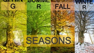
WEATHER AND SEASONS
- 2. Seasons happen in different times of the year in each hemisphere
- 3. SUMME R WINTER FALL SPRING WINTER SUMME R FALL SPRING Dec. 21st – Mar.21st Mar. 21st – Jun. 21st Jun. 21st – Sep. 23rd Sep. 23rd – Dec. 21st
- 5. WINTE cold snowy windy Dec. 21st – Mar.21st
- 6. SUMMER warm humid Dec. 21st – Mar.21st rainy
- 7. SPRING warm humid Mar. 21st – Jun. 21st
- 8. AUTUMN / FALL cool dry Mar. 21st – Jun. 21st
- 9. SUMMER hot sunny Jun. 21st – Sep. 23rd
- 10. WINTE R cold dry Jun. 21st – Sep. 23rd
- 11. AUTUMN / FALL cool cold Sep. 23rd – Dec. 21st
- 12. SPRING hot humid Sep. 23rd – Dec. 21st