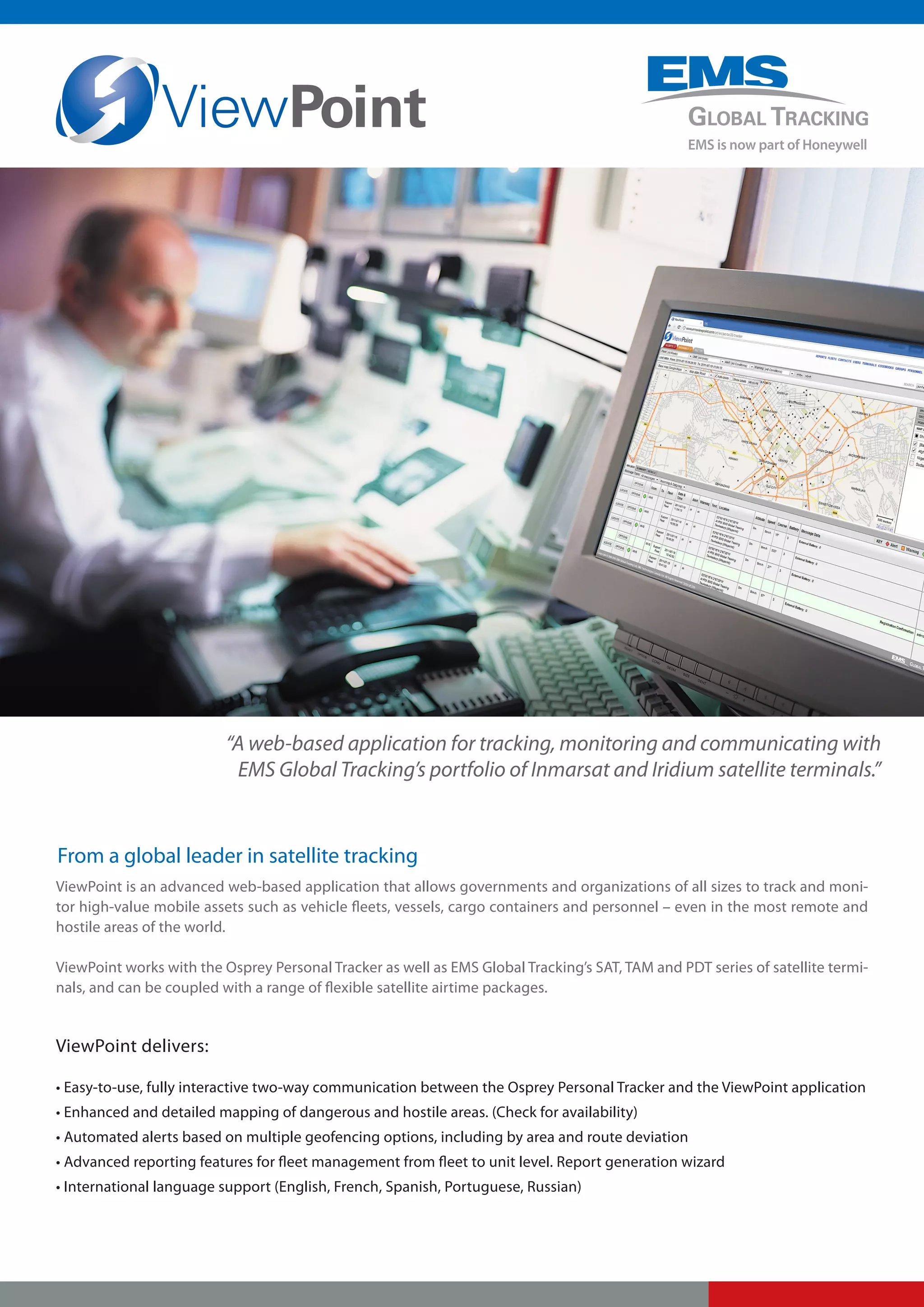
“A web-based application for tracking, monitoring and communicating with
                           EMS Global Tracking’s portfolio of Inmarsat and Iridium satellite terminals.”


From a global leader in satellite tracking
ViewPoint is an advanced web-based application that allows governments and organizations of all sizes to track and moni-
tor high-value mobile assets such as vehicle fleets, vessels, cargo containers and personnel – even in the most remote and
hostile areas of the world.

ViewPoint works with the Osprey Personal Tracker as well as EMS Global Tracking’s SAT, TAM and PDT series of satellite termi-
nals, and can be coupled with a range of flexible satellite airtime packages.


ViewPoint delivers:

• Easy-to-use, fully interactive two-way communication between the Osprey Personal Tracker and the ViewPoint application
• Enhanced and detailed mapping of dangerous and hostile areas. (Check for availability)
• Automated alerts based on multiple geofencing options, including by area and route deviation
• Advanced reporting features for fleet management from fleet to unit level. Report generation wizard
• International language support (English, French, Spanish, Portuguese, Russian)
Terminal         ViewPoint               Airtime


                 One unified solution from EMS Global Tracking


ViewPoint Key Features and Functionality
Communications                                                        Multiple Geofence options
• Worldwide web-based tracking, messaging and alerting                • Warning – warning raised if a unit travels inside a warning area
• Alert notification to multiple contacts via SMS and email           • Alert – alert raised if a unit travels inside an alert area
• Terminal-to-terminals messaging(*)                                  • Safe – warning raised if a unit travels outside all safe areas
• Send text messages and configuration messages to                    • Route – alert or warn if message raised if a unit travels outside defined
  selected groups of terminals(*)                                     . route corridor
• Up to 450 customizable, pre-defined messages(*)                     • Curfew – apply specific curfew times to any warning or alert geofence
• User can create a personal address book(*)                          • Waypoint – notification when a unit enters and departs a geofence
• Synchronization “over-the-air” of pre-defined messages              • Checkpoint – notification raised if a unit is late arriving at a waypoint
 and address book(*)                                                  . (applied on a per-unit basis)
*device dependant                                                     • Overdue warning – unit has stopped transmitting
                                                                      • Static warning – unit is still reporting, but has stopped moving
Mapping
                                                                      Fleet Management
• Highly interactive and extendable mapping
                                                                      • Locate by alert status, fleet name, group or user-defined attributes or
• Spatially indexed GIS database for rapid location of
                                                                        terminal name
  terminals or Point of Interest (POI) on the map
                                                                      • Request current location for any terminal in the fleet
• Google and Bing base layer maps
                                                                      • Remote updating of GPS reporting intervals
• Detailed mapping of remote and potentially dangerous
  or hostile areas                                                    • Quickly locate and allow you to connect with the nearest Personal
                                                                        Tracker in your group or fleet
• Operator selectable detail map layers (in addition to base
  layer maps)                                                         • Advanced report generation wizard for:
• Define and precisely locate your own POI’s                              • Individual units, units matching user-defined criteria or whole
                                                                             fleet
• Customize map views using POI’s
                                                                          • Schedule or on-demand reports
• View: current position, recent events and tracking history
                                                                          • CSV, PDF and HTML format
• Point-to-point distance and route length measurement tool               • Idling, speeding, mileage, time in geofence, summary
                                                                             information


                                                                                                                      Subject to change without notice

Miller Court, Severn Drive                          4503 W. DeYoung St                                     Av. Bernardino de Campos 98
Tewkesbury Business Park                            Suite 204C                                             Paraiso
Tewkesbury, Gloucestershire                         Marion, Il 62959                                       San Paulo
GL20 8DN, UK                                        USA                                                    04004-040, Brazil
+44 (0) 1684 278610                                 +1 301 560 4716                                        +55 11 3886 4800
info@emsglobaltracking.com                          sales.na@emsglobaltracking.com                         sales.la@emsglobaltracking.com


400 Maple Grove Road                                Dubai Internet City
Ottawa, Ontario                                     Building 2, Office 103
K2V 1B8, Canada                                     PO Box 500122
+1 800 600 9759 (N. America)                        Dubai, UAE
+1 613 591 6040 (Worldwide)                         +971 4 3654918
empsales@emsglobaltracking.com                      sales.me@emsglobaltracking.com

Published August, 2011                                                                                               www.emsglobaltracking.com

ViewPoint Mapping Application

  • 1.
    “A web-based applicationfor tracking, monitoring and communicating with EMS Global Tracking’s portfolio of Inmarsat and Iridium satellite terminals.” From a global leader in satellite tracking ViewPoint is an advanced web-based application that allows governments and organizations of all sizes to track and moni- tor high-value mobile assets such as vehicle fleets, vessels, cargo containers and personnel – even in the most remote and hostile areas of the world. ViewPoint works with the Osprey Personal Tracker as well as EMS Global Tracking’s SAT, TAM and PDT series of satellite termi- nals, and can be coupled with a range of flexible satellite airtime packages. ViewPoint delivers: • Easy-to-use, fully interactive two-way communication between the Osprey Personal Tracker and the ViewPoint application • Enhanced and detailed mapping of dangerous and hostile areas. (Check for availability) • Automated alerts based on multiple geofencing options, including by area and route deviation • Advanced reporting features for fleet management from fleet to unit level. Report generation wizard • International language support (English, French, Spanish, Portuguese, Russian)
  • 2.
    Terminal ViewPoint Airtime One unified solution from EMS Global Tracking ViewPoint Key Features and Functionality Communications Multiple Geofence options • Worldwide web-based tracking, messaging and alerting • Warning – warning raised if a unit travels inside a warning area • Alert notification to multiple contacts via SMS and email • Alert – alert raised if a unit travels inside an alert area • Terminal-to-terminals messaging(*) • Safe – warning raised if a unit travels outside all safe areas • Send text messages and configuration messages to • Route – alert or warn if message raised if a unit travels outside defined selected groups of terminals(*) . route corridor • Up to 450 customizable, pre-defined messages(*) • Curfew – apply specific curfew times to any warning or alert geofence • User can create a personal address book(*) • Waypoint – notification when a unit enters and departs a geofence • Synchronization “over-the-air” of pre-defined messages • Checkpoint – notification raised if a unit is late arriving at a waypoint and address book(*) . (applied on a per-unit basis) *device dependant • Overdue warning – unit has stopped transmitting • Static warning – unit is still reporting, but has stopped moving Mapping Fleet Management • Highly interactive and extendable mapping • Locate by alert status, fleet name, group or user-defined attributes or • Spatially indexed GIS database for rapid location of terminal name terminals or Point of Interest (POI) on the map • Request current location for any terminal in the fleet • Google and Bing base layer maps • Remote updating of GPS reporting intervals • Detailed mapping of remote and potentially dangerous or hostile areas • Quickly locate and allow you to connect with the nearest Personal Tracker in your group or fleet • Operator selectable detail map layers (in addition to base layer maps) • Advanced report generation wizard for: • Define and precisely locate your own POI’s • Individual units, units matching user-defined criteria or whole fleet • Customize map views using POI’s • Schedule or on-demand reports • View: current position, recent events and tracking history • CSV, PDF and HTML format • Point-to-point distance and route length measurement tool • Idling, speeding, mileage, time in geofence, summary information Subject to change without notice Miller Court, Severn Drive 4503 W. DeYoung St Av. Bernardino de Campos 98 Tewkesbury Business Park Suite 204C Paraiso Tewkesbury, Gloucestershire Marion, Il 62959 San Paulo GL20 8DN, UK USA 04004-040, Brazil +44 (0) 1684 278610 +1 301 560 4716 +55 11 3886 4800 info@emsglobaltracking.com sales.na@emsglobaltracking.com sales.la@emsglobaltracking.com 400 Maple Grove Road Dubai Internet City Ottawa, Ontario Building 2, Office 103 K2V 1B8, Canada PO Box 500122 +1 800 600 9759 (N. America) Dubai, UAE +1 613 591 6040 (Worldwide) +971 4 3654918 empsales@emsglobaltracking.com sales.me@emsglobaltracking.com Published August, 2011 www.emsglobaltracking.com