Total Place Maps for Education, Planning, Assets & Economic Development
•Download as PPT, PDF•
0 likes•149 views

This document outlines several uses for total place maps including showing education data and school locations, displaying local development plans and designated areas, managing public land and property assets, and aiding economic development by showing businesses, development sites, and socio-economic indicators in relation to transportation infrastructure. The maps are meant to underpin local frameworks and display various locations and supporting information for communities, schools, land/property and economic development.

Recommended
More Related Content
Viewers also liked
Viewers also liked (20)
More from LFG
More from LFG (20)
Recently uploaded
Recently uploaded (20)
Total Place Maps for Education, Planning, Assets & Economic Development
- 3. Show base maps
- 5. Show schools and supporting information
- 7. Show other buildings and supporting information
- 8. Show priority areas and zones
- 10. Show land/sites
- 11. Show Green Belt and other designated areas
- 13. Show all property and sites
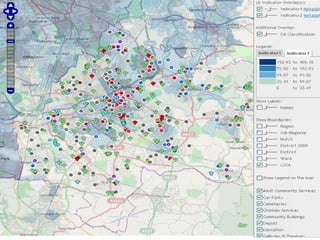
- 14. Show Socio- economic indicators
- 15. Show geo- demographic classifications
- 16. Shows Adult Community Services