
Recommended
More Related Content
Similar to The new WAC eTool embedding One Tool Power for SiteSync Pro
Similar to The new WAC eTool embedding One Tool Power for SiteSync Pro (20)
Recently uploaded
Recently uploaded (20)
The new WAC eTool embedding One Tool Power for SiteSync Pro
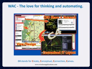
- 1. WAC - The love for thinking and automating. www.wirelessapplications.com C4 stands for Create, Conceptual, Connection, Canvas.
- 2. For users, the goal is for them to CREATE by either uploading their data from spreadsheet form into the C4 Canvas platform or manually create their network design on the fly. Second, users will begin to CONCEPTUALIZE their network by asking questions, creating scenarios, analyzing possible disruptions in their network, and ponder if/then scenarios that could affect the overall performance of their network. The next step is to build the CONNECTION. The user begins to create logical connections between points with the goal of building the highest performing network on the market. These decisions stem from the microwave backhaul design information given beforehand from researched interference areas, proximity to buildings, and other variables that could affect the performance. The last "C" is Canvas. Just as an artist would, the user uses this platform to take what comes from a geodesic engineering world and modify it to be that of a IT network world. C4 allows for complete moving / morphing of sites to a more network tracking scenario layout while still being tied directly to the incoming engineering data. C4 is intended to be the most user-friendly software tool on the market for top-down officers, managers, IT and into the microwave design engineers and site acquisition specialists to create, organize, and share what they need for their projects. Stay up to date with project status. The goal is for the user to be able to do a variety of processes inside of the C4 tool: Our C4 Canvas in SiteSync Pro • Visualize microwave backhaul, number of channels in a whole new way, WAC Drapes. • Add ins for a cosmetic overlay for displaying other sites, paths, routes not directly related to engineering outputs. • Communicate, yet regulate via privacy settings, the network to internal/external management, customers, employees, and contractors. •Simple Microwave Path clearance checks at any time for Point to Point analysis of All paths, clear or even the Failed ones. • Able to sync imported spreadsheet data 'after the fact' for Monitoring the site acquisition "maturity" of your network. • See any design paths of specified network groups of View Save Paths area of SSPro. • Search filter area for paths based on multiple categories, such as status, freq, data-rates, colors, etc to view what you want to see in an instant. • Update site or path information manually or automatically through easy edits for relaying status either to or from site acquisition and construction.
- 3. WAC - The love for thinking and automating. www.wirelessapplications.com Search: Towers, Microwave networks, Demographics, Spectrum
- 4. Nationwide Searching in SiteSync Pro The SiteSync Pro Search features has never been so dynamic! With one spot on the map you are able to learn about demographics at a given area, business and highway traffic counts, structures, microwave paths and with our latest Add-ins, nationwide Parcel data queried from CoreLogic,and Fiber Routes from GeoTel Communications - all from the same web-based tool! Wireless Applications' Structures component allows users to simply pick a spot on the map, select a radius and instantaneously obtain a comprehensive site summary and map detailing a complete list of structures from our million record database. For wireless professionals planning a network, being able to quickly obtain detailed information on a given location makes for a more educational decision when it comes to building a network. Get in - Get out, or Get in and Stay in! The Wireless Applications' Structures component allows users the ability to not only research their own site and networks but their competitors as well. Microwave networks have exploded from roughly 25,000 filings back in 2006 to over 110,000 last year! With our Search Filed Microwave, users can query paths by frequency, areas, owners or call-sign and visualize the real paths down to their Path Profiles, ownership details or even pushed them to our Microwave Design area!
- 5. WAC - The love for thinking and automating. www.wirelessapplications.com Add-ins Integrated: Nationwide Parcels, Nationwide Fiber
- 6. Our Add-ins for SiteSync Pro Our SiteSync Pro tool offers some of the most detailed and informative datasets. Both the CoreLogic Parcels and GeoTel Fiber Route layers add a great overlay for your map! With CoreLogic Parcels, you are able to learn all about the land ownership and land use information for a given area. GeoTel Fiber Routes allows you to research Fiber or Lit Buildings in and around your wireless network. Both together with your structure information, the user and audience have the ability to see the entire network around them and be empowered to make informative choices to insure a great performing network. CoreLogic Parcels and GeoTel Fiber data layers offer the user the visual representation on the map as well as easy to understand data reports to help support the network the user is designing. Never will you have to seek outside third party data to make your network better, we've put it all in one tool! SiteSync Pro offers an "Extras" map menu which includes a number of FCC boundary and other telecom overlays and now both CoreLogic Parcels and GeoTel Fiber join the list. Together the two "Add-Ins" make for a great compliment to your structures and microwave research. Not only can you research where your ownership is and that of your competitors for items such as structures, but you can now see who owns the land in those areas and where the fiber routes are just by toggling the layers on! Data made easy, its Dirt Simple ! Wireless Applications offers "Add-Ins" that work within the SiteSync Pro platform and TNT2 MW Enterprise toolset. The two currently available to our users, are the CoreLogic parcel data layer, and the other the nationwide dataset form GeoTel for Fiber Routes and Lit Buildings! Network engineers, Planners, PMs, Business Developers and others can use this in-depth information to build their systems. Growing your network has just gotten smarter with knowing more about your site before stepping foot on it!
- 7. WAC - The love for thinking and automating. www.wirelessapplications.com eMwave : Microwave Backhaul, Research, Design, Regulatory
- 8. eMwave for Microwave in SiteSync Pro Microwave Engineers and their colleagues often want to see the "big picture" when it comes to their network. Not a problem. With eMwave, you can research the location of your microwave paths you design, discover whether a microwave path can be achieved between two points, and ask the question of whether their path will be interrupted by trees or terrain. These variables are often the key players that indicate whether your microwave network is going to high performing network or not. eMwave is a complex component within SiteSync Pro that gives amazing results. Search your filed microwave paths with specific criteria, and from there you can research line of sight and interference to find your high performing paths. You can save your results to a portfolio and generate a C4 canvas as well. Microwave engineers can go from a search to site acquisition mode and monitor the site and path statuses with the goal of reaching network maturity. How does your microwave network compare to your competitors with regards to path count, frequency, and geographic location? With eMwave you can research these questions easily! Just by searching owner name you can quickly compare how your network competes with other companies within your geographic location and beyond!
- 9. WAC - The love for thinking and automating. www.wirelessapplications.com eCoverage : Full Downlink, RF Contour, TV Contour
- 10. Propagation Modeling in SiteSync Pro eCoverage is Wireless Applications' propagation component that renders prediction coverage on the fly after selecting a structure from our large database, or from simply dropping a pin on the map. Within seconds, your input criteria is used to produce what coverage is to be expected at a given location. Our eCoverage tool is simplified to basic RF needs, both engineers and non-engineers no longer have to waste countless minutes inputting data just to get a coverage plot. In the background, our Best Fit modeling wrapped around Longley-Rice algorithms, rendering thousands of calculations over terrain to get a view of a coverage in multicolor thresholds. Needing to perform coverage analysis at a proposed site location? Wondering how much coverage area is created from a single site? What to change with regards to heights or power? With eCoverage, you can input a minimal set of requirements and with one click, your propagation will appear. eCoverage uses worldwide, various high resolution terrain data accompanied with enhanced Longley-Rice methods to create detailed RF propagation in little to no time! This tool enables the user to qualify their location and add operating efficiency to any network they create! With eCoverage, site acquisition, business development, construction or other professionals can easily run and analyze the RF propagation to determine the viability of a location and its coverage. Are you an engineer in the need of sharing your RF Propagation findings to a colleague or executive? Trying to determine if your proposed site is the optimal spot for construction of a new site based on coverage? With eCoverage, you can quickly and efficiently find that answer!
- 11. WAC – Introducing the NEW WAC eTool ! Sample slide show of use for getting to know our WAC e Power
- 12. WAC – Introducing the NEW WAC eTool ! Sample slide show of use for getting to know our WAC e Power
- 50. www.wirelessapplications.com Thank you from 47.610590, -122.196593 111 108th Ave. NE., Suite A160 Bellevue, WA 98004 Phone: (425)-643-5000 Fax: (425)-649-5675 Email: info@wacorp.net Website: www.wirelessapplications.com