PARTICIPATORY APPROACHES
Stakeholder managementand Participation in urban governance.
• Who are the stakeholders? (Citizens, government agencies, NGOs, private sector, informal
sector, etc.)
• Why is stakeholder participation critical in urban projects?
• Challenges of stakeholder participation in urban contexts (e.g., complexity, power asymmetry,
urban-rural divide).
2.
PARTICIPATORY APPROACHES
• Themain challenge the development practitioners face…
• Participation: meaning
• Why participation???
• Types of participation???
• From Information sharing---consultation---Collaboration---Empowerment---
• Limitation of Participation…
3.
PARTICIPATORY APPROACHES: Doesit hold the key to development
• How should one go about the task of enabling the people to participate in the process of
shaping their own destiny without expecting outside support and assistance?
• Is this really a practicable and sensible proposition after all?
• Do the ordinary people have the capability and knowledge required to analyse situations and
conditions, and take development initiatives upon themselves?
ANSWER=PRA/PUA/PLA
4.
PARTICIPATORY APPROACHES: Doesit hold the key to development
• Origins of Participatory Methods: RRA and PRA
• Survey and Rural Development Tourism
• Work of Robert Chambers
5.
RAPID RURAL APPRAISAL
•RRA is a way of organising people for collecting and analysing information
within a short time span.
• It is defined as ‘any systematic process of investigation to acquire new
information in order to draw and validate inferences, hypothesis, observation
and conclusions in a limited period of time’ (N. Mukherjee 1994b).
• It has the flexibility of adjusting to situations because it does not imply or
recommend a standard set of methods to be applied in each case.
• The methods vary from situation to situation and are determined by local
conditions, local problems and objectives at hand.
6.
RAPID RURAL APPRAISALTO PARTICIPATORY RURAAL APPRAISAL
• It was extractive in nature.
• The team that gathered the data and the information from outside owned the
information. They did not share this information with the people.
• Appraisal was the core activity of RRA. After the appraisal, the team from
outside failed to make the people the focus of the issue.
• This method emphasised more on methods and outputs rather than on the
attitude and behaviour of the outsiders.
• It had little aspiration to empower poor people or to generate self-help
community development initiatives
7.
PARTICIPATORY RURAL APPRAISAL
•‘A semi-structured activity carried out in the field, by a multi-disciplinary team and designed
to quickly acquire new information on, and new hypothesis about rural life’.
• Some of the important features that emerge from this definition are:
(i) it is a field-based appraisal undertaken by a multi-disciplinary team;
(ii) it is quick;
(iii) it is mostly an information-gathering technique and
(iv) it is exploratory in nature
8.
PARTICIPATORY RURAL APPRAISAL
•PRA is predominantly a participatory process. It provides a vast scope and space for both people as well as
outsiders to actively participate at every stage of the PRA process
• A preset questionnaire is not used in PRA; rather a semi-structured interview technique is followed. This
provides a lot of opportunities for the outsiders to explore and learn progressively.
• PRA is an interactive process. The ideas of outsiders and people interact and thus facilitate in mutual learning.
• PRA is enabling in nature. It enables the people to learn about their condition and situation. The PRA process
also seeks to enable outsiders to learn; but through the sharing of information in a manner which enhances the
analysis and knowledge of the people.
• PRA believes in flexibility in choosing methods. The practitioners of PRA are free to improvise the methods.
• The practitioners have the freedom to invent new methods of participatory learning and interaction and action
• PRA seeks to empower. It empowers the weak, the powerless and the marginalized, by enabling them to
analyse, discuss and deliberate on their condition. The output sought here is enhanced knowledge and
competence and an ability to make demands and sustain action.
9.
PARTICIPATORY RURAL APPRAISAL
•Reversal of learning
• Learning rapidly and progressively
• Triangulating
• Seeking complexity and diversity
10.
PARTICIPATORY RURAL APPRAISAL
•Stay in the village along with the villagers.
• Learn to unlearn by staying with the people, by more of listening
and less of talking.
• Establish a rapport with the people.
• Organise ‘do-it-yourself’ to start the field work. This will involve
the team in trying their hands at everyday local activities.
• Choose a place in consultation with the people where men,
women and people from different sections of the community can
gather and participate.
• Create an open and enabling atmosphere to encourage
participation.
• Start and build up the interaction and dialogue gradually. •
Meet the people at their convenience.
• Ensure that the team from outside is multi-disciplinary in nature.
• Decide the role of each member of the team from
outside.
• Cultivate the attitude of letting people set the agenda.
• Ask open-ended questions in an informal way. Resort to
the six helpers of PRA: What? When? Where? Who?
How? Why?
• Use locally available materials in all PRA exercises.
• Be humble in your approach, respect the local people,
their culture, their customs and their way of life.
• Be flexible in your approach.
• Be an active participant in all the PRA deliberations.
• Be aware of the conflicts, if any; deal with them in a
positive way.
• Be conscious of the silent and invisible people in the
village.
• Be sensitive to the feelings of the people.
• Be careful about your body language.
• Think about the possible sequences of methods that can
be used before leaving for the field.
• Share your knowledge with the people.
11.
HOW PARTICIPATORY RURALAPPRAISAL CAN BE PARTICIPATORY URBAN APPRAISAL
https://parcitypatory.org/2016/06/13/participatory-urban-planning/
PARITICIAPTORY URBAN APPRAISAL AND ITS IMPLICATIONS IN VIOLANCE
https://www.ucl.ac.uk/dpu-projects/21st_Century/resources/papers/documents/moser.PDF
• What participatory approaches are urban organizations using?
• What are the methods associated with those approaches
• What impacts has the use of these approaches and methods had on the lives of the low
income communities
12.
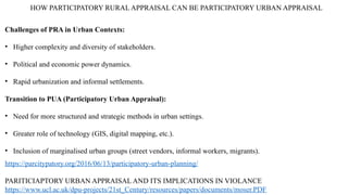
HOW PARTICIPATORY RURALAPPRAISAL CAN BE PARTICIPATORY URBAN APPRAISAL
https://parcitypatory.org/2016/06/13/participatory-urban-planning/
PARITICIAPTORY URBAN APPRAISAL AND ITS IMPLICATIONS IN VIOLANCE
https://www.ucl.ac.uk/dpu-projects/21st_Century/resources/papers/documents/moser.PDF
Challenges of PRA in Urban Contexts:
• Higher complexity and diversity of stakeholders.
• Political and economic power dynamics.
• Rapid urbanization and informal settlements.
Transition to PUA (Participatory Urban Appraisal):
• Need for more structured and strategic methods in urban settings.
• Greater role of technology (GIS, digital mapping, etc.).
• Inclusion of marginalised urban groups (street vendors, informal workers, migrants).
PARTICIPATORY MAPPING
• Theparticipatory rural appraisal (PRA) facilitator can enable the people to map their village
and facilitate an understanding of their situation and condition through the map. Maps can
work magic.
• They are a very effective and immediate source of communication.
• They are vibrant and can be made a dynamic tool to aid communication. They can promote
cross-generational communication and convey a sense of authority.
• They can also promote community cohesion and self-actualisation (Alcorn 2000).
15.
PARTICIPATORY MAPPING
Maps, intheir simplest form, are employed to identify the comparative location and importance
of different resources within an area (Institute of Development Studies 1995).
There are several reasons for using maps in PRA.
• to provide a framework for discussion over the relative location of resources;
• to highlight the resources of importance, using mapping as a spatial guide;
• to raise issues which are affected by these resources;
• to analyse the present status or condition of a location;
• to raise an awareness of the existing facilities or natural resources;
• to create a focus for interest in a discussion over the resources;
• to stimulate debate over the importance of specific resources;
• to develop a basis for comparing different perspectives;
• to create visual presentation which could be understood by everybody; and
• to create a baseline for assessing change, for use as a basis for impact analysis or for
monitoring and evaluation (Mascarenhas et al. 1991).
16.
PARTICIPATORY MAPPING
• SOCIALMAP
• HEALTH MAP
• WATER AND SANITATION MAP
• LEADERSHIP MAP
• RESOURCE MAP
1. PARTICIPATORY AQUIFER MAPPING: CATALYSING A SOCIAL RESPONSE TO MANAGE GROUNDWATER
http://bengaluru.urbanwaters.in/wp-content/uploads/sites/3/2017/08/Participatory-Aquifer-Mapping_final-report-version-2.pdf
2. How community mapping of storm water drains is fighting evictions in Karachi’s informal settlements
https://www.iied.org/how-community-mapping-storm-water-drains-fighting-evictions-karachis-informal-settlements
3. Participatory slum mapping in Cuttack by SPARC
https://www.fig.net/resources/proceedings/fig_proceedings/fig2012/ppt/gltn01/gltn01_kunte_ppt.pdf
4. PARTICIPATORY MAPPING, RELATIONSHIP BUILDING AND ADVOCACY
http://arifhasan.org/wp-content/uploads/2012/10/LessonsfromKarachi-AH-139.pdf
17.
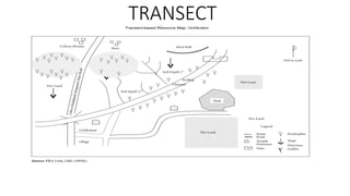
TRANSECT
• Transects areused to explain the spatial dimensions of people’s realities. They are an effective way to learn about rural life
and development, particularly about the complex interaction between man and his environment, of natural resources and
their management, of farm-based livelihoods, about local vegetation and much more
• A transect, however, depicts a cross-sectional view of the different agro-ecological zones and provides a comparative
assessment of these zones on different parameters. Transects differ from historical transects. The focus of transects is
geographical while that of historical transects is on trends or changes on aspects related to natural resources over a span of
time
• There are broadly three categories of transects: (i) village transects, (ii) resource transects and (iii) cultural transects
(Mascarenhas 1992).
https://parcitypatory.org/2017/10/29/transect-walks/
Mapping of Informal Settlements – Muzaffarpur
https://pria.org/knowledge_resource/1519621516_Mapping%20of%20Informal%20Settlements%20-%20Muzaffarpur.pdf
18.
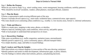
Steps to Conducta Transect Walk
Step 1: Define the Purpose
•What do you want to study? (e.g., street vending zones, waste management, housing conditions, mobility patterns)
•Who should be involved? (residents, vendors, urban planners, municipal officials, students)
Step 2: Plan the Route
•Choose a representative path covering different parts of the area.
•Ensure it includes diverse spaces (e.g., main roads, residential lanes, commercial areas, open spaces).
•The route should cover contrasting urban conditions (e.g., wealthy vs. low-income areas, formal vs. informal settlements).
Step 3: Walk and Observe
•Walk at a steady pace, stopping to take notes, photos, or sketches.
•Observe land use, building types, road conditions, street activity, and public spaces.
•Talk to local people to understand their perspectives on issues.
Step 4: Record Key Findings
•Take notes on problems (e.g., traffic congestion, sanitation issues, encroachment).
•Identify positive aspects (e.g., active community spaces, efficient transport links).
•Use simple sketches, maps, and tables to record findings.
Step 5: Analyze and Map the Insights
•Plot observations on a transect diagram (a cross-section of the area showing variations).
•Identify patterns and trends in urban development, infrastructure gaps, or policy failures.
•Use the findings to inform urban interventions, policies, and planning decisions.
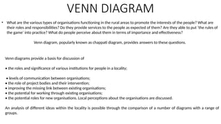
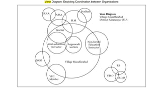
VENN DIAGRAM
• Whatare the various types of organisations functioning in the rural areas to promote the interests of the people? What are
their roles and responsibilities? Do they provide services to the people as expected of them? Are they able to put ‘the rules of
the game’ into practice? What do people perceive about them in terms of importance and effectiveness?
Venn diagram, popularly known as chappati diagram, provides answers to these questions.
Venn diagrams provide a basis for discussion of
• the roles and significance of various institutions for people in a locality;
• levels of communication between organisations;
• the role of project bodies and their intervention;
• improving the missing link between existing organisations;
• the potential for working through existing organisations;
• the potential roles for new organisations. Local perceptions about the organisations are discussed.
An analysis of different ideas within the locality is possible through the comparison of a number of diagrams with a range of
groups.
23.
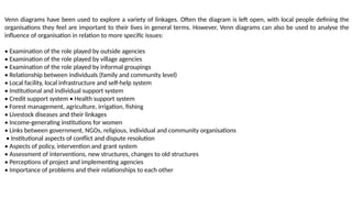
Venn diagrams havebeen used to explore a variety of linkages. Often the diagram is left open, with local people defining the
organisations they feel are important to their lives in general terms. However, Venn diagrams can also be used to analyse the
influence of organisation in relation to more specific issues:
• Examination of the role played by outside agencies
• Examination of the role played by village agencies
• Examination of the role played by informal groupings
• Relationship between individuals (family and community level)
• Local facility, local infrastructure and self-help system
• Institutional and individual support system
• Credit support system • Health support system
• Forest management, agriculture, irrigation, fishing
• Livestock diseases and their linkages
• Income-generating institutions for women
• Links between government, NGOs, religious, individual and community organisations
• Institutional aspects of conflict and dispute resolution
• Aspects of policy, intervention and grant system
• Assessment of interventions, new structures, changes to old structures
• Perceptions of project and implementing agencies
• Importance of problems and their relationships to each other
24.
Other creative methods:Participatory visual methods
• Participatory visual methods include different creative forms of communication and expression, such as
drama, photography, film, drawing, design, creative writing and music. Using collaborative processes,
participants and facilitators work together to produce powerful stories.
• Digital storytelling
• Participatory video
• Drawing
• Photovoice(photography)
• Painting
25.
INTERVIEWING AND DIALOGUE
1.Focusgroups: A discussion held between no more than ten participants led by a
facilitator/researcher.
2.Interviews: Individually administered series of questions to participants.
3.Observation: Annotating participants and their environment by researchers.
26.
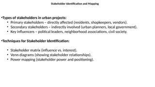
Stakeholder Identification andMapping
•Types of stakeholders in urban projects:
• Primary stakeholders – directly affected (residents, shopkeepers, vendors).
• Secondary stakeholders – indirectly involved (urban planners, local government).
• Key influencers – political leaders, neighborhood associations, civil society.
•Techniques for Stakeholder Identification:
• Stakeholder matrix (influence vs. interest).
• Venn diagrams (showing stakeholder relationships).
• Power mapping (stakeholder power and positioning).
27.
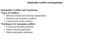
Stakeholder Conflict andNegotiation
Stakeholder Conflict and Negotiation
•Types of conflicts:
• Between formal and informal stakeholders.
• Political and economic conflicts.
• Cultural and social conflicts.
•Techniques for managing conflict:
• Consensus-building methods.
• Interest-based negotiation.
• Multi-stakeholder platforms.
28.
Stakeholder Conflict andNegotiation
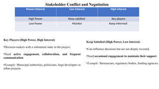
Power/Interest Low Interest High Interest
High Power Keep satisfied Key players
Low Power Monitor Keep Informed
Key Players (High Power, High Interest)
•Decision-makers with a substantial stake in the project.
•Need active engagement, collaboration, and frequent
communication.
•Example: Municipal authorities, politicians, large developers in
urban projects.
Keep Satisfied (High Power, Low Interest)
•Can influence decisions but are not deeply invested.
•Need occasional engagement to maintain their support.
•Example: Bureaucrats, regulatory bodies, funding agencies.
29.
Stakeholder Conflict andNegotiation
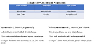
Power/Interest Low Interest High Interest
High Power Keep satisfied Key players
Low Power Monitor Keep Informed
Keep Informed (Low Power, High Interest)
•Affected by the project but lack direct influence.
•Need continuous information sharing and consultation.
•Example: Residents, small businesses, NGOs, civil society
groups.
Monitor (Minimal Effort) (Low Power, Low Interest)
•Not directly affected and have little influence.
•Need basic monitoring with updates as needed.
•Example: General public, students, passive interest groups.