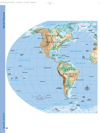
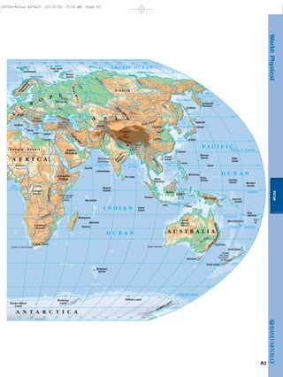
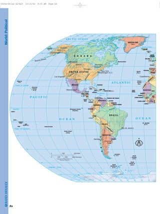
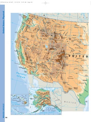
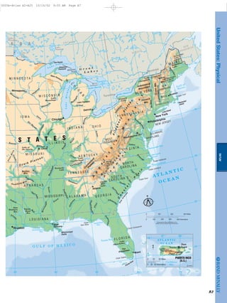
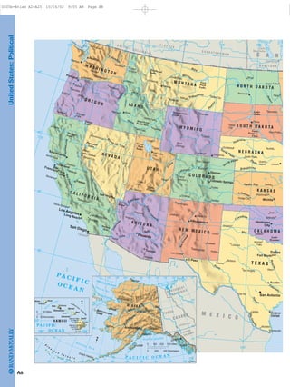
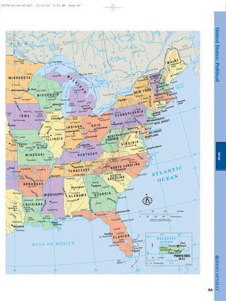
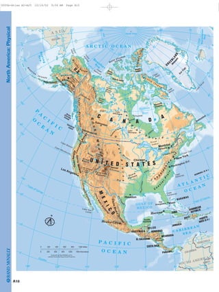
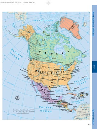
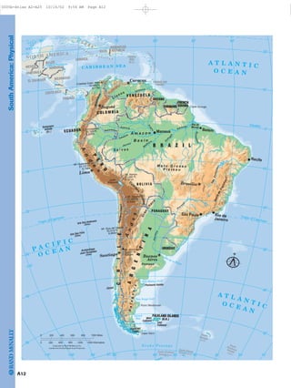
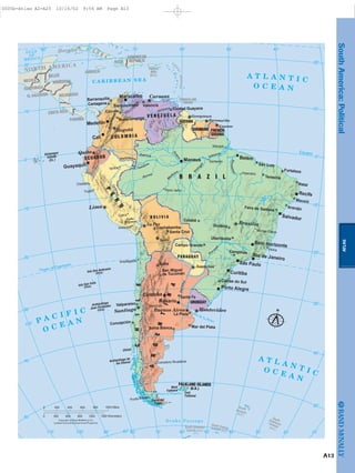
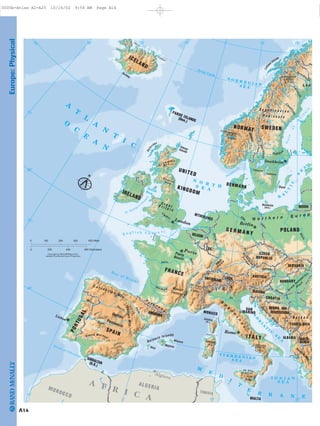
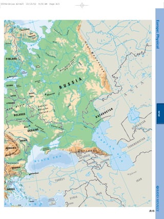
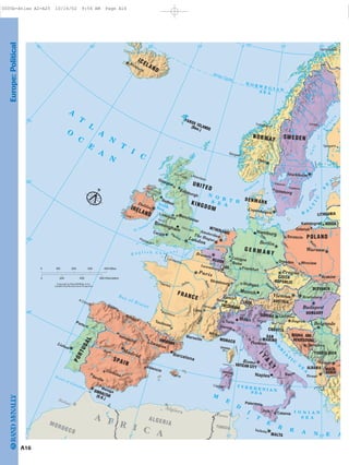
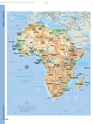
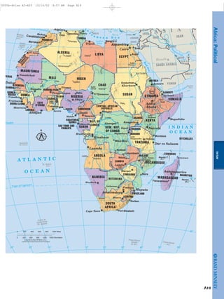
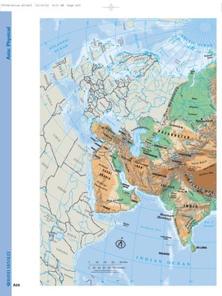
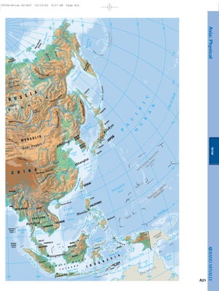
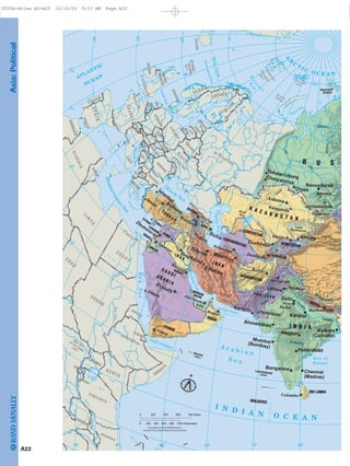
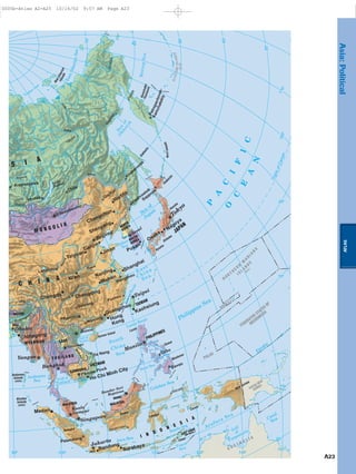
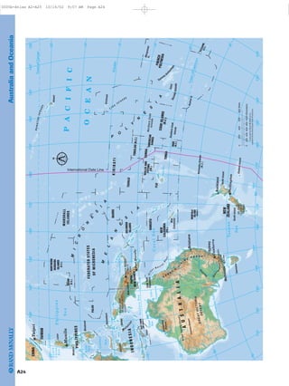
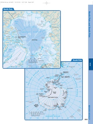
The document contains contents pages for an atlas that divides the world into regions and includes sections on both the physical and political features of each region. The physical sections include maps of the regions showing geographic features like mountains, rivers, lakes, and oceans. The political sections include maps showing country boundaries and possessions. Regions covered include World, North America, South America, Europe, Africa, Asia, Australia/Oceania, and the North and South Poles.
The document contains summaries of maps for different regions: Japan includes the islands of Hokkaido, Honshu, Shikoku, and Kyushu along the Sea of Japan and Pacific Ocean, with major towns including Sapporo, Sendai, Nigata, Tokyo, Yokohama, Nagoya, Osaka, Kobe, and Hiroshima. Amazonia in South America contains the Amazon, Negro, and Xingu Rivers along the Atlantic and Pacific Oceans, with the Andes Mountains forming the western boundary and cities such as Manaus and Belem. The Mediterranean Spain map shows Sicily, Sardinia, the Apennine Mountains, Rome, and coastal regions like the Costa Brava along the
This document contains 7 maps of the world's major physical features labeled with their names and locations. Map 1 shows global directional terms, continents, oceans, seas, islands, mountains, rivers, and inland seas/lakes. Maps 2-3 show more detailed physical features of Europe. Maps 4-6 show physical features of the Americas, Africa, and Asia respectively labeled with oceans, seas, islands, coasts, relief features, and rivers. Map 7 shows the physical features of Oceania labeled with seas, islands, and main landforms. In total, the document contains over 250 labeled physical features of the world.
Kevin Dove is a creative director with extensive experience leading creative teams for TV, film, print, and web projects. He has served as Director of Creative Services for the College of Southern Maryland and created marketing collateral for the Southern Maryland Blue Crabs baseball team. Dove has worked as an animator, effects compositor, web designer, storyboard illustrator, video editor, and voice over actor for various agencies and productions. He brings years of experience in craft and customer service, and aims to foster growth in himself and those he works with through a collaborative approach.
This two-day training program provides an overview of planning and organizing skills. Day one covers the fundamentals of management, planning, and applying a six-step planning process. Day two focuses on the definition and key elements of organizing, as well as delegation. Interactive activities are used to apply planning and organizing concepts to the National Integrated Policy Management Operations (NIPMO) work environment. The training aims to help participants effectively plan and manage resources through goal setting, strategy development, and monitoring outcomes.
This document discusses the importance of planning and organization, outlining key aspects to consider like roles, prioritization, time management, and risk assessment. It emphasizes deciding objectives, assigning responsibilities, and focusing on urgent and important tasks. Examples provided include planning an award ceremony, sports event, or fundraising. The overall message is that effective planning and organization are necessary to achieve goals and ensure events run smoothly.
The document discusses planning and organizing business management. It defines strategic planning as long-term planning that provides broad goals and direction, while operational planning focuses on short-term specific activities. Some key planning tools discussed are goals, budgets, schedules, standards, policies and procedures. The document also examines different types of organizational structures like line, line-and-staff, matrix, and team organizations. Characteristics of a good organization include clear responsibility, accountability, unity of command, and span of control.
This document contains a map of the world showing country boundaries and major cities. It includes lines denoting the equator, tropics, and polar circles. Bodies of water like oceans, seas, gulfs, bays, and lakes are labeled. Antarctic territories claimed by different countries are also indicated.
This document is a map of the world showing all the oceans, seas, gulfs, bays, straits, and major lakes. It labels these bodies of water and provides political boundaries and capitals of independent states and dependent territories around the world.
The document is a map of the world showing country boundaries and major geographic features such as oceans, seas, lakes, and rivers. It includes labels for many cities, islands, and other locations around the world. There are also lines denoting the Tropic of Cancer, Tropic of Capricorn, Arctic Circle, and Antarctic Circle.
The document is a map of the world showing country boundaries and major geographical features such as oceans, seas, lakes, and rivers. It includes the names of many countries, dependent territories, and uninhabited islands. The bottom of the map provides additional information about Antarctic territorial claims and non-claimant countries.
The document is a map of the world showing country boundaries and major geographic features such as oceans, seas, lakes, and rivers. It includes labels for many cities, islands, and other locations around the world. There are also lines denoting the Tropic of Cancer, Tropic of Capricorn, Arctic Circle, and Antarctic Circle.
National Aeronautics and Space Administration (NASA) satellites have captured stunning images of Earth from above. This book showcases some of the most beautiful satellite images of geographic features on Earth. Each image highlights the patterns, colors, and textures visible from space, from the swirling clouds over the Aleutian Islands to the intricate network of dry riverbeds in the Algerian Desert. The book provides a new perspective for appreciating Earth's natural beauty and diversity as seen through the lens of environmental satellites.
This document provides an overview of the geography of Europe, including its location, size in comparison to other continents, various peninsulas and bodies of water, mountain ranges, rivers, capitals, plains, and climate zones. It also briefly discusses population statistics and religious groups in Europe.
The document provides information about the Earth and world geography. It discusses the size and characteristics of the Earth, including its rotation, composition, and physical features. It also summarizes key data about the world's continents, oceans, islands, lakes, rivers, mountains, cities, countries and languages. The summaries focus on rankings and comparisons of these geographic entities and features.
The document provides satellite images taken at night that show various cities around the world lit up, including cities in Europe, North America, South America, Africa, and Asia. Specific cities mentioned include Paris, Barcelona, London, Lisbon, Madrid, the British Islands, Iceland, Canada, cities in Brazil, American cities like Boston, New York, and Los Angeles. Other images show the Alps, Iceland, the Black Sea, Red Sea, and northern Africa.
The document provides satellite images taken at night that show various cities and geographical features lit up across multiple continents. Key details that can be seen in the nighttime photos include major cities in Europe, North America, South America, Africa and Asia, as well as natural landmarks such as the Swiss Alps, Iceland, the Black Sea and the Red Sea. The photos demonstrate the beauty of the Earth when viewed from space at night.
The document provides a series of nighttime satellite images showing cities and regions lit up across multiple continents, including Europe, Africa, North and South America, and parts of Asia. Key areas that are highlighted include Paris, Barcelona, London, the Iberian Peninsula, North Africa, the Canary Islands, Brazil, North America, the Swiss Alps, Lake Leman, Iceland, the Black Sea region, the Red Sea, Egypt, and the Nile River.
The document provides satellite images taken at night that show various cities and geographical features lit up across multiple continents. Key details that can be seen in the nighttime photos include major cities in Europe, North America, South America, Africa and Asia, as well as natural landmarks such as the Swiss Alps, Iceland, the Black Sea and the Red Sea. The photos demonstrate the beauty of the Earth when viewed from space at night.
The document provides satellite images taken at night that show various cities and geographical features lit up across multiple continents. Key details that can be seen in the images include major cities in Europe, Africa, North and South America, the British and Iberian Peninsulas, the Canary Islands, the Swiss Alps, Iceland, the Black Sea region, the Red Sea, and the Nile River valley. The images demonstrate the beauty of the Earth when viewed from space at night.
The document provides satellite images taken at night that show various cities and geographical features lit up across multiple continents. Key details that can be seen in the nighttime photos include major cities in Europe, North America, South America, Africa and Asia, as well as natural landmarks such as the Swiss Alps, Iceland, the Black Sea and the Red Sea. The photos demonstrate the beauty of the Earth when viewed from space at night.
The document provides satellite images taken at night that show various cities and regions around the world lit up, including:
1) European cities like Paris, Barcelona, London, and Madrid during sunset and nightfall.
2) Islands visible from orbit like the British Isles, Iceland, and Canada.
3) Brazilian cities illuminated at night such as Salvador, Rio de Janeiro, and São Paulo.
4) American cities visible from space including Boston, New York, Philadelphia, Washington and cities in Mexico, Canada, and the Caribbean.
وتاملات ابونا داود لمعى عن الصوم و التجربة بوربوينتMamdouh Sobhy
The document contrasts what Satan says to tempt humans versus what Jesus says to counter those temptations. Satan encourages focusing on bodily needs and pleasures, while Jesus emphasizes the importance of spiritual nourishment and obedience to God. When Satan tempts Jesus to turn stones to bread or gain authority by worshipping Satan, Jesus rejects these through scripture. Overall Jesus encourages relying on God rather than giving in to selfish desires.
Assessment and Planning in Educational technology.pptxKavitha Krishnan
In an education system, it is understood that assessment is only for the students, but on the other hand, the Assessment of teachers is also an important aspect of the education system that ensures teachers are providing high-quality instruction to students. The assessment process can be used to provide feedback and support for professional development, to inform decisions about teacher retention or promotion, or to evaluate teacher effectiveness for accountability purposes.
Strategies for Effective Upskilling is a presentation by Chinwendu Peace in a Your Skill Boost Masterclass organisation by the Excellence Foundation for South Sudan on 08th and 09th June 2024 from 1 PM to 3 PM on each day.
This presentation includes basic of PCOS their pathology and treatment and also Ayurveda correlation of PCOS and Ayurvedic line of treatment mentioned in classics.
Thinking of getting a dog? Be aware that breeds like Pit Bulls, Rottweilers, and German Shepherds can be loyal and dangerous. Proper training and socialization are crucial to preventing aggressive behaviors. Ensure safety by understanding their needs and always supervising interactions. Stay safe, and enjoy your furry friends!
How to Manage Your Lost Opportunities in Odoo 17 CRMCeline George
Odoo 17 CRM allows us to track why we lose sales opportunities with "Lost Reasons." This helps analyze our sales process and identify areas for improvement. Here's how to configure lost reasons in Odoo 17 CRM
How to Fix the Import Error in the Odoo 17Celine George
An import error occurs when a program fails to import a module or library, disrupting its execution. In languages like Python, this issue arises when the specified module cannot be found or accessed, hindering the program's functionality. Resolving import errors is crucial for maintaining smooth software operation and uninterrupted development processes.
The simplified electron and muon model, Oscillating Spacetime: The Foundation...RitikBhardwaj56
Discover the Simplified Electron and Muon Model: A New Wave-Based Approach to Understanding Particles delves into a groundbreaking theory that presents electrons and muons as rotating soliton waves within oscillating spacetime. Geared towards students, researchers, and science buffs, this book breaks down complex ideas into simple explanations. It covers topics such as electron waves, temporal dynamics, and the implications of this model on particle physics. With clear illustrations and easy-to-follow explanations, readers will gain a new outlook on the universe's fundamental nature.
A workshop hosted by the South African Journal of Science aimed at postgraduate students and early career researchers with little or no experience in writing and publishing journal articles.
2. A1
ATLAS
Contents
World: Physical. . . . . . . . . . . . A2
World: Political . . . . . . . . . . . . A4
United States: Physical. . . . . A6
United States: Political . . . . . A8
North America: Physical. . . . A10
North America: Political . . . . A11
South America: Physical. . . . A12
South America: Political. . . . A13
Europe: Physical. . . . . . . . . . . A14
Europe: Political . . . . . . . . . . . A16
Africa: Physical. . . . . . . . . . . . A18
Africa: Political . . . . . . . . . . . . A19
Asia: Physical . . . . . . . . . . . . . A20
Asia: Political . . . . . . . . . . . . . A22
Australia and Oceania . . . . . A24
North and South Pole . . . . . . A25
Country
State, Province,
or Territory
Possession
Ocean or Sea
Physical Feature
Island
Lake
Salt Lake
Seasonal Lake
River
Waterfall
Canal
Mountain Peak
Highest Mountain
Peak
Complete Legend for Physical and Political Maps
A T L A N T I C
O C E A N
PUERTO
RICO (U.S.)
Vancouver
O N T A R I O
Los Angeles
Haifa
CHINA
Calgary
Borneo
A l p s
Paris
9,840 and over
6,560 - 9,840
1,640 - 6,560
656 - 1,640
0 - 656
3,000 and over
2,000 - 3,000
500 - 2,000
200 - 500
0 - 200
Land Elevation
Meters Feet
Over 6,560Over 2,000
Water Depth
656 - 6,560
Less than 656
200 - 2,000
Less than 200
Symbols Type Styles Used
to Name Features
Cities
Land Elevation and Water Depths
Boundaries
International
Boundary
Secondary
Boundary
City over
1,000,000 population
City of 250,000 to
1,000,000 population
City under
250,000 population
National Capital
Secondary Capital
(State, Province,
or Territory)
0005a-Atlas Opener S38-A1 10/16/02 9:22 AM Page A1
Page 2 of 26
3. World:Physical
Equator
Tropic of Cancer
Antarctic Circle
Arctic Circle
Tropic of Capricorn
Yukon
M
ackenzie
Mississip
pi
Colorado
Amazon
N
iger
St. Lawrence
Paraná
Orinoco
Gulf of Mexico
Hudson
Bay
Baffin
Bay
A T L A N T I C
O C E A N
O C E A N
P A C I F I C
A R C T I C O C E A N
W e d d e l l
S e a
Caribbean
Sea
Ross
Sea
Vinson Massif
16,066 Ft.
4,897m
Mt. Aconcagua
22,831 Ft.
6,959m
Mt. McKinley
20,320 Ft.
6,194m
Andes
Appalach
ian
Mts.
Atlas
Andes
Mts.
S O U T H
A M E R I C A
N O R T H
A M E R I C A
Marie
Byrd
Land
Patagonia
Mato Grosso
Plateau
Amazon
Basin
GreatPlains
Canadi
an
Shield
RockyMountains Cape Hatteras
Cape Horn
Antarctic
Peninsula
Yucatan
Peninsula
Baja
California
Iberian
Peninsula
Hawaiian
Islands
Aleutian Islands
Midway Is.
Palmyra
Kiribati
Samoa
Islands
Tonga
Is.
Cook
Islands
Marquesas Is.
Easter Island
Chatham Is.
Archipiélago
Juan Fernández
South
Shetland Is.
Falkland Is.
South
Georgia
South
Sandwich Is.
South
Orkney Is.
Tahiti
Galapagos Islands
Tierra del Fuego
Newfoundland
Azores
Canary
Islands
Jan Mayen
Faroe Is.
Trinidad
Puerto Rico
Jamaica
Cuba
Greenland
Iceland
Cape
Verde
Islands
St. Helena
Hispaniola
Baffin
Island
British
Isles
Cape Verde
London
Rio de Janeiro
Buenos Aires
Washington D.C.
Vancouver
Los Angeles
75˚
75˚
60˚
45˚
30˚
15˚
30˚60˚90˚ 45˚105˚120˚135˚150˚165˚
75˚
60˚
45˚
30˚
15˚
15˚
75˚ 30˚60˚90˚ 45˚105˚120˚135˚150˚165˚ 15˚
0˚
180˚
180˚
1000 2000 Miles0
10000 2000 3000 Kilometers
N
Robinson Projection
Copyright by Rand McNally & Co.
A2
0005b-Atlas A2-A25 10/16/02 9:54 AM Page A2
Page 3 of 26
4. ATLAS
Equator
Tropic of Cancer
Tropic of Capricorn
Antarctic Circle
Congo
Volga
O
b
'
Yen
isey
Le
n a
Y
angtze
G
an
ges
D
arling
Nile
Huan
g
M
ekong
Zam
bezi
Don
Indus Am
ur
B a y o f
B e n g a l
Gulf
of Guinea
O C E A N
P A C I F I C
O C E A N
I N D I A N
A R C T I C O C E A N
North
Sea
Black Sea
C
aspian
Sea
M e d i t e r r a n e a n S e a
A r a b i a n
S e a
Red
Sea
South China
Sea
C o r a l S e a
S e a of Okhotsk
B e r i n g
S e a
Sea of Japan
East
China
Sea
Aral
Sea
Aoraki
(Mt. Cook)
12,316 Ft.
3,754m
Kilimanjaro
19,340 Ft.
5,895m
Mt. Elbrus
18,510 Ft.
5,642m
Mt. Everest
29,035 Ft.
8,850m
Caucasus
Zagros
M
ts.
UralMts.
Alps
Pamir
A N T A R C T I C A
A F R I C A
A S I A
E
U
R
O
P E
A U S T R A L I A
Madagascar
Sri Lanka
Gobi Desert
Great
Sandy
Desert
G
rea
tDividingRange
Victoria Land
Wilkes LandEnderby
LandQueen Maud
Land
S ahara Desert
S a h e l
Congo
Basin
RiftValley
Kalahari
Desert
Deccan
Plateau
Himalayas
Plateau
of
Tibet
Altai M
ts.
S i b e r i a
Ethiopian
Plateau
Cape of Good Hope
North Cape
Cape Leeuwin
Kamchatka
Peninsula
Malay
Peninsula
Scandinavian
Peninsula
Balkan
Peninsula
Arabian
Peninsula
Spitsbergen
Franz Josef
Land
Novaya
Zemlya
Crete Cyprus
Socotra
Lakshadweep
Maldive
Islands
Seychelles
Kerguelen
Islands
Sumatra
Cocos
Island
New Guinea
Palau
Islands Caroline
Islands
Solomon
Islands
Marshall
Islands
Tasmania
South Island
North Island
New Caledonia
New
Hebrides
Fiji
Is.
Java
Borneo
Hainan
Island
Guam
Mariana
Islands
Kyushu¯ ¯
Sakhalin
Honshu¯
Hokkaido¯
Wake
Island
Mauritius
Reunion
Taiwan
Luzon
Mindanao
Celebes
Sardinia
Sicily
Timor
Moscow
Cairo
Cape Town
Mumbai
(Bombay)
Beijing
Sydney
60˚15˚ 30˚ 90˚ 120˚ 135˚ 150˚ 165˚75˚45˚
75˚
60˚
45˚
30˚
15˚
75˚
60˚
45˚
30˚
15˚
105˚
60˚15˚ 30˚ 90˚ 120˚ 135˚ 150˚ 165˚75˚45˚ 105˚
0˚
180˚
180˚
A3
World:Physical
0005b-Atlas A2-A25 10/16/02 9:54 AM Page A3
Page 4 of 26
5. World:Political
Equator
Tropic of Cancer
Antarctic Circle
Arctic Circle
Tropic of Capricorn
Yukon
Missouri
Mississip
pi
Colorado
Amazon
N
iger
Gulf of Mexico
Hudson
Bay
Baffin
Bay
A T L A N T I C
O C E A NO C E A N
P A C I F I C
A R C T I C O C E A N
W e d d e l l
S e a
Caribbean
Sea
Hawaiian
Islands
(U.S)
Aleutian Islands
Easter Island
(Chile)
South
Shetland Is.
(U.K.)
South
Georgia
(U.K.)
South
Orkney Is.
(U.K.)
Galapagos Islands
(Ecuador)
Newfoundland
Azores
(Port.)
Canary
Islands
(Sp.)
Anchorage
Vancouver
Los Angeles
Chicago
Houston
Mexico City
New York
Ottawa
Montréal
Washington D.C.
Caracas
Buenos
Aires
Santiago
Lima
Rio de Janeiro
Casablanca
London
Madrid
ALASKA
(U.S.)
KIRIBATI
AMERICAN
SAMOA
SAMOA
TONGA
COOK
ISLANDS (N.Z.)
FRENCH POLYNESIA
RUSSIA
C A N A D A
U N I T E D S T A T E S
COLOMBIA
VENEZUELA
MEXICO
GUYANA
SURINAME
FRENCH GUIANA
TRINIDAD AND TOBAGO
PANAMA
COSTA
RICA
NIC.
HOND.GUAT.
BELIZE
CUBA
JAMAICA
HAITI
DOM. REP.
BAHAMAS
ECUADOR
EL. SAL.
PUERTO RICO (U.S.)
BOLIVIA
PARAG
UAY
PERU
ARGENTINA
B R A Z I L
CHILE
URUGUAY
IRELAND
UNITED
KINGDOM
FRANCE
ICELAND
PORTUGAL
GREENLAND
(Den.)
FAROE IS.
(Den.)
SPAIN
MALI
LIBERIA
SIERRA LEONE
GUINEAGUINEA-BISSAU
SENEGAL
M
O
R O C C O
CAPE
VERDE
MAURITANIA
W.SAHARA
BURK.
FASO
COTE
D'IVOIRE
ST. HELENA
(U.K.)
FALKLAND IS.
(U.K.)
MIDWAY IS.
(U.S.)
GAMBIA
GHANA
75˚
75˚
60˚
45˚
30˚
15˚
30˚60˚90˚ 45˚105˚120˚135˚150˚165˚
75˚
60˚
45˚
30˚
15˚
15˚
75˚ 30˚60˚90˚ 45˚105˚120˚135˚150˚165˚ 15˚
0˚
180˚
180˚
1000 2000 Miles0
10000 2000 3000 Kilometers
N
Robinson Projection
Copyright by Rand McNally & Co.
A4
0005b-Atlas A2-A25 10/16/02 9:55 AM Page A4
Page 5 of 26
6. Equator
Tropic of Cancer
Tropic of Capricorn
Antarctic Circle
Congo
Volga
O
b
'
Yen
isey
Le
n a
Chang Jiang
G
an
ges
D
arling
Nile
(Y
angtze)
B a y o f
B e n g a l
O C E A N
P A C I F I C
O C E A N
I N D I A N
A R C T I C O C E A N
North
Sea
Black Sea
C
aspian
Sea
M e d i t e r r a n e a n S e a
Arabian
Sea
Red
Sea
South China
Sea
C o r a l S e a
S e a of Okhotsk
B e r i n g
S e a
Sea of Japan
Spitsbergen
(Nor.)
Franz Josef
Land
Novaya
Zemlya
Crete
Kerguelen
Islands
(Fr.)
Sumatra
New Guinea
Tasmania
Java
Borneo
Mumbai
(Bombay)
Cape Town
Rome
Lagos
Addis
Ababa
Cairo
Moscow Novosibirsk
Kolkata
(Calcutta)
Bangkok
Guangzhou
Shanghai
Beijing
Tokyo
Jakarta
Darwin
Melbourne
Perth Sydney
Wellington
BEL.
DEN.
NORWAY
SWEDEN
FINLAND
HUNG.
AUS.
CZ.
YUGO
.
SLVK.
BOS.
MA.ALB.
MOLD.
CRO.
GERMANY
BELARUS
ITALY
P O L A N D
UKRAINE
ROM.
NETH.
LITH.
LAT.
EST.
BUL.
SYRIA
I R A Q
LEB.
ISRAEL
JORDAN
GEO.
AZER.ARM.
TUNISIA
TURKEY
SWITZ.
CYPRUS
GREECE
NIGER
ALGERIA
L I B Y A EGYPT S A U D I
A R A B I A
NIGERIA
CHAD S U D A N
EQUATORIAL
GUINEA
CENTRAL
AFRICAN
REPUBLIC
G ABON
TANZANIA
ZAMBIA
REP. OF
CONGO
KENYA
UGANDA
BURUNDI
R WANDA
CAMEROON
NAMIBIA
ANGOLA
DEM. REP.
OF CONGO
E T H I O P I A
DJIBOUTI
YEMEN
ERIT
R E A
S
O
M
A
LIA
COMOROS
SEYCHELLES
BOTSWANA
ZIMBABWE
MALAWI
SOUTH
AFRICA
MOZAMBIQUE
SWAZILAND
LESOTHO
MADAGASCAR
REUNION
(Fr.)
MAURITIUS
OMAN
U.A.E.
QATAR
KUWAIT
TAJIK.
KYRG.
AFGHANISTAN
PAKISTAN
TURKMENISTAN
I R A N
K A Z A K H S T A N
I N D I A
U Z B E K I S TAN
N E P A L
SRI LANKA
THAILAND
MYANMAR
LAOS
BHU.
BNGL.
C H I N A
M O N G O L I A
R U S S I A
MALDIVES
SINGAPORE
BRUNEI
CAMBODIA
VIETNAM
I N D O N E S I A
PHILIPPINES
TAIWAN
MALAYSIA
PALAU
FED. STATES OF
MICRONESIA
SOLOMON
ISLANDS
MARSHALL
ISLANDS
GUAM (U.S.)
NORTHERN
MARIANA ISLANDS
(U.S.) WAKE ISLAND
(U.S.)
PAPUA
NEW GUINEA
VANUATU
FIJI
(Fr.)
NEW CALEDONIA
A U S T R A L I A
NEW ZEALAND
NORTH
KOREA
SOUTH
KOREA
JAPAN
EAST TIMOR
BENIN
A N T A R C T I C A
60˚15˚ 30˚ 90˚ 120˚ 135˚ 150˚ 165˚75˚45˚
75˚
60˚
45˚
30˚
15˚
75˚
60˚
45˚
30˚
15˚
105˚
60˚15˚ 30˚ 90˚ 120˚ 135˚ 150˚ 165˚75˚45˚ 105˚
0˚
180˚
180˚
ATLAS
A5
World:Political
0005b-Atlas A2-A25 10/16/02 9:55 AM Page A5
Page 6 of 26
7. UnitedStates:Physical
A6
Granite Peak12,799 Ft.3,901m
Mt. Hood11,239 Ft.3,426m
Mt. Saint Helens8,364 Ft.2,549m
Baldy Peak11,404 Ft.3,476m
Grand Teton13,770 Ft4,197m
Harney Peak
7,242 Ft.
2,207m
Kings Peak13,528 Ft.4,123m
Mt. Shasta14,162 Ft.4,317m
Wheeler Peak13,064 Ft.3,982m
Emory Peak
7,825 Ft.
2,385m
Telescope Peak
11,050 Ft.3,368m
Mt. McLoughlin
9,495 Ft.2,894m
Borah Peak12,662 Ft.3,859m
Wheeler Peak13,161 Ft.
4,011m
Pikes Pk.
14,110 Ft.
4,301m
Mt. Taylor11,301 Ft.3,445m
Humphreys Peak12,633 Ft.3,851m
Mt. Rainier14,410 Ft.4,392m
Mt. Olympus7,965 Ft.2,428m
Cloud Peak
13,167 Ft.4,013m
Longs Peak
14,255 Ft.
4,345m
Mt. Elbert
14,433 Ft.
4,399m
Mt. Whitney14,494 Ft.4,418m
Guadalupe Pk.8,749 Ft.
2,667m
R
o
c
k
y
M
o
u
n
t
a
ins
S
ie
rra
Nevada
C
a
s
c
a
d
e
R
a
n
g
e
BitterrootRang
e
Salmon RiverMountains
WasatchRange
Coast
Ranges
Sacramento
PeloncilloMts.
Mts.
CoastRanges
Blue
M
ts.
SanJuanMts.
Uinta
Mts.
Absaroka
Range
BighornMts.
FrontRange
SangredeCristoMountains
OlympicMts.
G r e a t
B a s i n
Black
Hills
Harney
Basin
CentralValley
Death
Valley
Mojave Desert
Grand Canyon
C o l o r a d o
P l a t e a u
Great
Divide
Basin
G
rea
t
P
l
a
i
n
s
Edwards
Plateau
Stockton
Plateau
L l a n o
E s t a c a d o
Point Arguello
CapeMendocino
CapeFlattery
CapeBlanco
Willamette
Deschutes
Utah
Lake
Bighorn
Marias
T
ongue
White
Lake
Sakakawea
Missouri
Brazos
Sheyenne
Red
Moreau
Cheyenne
North Loup
C
i
m
arron
FlamingGorge
Res.
Clark
F
ork
PugetSound
San Juan
ChannelIslands
Padre
IslandM E X I C O
C A N
U N I T E D
P A C I F I CO C E A N
W A S H I N G T O N
I D A H O
W Y O M I N G
O R E G O N
M O N T A N A
C A L I F O R N I A
N E V A D A
U T A H
A R I Z O N A
K A N S A S
C O L O R A D O
O K L A H O M A
N E W M E X I C O
N E B R A S K A
N O R T H D A K O T A
S O U T H D A K O T A
T E X A S
M A N I T O B A
S A S K A T C H E W A N
B R I T I S H C O L U M B I A
A L B E R T A
Tropic of Cancer
Gulf
of
California
RioGrande
Pecos
Colorado
Gila
Colora
d
o
SanJoaquin
Sacramento
Columbia
Snake
Salm
on
Colum
bia
Miss
ou
ri
Milk
Yellowstone
P
ow
d
e
r
Jam
es
Smoky Hill
Republican
Platte
North Platte
S
outh Platte
Niobrara
C
olorado
Gree
n
Sna
k
e
H
um
boldt
RioGrande
Colorad
o
Canadian
Red
LittleCol
ora
do
Salt
Lake
Mead
Salton
Sea
Lake Tahoe
PyramidLake
ShastaLake
GooseLake
Great
Salt
Lake
Lake
Powell
AmericanFalls Res.
FlatheadLake
Lake
Oahe
Lake
Francis
Case
Fort
Peck
Lake
YellowstoneLake
Lake
Texoma
Nue
ces
Arkansas
Seattle
SanFrancisco
Denver
Los Angeles
Phoenix
Dallas
125˚ 120˚
115˚
110˚50˚
105˚ 100˚
100˚105˚110˚115˚
45˚
35˚
30˚
40˚
25˚
125˚
120˚
Tanana
Yukon
Yukon
Kusko
k
w
im
Arctic Circle
Gulf of Alaska
Bristol
Bay
Bering Strait
Prudhoe
Bay
Alaska Peninsula
Kenai
Pen.
Mt. McKinley
20,320 Ft.
6,194m
Point
Barrow
A
l a s k a
R a n g e
B
r o o k s R a n g
e
Saint Lawrence
Island
Kodiak
Island
A
l e
u
t
i a n
I s l a n d s
P A C I F I C O C E A N
B e r i n g S e a
Chukchi Sea
Beaufort
ARCTIC OCEAN Sea
YUK ON
NORTHWEST
BRITISH
COLUMBIA
TERRITORIES
CANA DA
RUSSIA
ALAS KA
FairbanksNome
Juneau
Valdez
Anchorage
RMcN..C
N
170˚ 165˚ 160˚ 155˚ 150˚ 145˚ 140˚ 135˚ 130˚
125˚
175˚
65˚
70˚ 70˚
65˚
60˚
135˚140˚145˚150˚155˚160˚165˚
130˚
125˚
60˚
55˚
55˚
170˚175˚180˚
185˚
120˚
200 300 Miles0 100
0 200 400 Kilometers
K
a
uai Channel
Mauna Kea
13,796 Ft.
4,205m
Mauna Loa
13,679 Ft.
4,169m
H a w a i i a n
I s lan
ds
Hawaii
Maui
Oahu
Molokai
Lanai
Kahoolawe
KauaiNiihau
PACI FIC
OCE AN
Kalaheo
Hilo
Wahiawa
Honolulu
RMcN..C
N
0
0 50 Miles
50 Kilometers
155˚160˚
20˚ HAWAII
0005b-Atlas A2-A25 10/16/02 9:55 AM Page A6
Page 7 of 26
8. ATLAS
A7
Mt. Katahdin
5,268 Ft.
1,606m
Mt. Washington
6,288 Ft.
1,917m
Mt. Mitchell
6,684 Ft.
2,037m
A
p
p
a
l
a
c
h
i
a
n
M
o
u
n
t
a
i
n
s
Adirondack
Mountains
B
l
u
e
R
i
d
g
e
FlintHills
Ou ach ita Mts.
Boston
Mts.
Catskill
Mts.
GreenMts.
White
Mts.
O z a r k P l a t e a u
C
um
berland
Plateau
The
Everglades
C
o
a
s
t
a
l
P
l
a
in
Sea
Islands
P
i
e
d
m
o
n
t
Allegheny
Platea
u
Mississippi
Delta
Bruce
Peninsula
Keweenaw
Peninsula
Lower Peninsula
Upper Peninsula
Cape
San Blas
Cape Cod
Cape Fear
Cape Lookout
Cape Hatteras
Cape Canaveral
Cape Sable
Whitefish
Point
Clarks
Hill
Lake
Whit
e
Des
M
oines
Iow
a
Kansas
Neosho
Lake of
the Ozarks
St.Law
rence
Mus
kegon
Grand
Maum
ee
Scioto
Tennessee
S
uwannee
Santee
PeeD
e
e
James
Lake
Erie
Connecticut
Sabine
Yazoo
Pearl
Alaba
m
a
Flint
C
ape Fear
Green
W
hite
Lake
Cumberland
Wiscon
s
in
M
innesota
Chi
pp
e
wa
Lake
Winnebago
Allegh
e
ny
Kennebec
Mississippi
Niagara
Falls
G r e a t
L a k e s
Long Island
Florida Keys
Tampa Bay
Atchafalaya
Bay
Apalachee
Bay
Sagi
naw
Bay
Green
Bay
Pamlico Sound
Chesapeake Bay
A D A
B A H A M A S
S T A T E S
M
I C
H
I
G
A
N
M I N N E S O T A
I O W A
W I S C O N S I N
A R K A N S A S
L O U I S I A N A
MISSISSIPPI
M I S S O U R I
A L A B A M A
T E N N E S S E E
G E O R G I A
K E N T U C K Y
F L O R I D A
NORTH
CAROLINA
SOUTH
CAROLINA
I L L I N O I S
I N D I A N A O H I O
P E N N S Y L V A N I A
V I R G I N I A
NEW YORK
WEST
VIRGINIA
DELAWARE
MARYLAND
NEW JERSEY
CONNECTICUT R.I.
MASS.
VERMONT
NEW
HAMPSHIRE
M A I N E
O N T A R I O
Q U É B E C
NEW
BRUNSWICK
Isle Royale
Nantucket
Island
A T L A N T I C
O C E A N
G U L F O F M E X I C O
Georgian
Bay
Delaware Bay
Albemarle
Sound
Gulf of
Maine
Tri
nity
R
ed
O
uac
hita
A
rkansas
Missouri
Illin
ois
Wabash
O
h
io
Ohio
Cumberlan
d
Tombigbee
Chattahoochee
Altamaha
S
ava
nn
ah
R
o
a
n
oke
S
usqu
e
h
anna
Hudson
Toledo
Bend
Res.
Sam
Rayburn
Res.
Kentucky
Lake
L a k e S u p e r i o r
Lake of
the
Woods
Lake
Nipigon
Lake Huron
Lake Ontario
Lake
Champlain
Lake
Okeechobee
Moosehead
Lake
Lake
Winnipeg
Mississippi
Mississippi
LakeMichigan
Minneapolis
St. Louis
Miami
Atlanta
Boston
New
Orleans
Detroit
Houston
Chicago
Montréal
Toronto
New York
Philadelphia
Washington D.C.
90˚95˚ 80˚85˚ 70˚
75˚
45˚
40˚
35˚
30˚
25˚
75˚80˚85˚90˚95˚
70˚
50˚
N
Copyright by Rand McNally & Co.
Alber’s Conic Equal Area Projection
300 Miles0
0
100 200
100 200 400 Kilometers300
67 ° 66 °
18 °
19 °
San
Juan
N
AT L A N T I C
O C E A N
Caribbean
Sea
Arecibo
Caguas
Mayagüez
Ponce
RMcN..C
0
25 50 Kilometers0
25 50 Miles PUERTO RICO
(U.S.)
UnitedStates:Physical
0005b-Atlas A2-A25 10/16/02 9:55 AM Page A7
Page 8 of 26
9. UnitedStates:Political
A8
Tropic of Cancer
Gulf
of
California
RioGrande
Pecos
Colorado
Gila
Colora
d
o
SanJoaquin
Sacramento
Columbia
S
nake
Salm
on
Colum
bia
Miss
ou
ri
Milk
Yellowstone
P
ow
d
e
r
Jam
es
Smoky Hill
Republican
Platte
North Platte
S
outh Platte
Niobrara
C
olorado
Gree
n
Sna
k
e
H
um
boldt
RioGrande
Colorad
o
Canadian
Red
LittleCol
ora
do
Salt
Lake
Mead
Salton
Sea
Lake Tahoe
PyramidLake
ShastaLake
GooseLake
Great
Salt
Lake
Lake
Powell
AmericanFalls Res.
FlatheadLake
Lake
Oahe
Lake
Francis
Case
Fort
Peck
Lake
YellowstoneLake
Lake
Texoma
Nue
ces
Arkansas
Lake
Manitoba
Brazos
M A N I T O B A
S A S K A T C H E W A N
B R I T I S H C O L U M B I A
A L B E R T A
W A S H I N G T O N
I D A H O
W Y O M I N G
O R E G O N
M O N T A N A
C A L I F O R N I A
N E V A D A
U T A H
A R I Z O N A
K A N S A S
C O L O R A D O
O K L A H O M A
N E W M E X I C O
N E B R A S K A
N O R T H D A K O T A
S O U T H D A K O T A
T E X A S
P A C I F I CO C E A N
M E X I C O
C A N
Pierre
Cheyenne
Bismarck
Helena
Boise
Olympia
Salem
Carson City
Salt LakeCity
Santa Fe
Lincoln
Austin
Oklahoma
City
Denver
Sacramento
Phoenix
Spokane
Tacoma
Amarillo
Lubbock
Pueblo
Riverside
Stockton
Wichita
Falls
San Bernardino
Eugene
Laredo
Waco
Reno
Billings
Laramie
Sheridan
Rock
Springs
Durango
Alamogordo
Yakima
Coeur
d'Alene
Pendleton
Winnemucca
Elko
Bozeman
Scottsbluff
Dodge City
Ely
Gallup
Cedar
City
Aberdeen
Bellingham
Fargo
Grand Forks
Great Falls
Lewiston
Minot
Missoula
Bakersfield
Midland
Boulder
Brownsville
Casper
Clovis
Enid
Eureka
Flagstaff
Grand
Island
Grand
Junction
McAllen
Hobbs
Hutchinson
North Platte
Lawton
Logan
Medford
Modesto
Monterey
Nampa
Norfolk
Odessa
Ogden
Pocatello
Provo
Rapid
City
Roswell
Salina
Santa Barbara
Santa Rosa
Sioux Falls
Stillwater
Yuma
San Angelo
Las Cruces
Twin Falls
Fort Collins
Idaho Falls
Del Rio
Farmington
Trinidad
Butte
Miles City
St. George
Moab
Prescott
Nogales
KlamathFalls
Bend
Corvallis
Kennewick
Winnipeg
Portland
Seattle
Albuquerque
El Paso
Long Beach
OaklandSanFrancisco
Tucson
Wichita
Fort Worth
SanJose
Colorado Springs
Corpus
Christi
Chihuahua
Tijuana
Fresno
Las Vegas
Los Angeles
San Diego
Dallas
San Antonio
125˚ 120˚
115˚
110˚50˚
105˚ 100˚
100˚105˚110˚115˚
45˚
35˚
30˚
40˚
25˚
125˚
120˚
Yukon
Yu
kon
K
usk
okwim
Arctic Circle
Gulf of Alaska
Bering
Strait
Saint Lawrence
Island
A
l e
u
t i a n
I s l a n d s
B e r i n g S e a
Chukchi Sea
ARCTIC OCEAN
P A C I F I C O C E A N
Beaufort
Sea
YUK ON
NORTHWEST
BRITISH
COLUMBIA
TERRITORIES
CANA DA
RUSSIA
ALA S KA
Fairbanks
Nome
Juneau
Valdez
Barrow
Dutch Harbor
Seward
Kodiak
Whitehorse
Sitka
Kotzebue
Bethel Anchorage
RMcN..C
N
Alaska
Pipeline
170˚ 165˚ 160˚ 155˚ 150˚ 145˚ 140˚ 135˚ 130˚
125˚
175˚
65˚
70˚ 70˚
65˚
60˚
135˚140˚145˚150˚155˚160˚165˚
130˚
125˚
60˚
55˚
55˚
170˚175˚180˚
185˚
120˚
200 300 Miles0 100
0 200 400 Kilometers
K
auai Channel
Mauna Kea
13,796 Ft.
4,205m
Mauna Loa
13,679 Ft.
4,169m
H a w a i i a n
I s lan
ds
Hawaii
Maui
Oahu
Molokai
Lanai
Kahoolawe
KauaiNiihau
PACI FIC
OCE AN
Kalaheo
Hilo
Wahiawa
Honolulu
RMcN..C
N
155˚160˚
20˚
0
0 50 Miles
50 Kilometers
HAWAII
0005b-Atlas A2-A25 10/16/02 9:55 AM Page A8
Page 9 of 26
10. ATLAS
A9
Isle Royale
Nantucket
Island
A T L A N T I C
O C E A N
G U L F O F M E X I C O
Georgian
Bay
Delaware Bay
Albemarle
Sound
Gulf of
Maine
Tri
nity
R
ed
O
uac
hita
A
rkansas
Missouri
Illin
ois
Wabash
O
h
io
Ohio
Cumberlan
d
Tombigbee
Chattahoochee
Altamaha
S
ava
nn
ah
R
o
a
n
oke
S
usqu
e
h
anna
Hudson
Toledo
Bend
Res.
Sam
Rayburn
Res.
Kentucky
Lake
L a k e S u p e r i o r
Lake of
the
Woods
Lake
Nipigon
Lake Huron
Lake Ontario
Lake
Champlain
Lake
Okeechobee
Moosehead
Lake
Lake
Winnipeg
Mississippi
Mississippi
LakeMichigan
DesMoines
Missou
ri
St.Law
rence
Lake Erie
Connecticut
O N T A R I O
Q U É B E C
NEW
BRUNSWICK
M
I C
H
I
G
A
N
M I N N E S O T A
I O W A
W I S C O N S I N
A R K A N S A S
L O U I S I A N A
MISSISSIPPI
M I S S O U R I
A L A B A M A
T E N N E S S E E
G E O R G I A
K E N T U C K Y
F L O R I D A
NORTH CAROLINA
SOUTH
CAROLINA
I L L I N O I S
I N D I A N A O H I O
P E N N S Y L V A N I A
V I R G I N I A
NEW YORK
WEST
VIRGINIA
DELAWARE
MARYLAND
NEW JERSEY
CONNECTICUT
R.I.
MASSACHUSETTS
VERMONT
NEW
HAMPSHIRE
M A I N E
Long Island
A D A
B A H A M A S
Pamlic
o
Sound
ChesapeakeBay
Providence
Augusta
Montpelier
Concord
Hartford
Trenton
Albany
Harrisburg
Annapolis
Dover
Richmond
Raleigh
Charleston
Columbia
Tallahassee
Montgomery
Frankfort
Springfield
Lansing
Madison
Des Moines
Jefferson
City
Topeka
Little Rock
Jackson
Baton
Rouge
Boston
Atlanta
Nashville
Indianapolis
Columbus
St. Paul
Ottawa
Washington D.C.
Nassau
Grand
Duluth
Allentown
Beaumont
Bridgeport
Chattanooga
Columbus
Davenport
Dayton
Daytona Beach
Durham
Evansville
Flint
Gary
Greensboro
Huntsville
Knoxville
Lexington
Macon
Moline
Orlando
Peoria
Racine
Savannah
Shreveport
Springfield
St. Petersburg
Syracuse
Worcester
Youngstown
South
Bend
Fort
Lauderdale
Fort Wayne
Rapids
Winston-
Salem
Cedar
Rapids
Rockford
Mobile
Rochester
Norfolk
Traverse
City
Marquette
Sioux
City
St. Cloud
Albany
Appleton
Asheville
Huntington
Athens
Augusta
Bangor
Gulfport
Binghamton
Bloomington
Burlington
Charleston
Clarksville
Columbia
Muncie
Aurora
Decatur
Dothan
Dubuque
Eau Claire
Erie
Fayetteville
Fort
Smith
Gainesville
Galveston
Greenville
Hattiesburg
Johnson City
Jonesboro
Kalamazoo
Lakeland
Lima
Springfield
Mankato
Monroe
Muskogee
Owensboro
Pensacola
Portland
Roanoke
Rochester
Saginaw
Scranton
Sheboygan
St. Joseph Terre Haute
Texarkana Tuscaloosa
Watertown
West
Palm Beach
Wilmington
Wilmington
Lafayette
Waterloo
Green Bay
Oil City
Pine Bluff
Fort Myers
Cape
Girardeau
Manchester
Key
West
Newport News
Akron
Sault Ste. Marie
Bloomington
International
Falls
Emporia
Tyler
Lake
Charles
Ann Arbor
OshKosh
Kansas
City
Omaha
Tulsa
Baltimore
Birmingham
Charlotte
Cincinnati
Cleveland
Jacksonville
Kansas
City Louisville
Memphis
Miami
Milwaukee
Minneapolis
New
Orleans
Pittsburgh
St. Louis
Tampa
Toledo Newark
Buffalo
Virginia Beach
Detroit
Montréal
Toronto
Chicago
New York
Philadelphia
Houston
90˚95˚ 80˚85˚ 70˚
75˚
45˚
40˚
35˚
30˚
25˚
75˚80˚85˚90˚95˚
70˚
50˚
300 Miles0
0
100 200
100 200 400 Kilometers300
N
Copyright by Rand McNally & Co.
Alber’s Conic Equal Area Projection
67 ° 66 °
18 °
19 °
San
Juan
N
AT L A N T I C
O C E A N
Caribbean
Sea
Arecibo
CaguasMayagüez
Ponce
RMcN..C
0
25 50 Kilometers0
25 50 Miles
PUERTO RICO
(U.S.)
UnitedStates:Political
0005b-Atlas A2-A25 10/16/02 9:55 AM Page A9
Page 10 of 26
11. Mt. Whitney14,494 Ft.4,418m
M
t. Logan
19,551
Ft.
5,959m
M
t. M
cKinley
20,320
Ft.
6,194m
RockyMountains
Alaska Ra
nge
SierraMadreOrienta
l
SierraMadre
Occidental
A
p
p
a
la
c
h
ia
n
M
ts.
SierraNevada
CoastRanges
Cascade
Range
CoastMountains
Brooks
R
a n g e
Ice
Cap
G
re
atPlains
C
a
n
a
d
i
a
n
S
h i e l d
C
o
a
s
ta
l
P
lain
The
Everglades
PlateauOzark
ColoradoPlateau
GreatBasin
Péninsule
d'Ungava
Yucatán
Peninsula
BajaCalifornia
Alaska Peninsula
QueenCharlotte
Islands
VancouverIsland
Point
Hope
Point
Barrow
Cape
Adair
Cape
Mercy
Cape
Canaveral
Cape Cod
Cape
Hatteras
Cape BlancoCape Mendocino
Cabo San
Lucas
Bathurst
Cape
Cape
Farvel
Gulf of
Campeche
Foxe
Basin
James
Bay
Niagara Falls
Alb
a
ny
Kuskokwim
Snake
Red
M
issouri
Lake
Athabasca
Great
Lakes
Norwegian
Sea
U N I T E D S T A T E S
GRE
ENLAND
U.S.
M
EX
IC
O
C
A N A D
A
BELIZE
CUBA
EL SALVADOR
GUATEMALA
HAITI
JAMAICA
NICARAGUA
DOMINICAN
REPUBLIC
BAHAMAS
COSTA RICA
PANAMA
HONDURAS
ICELAND
PUERTO
RICO (U.S.)
(
Denmark)
BERMUDA (U.K.)
COLOMBIA
VENEZUELA
BRAZIL
RUSSIA
EllesmereIsland
B a f f i n
I s l a
n
d
Ale
u
t i a n
I s l a n d s
Queen Elizabeth
Islands
Newfoundland
Devon
Island
Victoria Island
BanksIsland
St.
Lawrence
Y
ukon
C
o
lorado
GreatBearLakeMackenzie
GreatSlaveLake
Peace Saskat
chewan
Nelson
Lake
Winnipeg
C
o
lumbia
GreatSalt
Lake
LakeMichigan
Arkansas
Mississippi
Rio
Gra
nde
Lago de
Nicaragua
Lake Superior
Lak
e
Huron
LakeErie
L.Ontario
O
hio
Bering
Sea
B
eaufort
Sea
A R C T I C O C E A N
P
A
C
I
F
I C
O
C
E
A
N
A T L A N T I C
O C E A N
C A R I B B E A N
S E A
P A C I F I C
O C E A N
GULF OF
MEXICO
Baffin Bay
G
ulf of Alaska
Bering Str
ait
Gulf of
St. Lawrence
Golfo
de
Panamá
Bay
Hudson
Prudhoe
B
ay
Gulf
of
California
Tropic of Cancer
North Pole
ArcticCircle
Equator
ArcticCircle
Tropic of Cancer
SOUTH AMERICA
A S I A
Churchill
Whitehorse
Edmonton
Vancouver
Denver
Miami
Ottawa
Washington D.C.
Anchorage
Los Angeles
Mexico City
Havana
Chicago
Montréal
New York
Houston
60˚ 70˚
170˚
80˚ 70˚80˚
120˚ 110˚130˚ 90˚ 80˚ 70˚100˚
140˚
150˚
160˚
10˚
50˚
30˚
40˚
170˚
40˚
20˚
10˚
30˚
50˚
60˚
0˚10˚20˚30˚
40˚
50˚
180˚
160˚
140˚
120˚ 100˚
60˚
40˚
0˚
0˚
0˚
180˚
20˚
400 1000 Miles8000 200 600
900 12000 300 600 1500 Kilometers
N
Lambert Azimuthal Equal Area Projection
Copyright by Rand McNally & Co.
A10
NorthAmerica:Physical
0005b-Atlas A2-A25 10/16/02 9:56 AM Page A10
Page 11 of 26
12. ATLAS
NorthAmerica:Political
Missouri
Red
U N I T E D S T A T E S
GRE
ENLAND
U.S.
M
EX
IC
O
C
A N A D
A
BELIZE
CUBA
EL SALVADOR
GUATEMALA
HAITI
JAMAICA
NICARAGUA
DOMINICAN
REPUBLIC
BAHAMAS
COSTA RICA
PANAMA
HONDURAS
ICELAND
PUERTO
RICO
(U.S.)
(
Denmark)
BERMUDA (U.K.)
COLOMBIA
VENEZUELA
BRAZIL
RUSSIA
EllesmereIsland
B a f f i n
I s l a
n
d
A
l
e
u
t i a n
I s l a n d s
Queen Elizabeth
Islands
Newfoundland
Devon
Island
Victoria Island
BanksIsland
St.
Lawrence
Y
ukon
C
o
lorado
GreatBearLake
Mackenzie
GreatSlaveLake
Peace
Saskat
chewan
Nelson
Lake
Winnipeg
C
o
lumbia
GreatSalt
Lake
LakeMichigan
Arkansas
Mississippi
Rio
Gra
nde
Lago de
Nicaragua
Lake Superior
Lak
e
Huron
LakeErie
L.Ontario
O
hio
Bering
Sea
B
eaufort
Sea
A R C T I C O C E A N
P
A
C
I
F
I C
O
C
E
A
N
A T L A N T I C
O C E A N
C A R I B B E A N
S E A
P A C I F I C
O C E A N
GULF OF
MEXICO
Baffin Bay
G
ulf of Alaska
Bering Str
ait
Gulf of
St. Lawrence
Golfo
de
Panamá
Bay
Hudson
Prudhoe
B
ay
Gulf
of
California
Tropic of Cancer
North Pole
ArcticCircle
Equator
ArcticCircle
Tropic of Cancer
SOUTH AMERICA
A S I A
Santo
Domingo
Havana
San José
Ottawa
Panama
City
Mexico City
Washington D.C.
G
odtha
b
Reykjavik
Bogotá
Caracas
Nassau
San Salvador
Managua
Kingston Port-au-
Prince
Tegucigalpa
Belmopan
Guatemala City
Fairbanks
Victoria
Whitehorse Yellowknife
Quebéc
Halifax
St. John's
Saint John
Norfolk
Thunder Bay
Regina
Saskatoon
Juneau
Valdez
Spokane
Billings
Cancún
Portland
Seattle
Acapulco
Albuquerque
Chihuahua
León
Sacramento
Omaha
San Francisco
Tijuana
Oklahoma
City
Veracruz
San Luis Potosı´
Charlotte
Cleveland
Kansas City Cincinnati
Memphis
Miami
Milwaukee
Minneapolis
New Orleans
St. Louis
Tampa
Mérida
Ciudad
Juárez
Edmonton
Winnipeg
Atlanta
Boston
Nashville
Vancouver
Denver
Calgary
Jacksonville
Indianapolis
Detroit
Anchorage
Las Vegas
TorreónCuliacán
Hermosillo
Los AngelesSan Diego
Chicago
Houston
Montréal
New York
Philadelphia
Guadalajara
Puebla
Monterrey
Toronto
Phoenix
Dallas
San Antonio
60˚ 70˚
170˚
80˚ 70˚80˚
120˚ 110˚
130˚
90˚ 80˚ 70˚100˚
140˚
150˚
160˚
10˚
50˚
30˚
40˚
170˚
40˚
20˚
10˚
30˚
50˚
60˚
0˚10˚20˚30˚
40˚
50˚
180˚
160˚
140˚
120˚ 100˚
60˚
40˚
0˚
0˚
0˚
180˚
20˚
400 1000 Miles8000 200 600
900 12000 300 600 1500 Kilometers
Lambert Azimuthal Equal Area Projection
Copyright by Rand McNally & Co.
N
A11
NorthAmerica:Political
ATLAS
0005b-Atlas A2-A25 10/16/02 9:56 AM Page A11
Page 12 of 26
13. SouthAmerica:Physical
AtacamaDesert
M a t o G r o s s o
P l a t e a u
Gran
Chac
o
A m a z o n
B a s i n
S e l v a s
Pampas
Llanos
A
ndes
SerradoEspinhaço
A
n
d
e
s
Patagonia
Cordi
llera
Oriental
Mt. Huascarán
22,133 Ft.
6,746m
Mt. Ojos del Salado
22,615 Ft.
6,893m
Mt. Aconcagua
22,831 Ft.
6,959m
Mt. Illampu
21,066 Ft.
6,421m
Mt. Sajama
21,463 Ft.
6,542m
Cristóbal Colón Peak
18,948 Ft.
5,775m
Chimborazo
20,703 Ft.
6,310m
Ilha de
Marajó
G
r e a t e r
A n t i l l e s
O C E A NP A C I F I C
Península Valdés
Point Medanoso
Cape Horn
Cape Orange
São
Francisco
Gulf of Honduras
Gulf
of
Panama
Grand
Bay
San Jorge Gulf
ARGE
N
T
I
N
A
CHILE
C O L O M B I A
V E N E Z U E L A
GUYANA
SURINAME
FRENCH
GUIANA
B R A Z I L
ECUADOR
B O L I V I A
PARAGUAY
URUGUAY
FALKLAND ISLANDS
(U.K.)
P
E
R
U
MEXICO
BELIZE
GUATEMALA
EL SALVADOR
HONDURAS
NICARAGUA
COSTA RICA
PANAMA
JAMAICA
C U B A
HAITI
DOMINICAN
REPUBLIC
PUERTO
RICO
(U.S.)
TRINIDAD AND
TOBAGO
Tierra del
Fuego
East
Falkland
Chiloé
West
Falkland
SouthGeorgia(U.K.)
SouthSandwichIslands(U.K.)
Le
sserAntilles
Galapagos
Islands
(Ec.)
Isla San Felix
(Chile)
Isla San Ambrosio
(Chile)
Archipiélago
Juan Fernández
(Chile)
South Shetland
Islands (U.K.)
South OrkneyIslands (U.K.)
Magdalena
Japurá
N
egro
Putumayo
U
c
ayali
M
a deira
Juruá
Amazon
Ta
pa
jós
P
ara
ná
Orinoco
Lake
Titicaca
Amazon
Paraná
Tocantin
s
A T L A N T I CO C E A N
C A R I B B E A N S E A
A T L A N T I C
O C E A N
D r a k e P a s s a g e
San Matías Gulf
Strait of Magellan
GULF
OF
MEXICO
Río de la Plata
Tropic of Capricorn
Equator
Tropic of Capricorn
NORTH AMERICA
Caracas
Bogotá
Lima
Brasília
Buenos
Aires
Santiago
BelémManaus
Recife
São Paulo Rio de
Janeiro
90˚
20˚
10˚
10˚
20˚
30˚
40˚
50˚
80˚ 70˚ 60˚ 50˚ 40˚
20˚
10˚
0˚
10˚
20˚
30˚
40˚
50˚
60˚ 80˚90˚ 70˚ 60˚ 50˚ 40˚ 30˚ 20˚100˚110˚ 10˚
0˚
100˚
400 1000 Miles8000 200 600
900 12000 300 600 1500 Kilometers
N
Lambert Azimuthal Equal Area Projection
Copyright by Rand McNally & Co.
A12
0005b-Atlas A2-A25 10/16/02 9:56 AM Page A12
Page 13 of 26
14. Tierra del
Fuego
East
Falkland
Chiloé
Archipiélago de
los Chonos
West
Falkland
SouthGeorgia(U.K.)
SouthSandwichIslands(U.K.)
Le
sserAntilles
Galapagos
Islands
(Ec.)
Isla San Felix
(Chile)
Isla San Ambrosio
(Chile)
Archipiélago
Juan Fernández
(Chile)
South Shetland
Islands (U.K.)
South OrkneyIslands (U.K.)
Magdalena
Japurá
N
egro
Putumayo
U
c
ayali
M
a
deira
Juruá
Amazon
Ta
pa
jós
P
ara
ná
Orinoco
Lake
Titicaca
Amazon
Paraná
Tocantin
s
A T L A N T I CO C E A N
C A R I B B E A N S E A
A T L A N T I C
O C E A N
D r a k e P a s s a g e
Strait of Magellan
GULF
OF
MEXICO
Río de la Plata
Tropic of Capricorn
Equator
NORTH AMERICA
O C E A NP A C I F I C
MEXICO
BELIZE
GUATEMALA
EL SALVADOR
HONDURAS
NICARAGUA
COSTA RICA
PANAMA
JAMAICA
C U B A
HAITI
DOMINICAN
REPUBLIC
TRINIDAD AND
TOBAGO
PUERTO
RICO
(U.S.)
ARGENT
I
N
A
CHILEC O L O M B I A
V E N E Z U E L A
GUYANA
SURINAME FRENCH
GUIANA
B R A Z I L
ECUADOR
B O L I V I A
PARAGUAY
URUGUAY
FALKLAND ISLANDS
(U.K.)
P
E
R
U
Montevideo
Caracas
Paramaribo
Cayenne
Asunción
La Paz
Lima
Quito
Brasília
Buenos Aires
Sucre
Bogotá
Georgetown
Santiago
Havana
Imperatriz
Macapá
Santarém
Montes Claros
Vitória
Pôrto Velho
Iquitos
Chiclayo
Trujillo
Cusco
Arequipa
Antofagasta
Mendoza
Comodoro Rivadavia
Punta Arenas
Valparaíso
Santa Fe
Santa Cruz
La Plata
San Miguel
de Tucumán
Concepción
Bahía Blanca Mar del Plata
Feira de Santana
Uberlândia
Cuiabá
Goiânia
Aracaju
Fortaleza
Natal
Teresina
Cúcuta
Barquisimeto
Barranquilla
Cartagena
Bucaramanga
Valencia
Ciudad Guayana
São Luis
Maceió
Campinas
Caxias do Sul
Campo Grande
Cochabamba
Salta
Pôrto Alegre
Medellín
Manaus
Cali
Guayaquil
Salvador
Córdoba
Maracaibo
Rosario
Belo Horizonte
Recife
São Paulo
Curitiba
Belém
Rio de Janeiro
90˚
20˚
10˚
10˚
20˚
30˚
40˚
50˚
80˚ 70˚ 60˚ 50˚ 40˚
20˚
10˚
0˚
10˚
20˚
30˚
40˚
50˚
60˚ 80˚90˚ 70˚ 60˚ 50˚ 40˚ 30˚ 20˚100˚110˚ 10˚
0˚
100˚
Lambert Azimuthal Equal Area Projection
Copyright by Rand McNally & Co.
400 1000 Miles8000 200 600
900 12000 300 600 1500 Kilometers
N
A13
ATLAS
SouthAmerica:Political
0005b-Atlas A2-A25 10/16/02 9:56 AM Page A13
Page 14 of 26
15. L a p
G
reat
H
ungarian
P
lain
B
ohem
ian
Forest
N o r t h e r n E u r o p
B
lack
Forest
Paris
Basin
Galdhøpiggen8,100 Ft.2,469m
Mt. Blanc15,771 Ft.4,808m
Vesuvius
4,190 Ft.
1,277m
Kebnekaise
6,926 Ft.
2,111m
Mt. Etna
10,902 Ft.
3.323m
CheviotHills
M t s .
G
r a m p i a n
A
l p s
P
y r e n e e
s
Central
Massif
Sierra Morena
Pindu
s
M
ts.
C a n t a b r i a n
M t s .
IberianMts.
A
p
e
n
n
in
e
s
D
inaric
A
lps
Jura
S c a n d i n a v i a n
P e n i n s u l a
Iberian
Peninsula
B a l k a n
Fontur
Horn
Minorca
MajorcaIbiza
Bornholm
(Den.)
Öland
Lofot
en Islands
B r i t a i n
G r e a t
OrkneyIslands
Hebri
des
Surtsey
Sicily
Sardinia
(It.)
Corsica
(Fr.)
Balearic Islands
Douro
Dordogne
S
aone
Glåma
Klarälven
Dalälve
n
Um
e
ä
lvenLu
l
eålve
n
T
orneä
lv
en
Drava
Tham
es
Loire
Duero
Danube
Wisla
Po
Rhine
BELGIUM
POLAND
UNITED
KINGDOM
G E R M A N Y
IRELAND
ANDORRA
AUSTRIA
CROATIA
CZECH
REPUBLIC
LUX.
MONACO
SLOVAKIA
SLOVENIA
SWITZERLAND
MALTA
PORTUGAL
SAN
MARINO
MACE-
DONIA
DENMARK
NETHERLANDS
RUSSIA
LIECH.
BOSNIA AND
HERZEGOVINA
ALBANIA
SWEDEN
I TA LY
FRANCE
ICELAND
SPAIN
HUNGARY
YUGOSLAVIA
NORWAY
FAROE ISLANDS
(Den.)
GIBRALTAR(U.K.)
Vättern
Vänern
Seine
Ebro
Rh
ône
O
d
er
E
lbe
Tagus
B
A
L
T
IC
S
E
A
S E A
I O N I A N
A
D
R
I
A
T
I C
S
E
A
T Y R R H E N I A NS E A
N O R T HS E AIrishSea
A
T
L
A
N
T
I
C
O
C
E
A
N
N O R W E G I A NS E A
M
E
D
I
T
E
R R A N E
E n g l i s h C h a n n e l
St. George's
C
hannel
Gulf
of
B
oth
n
ia
Skagerrak
Str
a it of Dover
Bay of Biscay
Strait of Gibraltar
Arctic Circle
TUNISIA
ALGERIAMOROCCO
A F R I C A
Stockholm
London
Paris
Berlin
Algiers
Lisbon
Rome
30˚ 20˚ 10˚ 10˚0˚
20˚0˚ 10˚
10˚
40˚
60˚
30˚
20˚
20˚
50˚
Copyright by Rand McNally & Co.
Lambert Conformal Conic Projection
.
4000 200 600 Kilometers
200 300 400 Miles0 100
N
A14
Europe:Physical
0005b-Atlas A2-A25 10/16/02 9:56 AM Page A14
Page 15 of 26
16. A15
ATLAS
Europe:Physical
l a n d
e a n
P l a i n
N
o
r t h
e
r
n
U
v
a
ls
D onets Basin
C e n t r a l
R u s s i a n
U p l a n d
D
n
ieper
Lowland
Valdai
Hills
(U
p
l a
n
d
s
)
Mt. Olympus
9,570 Ft.
2,917m
Mt. Elbrus
18,510 Ft.
5,642m
U
r
a
l
M
o
u
n
t
a
in
s
C
a s p i a n
D e p r e s s i o n
C a u c a s u s
Transylvanian
Alps
C
a r p
a
th
ia
n
M
ts.
T
i m
a n
R
i d
g
eKola
Peninsula
Crimean
Peninsula
P e n i n s u l a
Rhodes
Crete
Khopër
Pripyat
Nem
an
Ponoy O
neg
a
Ka
m
a
Danube
Mezen
Sukhona
LITHUANIA
ESTONIA
BULGARIA
GREECE
MOLDOVA
LATVIA
FINLAND
BELARUS
ROMANIA
R U S S I A
UKRAINE
K A Z A K H S TA N
DnieperDnies
t
er
N
orthern Dvina
Lake
Onega
Lake
Ladoga
Oka
Lake
Peipus
Rybinsk
Res.
Pechora
U
ral
Volga
Don
Euphrates
Tigris
Amu Darya
Irtysh
Ob'
S
yr Darya
C
A
S
P
I
A
N
S
E
A
AEG
E
A
N
S
E
A
B L A C K
S E A
Sea of Azov
W H IT
E
S
EA
A N S E A
Aral Sea
Gulf of Finland
ARMENIA
CYPRUS
GEORGIA
LEBANON
SYRIA
AZERBAIJAN
IRAN
AZER.
TURKEY
IRAQ
NORTH
CYPRUS
UZBEKISTAN
TURKMENISTAN
A
S
I
A
Helsinki
Kiev
Moscow
Tehran
Baku
Murmansk
Istanbul
70˚ 80˚70˚
80˚
50˚
70˚
60˚
40˚
30˚
40˚ 50˚30˚
40˚ 60˚50˚
60˚30˚
0005b-Atlas A2-A25 10/16/02 9:56 AM Page A15
Page 16 of 26
17. Europe:Political
SCOTLAND
WALES
ENGLAND
NORTHERN
IRELAND
BELGIUM
LITHUANIA
POLAND
UNITED
KINGDOM
G E R M A N Y
IRELAND
ANDORRA
AUSTRIA
CROATIA
CZECH
REPUBLIC
LUX.
MONACO
SLOVAKIA
SLOVENIA
SWITZERLAND
MALTA
PORTUGAL
SAN
MARINO
MACE-
DONIA
DENMARK
NETHERLANDS
RUSSIA
LIECH.
BOSNIA AND
HERZEGOVINA
ALBANIA
SWEDEN
IT
A
L
Y
FRANCE
ICELAND
SPAIN
HUNGARY
YUGOSLAVIA
NORWAY
FAROE ISLANDS
(Den.)
GIBRALTAR(U.K.)
VATICAN CITY
Tham
es
Loire D
anube
W
isla
Po
Rhine
Sicily
Sardinia
(It.)
Corsica
(Fr.)
Vättern
Vänern
Seine
Ebro
Rh
ône
O
d
er
E
lbe
Tagus
B
A
L
T
IC
S
E
A
S E A
I O N I A N
A
D
R
I
A
T
I C
S
E
A
T Y R R H E N I A NS E A
N O R T HS E AIrishSea
A
T
L
A
N
T
I
C
O
C
E
A
N
N O R W E G I A NS E A
M
E
D
I
T
E
R
R A N E A
E n g l i s h C h a n n e l
St. George's
C
hannel
Gulf
of
B
oth
n
ia
Skagerrak
Str
a it of Dover
Bay of Biscay
Strait of Gibraltar
Arctic Circle
TUNISIA
ALGERIAMOROCCO
A F R I C A
Belfast
Cardiff
Edinburgh
Rabat
Algiers Tunis
Sarajevo
Valletta
Ljubljana
Prague
The Hague
Amsterdam
London
Brussels
Madrid
Stockholm
Oslo
Luxembourg
Paris
Bern
Budapest
Warsaw
Berlin
Dublin
Zagreb
Skopje
Reykjavík
Bratislava
Tiranë
Lisbon
Belgrade
Rome
Vienna
Copenhagen
Palma
Cagliari
A Coruña
Bordeaux
Nantes
Le Havre
Plymouth
Cork
Aberdeen
Bergen
Trondheim
Umeå
Hammerfest
Tampere
Geneva
Venice
Dresden
Gdan´sk
Manchester
Szczecin
Göteborg
Kraków
Lyon
Marseille
Nice
Stuttgart
Toulouse
Zürich
Bilbao
Córdoba
Málaga
Palermo
Seville
Valencia
Zaragoza
Genoa
Bari
Catania
Porto
Turin
Frankfurt
Gijón
Florence
Strasbourg
Valladolid
Wroclaw
Kaliningrad
Glasgow
Liverpool
Cologne
Bonn
Birmingham
Munich
Milan
Naples
Barcelona
Hamburg
30˚ 20˚ 10˚ 10˚0˚
20˚0˚ 10˚
10˚
40˚
50˚
60˚
30˚
20˚
20˚70˚
4000 200 600 Kilometers
200 300 400 Miles0 100
Copyright by Rand McNally & Co.
Lambert Conformal Conic Projection
.
N
A16
0005b-Atlas A2-A25 10/16/02 9:56 AM Page A16
Page 17 of 26
18. ATLAS
Europe:Political
A17
ESTONIA
BULGARIA
GREECE
MOLDOVA
LATVIA
FINLAND
BELARUS
ROMANIA
R
U
S
S
I A
UKRAINE
K A Z A K H S TA N
Danube
Syr Darya
Crete
DnieperDnies
t
er
N
orthern Dvina
Lake
Onega
Lake
Ladoga
Oka
Lake
Peipus
Rybinsk
Res.
Pechora
U
ral
Volga
Don
Euphrates
Tigris
Amu Darya
Irtysh
Ob'
C
A
S
P
I
A
N
S
E
A
AEG
E
A
N
S
E
A
B L A C K
S E A
Sea of Azov
W H IT
E
S
EA
A N S E A
Aral Sea
Gulf of Finland
ARMENIA
CYPRUS
GEORGIA
LEBANON
SYRIA
AZERBAIJAN
IRAN
AZER.
TURKEY
IRAQ
NORTH
CYPRUS
UZBEKISTAN
TURKMENISTAN
A
S
I
A
Ankara
Nicosia
Beirut
Tbilisi
Yerevan
Baghdad
Tehran
Ashgabat
Baku
Bucharest
Kiev
Minsk
Tallinn
Sofia
Vilnius
Athens
Moscow
Chi ¸sin ˘au
Helsinki
R¯ıga
Oulu
Syktyvkar
Chernobyl
Arkhangel’sk
Bryansk
Homyel’
Yaroslavl’
Lipetsk
Murmansk
Ryazan’
Tula
Tver’
Vitsyebsk
L'viv
Krasnodar
Plovdiv
Sevastopol’
Simferopol’
Stavropol’
Thessaloníki
Varna
Zaporizhzhya
Cluj-Napoca
Kryvyy Rih
Luhans’k
Mariupol’
Kirov
Saratov
Groznyy
Craiova
Izhevsk
Astrakhan’
Ias¸i
Cherepovets
Petrozavodsk
Voronezh
Gala¸ti
Penza
Vinnytsya
St. Petersburg
Donets’k
Kharkiv
Volgograd
Rostov
Odesa
Ufa
Kazan’
Perm’
Samara
Dnipro-
petrovs’k
Istanbul
Nizhniy
Novgorod
70˚ 80˚70˚
80˚
50˚
70˚
60˚
40˚
30˚
40˚ 50˚30˚
40˚ 60˚50˚
60˚30˚
0005b-Atlas A2-A25 10/16/02 9:56 AM Page A17
Page 18 of 26
19. Mt. Koussi
11,204 Ft.
3,415m
Tahat
9,541 Ft.
2,908m
Kilimanjaro
19,340 Ft.
5,895m
Mt. Kenya
17,058 Ft.
5,199m
Mt. Cameroon
13,451 Ft.
4,100m
Draken
sber
g
G
reat Rift
Valley
Atlas Mountains
Ennedi
Tibesti
Massif
Ahaggar
Mts.
Aïr (Mts.)
Qattara
S a h a r a D e s e r t
Libyan
Desert
S a h e l
Namib
Desert
Kalahari
Desert
Masai
Steppe
Ethiopian
Plateau
As Sudd
Depression
Nubian
Desert
Great
Eastern
Desert
Ijafene
Jos
Plateau
GreatRiftValleyCongo
Basin
Serengeti
Plain
Great
Western
Desert
Cape
Gwardafuy
Barra Point
Cape Agulhas
Cape of
Good Hope
Cape Sainte-Marie
Cape Ambre
Cape
Verde
Zanzibar
Bioko
Tropic of Capricorn
Gulf of Guinea
Kwango
Cuan
z
a
Cunene
Victoria
Falls
Zam
bezi
Lake
Kariba
Vaal
Kasai
WhiteNile
Ni
ger
DJIBOUTI
MOROCCO
MAURITANIA
ALGERIA LIBYA
EGYPT
CHAD
NIGER
SENEGAL
MALI
GUINEA
COTE
D'IVOIRE
GHANA
NIGERIA
CAMEROON
BURUNDI
COMOROS
LESOTHO
MOZAMBIQUE
MALAWI
RWANDA
SWAZILAND
SEYCHELLES
SAO TOME AND
PRINCIPE
TANZANIA
ANGOLA
NAMIBIA BOTSWANA
ZIMBABWE
MADAGASCAR
ZAMBIA
GABON
KENYAREP. OF
CONGO
DEM. REP.
OF CONGO
ETHIOPIA
UGANDA
SOUTH
AFRICA
BURKINA
FASO
LIBERIA
CENTRAL AFRICAN
REPUBLIC
SIERRA LEONE
EQUATORIAL
GUINEA
SUDAN
TUNISIA
TOGO
BENIN
ERITREA
GUINEA-
BISSAU
GAMBIA
MAURITIUS
MALTA
SOMALIA
CAPE VERDE
WESTERN
SAHARA
(MOROCCO)
Madeira
Islands
(Port.)
Azores(Port.)
Canary
Islands
(Spain)
Socotra
(Yem.)
Ascension
(St. Helena)
St. Helena
(U.K.)
Mayotte
(Fr.)
Reunion
(Fr.)
Tristan da
Cunha Group
(St. Helena)
Prince Edward
Islands
(S. Af.)
Crozet Islands
(Fr.)
M e d i t e
r
r a n e a n S e a
Black Sea
Aral
Sea
A T L A N T I C
O C E A N
I N D I A N
O C E A N
C
aspian
Sea
RedSea
A T L A N T I C
O C E A N
N
iger
Sénégal
Lake
Volta Benue
Okavango
Li
m
p
o
po
Orange
Lake Nyasa
Lake
Tanganyika
Lake
Victoria
Uele
MountainNile
BlueNile
Nile
Lake
Nasser
Lake
Turkana
Lake
Tana
Lake
Chad
Congo
Ubangi
Gulf of Aden
M
ozam
bique
C
h
annel
Strait of Gibraltar
Pe
rsian Gulf
Gulf of
Sidra
Equator
Tropic of Cancer
ITALY
SPAIN
FRANCE AUS. HUNG.
BOS.
GREECE
ROMANIA
TURKEY
YUGO.
ALB.
BUL.
UKRAINE
ISRAEL
JORDAN
LEBANON IRAQ
SYRIA
ARM.
CYPRUS
GEORGIA
UZBEKISTAN
IRAN
TURKMENISTAN
KUWAIT
SAUDI ARABIA
YEMEN
OMAN
QATAR
RUSSIA
AZER.
KAZ.
U.A.E
PORTUGAL
E U R O P E
A S I A
Cairo
Dakar
Lagos
Nairobi
Kinshasa
Khartoum
Algiers
Johannesburg
Copyright by Rand McNally & Co.
.
10˚20˚30˚ 30˚20˚10˚0˚ 60˚50˚40˚
30˚
40˚
10˚
20˚
10˚
0˚
20˚
30˚
30˚
40˚
10˚
20˚
10˚
0˚
20˚
30˚
10˚20˚30˚ 30˚20˚10˚0˚ 60˚50˚40˚
40˚
40˚400 1000 Miles8000 200 600
900 12000 300 600 1500 Kilometers
Lambert Azimuthal Equal Area Projection
N
A18
Africa:Physical
0005b-Atlas A2-A25 10/16/02 9:57 AM Page A18
Page 19 of 26
20. Madeira
Islands
(Port.)
Canary
Islands
(Spain)
Socotra
(Yem.)
Ascension
(St. Helena)
St. Helena
(U.K.)
Mayotte
(Fr.)
Reunion
(Fr.)
Tristan da
Cunha Group
(St. Helena)
Prince Edward
Islands
(S. Af.)
Crozet Islands
(Fr.)
i t e
r
r a n e a n S e a
A T L A N T I C
O C E A N
I N D I A N
O C E A N
RedSea
N
iger
Sénéga
l
Lake
Volta Benue
Okavango
Li
m
p
o
po
Orange
Lake Nyasa
Lake
Tanganyika
Lake
Victoria
Uele
MountainNile
BlueNile
Nile
Lake
Nasser
Lake
Turkana
Lake
Tana
Lake
Chad
Congo
Ubangi
Gulf of Aden
M
ozam
bique
C
h
annel
Strait of Gibraltar
Pe
rsian Gulf
Gulf of
Sidra
Equator
Tropic of Cancer
ISRAEL
JORDAN
LEBANON IRAQ
SYRIACYPRUS
IRAN
KUWAIT
SAUDI ARABIA
YEMEN
OMAN
QATAR
U.A.E
A S I A
Tropic of Capricorn
Zambezi
Lake
Kariba
Nig
er
VERDE
DJIBOUTI
MOROCCO
MAURITANIA
ALGERIA LIBYA
EGYPT
CHAD
NIGER
SENEGAL
MALI
GUINEA
COTE
D'IVOIRE
GHANA
NIGERIA
CAMEROON
BURUNDI
COMOROS
LESOTHO
MOZAMBIQUE
MALAWI
RWANDA
SOMALIA
SWAZILAND
SEYCHELLES
SAO TOME AND
PRINCIPE
TANZANIA
ANGOLA
NAMIBIA BOTSWANA
ZIMBABWE
MADAGASCAR
ZAMBIA
GABON
KENYAREP. OF
CONGO
DEM. REP.
OF CONGO
ETHIOPIA
UGANDA
SOUTH
AFRICA
BURKINA FASO
LIBERIA
CENTRAL AFRICAN
REPUBLIC
SIERRA LEONE
EQUATORIAL
GUINEA
SUDAN
TUNISIA
TOGO
BENIN
ERITREA
GUINEA-
BISSAU
GAMBIA
W
ESTERN
SAHARA
MAURITIUS
MALTA
(M
OROCCO)
Athens
Riyadh
Tunis
Addis
Ababa
Nairobi
Dar es Salaam
Maputo
Lagos
Abidjan
Dakar
Abuja
Tripoli
Khartoum
Kinshasa
Kampala
Brazzaville
Pretoria
Yaoundé
Accra
Bamako
Rabat
Asmara
Cairo
Antananarivo
Luanda
Lusaka
Bangui
Mogadishu
Windhoek
Gaborone
Libreville
Cotonou
Ouagadougou
Monrovia
Conakry
Freetown
Nouakchott
El Aaiún
Niamey
N'Djamena
Harare
Djibouti
Lilongwe
Dodoma
Cape Town
Algiers
Malabo
Kigali
Bujumbura
Maseru
Aswan
Ghardaia
In Salah Sabh¯a
Tamanrasset
Timbuktu
Gao Agadez
Abéché
Waw
Port Sudan
Dire
Dawa
Huambo
Lobito
Antsiranana
Bangha¯zı¯
Kano
Marrakech
Durban
Kisangani
Lubumbashi
Mbuji-Mayi
Mombasa
Ndola
Port Elizabeth
Omdurman
Qacentina
Asyut
Oran
Kolwezi
Beira
Fianarantsoa
Suez
Douala
Alexandria
Casablanca
Johannesburg
Copyright by Rand McNally & Co.
.
30˚
10˚
20˚
10˚
0˚
20˚
30˚
10˚20˚30˚ 30˚20˚10˚0˚ 60˚50˚40˚
40˚400 1000 Miles8000 200 600
900 12000 300 600 1500 Kilometers
Lambert Azimuthal Equal Area Projection
N
A19
ATLAS
Africa:Political
0005b-Atlas A2-A25 10/16/02 9:57 AM Page A19
Page 20 of 26
21. Asia:Physical
Ust-UrtPlateau
An-Nafud
Yamal
Pen.
Dasht-e Kavir
Rub Al-Khali
Kara Kum(Desert)
Great
Indian
Desert
West
Caspian Depression
Arabian
Peninsula
Siberian
Lowland
Decca
n
Platea
u
Tari m B asin
K2 (Qogir Feng)
28,250 Ft.
8,611m
Mount Ararat
16,940 Ft.
5,165m
Mt. Everest
29,035 Ft.
8,850m
U
ral
M
ountains
Pamirs
ZagrosMts.
Altun Shan
Kunlun Mts.
T i a n S h a n
Hindu Kush
HIM
A
L
A
Y A
M T S .
Eastern
G
h a t s
WesternGhats
C
a
ucasus
SinaiPen.
Zemlya
Severnaya
Lakshadweep(India)
NovayaZemlya
Socotra
Ishim
Am
uDarya
Syr
D
arya
Ob
Indus
Volga
Irtysh
Ob
N
ile
G
an
ges
Yenisey
Euphrate
s
Tigris
Godavari
_
Lake
Balkhash
AralSea
Bay of
Bengal
Gulf ofOman
Gulf ofAden
Black
Sea
S
ea
B
aren
t
s
CaspianSea
Kara Sea
PersianGulf
RedSea
A r a b i a n S e a
NorthSea
M
editerranean
S
ea
I N D I A N O C E A N
A
R
C
T I C O C E A N
A T L A N T I C
O C E A N
London
M
oscow
Ankara
Tehran
Cairo
Novosibirsk
Mumbai(Bombay)
New
Delhi
Astana
(Den.)
(Yem.)
(U.K.)
TURKMENISTAN
AFGHANISTAN
P A K I S TA N
KYRGYZSTAN
UZBEKISTAN
TAJIKISTAN
AZER.
MALDIVES
SRI LANKA
MOROCCO
TUNISIA
ALGERIA
LIBYA
E G Y P T
S A U D IA R A B I A
TANZANIA
KENYA
U.A.E.
ERITREA
ETHIOPIA
UGANDA
I R A N
SUDAN
CHAD
YEMEN
OMAN
BAHRAIN
DJIBOUTI
ISRAEL
JORDAN
KUWAIT
LEBANON
QATAR
BURUNDI
RWANDA
SYRIA
BELARUS
IRELAND
SPAIN
ROM
ANIA
YUGO.
T U R K E Y
FRANCE
I R A Q
NETH.
HUNGARY
BOS.
ALB.
M
OLD.
BEL.
LITH.
POLAND
UNITED
KINGDOM
ESTONIA
UKRAINE
GERMANY
ANDORRA
AUSTRIA
CROATIA
CZECH
REP.SLOVAKIA
SLO.
SWITZ.
ITALY
ARM.
BULGARIA
CYPRUS
GREECE
GEORGIA
M
ACE.
DENMARK
LATVIA
RUS.
FAROE
ISLANDS
ZAMBIA
DEM. REP.
OF THE CONGO
(ZAIRE)
K A Z A K H S T A N
NORWAY
SWEDEN
FINLAN
D
PORTUGAL
MALAWI
MOZAMBIQUE
SOM
AL
IA
NEPAL
I N D I A
GIBRALTAR
N. CYPRUS
MONACO
ICELAND
30° 40° 50° 60° 70° 80°
20°
40°
50°
60°
70°
ArcticCircle
80°
10°
30°
20°
10°
0°
10°
N
Lambert Azimuthal Equal Area Projection
Copyright by Rand McNally & Co.
800 Miles0 400
1000 Kilometers0 800
600200
400 600200
A20
0005b-Atlas A2-A25 10/16/02 9:57 AM Page A20
Page 21 of 26
22. A21
ATLAS
Asia:Physical
C e n t r a l
S i b e r i a n
U p l a n d s
Qinling Shandi
S i b
e
r
i
a
Mt. Fuji
12,388 Ft.
3,776m
GreaterKhinganRange
Qilian Shan
Stanovoy
Ra
nge
Altai Mts.
Gobi Desert
Sayan Mountains
Ve
rkhoyansk Mts.
Sikhote-AlinMts.
MALAY
PENINSULA
Kamchatka
Peninsula
Taymyr
Peninsula
Andaman
Islands
KurilIslands
Islands
NewSiberian
Shikoku
Nicobar
Islands
M
o
l u c c a s
Luzon
Mindanao
N e w
G u i n e a
Ceram
Celebes
Sumatra
Timor
Borneo
Java
Hainan Island
Sakhalin
Hokka
ido
Honshu
Kyushu
G r e a t e r
S u n d a
I s l a n d s
AleutianIslands
(U.S.)
Xi
Salween
Irrawaddy
Red
Amur
Lena
Huan
g
Chang
(Yang
tze)
M
e
ko
ng
Angara
Brahmaputra
Ind
igirka
Kolyma
Lake
Baikal
Coral
Sea
S o u t h
C h i n a
S e a
Sulu Sea
Arafura Sea
Sea
of
Japan
Yellow
Sea
East
China
Sea
Andaman
Sea
Bering
Sea
Gulf
of
Carpentaria
Luzon Strait
Java Sea
Gulf of
Tonkin
Banda Sea
Timor Sea
Gulf of
Thailand
Philippine
Sea
Sea
of
O
khotsk
EastSiberian
Laptev Se
a
Celebes
Sea
TatarStrait
Str. of M
alacca
Sea
TaiwanStrait
P
A
C
I
F
I
C
O
C
E
A
N
Beijing
Manila
Jakarta
Singapore
Shanghai
Bangkok
Tokyo
(U.S.)
(India)
(India) MALAYSIA
PAPUA NEW
GUINEA
JAPAN
MYANMAR
T H A I L A N D
TAIWAN
LAOS
BNGL.
BHUTAN
VIETNAM
GUAM
R U S S I A
I N D O
N
E
S
I A
PHILIPPINES
FEDERATED
STATES OF
MICRONESIA
N O RTHE R
N
M
A
R
IA
N
A
IS LA
N
D
S
C H I N A
M O N G O L I A
MALAYSIA
CAMBODIA
(U.S.)
PALAU
BRUNEI
A U S T R A L I A
NORTH
KOREA
SOUTH
KOREA
EAST TIMOR
(UN Admin.)
90° 100° 110° 120° 130° 140°
150°
20°
10°
0°
Equator
10°
20°
30°
40°
50°
60°
70°
170°
180°
TropicofCancer
ArcticCircle
0005b-Atlas A2-A25 10/16/02 9:57 AM Page A21
Page 22 of 26
23. Asia:Political
Lakshadweep(India)
NovayaZemlya
Socotra
Land
Spitsbergen
SVALBARD
Franz Josef
Severnaya
Zemlya
Ishim
Pechora
Yenisey
Ob'
Indus
Volga
Irtysh
Ob'
O
b'
Da
nube
Nile
N
ile
Ganges
G
ang
es
Tigris
S
yr
D
arya
Eu
ph
rates
Brahmaputra
BlueNile
Godavari
_
Aral
Sea
Lake
Balkhash
NorwegianSea
Bay of
Bengal
Gulf of Oman
Gulf of Aden
PersianGulf
Sea
Black
Sea
S
ea
B
aren
t
s
Kara Sea
CaspianSea
Red
AdriaticSea
A r a b i a n
NorthSea
A
R
C
T I C O C E A N
I N D I A N O C E A N
S e a
ATLANTIC
OCEAN
Mediterranean
Sea
Djanet
Noril'sk
Sanaa
Ürümqi
Amritsar
Hyder˚b˚d
Barnaul
Jiddah
Tabr›z
Karaganda
Semipalatinsk
Öskemen
Astana
K˚npur
Kar˚chi
N˚gpur
Ahmad˚b˚d
Omsk
Chelyabinsk
≥stanbulIzm
ir
Mashhad
Lahore
Delhi
Mumbai(Bombay)
Kolkata
(Calcutta)
Bangalore
Hyder˚b˚d
Chennai
(Madras)
Novosibirsk
Yekaterinburg
E˛fah˚n
Muscat
Kathmandu
Islamabad
_ _
N'Djam
ena
(Fort-Lam
y)
Amman
New
Delhi
Bishkek
Dushanbe
Colombo
Kabul
_
Tashkent
Riyadh
Tehran
M
oscow
Paris
London
K
iev
Almaty
Cairo
Baku
Tbilisi
Ankara
Dam
ascus
Abu Dhabi
Baghdad
_
Yerevan
Kuwait
Ashgabat
(Den.)
(Nor.)
(Yem.)
(U.K.)
TURKMENISTAN
AFGHANISTAN
P A K I S TA N
KYRGYZSTAN
UZBEKISTAN
TAJIKISTAN
AZER.
MALDIVES
SRI LANKA
MOROCCO
TUNISIA
ALGERIA
LIBYA
E G Y P T
S A U D IA R A B I A
TANZANIA
KENYA
U.A.E.
ERITREA
ETHIOPIA
UGANDA
I R A N
SUDAN
CHAD
YEMEN
OMAN
BAHRAIN
DJIBOUTI
ISRAEL
JORDAN
KUWAIT
LEBANON
QATAR
BURUNDI
RWANDA
SYRIA
BELARUS
IRELAND
SPAIN
ROM
ANIA
YUGO.
T U R K E Y
FRANCE
I R A Q
NETH.
HUNGARY
BOS.
ALB.
M
OLD.
BEL.
LITH.
POLAND
UNITED
KINGDOM
ESTONIA
UKRAINE
GERMANY
ANDORRA
AUSTRIA
CROATIA
CZECH
REP.SLOVAKIA
SLO.
SWITZ.
ITALY
ARM.
BULGARIA
CYPRUS
GREECE
GEORGIA
M
ACE.
DENMARK
LATVIA
RUS.
FAROE
ISLANDS
ZAMBIA
DEM. REP.
OF THE CONGO
(ZAIRE)
R U S
K A Z A K H S T A N
NORWAY
SWEDEN
FINLAN
D
PORTUGAL
MALAWI
MOZAMBIQUE
SOM
AL
IA
NEPAL
I N D I A
GIBRALTAR
N. CYPRUS
MONACO
ICELAND
30° 40° 50° 60° 70° 80°
20°
40°
50°
60°
70°
ArcticCircle
80°
10°
30°
20°
10°
0°
10°
N
Lambert Azimuthal Equal Area Projection
Copyright by Rand McNally & Co.
800 Miles0 400
1000 Kilometers0 800
600200
400 600200
A22
0005b-Atlas A2-A25 10/16/02 9:57 AM Page A22
Page 23 of 26
24. ATLAS
Asia:Political
Peninsula
Kamchatka
KurilIslands
Luzon
Mindanao
New Guinea
Samar
Ceram
Celebes
Sumatra
Timor
Borneo
Java
Hokkaido
Kyushu
Shikoku
Hainan Island
Honshu
Sakhalin
ALEUTIANISLANDS
Andaman
Islands
Nicobar
Islands
(U.S)
NewSiberian
Islands
Yana
Lena
Angara
Amur
Lena
Enisej
Huan
g
Chang
(Yan
gtze)
Huang
M
ekong
Brahmaput
ra
Lake
Baikal
Coral
Sea
South
China
Sea
Sulu Sea
Arafura Sea
Sea
of
Japan
Yellow
Sea
East
China
Sea
Andaman
Sea
BeringSea
Gulf
of
Carpentaria
Luzon Strait
Java Sea
TaiwanStrait
Gulf of
Tonkin
Banda Sea
Timor
Sea
Gulf of
Thailand
Philippine Sea
Sea
of
O
khotsk
EastSiberianSea
Laptev Se
a
Celebes Sea
P
A
C
I
F
I
C
O
C
E
A
N
Townsville
Morobe
Talasea
Anadyr'
Namatanai
Samarai
Palana
Lhasa
Rabaul
Popondetta
Kavieng
Magadan
Manado
Yakutsk
Banjarmasin
Davao
Vladivostok
Da Nang
Khabarovsk
Irkutsk QiqiharChita
Kraynoyarsk
Palembang
Cebu
Kunming
Lanzhou
Fuzhou
Guiyang
Hangzhou
Nanning
Sapporo
Kamchatskiy
Petropavlovsk-
Tianjin
Chongqing
Shanghai
Nanjing
Surabaya
Bandung
Guangzhou
Chittagong
Nagoya
Pusan
Osaka
Changchun
Chengdu
Shenyang
WuhanXi'an
Harbin
Medan
Jinan
Taiyuan
Ho Chi Minh City
Kaohsiung
Hong
Kong
Bandar Seri
Begawan
Ulaanbaatar
Phnom Penh
Kuala
Lumpur
Vientiane
Dhaka
Taipei
Manila
Jakarta
Seoul
Beijing
Bangkok
Tokyo
Yangon
Hanoi
(U.S.)
(India)
(India) MALAYSIA
PAPUA NEW
GUINEA
Singapore
JAPAN
MYANMAR
T H A I L A N D
TAIWAN
LAOS
BNGL.
BHUTAN
VIETNAM
GUAM
S I A
I N D O
N
E
S
I A
PHILIPPINES
FEDERATED
STATES OF
MICRONESIA
N O RTHE R
N
M
A
R
IA
N
A
IS LA
N
D
S
C H I N A
M O N G O L I A
MALAYSIA
CAMBODIA
(U.S.)
PALAU
BRUNEI
A U S T R A L I A
NORTH
KOREA
SOUTH
KOREA
EAST TIMOR
(UN Admin.)
90° 100° 110° 120° 130° 140°
150°
20°
10°
0°
Equator
10°
20°
30°
40°
50°
60°
70°
170°
180°
TropicofCancer
A23
0005b-Atlas A2-A25 10/16/02 9:57 AM Page A23
Page 24 of 26
25. International Date Line
TropicofCapricorn
Equator
TropicofCancer
Gre
a t B a r r i e
r
R
eef
Kimberley
Plateau
GibsonDesert
GreatSandyDesert
M
E
L
A
N
E
S
I
A
M
IC
R
O
N
E
S
I
A
GREATVICTORIA
DESERT
Mt.Cook
12,316Ft.
3,754m
MountKosciuszko
7,310Ft.
2,229m
PuncakJaya
16,503Ft.
5,030mMountWilhelm
14,793Ft.
4,509m
G
R
E
A
T
D
I
V
ID
I N
G
R A N G E
CapeYork
Peninsula
Mindoro
Halmahera
Luzon
Mindanao
NewGuinea
CeramCelebes
New
Caledonia
NorthIsland
Tasmania
Hawaii
TahitiSouthernCook
Islands
NorthernCook
Islands
M
olu
ccas
SouthIsland
HawaiianIslands
L i n e
I s l a n d s
SocietyIslands
Tuamotu Arc
hipelago
P
O
L
Y
N
E
S
I
A
Timor
ChathamIslands
KermadecIslands
(N.Z.)
Kiritimati
AustralIs.
MarquesasIs.
D
arling
Murr
ay
Taiw
an
Strait
LuzonStrait
CoralSea
Tasman
Sea
South
China
Sea
SolomonSea
Sulu
Sea
ArafuraSea
Gulfof
Carpentaria
BismarckSea
KoroSea
TorresStrait
BassStrait
BandaSea
Timor
Sea
GreatAustralianBight
Co
okStrait
Celebes
Sea
Philippine
Sea
PACIFIC
OCEAN
Sydney
Melbourne
Auckland
Brisbane
PortMoresby
Canberra
Wellington
Taipei
Manila
AUSTRALIA
SOLOMON
ISLANDS
MARSHALL
ISLANDS
NAURU
NORFOLK
ISLAND
(Austl.)
TUVALU
KIRIBATI
PHILIPPINES
TAIWAN
INDONESIAPAPUA
NEWGUINEA
NEW
ZEALAND
NEW
CALEDONIA
(FR.)
VANUATU
FIJI
TONGA
SAMOA
TOKELAU(N.Z.)
COOKISLANDS(N.Z.)
FRENCHPOLYNESIA
WALLISAND
FUTUNA
(FR.)
CHINA
GUAM
(U.S.)
NORTHERN
MARIANA
ISLANDS
(U.S.)
FEDERATEDSTATES
OFMICRONESIA
PITCAIRN(U.K.)
AMERICAN
SAMOA
NIUE
(N.Z.)
PALAU
EASTTIMOR
(UNAdmin.)
120°130°140°150°160°170°180°170°160°150°140°130°
20°
10°
0°
10°
20°
30°
50°
120°130°150°160°140°
180°
160°
150°
140°130°120°110°
40°
20°
10°
0°
10°
20°
30°
170°170°
N
LambertAzimuthalEqualAreaProjection
CopyrightbyRandMcNally&Co.
800Miles0400
1000Kilometers0800
200600
400600200
A24
AustraliaandOceania
0005b-Atlas A2-A25 10/16/02 9:57 AM Page A24
Page 25 of 26
26. QueenMaud
Land
Coats
Land
Ronne Ice
Shelf
Filchner Ice
Shelf
Larsen Ice
Shelf
Rockefeller
Plateau
Marie
Byrd
Land
Ross Ice
Shelf
Victoria Land
W
i l k e s L a n d
American
Highland
Amery Ice
Shelf
Lambert
Glacier
Enderby
Land
Graham
Land
Ellsworth
Land
GeorgeVCoast
Mt. Kirkpatrick
14,856 Ft.
4,528m
Mt. Erebus
12,451 Ft.
3,795m
Vinson Massif
16,066 Ft.
4,897m
Mt. Sidley
13,717 Ft.
4,181m
Pensacola
Mts.
Ellsworth
Mts.
Napier
Mts.
Mülig
Hofmann
Mts.
Tr a n s a n t a r c t i c
M
ountains
Sor Rondane
Mts.
Alexander I.
Berkner I.
South Shetland
Islands (U.K.)
Adelaide I.
Thurston I.
Roosevelt I.
South Georgia
(U.K.)
South Orkney
Islands (U.K.)
Crozet
Archipelago
(Fr.)
Prince
Edward Is.
(S. Afr.)
South Sandwich
Islands (U.K.)
Macquarie Island
(Austl.)
A n t a
rcticPeni
n s u l a
Cape Horn
Cape Norvegia
Cape
Ann
Cape
DarnleyCape
Poinsett
Cape
Adare
Strait of
Magellan
Drake P as sag e
South
Pole
Antar
ctic
Circle
AntarcticCircle
South
Magnetic
Pole
A N T A R C T I C A
FALKLAND ISLANDS
(U.K.)
SOUTH
AMERICA
PACIF
IC
O
C
E
A
N
A
TLANTICOCEAN
Ross
Sea
Weddell Sea
Amundsen
Sea
Bellingshausen
Sea
S
c o
tia
S
ea
I N D I A N O C E A N
120˚130˚
140˚
90˚110˚ 100˚ 80˚
40˚
50˚
60˚70˚ 50˚
30˚
40˚
0˚
10˚
20˚
70˚
60˚
80˚
30˚
20˚
10˚
40˚
70˚
60˚
80˚
50˚90˚ 60˚70˚80˚
50˚
160˚
170˚
140˚
150˚
130˚ 120˚ 110˚ 100˚
170˚
160˚
150˚
180˚
400 1000 Miles8000 200 600
900 12000 300 600 1500 Kilometres
Polar Stereographic Projection
Copyright by Rand McNally & Co.
South Pole
ATLAS
NorthPoleandSouthPole
A R C T I C O C E A N
Beaufort
Sea
Baffin
Bay
Chukchi
Sea
Greenland Sea
Barents
Sea
Laptev Sea
East Siberian
Sea
Kar a
S ea
Aldan
Yan
a
O
lenëk
Anabar
Kotuj
Lena
Yukon
Ind
igirka
Pechor
a
Great Bear
Lake
Lake
Taymyr
Severnaya
Zemlya
New Siberian
Islands
VICTORIA I.
Banks
I.
Prince Patrick
Island
Disko
Ellef
Ringnes I.
Prince of Wales
I.
Axel
Heiberg I.
Bylot I.
Somerset
I.
SPITSBERGEN
Kotelny I.
New
Siberian I.
Novaya
Zemlya
Franz
Josef
Land
QUEEN
ELIZABETH
ISLANDS
BAFFINI.
Devon I.
ELLESMERE I.
Melville
I.
Wrangell I.
Jan Mayen
(Nor.)
Gulf of
Boothia
Viscount
MelvilleSound
Am
undsen
Gulf
Davis Strait
WhiteSea
Peary
Land
Gunnbjørn Fjeld
12,139 Ft.
3,700m
B
rooks Range
Verkh
oyansk
Mts.
Kola
Peninsula
Taymyr
Peninsula
Point Barrow
North Cape
North Magnetic
Pole
North Pole
Angmagssalik
Godhavn
Barrow
Ikaluktutiak
Inuvik
Norman Wells
Alert
Thule
Etah
Hammerfest
Dikson
Khatanga
Srednekolymsk
Verhoyansk
Tiksi
Godthab
Vorkuta
Arhangel'sk
Murmansk
SVALBARD
R U S S I A
G
R
E
E
N
L
A
N
D
C A N A D A
(Nor.)
( D en.)
FINLANDNORWAY
A L A S K A
( U . S . )
180° 160° 140°
120°
100°
80°
160°140°
120°
100°
80°
80°
70°
150° 170° 170° 150°
130°
110°
90°
70°
90°
110°
130°
80°
80°
70°
80°
70°
60°
50°
40° 30° 20° 10° 0° 10° 20° 30°
50°
60°
Azimuthal Equidistant Projection
Copyright by Rand McNally & Co.
0 400
1000 Kilometers0 600
600 Miles200
200 400 800
A25
North Pole
0005b-Atlas A2-A25 10/16/02 9:57 AM Page A25
Page 26 of 26