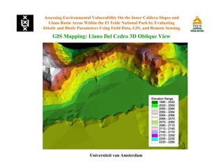
This document discusses assessing environmental vulnerability in the El Teide National Park in Tenerife, Spain. Field data, GIS mapping, and remote sensing are used to evaluate abiotic and biotic parameters on the inner caldera slopes and Llano Basin areas. Specific GIS maps of the Llano Del Cedro area are presented in both 2D and 3D views to assess environmental vulnerability.
The Perils and Promise of Environmental Data ScienceDawn Wright
Keynote address delivered in April 2019 to the Yale School of Forestry & Environmental Studies, during their annual research conference. "The mission of the Annual F&ES Research Conference is to provide a forum for research degree students and postdocs to share their original work with the F&ES community, as well as with the broader Yale and New Haven communities. After the success of last year's partnership with Yale Pathways to Science, we will again open conference attendance to local high school students and host events emphasizing research communication. Our aim is for the conference to facilitate interdisciplinary communication and collaboration both within the School and beyond the walls of Kroon."
1. Assessing Environmental Vulnerability On the Inner Caldera Slopes and
Llano Basin Areas Within the El Teide National Park by Evaluating
Abiotic and Biotic Parameters Using Field Data, GIS, and Remote Sensing.
GIS Mapping: Llano Del Cedro 3D Oblique View
Universiteit van Amsterdam
2. Assessing Environmental Vulnerability On the Inner Caldera Slopes and
Llano Basin Areas Within the El Teide National Park by Evaluating
Abiotic and Biotic Parameters Using Field Data, GIS, and Remote Sensing.
GIS Mapping: Llano Del Cedro ArcScene
Universiteit van Amsterdam