City of Canada Bay LEP Grid 2 Maps
•
0 likes•257 views

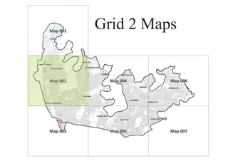
The document appears to be a map with various zones and classifications. It includes zones labeled B1 through B7 that relate to land use types like neighbourhood centers, commercial cores, and business parks. It also includes classifications like SP2 and RE1 that likely indicate types of roads and other areas. Various streets and other landmarks are labeled on the map across the different zones.
Report
Share
Report
Share
Download to read offline

Recommended
Maquinghen arnaud ukraine
The document discusses the historic events and problems in Ukraine, including Ukraine refusing to join the EU in November 2013 which led to violent riots, the government promising gas discounts and $15 billion from Russia in December, and the prime minister resigning in January in an attempt to find a peaceful solution. It also mentions torture, disappearances, Russian influence, and how outcomes could be good for Ukraine and EU but bad for Russia.
Social Networking (UA Campus Communicators)
This document discusses current trends in social networking and social media. It defines key terms like social networks, social media, and social applications. It then examines how current students use social networking sites and text messaging extensively. The document explores how social media tools can be incorporated into classrooms to improve learning outcomes through blogs, wikis, YouTube, and podcasting. It also looks at how professionals are using social media platforms like Twitter, LinkedIn, and Google Apps for collaboration in the workplace. Finally, it outlines predictions for future growth in mobile messaging and smartphone usage among youth.
First steps in applying clil
The document summarizes an attempt to teach geography content about the solar system to 6th grade students through English using Content and Language Integrated Learning (CLIL). The teacher considered factors like language level and prepared materials incorporating activities to develop the four skills and vocabulary through topics like planets, adjectives, and grammar. Students engaged with content through games, presentations, role-plays and used English to learn. Most students found it motivating and remembered information, though preparation was time-consuming and some struggled with comprehension.
T06_LM3: Estruturas de decisão em Javascript (2013-2014)
Este documento discute como tomar decisões no JavaScript usando estruturas condicionais como if/else e switch. Ele explica como usar if, if/else, else if e switch para executar instruções diferentes com base em condições e valores de variáveis.
2007 detecção de plasmodium em bancos de sangue
This study evaluated the frequency of asymptomatic Plasmodium carriers (APCs) among blood donors in four blood banks in the Brazilian Amazon region. Blood samples from 400 donors who passed screening were tested using PCR to detect Plasmodium DNA. The positivity rate varied from 1-3% between blood banks, with an overall rate of 2.3%. All positive samples contained mixed infections of P. vivax and P. falciparum. While screening methods used by the blood banks did not detect the infections, PCR revealed its superiority for detecting low levels of parasites. The results emphasize the need to improve screening for APCs in blood banks in malaria endemic areas to control transfusion-transmitted malaria.
Example of lesson plan for lesson study
Murid belajar tentang faktor-faktor yang mempengaruhi kekuatan dan kestabilan struktur dengan melakukan eksperimen sederhana dan membina model kerusi menggunakan suratkhabar. Mereka kemudiannya menguji model kerusi antara kelompok untuk mengenal pasti struktur yang paling kuat.
How to make dvd final version
O documento descreve o processo de criação de uma capa de DVD no Photoshop, incluindo adicionar um template, editar uma foto de fundo, adicionar imagens e texto. A autora explica como posicionar elementos na capa e editá-los para criar uma capa atraente para o público-alvo.
Europan 2011 Amstel III
VivAmstel 3 is a new neighborhood being developed in Amsterdam that aims to be a healthy, diverse, and socially connected community. The development will occur gradually over time through cooperation between stakeholders, with an evolution planned out until 2040. All necessary resources are being provided to stakeholders to efficiently work together on establishing amenities like sports, activities, green spaces, and infrastructure to encourage walking, cycling, and an active lifestyle.
825 howard
A 7,240 square foot retail space is available for lease at 825 Howard Street in San Francisco. The space is ideally suited for a restaurant near the Moscone Convention Center and Westfield San Francisco shopping center. It has approximately 48 feet of frontage along a busy intersection with visibility from a 40-foot blade sign.
Cas the pov
The document discusses the need to update existing typologies and design patterns to account for complex adaptive systems. It notes that the high-growth era of industrialism is ending, and current typologies set within a finite machine model are no longer effective or sustainable. It argues that typologies must be deconstructed and reconstituted as complex adaptive systems that allow for rapid feedback and adaptation. Doing so will provide opportunities for leadership by those who can develop processes and templates for implementing new complex and sustainable typologies.
City of Canada Bay LEP Grid 4 Maps
This document is a land zoning map for Canada Bay Local Environmental Plan 2011. It shows the zoning designations for different areas, including zones for neighborhood center, residential, recreation, and others. Key roads and the Parramatta River are also shown on the map. The map is labeled as Sheet LZN_004.
Competitive intelligence a selective resource guide - updated and revised j...
Competitive intelligence a selective resource guide - updated and revised j...Errol A. Adams, J.D., M.L.S.
This document provides a selective resource guide for competitive intelligence that was updated in July 2011. It lists and provides links to various web search tools, blogs, news services, video search tools, and alert services that can be used to monitor competitors and gather competitive intelligence online. Some of the tools highlighted include Google, Bing, Yahoo, LexisNexis, Factiva, Cision, and various RSS feed services.
[/SUMMARY]Plano puyo pastaza
The document lists several street names without numbers, including Calle Guayaquil, Calle Quito, Calle RioBamba, Calle Tena, Pasaje S/N, Calle S/N, and Calle A. It seems to be providing an inventory of street names in a particular area, though no other context is given.
Venue 2 Claims Management
The document contains a series of symbols and special characters with no discernible meaning. It does not provide any essential information that can be summarized in 3 sentences or less.
Park Design
Rotary Plaza is a proposed community plaza for Howard County Community College. The plaza will feature native shade trees and plantings that blend the space with the surrounding woods. An 8-foot winding path leads around the plaza with various seating options along the way, including an 18-inch tall stone seat wall and benches. The plaza is designed to provide an accessible outdoor space for visitors with walking paths, seating areas, and native landscaping.
CAR Email 6.4.02 (s)
The document discusses a new product called the XT-2000. It has several key features including a large high-resolution touchscreen display, powerful processors, and advanced cameras. The XT-2000 is a state-of-the-art mobile device that combines high performance hardware with intuitive software interfaces. It is positioned as a device that can be used for both work and entertainment purposes.
Social networking
The document discusses the impact of social networking on society and culture. It examines how people create online identities and form relationships through social media. Some key points made include that social networks have become a major communication tool, information shared through networks is trusted more than non-vetted online sources, and that social media may help reduce loneliness by maintaining existing offline relationships. Both opportunities and risks of increased social networking are considered.
Compost Modern, 2009
The document discusses climate change and energy consumption. It provides examples of how much power is needed for different daily activities, like drinking an energy drink or using electricity. It then explains that by adding up yearly, monthly, and daily energy use, one can calculate their overall lifestyle power consumption in watts, similar to the number of light bulbs that would need to be on constantly.
Hfx Dart South East
This map shows the proposed community health board boundaries for Nova Scotia. The province is divided into 13 community health boards, with boundaries following municipal and geographical lines. Major cities like Halifax and Dartmouth have their own community health boards, while more rural areas are grouped into larger regional community health boards. The map labels all communities, water features, roads, hospitals and other important landmarks to help identify the new community health board structure for Nova Scotia.
Map of St-Avila
This document provides a map showing dissemination areas, census tracts, and other geographic boundaries in Winnipeg, Manitoba, Canada. There are over 30 labeled roads and neighborhoods shown. The map covers an area of approximately 13 square kilometers at a scale of 1:13,200. Key features labeled include the Red River, various lakes, and major intersections.
Marketing Material - non-profit
The document does not contain any substantive information. It consists of blank lines and paragraph breaks without any text content.
Europes environment assessment_of_assessments
¿Qué sabemos del agua y la economía verde?.- la Agencia Europea del Medio Ambiente (AEMA) publicará un innovador informe conocido como Evaluación de Evaluaciones, que recomienda medidas para que la información y la elaboración de las políticas medioambientales estén más estrechamente alineadas.
Peptide synthesis Service - LifeTein
This document provides information about peptide synthesis company LifeTein. It discusses how LifeTein takes a scientific approach to understand life one protein at a time through peptide synthesis. Their goal is to provide researchers with the highest quality peptides to advance scientific understanding. The flyer invites readers to visit their website for more details.
выставка игрушек Hong kong toys & games fair 2012
Отдых и бизнес-тур в Китае. Посетите 39-ю Выставку игр и игрушек в Гонконге (Hong Kong Toys & Games Fair 2012)
Cv S.Uiterwijk
This document discusses a complex network of relationships between various groups and individuals. It maps connections between entities using symbols like nodes and edges. The network appears decentralized and interconnected with many indirect relationships in addition to direct connections. Interpreting the meanings and motivations between the different elements would require more context beyond what is provided in this high-level overview.
Mapa vial del departamento de Apurímac
This map shows key transportation routes and locations in the Apurimac region of Peru, including roads, rivers, and towns. Some of the labeled locations include Pulcoy, Simpi, Inca Huasi, Mara, San Jose, and the Choquequirao ruins. The map provides an overview of the transportation infrastructure and geography of the region.
Mapa vial del departamento de Huancavelica
This map shows the road network in the Huancavelica region of Peru. The key roads include the routes connecting Huancavelica to Jatun Pata, Sallapata, and Trinca, as well as the road passing through Nabra Acopalka. The map provides information on Peru's road infrastructure for transportation and communication purposes.
Presentation of the OECD Artificial Intelligence Review of Germany
Consult the full report at https://www.oecd.org/digital/oecd-artificial-intelligence-review-of-germany-609808d6-en.htm
Driving Business Innovation: Latest Generative AI Advancements & Success Story
Are you ready to revolutionize how you handle data? Join us for a webinar where we’ll bring you up to speed with the latest advancements in Generative AI technology and discover how leveraging FME with tools from giants like Google Gemini, Amazon, and Microsoft OpenAI can supercharge your workflow efficiency.
During the hour, we’ll take you through:
Guest Speaker Segment with Hannah Barrington: Dive into the world of dynamic real estate marketing with Hannah, the Marketing Manager at Workspace Group. Hear firsthand how their team generates engaging descriptions for thousands of office units by integrating diverse data sources—from PDF floorplans to web pages—using FME transformers, like OpenAIVisionConnector and AnthropicVisionConnector. This use case will show you how GenAI can streamline content creation for marketing across the board.
Ollama Use Case: Learn how Scenario Specialist Dmitri Bagh has utilized Ollama within FME to input data, create custom models, and enhance security protocols. This segment will include demos to illustrate the full capabilities of FME in AI-driven processes.
Custom AI Models: Discover how to leverage FME to build personalized AI models using your data. Whether it’s populating a model with local data for added security or integrating public AI tools, find out how FME facilitates a versatile and secure approach to AI.
We’ll wrap up with a live Q&A session where you can engage with our experts on your specific use cases, and learn more about optimizing your data workflows with AI.
This webinar is ideal for professionals seeking to harness the power of AI within their data management systems while ensuring high levels of customization and security. Whether you're a novice or an expert, gain actionable insights and strategies to elevate your data processes. Join us to see how FME and AI can revolutionize how you work with data!
More Related Content
Similar to City of Canada Bay LEP Grid 2 Maps
825 howard
A 7,240 square foot retail space is available for lease at 825 Howard Street in San Francisco. The space is ideally suited for a restaurant near the Moscone Convention Center and Westfield San Francisco shopping center. It has approximately 48 feet of frontage along a busy intersection with visibility from a 40-foot blade sign.
Cas the pov
The document discusses the need to update existing typologies and design patterns to account for complex adaptive systems. It notes that the high-growth era of industrialism is ending, and current typologies set within a finite machine model are no longer effective or sustainable. It argues that typologies must be deconstructed and reconstituted as complex adaptive systems that allow for rapid feedback and adaptation. Doing so will provide opportunities for leadership by those who can develop processes and templates for implementing new complex and sustainable typologies.
City of Canada Bay LEP Grid 4 Maps
This document is a land zoning map for Canada Bay Local Environmental Plan 2011. It shows the zoning designations for different areas, including zones for neighborhood center, residential, recreation, and others. Key roads and the Parramatta River are also shown on the map. The map is labeled as Sheet LZN_004.
Competitive intelligence a selective resource guide - updated and revised j...
Competitive intelligence a selective resource guide - updated and revised j...Errol A. Adams, J.D., M.L.S.
This document provides a selective resource guide for competitive intelligence that was updated in July 2011. It lists and provides links to various web search tools, blogs, news services, video search tools, and alert services that can be used to monitor competitors and gather competitive intelligence online. Some of the tools highlighted include Google, Bing, Yahoo, LexisNexis, Factiva, Cision, and various RSS feed services.
[/SUMMARY]Plano puyo pastaza
The document lists several street names without numbers, including Calle Guayaquil, Calle Quito, Calle RioBamba, Calle Tena, Pasaje S/N, Calle S/N, and Calle A. It seems to be providing an inventory of street names in a particular area, though no other context is given.
Venue 2 Claims Management
The document contains a series of symbols and special characters with no discernible meaning. It does not provide any essential information that can be summarized in 3 sentences or less.
Park Design
Rotary Plaza is a proposed community plaza for Howard County Community College. The plaza will feature native shade trees and plantings that blend the space with the surrounding woods. An 8-foot winding path leads around the plaza with various seating options along the way, including an 18-inch tall stone seat wall and benches. The plaza is designed to provide an accessible outdoor space for visitors with walking paths, seating areas, and native landscaping.
CAR Email 6.4.02 (s)
The document discusses a new product called the XT-2000. It has several key features including a large high-resolution touchscreen display, powerful processors, and advanced cameras. The XT-2000 is a state-of-the-art mobile device that combines high performance hardware with intuitive software interfaces. It is positioned as a device that can be used for both work and entertainment purposes.
Social networking
The document discusses the impact of social networking on society and culture. It examines how people create online identities and form relationships through social media. Some key points made include that social networks have become a major communication tool, information shared through networks is trusted more than non-vetted online sources, and that social media may help reduce loneliness by maintaining existing offline relationships. Both opportunities and risks of increased social networking are considered.
Compost Modern, 2009
The document discusses climate change and energy consumption. It provides examples of how much power is needed for different daily activities, like drinking an energy drink or using electricity. It then explains that by adding up yearly, monthly, and daily energy use, one can calculate their overall lifestyle power consumption in watts, similar to the number of light bulbs that would need to be on constantly.
Hfx Dart South East
This map shows the proposed community health board boundaries for Nova Scotia. The province is divided into 13 community health boards, with boundaries following municipal and geographical lines. Major cities like Halifax and Dartmouth have their own community health boards, while more rural areas are grouped into larger regional community health boards. The map labels all communities, water features, roads, hospitals and other important landmarks to help identify the new community health board structure for Nova Scotia.
Map of St-Avila
This document provides a map showing dissemination areas, census tracts, and other geographic boundaries in Winnipeg, Manitoba, Canada. There are over 30 labeled roads and neighborhoods shown. The map covers an area of approximately 13 square kilometers at a scale of 1:13,200. Key features labeled include the Red River, various lakes, and major intersections.
Marketing Material - non-profit
The document does not contain any substantive information. It consists of blank lines and paragraph breaks without any text content.
Europes environment assessment_of_assessments
¿Qué sabemos del agua y la economía verde?.- la Agencia Europea del Medio Ambiente (AEMA) publicará un innovador informe conocido como Evaluación de Evaluaciones, que recomienda medidas para que la información y la elaboración de las políticas medioambientales estén más estrechamente alineadas.
Peptide synthesis Service - LifeTein
This document provides information about peptide synthesis company LifeTein. It discusses how LifeTein takes a scientific approach to understand life one protein at a time through peptide synthesis. Their goal is to provide researchers with the highest quality peptides to advance scientific understanding. The flyer invites readers to visit their website for more details.
выставка игрушек Hong kong toys & games fair 2012
Отдых и бизнес-тур в Китае. Посетите 39-ю Выставку игр и игрушек в Гонконге (Hong Kong Toys & Games Fair 2012)
Cv S.Uiterwijk
This document discusses a complex network of relationships between various groups and individuals. It maps connections between entities using symbols like nodes and edges. The network appears decentralized and interconnected with many indirect relationships in addition to direct connections. Interpreting the meanings and motivations between the different elements would require more context beyond what is provided in this high-level overview.
Mapa vial del departamento de Apurímac
This map shows key transportation routes and locations in the Apurimac region of Peru, including roads, rivers, and towns. Some of the labeled locations include Pulcoy, Simpi, Inca Huasi, Mara, San Jose, and the Choquequirao ruins. The map provides an overview of the transportation infrastructure and geography of the region.
Mapa vial del departamento de Huancavelica
This map shows the road network in the Huancavelica region of Peru. The key roads include the routes connecting Huancavelica to Jatun Pata, Sallapata, and Trinca, as well as the road passing through Nabra Acopalka. The map provides information on Peru's road infrastructure for transportation and communication purposes.
Similar to City of Canada Bay LEP Grid 2 Maps (20)
Competitive intelligence a selective resource guide - updated and revised j...
Competitive intelligence a selective resource guide - updated and revised j...
Recently uploaded
Presentation of the OECD Artificial Intelligence Review of Germany
Consult the full report at https://www.oecd.org/digital/oecd-artificial-intelligence-review-of-germany-609808d6-en.htm
Driving Business Innovation: Latest Generative AI Advancements & Success Story
Are you ready to revolutionize how you handle data? Join us for a webinar where we’ll bring you up to speed with the latest advancements in Generative AI technology and discover how leveraging FME with tools from giants like Google Gemini, Amazon, and Microsoft OpenAI can supercharge your workflow efficiency.
During the hour, we’ll take you through:
Guest Speaker Segment with Hannah Barrington: Dive into the world of dynamic real estate marketing with Hannah, the Marketing Manager at Workspace Group. Hear firsthand how their team generates engaging descriptions for thousands of office units by integrating diverse data sources—from PDF floorplans to web pages—using FME transformers, like OpenAIVisionConnector and AnthropicVisionConnector. This use case will show you how GenAI can streamline content creation for marketing across the board.
Ollama Use Case: Learn how Scenario Specialist Dmitri Bagh has utilized Ollama within FME to input data, create custom models, and enhance security protocols. This segment will include demos to illustrate the full capabilities of FME in AI-driven processes.
Custom AI Models: Discover how to leverage FME to build personalized AI models using your data. Whether it’s populating a model with local data for added security or integrating public AI tools, find out how FME facilitates a versatile and secure approach to AI.
We’ll wrap up with a live Q&A session where you can engage with our experts on your specific use cases, and learn more about optimizing your data workflows with AI.
This webinar is ideal for professionals seeking to harness the power of AI within their data management systems while ensuring high levels of customization and security. Whether you're a novice or an expert, gain actionable insights and strategies to elevate your data processes. Join us to see how FME and AI can revolutionize how you work with data!
みなさんこんにちはこれ何文字まで入るの?40文字以下不可とか本当に意味わからないけどこれ限界文字数書いてないからマジでやばい文字数いけるんじゃないの?えこ...
ここ3000字までしか入らないけどタイトルの方がたくさん文字入ると思います。
Main news related to the CCS TSI 2023 (2023/1695)
An English 🇬🇧 translation of a presentation to the speech I gave about the main changes brought by CCS TSI 2023 at the biggest Czech conference on Communications and signalling systems on Railways, which was held in Clarion Hotel Olomouc from 7th to 9th November 2023 (konferenceszt.cz). Attended by around 500 participants and 200 on-line followers.
The original Czech 🇨🇿 version of the presentation can be found here: https://www.slideshare.net/slideshow/hlavni-novinky-souvisejici-s-ccs-tsi-2023-2023-1695/269688092 .
The videorecording (in Czech) from the presentation is available here: https://youtu.be/WzjJWm4IyPk?si=SImb06tuXGb30BEH .
Let's Integrate MuleSoft RPA, COMPOSER, APM with AWS IDP along with Slack
Discover the seamless integration of RPA (Robotic Process Automation), COMPOSER, and APM with AWS IDP enhanced with Slack notifications. Explore how these technologies converge to streamline workflows, optimize performance, and ensure secure access, all while leveraging the power of AWS IDP and real-time communication via Slack notifications.
Generating privacy-protected synthetic data using Secludy and Milvus
During this demo, the founders of Secludy will demonstrate how their system utilizes Milvus to store and manipulate embeddings for generating privacy-protected synthetic data. Their approach not only maintains the confidentiality of the original data but also enhances the utility and scalability of LLMs under privacy constraints. Attendees, including machine learning engineers, data scientists, and data managers, will witness first-hand how Secludy's integration with Milvus empowers organizations to harness the power of LLMs securely and efficiently.
June Patch Tuesday
Ivanti’s Patch Tuesday breakdown goes beyond patching your applications and brings you the intelligence and guidance needed to prioritize where to focus your attention first. Catch early analysis on our Ivanti blog, then join industry expert Chris Goettl for the Patch Tuesday Webinar Event. There we’ll do a deep dive into each of the bulletins and give guidance on the risks associated with the newly-identified vulnerabilities.
Ocean lotus Threat actors project by John Sitima 2024 (1).pptx
Ocean Lotus cyber threat actors represent a sophisticated, persistent, and politically motivated group that poses a significant risk to organizations and individuals in the Southeast Asian region. Their continuous evolution and adaptability underscore the need for robust cybersecurity measures and international cooperation to identify and mitigate the threats posed by such advanced persistent threat groups.
GraphRAG for Life Science to increase LLM accuracy
GraphRAG for life science domain, where you retriever information from biomedical knowledge graphs using LLMs to increase the accuracy and performance of generated answers
Best 20 SEO Techniques To Improve Website Visibility In SERP
Boost your website's visibility with proven SEO techniques! Our latest blog dives into essential strategies to enhance your online presence, increase traffic, and rank higher on search engines. From keyword optimization to quality content creation, learn how to make your site stand out in the crowded digital landscape. Discover actionable tips and expert insights to elevate your SEO game.
Columbus Data & Analytics Wednesdays - June 2024
Columbus Data & Analytics Wednesdays, June 2024 with Maria Copot 20
OpenID AuthZEN Interop Read Out - Authorization
During Identiverse 2024 and EIC 2024, members of the OpenID AuthZEN WG got together and demoed their authorization endpoints conforming to the AuthZEN API
Building Production Ready Search Pipelines with Spark and Milvus
Spark is the widely used ETL tool for processing, indexing and ingesting data to serving stack for search. Milvus is the production-ready open-source vector database. In this talk we will show how to use Spark to process unstructured data to extract vector representations, and push the vectors to Milvus vector database for search serving.
How to Interpret Trends in the Kalyan Rajdhani Mix Chart.pdf
A Mix Chart displays historical data of numbers in a graphical or tabular form. The Kalyan Rajdhani Mix Chart specifically shows the results of a sequence of numbers over different periods.
20240609 QFM020 Irresponsible AI Reading List May 2024
Everything I found interesting about the irresponsible use of machine intelligence in May 2024
Artificial Intelligence for XMLDevelopment
In the rapidly evolving landscape of technologies, XML continues to play a vital role in structuring, storing, and transporting data across diverse systems. The recent advancements in artificial intelligence (AI) present new methodologies for enhancing XML development workflows, introducing efficiency, automation, and intelligent capabilities. This presentation will outline the scope and perspective of utilizing AI in XML development. The potential benefits and the possible pitfalls will be highlighted, providing a balanced view of the subject.
We will explore the capabilities of AI in understanding XML markup languages and autonomously creating structured XML content. Additionally, we will examine the capacity of AI to enrich plain text with appropriate XML markup. Practical examples and methodological guidelines will be provided to elucidate how AI can be effectively prompted to interpret and generate accurate XML markup.
Further emphasis will be placed on the role of AI in developing XSLT, or schemas such as XSD and Schematron. We will address the techniques and strategies adopted to create prompts for generating code, explaining code, or refactoring the code, and the results achieved.
The discussion will extend to how AI can be used to transform XML content. In particular, the focus will be on the use of AI XPath extension functions in XSLT, Schematron, Schematron Quick Fixes, or for XML content refactoring.
The presentation aims to deliver a comprehensive overview of AI usage in XML development, providing attendees with the necessary knowledge to make informed decisions. Whether you’re at the early stages of adopting AI or considering integrating it in advanced XML development, this presentation will cover all levels of expertise.
By highlighting the potential advantages and challenges of integrating AI with XML development tools and languages, the presentation seeks to inspire thoughtful conversation around the future of XML development. We’ll not only delve into the technical aspects of AI-powered XML development but also discuss practical implications and possible future directions.
HCL Notes and Domino License Cost Reduction in the World of DLAU
Webinar Recording: https://www.panagenda.com/webinars/hcl-notes-and-domino-license-cost-reduction-in-the-world-of-dlau/
The introduction of DLAU and the CCB & CCX licensing model caused quite a stir in the HCL community. As a Notes and Domino customer, you may have faced challenges with unexpected user counts and license costs. You probably have questions on how this new licensing approach works and how to benefit from it. Most importantly, you likely have budget constraints and want to save money where possible. Don’t worry, we can help with all of this!
We’ll show you how to fix common misconfigurations that cause higher-than-expected user counts, and how to identify accounts which you can deactivate to save money. There are also frequent patterns that can cause unnecessary cost, like using a person document instead of a mail-in for shared mailboxes. We’ll provide examples and solutions for those as well. And naturally we’ll explain the new licensing model.
Join HCL Ambassador Marc Thomas in this webinar with a special guest appearance from Franz Walder. It will give you the tools and know-how to stay on top of what is going on with Domino licensing. You will be able lower your cost through an optimized configuration and keep it low going forward.
These topics will be covered
- Reducing license cost by finding and fixing misconfigurations and superfluous accounts
- How do CCB and CCX licenses really work?
- Understanding the DLAU tool and how to best utilize it
- Tips for common problem areas, like team mailboxes, functional/test users, etc
- Practical examples and best practices to implement right away
Skybuffer SAM4U tool for SAP license adoption
Manage and optimize your license adoption and consumption with SAM4U, an SAP free customer software asset management tool.
SAM4U, an SAP complimentary software asset management tool for customers, delivers a detailed and well-structured overview of license inventory and usage with a user-friendly interface. We offer a hosted, cost-effective, and performance-optimized SAM4U setup in the Skybuffer Cloud environment. You retain ownership of the system and data, while we manage the ABAP 7.58 infrastructure, ensuring fixed Total Cost of Ownership (TCO) and exceptional services through the SAP Fiori interface.
Recently uploaded (20)
Presentation of the OECD Artificial Intelligence Review of Germany
Presentation of the OECD Artificial Intelligence Review of Germany
Driving Business Innovation: Latest Generative AI Advancements & Success Story
Driving Business Innovation: Latest Generative AI Advancements & Success Story
みなさんこんにちはこれ何文字まで入るの?40文字以下不可とか本当に意味わからないけどこれ限界文字数書いてないからマジでやばい文字数いけるんじゃないの?えこ...
みなさんこんにちはこれ何文字まで入るの?40文字以下不可とか本当に意味わからないけどこれ限界文字数書いてないからマジでやばい文字数いけるんじゃないの?えこ...
Let's Integrate MuleSoft RPA, COMPOSER, APM with AWS IDP along with Slack
Let's Integrate MuleSoft RPA, COMPOSER, APM with AWS IDP along with Slack
Generating privacy-protected synthetic data using Secludy and Milvus
Generating privacy-protected synthetic data using Secludy and Milvus
Ocean lotus Threat actors project by John Sitima 2024 (1).pptx
Ocean lotus Threat actors project by John Sitima 2024 (1).pptx
WeTestAthens: Postman's AI & Automation Techniques
WeTestAthens: Postman's AI & Automation Techniques
GraphRAG for Life Science to increase LLM accuracy
GraphRAG for Life Science to increase LLM accuracy
Best 20 SEO Techniques To Improve Website Visibility In SERP
Best 20 SEO Techniques To Improve Website Visibility In SERP
Building Production Ready Search Pipelines with Spark and Milvus
Building Production Ready Search Pipelines with Spark and Milvus
How to Interpret Trends in the Kalyan Rajdhani Mix Chart.pdf
How to Interpret Trends in the Kalyan Rajdhani Mix Chart.pdf
20240609 QFM020 Irresponsible AI Reading List May 2024
20240609 QFM020 Irresponsible AI Reading List May 2024
HCL Notes and Domino License Cost Reduction in the World of DLAU
HCL Notes and Domino License Cost Reduction in the World of DLAU
City of Canada Bay LEP Grid 2 Maps
- 1. Grid 2 Maps