Report
Share
Download to read offline
Recommended
Site Analysis
The document discusses site analysis for building design. Site analysis is the process of studying the existing environment and how it will influence a structure's design and layout. Key factors in site analysis include topography, vegetation, soil, climate, sunlight, and regulatory considerations. Contour lines are used to represent the topography and slope of the land, which greatly impacts building design. A thorough site analysis must be completed before beginning the design process.
Reservoir planning ajitha miss
Reservoirs are created by retaining excess water from periods of high flow to be used during low flow periods. Their purposes include irrigation, hydroelectric power, and water supply. Planning a reservoir involves engineering surveys to determine storage capacity and area, geological investigations to evaluate the foundation and basin, and hydrological investigations to study runoff patterns and floods. Key considerations in reservoir site selection include suitable dam location, minimum submerged land, avoiding high sediment rivers, and maximizing storage capacity. Reservoirs have zones like normal pool level, minimum pool level, and maximum pool level. Yield depends on inflow and storage changes. Mass and demand curves help determine required reservoir capacity and safe yield.
Roof notes
The document discusses different types of roof membranes, including built-up roof (BUR) membranes made of multiple felts and asphalt layers, modified bitumen roof (MBR) membranes made of polymer-modified asphalt sheets, and single-ply roof (SPR) membranes made of synthetic polymer sheets. It also describes some common polymers used in modified bitumen membranes like SBS and APP and materials used in felts like organic fibers, glass fibers, and asphalt or coal tar coatings. Finally, it mentions two common types of single-ply membranes - EPDM, a synthetic rubber membrane, and PVC or TPO thermoplastic membranes.
Lecture 1 site analysis
The document discusses the importance of site analysis for building design. Site analysis is the process of studying the existing environment and how it will influence a structure's design and layout. Key factors to consider in site analysis include topography, vegetation, climate, views, and regulatory requirements. Contour lines are used to represent the topography and slope of land, which greatly impacts building foundation and drainage design. Conducting a thorough site analysis is essential before beginning the design process.
Site planning by kevin lynch
The document discusses site planning and analysis of natural factors for site selection. It describes analyzing a site's geology, geomorphology, hydrology, vegetation, wildlife and climate. Key aspects of the natural analysis include examining a site's topography and slopes through tools like contour maps and slope maps. These maps are used to understand drainage, soil composition and erosion potential, which influence what land uses are suitable for different slopes. Performing a thorough natural analysis of a site is important for making informed planning decisions around development suitability and layout.
IB Geography: Globalization: Tourism: Resort Life Cycle Model
The document describes the typical life cycle model of a tourist resort, which progresses through phases from exploration to decline. In the exploration phase, small numbers of visitors are attracted by natural beauty and few facilities exist. Involvement follows as locals provide some tourist facilities and a season emerges. Development occurs as large visitor numbers arrive and control shifts to organizations. Consolidation happens when tourism becomes a major economy, numbers level off, and older facilities age. Stagnation is reached at peak numbers and decreased fashionability. Decline ensues as attractiveness and visitors decline, relying on local day visitors unless rejuvenation actions are taken.
Contouring
The document provides information on contouring and contour maps. It defines a contour as an imaginary line joining points of equal elevation. Contour maps show contour lines and provide information on surface altitudes and relative positions. The process of tracing contour lines is called contouring. Contour surveys are conducted for engineering projects to select sites, locate alignments, and minimize earthworks. The constant vertical distance between contours is the contour interval, while the horizontal distance varies based on slope. Contour interpolation involves proportionally spacing contours between plotted ground points based on assumed uniform slopes.
resort casestudy
This document summarizes a case study report for the Wind Flower Spa & Resorts project in Vythiri, Kerala. The 25-acre resort located on a hilltop features pitched roof villas and suites, as well as spa, pool, and restaurant facilities arranged in a linear site plan to take advantage of views of the surrounding hills. While the design utilizes local materials and separates public, private, and service areas appropriately, it could improve utilization of space and provide more recreational amenities and security.
More Related Content
More from bvald005
More from bvald005 (12)
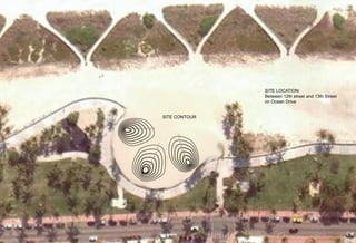
Site contour
- 1. SITE LOCATION: Between 12th street and 13th Street on Ocean Drive SITE CONTOUR 7’ 6’ 5’ 4’ 3’ 2’ 1’ 1’ 2’ 3’ 1’ 4’ 2’ 5’ 3’ 6’ 4’ 7’ 5’ 6’ 7’