Settlement Map Questions
•Download as PPT, PDF•
0 likes•427 views

The document provides instructions for analyzing and comparing different urban environments and residential areas based on map evidence. It prompts the reader to look for features like land use, industry, housing patterns, open spaces, and street grids to describe the differences between model areas, a commuter belt versus modern housing development, and specific places like Nunthorpe versus Linthorpe/Marton Grove, Denniston versus Castlemilk, and residential areas in Coatbridge and Sunnyside. The reader is asked to specifically refer to map evidence in their analyses and descriptions.

More Related Content
Viewers also liked
Viewers also liked (19)
More from jdmcd
More from jdmcd (20)
Recently uploaded
Recently uploaded (20)
Settlement Map Questions
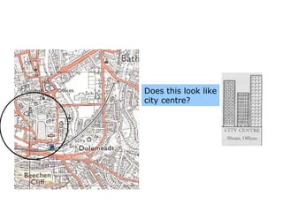
- 1. Does this look like city centre?
- 2. Describe the differences in land use between the model and those found along the transect. 4 marks Careful this is a 1:25 000 map You should be thinking of what the different above areas SHOULD look like on the map
- 3. Evidence of old factories and housing? Where is all the industry? Any grid iron housing? Open spaces?
- 4. Commuter belt/ Modern housing? Does this look like modern housing? Open space? Modern Industrial Estates?
- 5. Describe the differences between the two urban environments of Nunthorpe and Linthorpe/Marton Grove 5 marks What four features have been pointed out? What does this tell you about the area you are looking at? NOW DESCRIBE Remember to use phrases such as unlike, similar to…
- 6. Using map evidence, describe the differences between these two areas. 4 marks
- 8. Give map evidence to show that the CBD of Motherwell is in the Grid below 3 marks
- 9. Describe the differences between the two residential areas of Coatbridge and Sunnyside. You must refer to map evidence. 4 marks