Chapple, R. M. 2013 Iverni: a prehistory of Cork | Review. Blogspot postRobert M Chapple
This document provides a review of a two-volume book titled "Iverni: a prehistory of Cork" by William O'Brien. The reviewer summarizes several chapters of the book in detail, highlighting how it brings together recent archaeological evidence from developments and excavations to provide insights into the Stone Age, Bronze Age, and ritual practices in Cork, Ireland. The reviewer praises how the book synthesizes new findings to shed light on the region's prehistory for specialist and general readers alike. Some points of archaeological debate around site interpretations are also discussed.
Chapple, R. M. 2014 Archaeology of Gatherings Conference | Institute of Techn...Robert M Chapple
The document summarizes the Archaeology of Gatherings Conference that took place in Sligo, Ireland in October 2013. The conference brought together academics from various disciplines to discuss gatherings. It describes several of the presentations in detail, including talks on defining ritual and social cohesion, football as a social drama, the role of railways in facilitating gatherings in Ireland, and crowd-sourcing in the construction of Neolithic passage tombs. The conference aimed to stimulate new perspectives and research on identifying and understanding large-scale social and religious gatherings in the archaeological record. It appeared to be well-attended and received, with the hope that selected papers may be published in the future.
Chapple, R. M. 2014 Archaeology of Gatherings Conference | Institute of Techn...Robert M Chapple
This document summarizes several presentations from the "Archaeology of Gatherings Conference" held in Sligo, Ireland in October 2013. The first presentation discussed medieval assembly places called Óenach sites in Ireland and how shifts in territorial boundaries could exclude groups from these important political and ritual gatherings. The second presentation examined public demonstrations and parades in Belfast as expressions of identity and power, and how the meaning and role of such gatherings has changed from the 1960s to today. The third presentation made comparisons between presentations of tribute called "Inu" in ancient Egypt and elaborate colonial durbars held by the British in India in the late 19th century, both events which brought subject peoples together but reinforced colonial ide
Chapple, R. M. 2012 'Archaeology Ireland 26.1 (Issue 99) Spring 2012. Review'...Robert M Chapple
This document provides a summary of the Spring 2012 issue of Archaeology Ireland magazine. It discusses several papers from the issue, including reports on archaeological discoveries such as a possible Celtic icon stone and a Bronze Age copper mine. It also reviews papers on topics like the origins of the Ogham alphabet and mysterious depressions found at an archaeological site in Roscommon. The summary critically analyzes the arguments and evidence presented in several of the papers.
Chapple, R. M. 2014 Appendix | Dunbeg, Co. Kerry | Radiocarbon Dating. Blogsp...Robert M Chapple
This document summarizes the results of radiocarbon dating from an excavation at Dunbeg Promontory Fort in County Kerry, Ireland. Four radiocarbon dates were obtained: one from the Late Bronze Age (2530±35 BP), and three from the Early Christian period between the 8th-11th centuries AD. While limited in number, these dates provide valuable chronological evidence given the lack of diagnostic artifacts. They indicate the site was in use from the Late Bronze Age through the Early Christian period. The author calls for further dating to better understand the site's full chronology and landscape context.
Irish National Strategic Research (INSTAR) programme findings from the first...Robert M Chapple
The document summarizes the findings presented at a one-day conference on the Irish National Strategic Research (INSTAR) Programme from 2008-2011. Several papers discussed advances in knowledge of early Christian landscapes in Ireland through interdisciplinary research combining archaeology, history and landscape analysis. Key findings included identifying the extent of early monastic estates and recognizing 'cemetery settlements' as integral parts of the early Christian landscape. Other projects discussed included analyzing Neolithic and Bronze Age landscapes in North Mayo through GIS mapping, and using GIS to integrate data on landscape evolution in the River Boyne valley, revealing over 130 new archaeological sites.
Chapple, R. M. 2012 'The archaeology of an archaeologist: a reassessment of t...Robert M Chapple
The document summarizes the author's experience excavating the contents of his old vehicle, a 1998 Nissan Terrano, using archaeological techniques and documentation methods. This "experiment" was inspired by a previous excavation of a Ford Transit van. The author provides a photographic catalogue of items recovered from the vehicle. Through reflecting on interpreting the assemblage of artifacts, the author questions how reliably the past can be interpreted and how cultural understandings can differ greatly over time. The experience highlights issues in using archaeological evidence to make assumptions about past peoples' lives and worldviews.
Chapple, r. m. 2014 dunbeg, co. kerry early christian promontory fort - dam...Robert M Chapple
The promontory fort at Dunbeg, Co. Kerry suffered significant damage during recent storms. A large portion of the western stone rampart fell into the sea. The site consists of four stone and earth banks that defended a small coastal promontory, with an inner stone-built rampart that was originally straight but later remodeled and reconstructed in a curved shape. Archaeological excavations in 1977 uncovered evidence of settlement from the Neolithic to medieval periods, including a stone house and souterrain. The damage underscores the threat that coastal erosion has long posed to this important archaeological site.
Review: Hidden History Below Our Feet: The Archaeological Story of BelfastRobert M Chapple
This book provides a concise summary of the archaeological history of Belfast from prehistoric times to the present day. It is divided into 5 chronological chapters, each beginning with a map and site inventory and exploring what archaeological excavations have revealed about settlements, burials, and material culture during that time period. Engaging illustrations bring the landscapes and sites to life. While more excavations could be published, this volume successfully synthesizes existing research into a single accessible resource. It informs both professionals and amateurs while avoiding oversimplification.
Chapple, R. M. 2011 'Was the building boom so bad for Irish archaeology? A re...Robert M Chapple
The document is a response to an article that criticized how the Irish building boom negatively impacted archaeology. The response argues that:
1) While legislation had flaws and could be improved, it was generally applied reasonably given limited resources.
2) Developers prioritized profits, but archaeology firms had to operate as businesses within that reality. More can be done to enforce developer responsibilities.
3) Stereotypes on both sides hindered relations, and archaeologists must become more professional to succeed in a business environment.
Chapple, R. M. 2012 'Bubbling over: archaeological lipid analysis and the Iri...Robert M Chapple
The document summarizes a lecture on lipid analysis of pottery from Irish Neolithic sites. The lecture discussed:
1) How lipid analysis can identify the contents of pots to learn about past diets and economies.
2) The SCHERD project aims to analyze lipids from 15 Irish Neolithic sites to identify regional patterns and chronological changes over time.
3) Preliminary results show lipids are surviving on sherds, though more analysis is still needed to confirm findings.
Review: The Dublin Region in the Middle Ages: Settlement, Land-use and EconomyRobert M Chapple
This document provides a summary of a book titled "The Dublin Region in the Middle Ages: Settlement, Land-use and Economy". The book is a major publication that is the result of the Medieval Rural Settlement Project. It constructs a picture of the medieval landscape and settlement features of Dublin city and its surrounding 30km hinterland using archaeological and documentary sources. The book is divided into three parts that examine settlement and society, patterns of land ownership and defense, the church, rural settlements, and agriculture in the region during the Middle Ages. It provides a comprehensive analysis of medieval Dublin and its surrounding area based on an extensive collection of sources.
Review: Past times, changing fortunes: proceedings of a public seminar on arc...Robert M Chapple
This document provides a summary and review of the book "Past Times, Changing Fortunes: Proceedings of a Public Seminar on Archaeological Discoveries on National Road Schemes, August 2010". The review summarizes the key findings and arguments from nine papers presented in the book. These include studies of souterrains and Viking warfare in North County Louth, the development of urban and rural settlement in medieval Cashel, County Tipperary, landscape evolution and land use in North Cork, paleoecological evidence of Bronze Age farming in County Clare, the development and decline of cereal drying kilns in medieval Kildare, insights from insect remains on human-environmental interactions, and perspectives on mortuary practices from Bron
Workingman’s Dead: notes on some 17th to 19th century memorials, from the gra...Robert M Chapple
This document provides an introduction and background information about a study of 17th-19th century gravestones from two church sites in County Galway, Ireland. It summarizes the history of the church sites at Killora and Killogilleen and the physical remains. It then describes in detail six gravestones found at the sites that depict the occupations of the deceased, including two previously documented gravestones marking blacksmiths, one of which is shown in figures with hammer, tongs and horseshoe carvings. The document aims to present some of the finest examples of post-Medieval gravestone carving found and discuss them in the context of memorial trends over time.
Stratified Desks | Stratified Minds | An archaeological Survey | 100th blog postRobert M Chapple
This document summarizes Robert Chapple's blog post about photographing archaeologists' desks as they are to provide a glimpse into their workspaces and lives. Chapple was inspired by a photo of Albert Einstein's desk taken on the day of his death. He asked archaeologists and others to photograph their desks as-is in one snapshot without cleaning up. Over 30 people from various countries responded quickly with photos of their messy, cluttered, and organized desks, giving insights into their work and personalities. Chapple compiled the photos and background information on each contributor in his survey of archaeological desks.
Chapple, R. M. 2014 Derry Churches, Co. Down. Blogspot postRobert M Chapple
The author visited the Derry Churches, two ruined churches located outside of Portaferry in County Down, Northern Ireland. The churches date back to between the 10th-12th centuries and were originally part of a bustling monastic settlement. In 1959, the site was taken into state care and partially excavated in 1962, uncovering remnants of earlier buildings and a long-cist cemetery. Ongoing conservation work is being performed to preserve the structures. The author encourages visitors to see the peaceful ruins for themselves.
Chapple, R. M. 2014 Archaeological finds & archives in the Republic of Irelan...Robert M Chapple
The document discusses the different approaches taken by the National Monuments Service in Ireland and the Northern Ireland Environment Agency to managing archaeological archives and contingencies for consultancies going out of business. The NMS proactively works with excavators to archive materials at low cost, while the NIEA has been studying solutions for years but lacks an active archive process. The editor commends the NMS's efforts but criticizes the NIEA for failing to implement concrete plans, risking the loss of Northern Ireland's archaeological heritage.
Chapple, R. M. 2014 New Adventures with High Crosses - Clogher, Co. Tyrone. B...Robert M Chapple
The document summarizes the author's visit to Clogher, Co. Tyrone in Ireland with his two sons. They stopped to see the early Christian high crosses in Clogher but found the church gates locked. A nun offered them refreshments at a nearby nursing home. A few weeks later when passing through again, the author saw the gates were open and went inside to examine the two surviving 9th-10th century crosses carved with intricate designs, as well as a possible fragment of a third cross. The author hopes to return to see more of the archaeological sites in Clogher.
Human remains of 48 individuals were discovered and excavated during works associated with the Tuam Town Water Supply Scheme in Toberjarlath townland on the eastern edges of Tuam, County Galway. The burials were located within the bounds of the former Tuam Union Workhouse, which opened in 1846. Eighteen grave pits containing between two and four burials each were uncovered. Analysis showed the individuals were paupers buried in the former workhouse grounds in the 19th century. A section of the workhouse boundary wall and internal ditch were also excavated.
Professor Carolyn Roberts - A Silent Witness: Murder and the Application of E...IES / IAQM
The bodies of murder victims, either whole or in pieces, often finish up in rivers and canals. For the last fifteen years or so, Carolyn Roberts has worked as an Expert Witness with various UK police forces to apply the principles of environmental science in murder investigations. In these most tragic and gruesome settings, environmental science can help to identify where bodies have come from, or gone to. Drawing on a number of macabre case studies, the talk will take you from the details of particular cases to the general principles of tracing bodies.
Probably not for those of a nervous disposition, but of guaranteed interest to the curious.
The excavation of the site at Gortnahown 4 revealed deposits of disturbed burnt mound material overlain by re-deposited subsoil. The layers of burnt mound material were ex situ. They may have been removed from their original location during land reclamation works. No radiocarbon date was obtained for this site.
The excavation of the site at Ballynacarriga 1 revealed a dry water course. The stream may have been diverted during construction works associated with the nearby Ballynacarriaga House. A flint flake and sherds of 18 th /19 th century pottery were recovered from the sands and gravels of the dry water course. The flint flake dates to the Neolithic period.
The excavation of Kilshanny 2 along the route of the N8 Fermoy to Mitchelstown Bypass in County Cork revealed five pits spread across two fields. Radiocarbon dating of material from the site returned a date from the Middle Bronze Age, although the pits themselves are likely to be post-medieval in date. Plant remains and charcoal were also recovered from the site and will aid in further analysis of the archaeology.
The project focuses on quantifying the effects of the limestone’s exploitation in Băița-Crăciunești Quarry on local biodiversity and its social impact. The influence of the operation extends beyond the predefined perimeter of the exploitation, having an impact on the surrounding natural and anthropic environments.
The purpose of this project was to develop a series of graphic representations from the data obtained on the field, which will highlight the exploitation’s range of influence generated from diverse sources. These maps provide an overall view of the impacted area, leading to the proposal of new methods to decrease the effects generated by the exploitation on biodiversity.
Considering that human settlements are in the nearby vicinity of the extracting operation, willing people from Băiță and Crăciunești villages will undergo a social impact study. In addition, this study will lead to a higher degree of awareness about the necessity of exploitations.
The project won the 1st Prize in National Quarry Life Award in 2014 in Romania.
Read more: http://www.quarrylifeaward.com/project/influences-non-metalliferous-ore-exploitation-biodiversity-and-its-social-impact
The excavation of the site at Kildrum revealed a fulacht fiadh with five troughs with numerous fills of burnt mound material. The actual burnt mound survived only as shallow layers truncated by a deep field boundary. Two of the troughs were large in size and showed evidence of lining as stake-holes were recorded in the base of the troughs. Early Bronze Age dates were returned from charcoal from two of the fills of the troughs. The site was truncated by a field boundary, several land drains and a modern forest plantation.
No water source is evident in the immediate surrounds of the site but running water was recorded in the base of the field boundary. Analysis of charcoal from the site suggests that almost equal amounts of hazel, oak, and alder charcoal were used in the fires at the site.
Geophysical Survey: Land Adjacent to Archaeological Sites - County Offaly & C...John Tierney
This document provides details of archaeological geophysical surveys conducted at 5 sites - Busherstown 1, Drumbaun 2, Drumroe 1, Killeisk 1, and Park 1 - located along the route of a new road scheme in Counties Offaly and Tipperary, Ireland. Magnetic gradiometer and susceptibility surveys were used to investigate the archaeological remains found during previous excavations. The surveys identified potential archaeological features extending beyond the excavation areas, including ditches, enclosures, and field boundaries, adding to the understanding of activity at these sites. The results provide valuable information to planners but require verification through archaeological excavation.
The document provides background information on a collection of over 10,000 lantern slides held by the Geographical Association. It discusses how a selection of 25 slides from the British Isles will be used in the "Geographers' Gaze" project to highlight changing landscapes. It provides brief descriptions of the first few slides, including images of Aberglaslyn Pass in Wales, a mine in the Lake District, and Borth beach in Wales. The project aims to use the historic images to engage students by comparing them with modern maps and images.
The excavation of the site at Gortore 1b E2410 comprised three areas, 1, 2 and 3. The site was located on the southern bank of the River Funshion. A truncated house and a group of pits and post-holes were excavated in Area 1. A group of pits, some dating to the Mesolithic period, were excavated in Area 2. A large concentration of pits, post-holes and hearths, which formed at least two possible structures, were excavated in Area 3. The underlying limestone geology and the formation of sink holes in Area 3 were problematic.
An important assemblage of lithic artefacts, dating from the Early Mesolithic to the Late Neolithic/Early Bronze Age, was recovered, in particular from Area 2 and Area 3. An assemblage of Early Neolithic carinated bowls and Middle Neolithic gobular bowls was also recovered from the site. A corn-drying kiln dated to the early medieval period was recorded in Area 1.
The site at Gortnahown was divided into five separate cuttings. Areas 1 and 2 comprised one cutting. Area 3 was located 80 m to the south-west. Area 4 was located 110 m south-west of Area 3 and Area 5 was located 65 m south of Area 4. Areas of activity centred on hearths were dated to the Late Neolithic/Early Bronze Age period. One of the hearth-side groups was associated with flint knapping. Two substantial roundhouses and two ancillary structures, including a workshop were dated to the early medieval period. Evidence for all phases of metalworking including the manufacture of bronze coated iron bells was recorded at the site. The area was enclosed by a ditch in the medieval or post-medieval period.
Evidence for Early Neolithic and Late Neolithic/Early Bronze Age occupation was recorded in the form of a number of pits and post-holes in Area 3. Post-medieval pits and ditches were recorded in Area 4. The truncated remains of two possible medieval houses and a number of pits were recorded in Area 5.
This interim report summarizes excavations at Penycloddiau Hillfort in Flintshire, North Wales in 2012. Two areas were excavated along the inner rampart on the eastern side. Area 1 revealed modern damage and erosion to the rampart from the 20th/21st centuries. Earlier features from the post-medieval to late Iron Age periods were also uncovered, but no intact rampart deposits. Area 2 found fragmented remains of a stone structure along the rampart crest dating to the medieval/post-medieval periods. Both areas provide insight into the hillfort's construction and use while identifying threats from modern erosion.
This was a small, porrly preserved burnt mound from which a Late Bronze Age date was returned. A shallow trough contained a number of stakeholes in the base of the pit. No finds were found. One Late Bronze Age date was returned from the basal fill of the trough.
This report details an archaeological excavation of site E2420 - Caherdrinny 1, a burnt mound located in Co. Cork. The excavation was conducted as part of an archaeological assessment for the proposed N8 Fermoy to Mitchelstown road project. The excavation of the burnt mound revealed a deposit of heat-shattered stone and charcoal, interpreted as the remains of a truncated burnt mound. No radiocarbon date was obtained for this site. The report provides background on the road project, excavation methodology and results, and discusses the site in the context of other Bronze Age sites found in the area.
Three separate cuttings were excavated at Derrybane 1. Area 1 measured 20 m by 20 m, Area 2 measured 92 m by 30 m and Area 3 measured 13 m by 15 m. Three large pits were excavated in Area 1. Area 2 was characterised by 22 small and shallow pits, located for the most part in the centre of the site, 12 postholes and three hearths. The entire area was truncated by modern drains and furrows. An Early Bronze Age date, an early medieval and a medieval date were returned from pits and a hearth in Area 2. A corn-drying kiln and associated pit were recorded in Area 3. The figure-of-eight type kiln comprised two oval chambers separated by a flue. There was evidence for three or four phases of use in the kiln. A large oval pit was located adjacent to the kiln. The pit contained large amounts of burnt material, possibly waste from the kiln. The kiln was dated to the medieval period.
The excavation of the site at Clashnevin 2 comprised a group of stake-holes, pits, post-holes and layers. The domestic activity was dated to the late Bronze Age / early Iron Age.
The two dates were returned from the fill of a pit and an occupation layer. Evidence of wild food exploitation was found in tandem with evidence for cereal cultivation. A small assemblage of animal bone was recovered from two of the occupation layers.
Following the discovery of human remains during archaeological monitoring of engineering trial pits in Sawpit Lane a 1 m wide trench was excavated along Sawpit Lane, Church Lane and The Mall in advance of pipelaying associated with the Tuam Town Water Supply in July 2010. The remains of 15 individuals were recorded and excavated along with a series of ditches and pits. A stone culvert and the remains of a boundary wall were also identified. Two of the skeletons and a bone fragment from the base of one of the ditches returned calibrated radiocarbon dates centring on the seventh century. In addition a smithing hearth cake typical of early iron smithing was recovered from the upper fill of the ditch along with a bone trial motif piece which has sixth/seventh century parallels. The other pits and ditches had fills containing relatively mixed finds and animal bone fragments. The excavated features are located outside the present Temple Jarlath enclosure in the middle of Tuam and close to the site of the early medieval market area and the site of the post-medieval shambles. The pits may have acted as refuse pits for waste and the ditches may have demarcated areas or being used as open drains. The early burial evidence and the early possible enclosing ditch coupled with reports of an early unclassified cross slab suggest that the graveyard and enclosure at Temple Jarlath may be associated with St Jarlath’s original early Christian foundation.
The excavation of the site at Gortnahown 1 comprised two separate areas of excavation.
A group of over 30 pits, post-holes and stake-holes were excavated in Area 1. An Early Bronze Age and an Iron Age date were returned from pits in Area 1. At Area 2 there were 26 cut features, these included six slot trenches, five pits, eight stake-holes and four post-holes, which represented the truncated remains of a Bronze Age house. A saddle quern, a small quantity of charred animal bone and a token deposit of the cremated remains of a juvenile were recovered from the Bronze Age house.
This document reports on the discovery of red/gray chips in dust samples from the 9/11 World Trade Center site. Four dust samples collected from different locations in Manhattan on 9/11 and the following days were found to contain these chips. Analysis using microscopy, spectroscopy and calorimetry found the chips contain nanothermite materials consisting of iron oxide and aluminum, which ignited at temperatures far below normal thermite. Spheres of iron-rich material were also found after ignition, indicating a thermitic reaction occurred. The chips are thus considered to be unreacted energetic nanothermitic materials present in the WTC dust.
Similar to Seaver, M. O’ Dowd, J. & Chapple, R. M. 2012 Drumclay, Cherrymount, a crannog in crisis. Blogspot Post (20)
Chapple, R. M. 2014 St Patrick and the tale of the non-disappearing crossRobert M Chapple
1) The author visited Downpatrick Cathedral and St. Patrick's grave on a family trip and discovered that the three fragments of an ancient cross discovered during excavations over a century ago are still on display in the Cathedral, not lost as expected.
2) The author and family then toured the adjacent St. Patrick's Visitor Centre, finding the displays and audiovisual presentation high quality and reasonable in price.
3) The author concludes by recommending a visit to Downpatrick and its Patrick sites for those interested in learning more about the saint and early Irish Christianity.
Chapple, R. M. 2014 SS Nomadic, Belfast. Blogspot postRobert M Chapple
SS Nomadic was originally built in 1911 as a tender ship to transport passengers and luggage between Cherbourg, France and the ocean liners Titanic and Olympic. After serving this role, Nomadic went on to have a long career that included wartime service. In 2006, the ship was restored in Belfast, where it can now be toured. Visitors can experience the interior through guided tours and interactive exhibits that bring the ship to life, learning about what life would have been like for passengers and crew aboard this piece of maritime history.
Chapple, R. M. 2014 SS Nomadic, Belfast. 3D images. Blogspot postRobert M Chapple
This document provides 3D anaglyph images of the SS Nomadic ship and various buildings and structures in Belfast, Northern Ireland. It directs readers to information on how to view the 3D images using glasses and links to other 3D images on the blog. The images allow viewers to see these sites in 3D.
Chapple, R. M. 2014 Romanes eunt domus - Racist attack in East Belfast - July...Robert M Chapple
This blog post summarizes a series of racist attacks that occurred in East Belfast, Northern Ireland in July 2014 targeting Romanian families. The attacks were carried out by illiterate thugs who could not even spell the name of the country they claimed to hate. The blogger condemns the attacks, saying they go against human decency and that targeting defenseless families in their homes is despicable. A BBC news report provides further details on the incidents.
Chapple, R. M. 2014 Rhind’s Sister. Recognising and honouring women in archae...Robert M Chapple
The document summarizes data about past recipients of the prestigious Rhind Lectures award given by the Society of Antiquaries of Scotland since 1874. Of the 131 total recipients, 111 (85%) were men while only 5 (4%) were women. The author was surprised by this disparity, as women now make up close to half of those working in archaeology. While acknowledging broader societal factors, the author argues this imbalance should be addressed by honoring the outstanding contributions of qualified female archaeologists through awards like the Rhind Lectures.
Chapple, R. M. 2014 Return of the Phantom Earthwork - a 'fake' ring barrow at...Robert M Chapple
The author is being prompted by Academia.edu to upload a letter they had published in Archaeology Ireland over 15 years ago questioning the identification of a potential archaeological site. This prompts the author to recount the full story, including their initial skepticism of the reported site, publishing their letter, and later having a pleasant interaction with the original author when they met in a pub. The author concludes by sharing photos of the "phantom earthwork" that prompted their original letter.
Chapple, R. M. 2014 Portaferry Castle, Co. Down. Blogspot postRobert M Chapple
The document summarizes a visit to Portaferry Castle in County Down, Northern Ireland. It describes exploring the castle ruins and learning about its 16th century origins. Portaferry Castle was built by the Savage family as a small tower house. It has since fallen into ruins covered in ivy, but still fascinates visitors with its battlements and remnants of defensive features like a murder hole. The document encourages visiting to experience Northern Ireland's ancient architectural treasures.
Chapple, R. M. 2014 Portaferry Castle, Co. Down. 3D images. Blogspot postRobert M Chapple
Portaferry Castle in County Down, Northern Ireland is the subject of 3D anaglyph images created by the blogger as experiments in 3D imaging technology. The post provides several 3D anaglyph images of Portaferry Castle that can be viewed with 3D glasses, and includes a link explaining how to view other 3D images on the blog.
Chapple, R. M. 2014 Mount Stewart, Co. Down. Restoration in action. Blogspot ...Robert M Chapple
Mount Stewart is an 18th century estate undergoing a large restoration project to address structural issues and restore it to how it appeared during Lady Edith's tenure. The £7 million project began in 2014 and will be complete in 2015. Rather than closing the house, visitors have been able to see the restoration work in progress, including structural repairs, storage of furnishings, and conservation of paintings, fabrics and other items. The restoration will make the building structurally sound and beautifully presented for visitors for years to come.
Chapple, R. M. 2014 Mahee Castle, Co. Down. Blogspot postRobert M Chapple
Mahee Castle is located near Nendrum Monastery in County Down. It is the remains of a tower house built in 1570. The castle was partially excavated in 2001 and 2002, revealing details of its construction and occupation. It appears to have been abandoned in the early 17th century after a relatively short period of use. Archaeological evidence uncovered drainage systems, cobbled floors, and artifacts that provide insight into life at the castle when it was inhabited. Today only parts of the tower and surrounding walls still stand.
Chapple, R. M. 2014 John Bradley 1954-2014. A brief tribute. Blogspot postRobert M Chapple
John Bradley was a leading Irish medieval archaeologist and scholar who passed away in November 2014. This document is a tribute from Robert Chapple, who first met Bradley as a student in 1990 when Bradley enthusiastically shared his vast knowledge over coffee with students. Chapple continued to visit Bradley in Dublin to use his personal library and have engaging discussions. Bradley became a mentor to Chapple, providing guidance that influenced his career. Bradley insisted on paying for their meals and encouraged Chapple to pay his kindness forward to future students. Though they lost contact, Bradley's generosity left a lasting impact on Chapple and generations of students.
Chapple, R. M. 2014 Island Life. Part III. Devenish Island. Blogspot postRobert M Chapple
Devenish Island is the site of an ancient monastic settlement founded by St. Molaise in the 6th century. The family takes a speedboat ferry to the island, where they explore remains of medieval buildings like the 13th century Great Church and 12th century St. Molaise's House oratory. The island contains significant archaeological features from different periods, such as two round towers, St. Mary's 15th century priory, and high crosses. It is considered one of the finest monastic sites from the Early Christian and medieval periods in Ireland.
Chapple, R. M. 2014 Island Life. Part III. Devenish Island. Additional Photog...Robert M Chapple
The document shares additional photographs from a 2000 visit to Devenish Island, including:
1) Overviews of An Teampull Mór and 'St Molaise's House' along with the Round Tower.
2) Hypothetical reconstructions and details of decorative features on 'St Molaise's House'.
3) Various views of the Round Tower masks and reconstructed floors and ladders within.
4) Photographs of the 15th century high cross and details of its faces.
Chapple, R. M. 2014 Island Life. Part II. White Island. Blogspot postRobert M Chapple
The document describes a trip to White Island in Lough Erne, Ireland. It details the author's frustration with having to wait over two hours for the boat to the island. Once there, the main attraction is described - a group of 7 carved figures and 1 head dating back to the 9th-11th century, unique in Irish archaeology. The figures are analyzed in detail and their possible original uses are discussed. The island is praised for its remarkable archaeological site.
How to Manage Your Lost Opportunities in Odoo 17 CRMCeline George
Odoo 17 CRM allows us to track why we lose sales opportunities with "Lost Reasons." This helps analyze our sales process and identify areas for improvement. Here's how to configure lost reasons in Odoo 17 CRM
A workshop hosted by the South African Journal of Science aimed at postgraduate students and early career researchers with little or no experience in writing and publishing journal articles.
How to Make a Field Mandatory in Odoo 17Celine George
In Odoo, making a field required can be done through both Python code and XML views. When you set the required attribute to True in Python code, it makes the field required across all views where it's used. Conversely, when you set the required attribute in XML views, it makes the field required only in the context of that particular view.
How to Add Chatter in the odoo 17 ERP ModuleCeline George
In Odoo, the chatter is like a chat tool that helps you work together on records. You can leave notes and track things, making it easier to talk with your team and partners. Inside chatter, all communication history, activity, and changes will be displayed.
The simplified electron and muon model, Oscillating Spacetime: The Foundation...RitikBhardwaj56
Discover the Simplified Electron and Muon Model: A New Wave-Based Approach to Understanding Particles delves into a groundbreaking theory that presents electrons and muons as rotating soliton waves within oscillating spacetime. Geared towards students, researchers, and science buffs, this book breaks down complex ideas into simple explanations. It covers topics such as electron waves, temporal dynamics, and the implications of this model on particle physics. With clear illustrations and easy-to-follow explanations, readers will gain a new outlook on the universe's fundamental nature.
Walmart Business+ and Spark Good for Nonprofits.pdfTechSoup
"Learn about all the ways Walmart supports nonprofit organizations.
You will hear from Liz Willett, the Head of Nonprofits, and hear about what Walmart is doing to help nonprofits, including Walmart Business and Spark Good. Walmart Business+ is a new offer for nonprofits that offers discounts and also streamlines nonprofits order and expense tracking, saving time and money.
The webinar may also give some examples on how nonprofits can best leverage Walmart Business+.
The event will cover the following::
Walmart Business + (https://business.walmart.com/plus) is a new shopping experience for nonprofits, schools, and local business customers that connects an exclusive online shopping experience to stores. Benefits include free delivery and shipping, a 'Spend Analytics” feature, special discounts, deals and tax-exempt shopping.
Special TechSoup offer for a free 180 days membership, and up to $150 in discounts on eligible orders.
Spark Good (walmart.com/sparkgood) is a charitable platform that enables nonprofits to receive donations directly from customers and associates.
Answers about how you can do more with Walmart!"
This presentation was provided by Steph Pollock of The American Psychological Association’s Journals Program, and Damita Snow, of The American Society of Civil Engineers (ASCE), for the initial session of NISO's 2024 Training Series "DEIA in the Scholarly Landscape." Session One: 'Setting Expectations: a DEIA Primer,' was held June 6, 2024.
How to Build a Module in Odoo 17 Using the Scaffold MethodCeline George
Odoo provides an option for creating a module by using a single line command. By using this command the user can make a whole structure of a module. It is very easy for a beginner to make a module. There is no need to make each file manually. This slide will show how to create a module using the scaffold method.
Strategies for Effective Upskilling is a presentation by Chinwendu Peace in a Your Skill Boost Masterclass organisation by the Excellence Foundation for South Sudan on 08th and 09th June 2024 from 1 PM to 3 PM on each day.
A review of the growth of the Israel Genealogy Research Association Database Collection for the last 12 months. Our collection is now passed the 3 million mark and still growing. See which archives have contributed the most. See the different types of records we have, and which years have had records added. You can also see what we have for the future.
বাংলাদেশের অর্থনৈতিক সমীক্ষা ২০২৪ [Bangladesh Economic Review 2024 Bangla.pdf] কম্পিউটার , ট্যাব ও স্মার্ট ফোন ভার্সন সহ সম্পূর্ণ বাংলা ই-বুক বা pdf বই " সুচিপত্র ...বুকমার্ক মেনু 🔖 ও হাইপার লিংক মেনু 📝👆 যুক্ত ..
আমাদের সবার জন্য খুব খুব গুরুত্বপূর্ণ একটি বই ..বিসিএস, ব্যাংক, ইউনিভার্সিটি ভর্তি ও যে কোন প্রতিযোগিতা মূলক পরীক্ষার জন্য এর খুব ইম্পরট্যান্ট একটি বিষয় ...তাছাড়া বাংলাদেশের সাম্প্রতিক যে কোন ডাটা বা তথ্য এই বইতে পাবেন ...
তাই একজন নাগরিক হিসাবে এই তথ্য গুলো আপনার জানা প্রয়োজন ...।
বিসিএস ও ব্যাংক এর লিখিত পরীক্ষা ...+এছাড়া মাধ্যমিক ও উচ্চমাধ্যমিকের স্টুডেন্টদের জন্য অনেক কাজে আসবে ...
हिंदी वर्णमाला पीपीटी, hindi alphabet PPT presentation, hindi varnamala PPT, Hindi Varnamala pdf, हिंदी स्वर, हिंदी व्यंजन, sikhiye hindi varnmala, dr. mulla adam ali, hindi language and literature, hindi alphabet with drawing, hindi alphabet pdf, hindi varnamala for childrens, hindi language, hindi varnamala practice for kids, https://www.drmullaadamali.com
Executive Directors Chat Leveraging AI for Diversity, Equity, and InclusionTechSoup
Let’s explore the intersection of technology and equity in the final session of our DEI series. Discover how AI tools, like ChatGPT, can be used to support and enhance your nonprofit's DEI initiatives. Participants will gain insights into practical AI applications and get tips for leveraging technology to advance their DEI goals.
This slide is special for master students (MIBS & MIFB) in UUM. Also useful for readers who are interested in the topic of contemporary Islamic banking.
Chapter 4 - Islamic Financial Institutions in Malaysia.pptx
Seaver, M. O’ Dowd, J. & Chapple, R. M. 2012 Drumclay, Cherrymount, a crannog in crisis. Blogspot Post
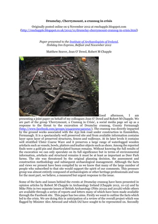
1. Drumclay, Cherrymount, a crannog in crisis
Originally posted online on 9 November 2012 at rmchapple.blogspot.com
(http://rmchapple.blogspot.co.uk/2012/11/drumclay-cherrymount-crannog-in-crisis.html)
Paper presented to the Institute of Archaeologists of Ireland,
Holiday Inn Express, Belfast 2nd November 2012
Matthew Seaver, Jean O’ Dowd, Robert M Chapple
Good afternoon, I am
presenting a joint paper on behalf of my colleagues Jean O’ Dowd and Robert M Chapple. We
are part of the group ‘Cherrymount, a Crannog in Crisis’, a social media page set up as a
response to the threat to the excavation of Drumclay crannog, County Fermanagh
(http://www.facebook.com/groups/254450291340252/). The crannog was directly impacted
by the ground works associated with the A32 link road under construction in Enniskillen,
Fermanagh. It is a spectacularly well preserved site and from available information contains
layer upon layer of preserved structures, fences and walkways. At its later levels it contains
well stratified Ulster Coarse Ware and it preserves a large range of waterlogged wooden
artefacts such as vessels, bowls, platters and leather objects such as shoes. Among the reported
finds were a gold pin and disarticulated human remains. Without knowing the full results of
the excavation we can only speculate on its full significance but in terms of environmental
information, artefacts and structural remains it must be at least as important as Deer Park
farms. The site was threatened by the original planning decision, the assessment and
construction methodology and subsequent archaeological management. Although the facts
and views we present have been compiled by us we know that many of the large number of
people who subscribed to that site would support the spirit of our comments. This pressure
group was almost entirely composed of archaeologists or other heritage professionals and was
for the most part, we believe, a measured but urgent response to the issue.
Some of the facts and issues behind the events at Drumclay crannog have been presented in
opinion articles by Robert M Chapple in Archaeology Ireland (Chapple 2012, 10-12) and by
Mike Pitts in two separate issues of British Archaeology (Pitts 2012a and 2012b) while others
are available through a series of reports and letters many of which have been made available
through the Facebook site. This paper has two aims. Firstly we want to outline the facts which
led to the crisis. We are doing this in anticipation of a review of the overall project which was
flagged by Minister Alex Attwood and which IAI have sought to be represented on. Secondly
2. we want to suggest a number of issues which arise from the crisis which could be useful in the
recovery which will hopefully follow.
From the outset we want to state that we fully support the current excavation strategy and
team which is headed by specialists in wetland archaeology. We also fully support the changes
put in place to the site excavation strategy by Minister Attwood and the respected members of
the Historic Monuments Council and the other archaeological specialists brought in to advise
him. A number of senior early medieval archaeologists and local politicians were also crucial
to the eventual outcome. From the outset, as I pointed out to a BBC journalist, this was not a
case of protesters climbing trees to prevent a road being built. The protest represented the
concerns of professionals. First and foremost the inspiration came from the site crew who
brought the matter to our attention. Robert M Chapple was the first to flag the issue on his
blog and was the inspiration for the campaign which followed. Jean O’ Dowd is a wetland
archaeologist and immediately became very concerned over the information emerging from
the site. She visited the site and was in close contact throughout with the excavation crew. She
set up the social media campaign and was the passionate driving force behind it. I am a
member of the IAI and concerned with among other things Early Medieval Archaeology and
was extremely interested and worried from the outset at issues concerning the site and the
staff.
The A32 link road was designed to link the northern outskirts of Enniskillen to the A4 Dublin
road which would relieve traffic from the town centre. Drumclay is a townland to the northeast
of Enniskillen town centre. The whereabouts of a crannog at Drumclay was marked on the first
and second edition Ordnance survey maps and was recorded by Wakeman in the 1870s along
with the position of a dugout canoe which was subsequently reburied. This crannog
(FER211:061) was located on the line of the proposed alignment, 180m to the NW of the
proposed roundabout at Lower Chanterhill Road and Coa Road.
2007-2011 The Cherrymount Link Road road was planned by the Roads Service within the
Department of Regional Development. The environmental impact assessment was co-
ordinated by RPS Planning and Environment Consultants and was conducted in 2007. The
archaeological assessment of the route comprised a standard desktop survey and included a
walkover by two qualified archaeologists who could not ascertain the exact location of the
crannog and dug out site due to poor drainage and lack of access. A non-technical summary of
that report did state however that The site will be directly impacted by the proposed link road.
As such it may be located within or adjacent to the area for proposed ground disturbance
works (http://www.drdni.gov.uk/publications-details.htm?docid=4108). It noted that
3. investigative works would have to be carried out in compliance with the requirements of the
relevant state body (Environment and Heritage Service). In February 2009 the Department of
Regional Development published its notice of intent to proceed with the road after the
consultation process and noted that The proposed Cherrymount Link Road will directly
impact on two recorded archaeological sites, a crannog and a dug-out canoe. The area of
water around the crannog has been partially land-filled and the feature identified as an
island on the 1835 and 1860 editions of the OS mapping is now lost and buried. The dugout
canoe associated with the crannog was subsequently reburied and lost in this area and
indicated that Mitigation includes archaeological monitoring during topsoil stripping. All
potential archaeological sites that are subject to unavoidable partial or total destruction
should be fully archaeologically recorded, therefore preserving the sites by
record (http://www.drdni.gov.uk/index/publications/publications-az-
results.htm?letter=n&)
In direct commentary in August 2012 (which can be viewed on the groups Facebook page,
posted by Jean O’ Dowd 21st August) on the route selection a spokesman for the Roads Service
said that the proposed line of the new road was being heavily influenced by many other
factors, not least extremely poor ground conditions and the high land values of
the day. According to this document the roads service said that the likelihood of finding the
crannog was low and if found it was their view that it could be preserved in situ.
10th March 2011 –Archaeological testing did
eventually take place on site once a temporary stoned haul route was placed across the
site. The Archaeological Investigations Report Document (Anon 2011a, reference
CO400330/E/A01) confirmed that the crannóg had survived in the location on Ordnance
survey maps (albeit slightly further north) after the test investigations, which were carried out
in January 2011 and the site was recorded in survey as measuring 17 x 14.5m, this defined by
a raised circular area of differential vegetation. This assessment was conducted by an
archaeologist employed by the construction contractor. Engineering boreholes dug at the same
time revealed 6.1m of peat in the vicinity.
4. The investigative methodology involved excavating a single 3 x 3m trench opened to the west
of the haul road in the centre of the crannog. This trench revealed well preserved structural
remains, organic and inorganic artefacts and clearly demonstrated that the crannog was a
complex and relatively intact structure. The depth of stratigraphy was thought to be 0.6m in
depth in the centre of the crannog although the trench did not go below this level due to
waterlogging. It was proposed at this stage to preserve the site in situ under the road.
Unfortunately it is unclear whether this copy of the report made available to the group and to
Mike Pitts of British Archaeology was the final version as it had been inexpertly edited with
crucial pages related to the proposed engineering solution to the crannog omitted. It is
therefore difficult to know the specifics of the proposed engineering solution and the
comments on it from the roads department and the Northern Ireland Environment Agency.
When asked to comment on the initial test excavation by British Archaeology the department
of regional development said that ‘nothing of significance was unearthed’ (Pitts 2012b). It is
clear that the assessment could not assess the overall extent and depth of the
archaeological deposits on site but did ascertain that the site was complex and
well preserved.
According to the Roads Service (again in the document
available on the group’s website in response to queries in July 2012, Post from Jean O’ Dowd
August 21st) at an early stage negotiations with the successful contractor it was proposed to
excavate parts of the route to 9m in depth in places around up to 5m away from the crannog
and to replace the extracted material with rock. The site of the crannog was to be bridged
according to the Roads Service. The Roads Service claims that this methodology was
agreed with the NIEA. It is unclear whether this work was monitored by the archaeologist
on site. It is clear from the methodology outlined in this document that the
crannog and its environs would be unlikely to survive these alterations to the
environment in which it was preserved.
April 2012 – The water levels around the crannog were lowered following road excavation
works which evidently left the site drying out and exposed. The solid material (presumably the
hardcore stone surrounding the crannog) sank. This document states that machine excavation
works were taking place 20m away from the crannog site. The northern part of the site showed
significant large cracks to 6m in depth when inspected. Members of the original excavation
crew suggest that there were clear indications that machines had been active in this part of the
site and this would appear to accord with the original contractor’s methodology cited by the
Roads Service.
5. May 2012 – At this stage an excavation methodology (reference C04003330E/A/01) was
devised to attempt to mitigate the damage. The method statement indicates that it was
considered to either preserve the crannog by laying a geo grid over it or to excavate the
occupation levels of the crannog which would allow piles to be excavated through the
‘construction body of the crannog’. There was no mention in the excavation methodology of
consultation with wetland archaeological specialists. This initial fieldwork was to take four to
six weeks with a proviso that further time might be needed. It is unclear whether any
comments were made about the extremely short timescale of these works or
about the lack of a clear written strategy for environmental sampling. It is also
unclear as to whether there were any concerns over the lack of assessment of
the stratigraphy below 0.6m which would clearly be impacted by the piling.
Even if they were construction levels they would surely hold vital information
about the sites evolution over time, never mind the possibility that earlier
structures could be present. These layers were subsequently found to contain
the remains of complex structures.
July 2012 – Excavation began
on site in July 2012 with the site director employed by the construction company and a small
crew of archaeologists contracted from another archaeological consultancy. The excavation
crew recorded that the site was reduced in size by the time they had arrived to c. 10 x 8m. The
northern part of the crannóg appeared to have been completely removed when the crew started
the excavation. Fieldwork was to end on the 20th July.
A significant number of experienced members of the crew were concerned at the level of
recording on site, the lack of a clear and coherent environmental sampling strategy and the
absence of timber recording sheets. According to them there was no suitable storage facility
on site for the significant quantity of organic artefacts emerging from the site. In addition
construction traffic continued in and around the fragile site.
As the deadline for the end of excavation approached members of staff made representations
to the Northern Ireland Environment Agency on the 5th and 17th July and when this did not
seem to have an impact on the approaching deadline they contacted Robert M Chapple who
made the decision to publicise the difficulties through his blog
(http://rmchapple.blogspot.ie/2012/07/urgent-important-early-christian.html). Robert
subsequently appeared on BBC Radio Ulster’s ‘Good Morning Ulster’ programme (18th July
2012). An offer to respond was made to those responsible for the construction of the route but
6. was declined. Robert also recorded an interview for RTE Morning Ireland who did not
broadcast it as the archaeological project management on site were quoted as saying they were
happy with the allocated time.
Subsequently photographs were supplied to the blog to highlight the scale and range of
archaeological remains and on foot of this a staff member from the site was dismissed on the
19th July. Representations made to some politicians initially brought the response that the
archaeologist (i.e. the project management) on site had said that they were happy with a two
day extension with a limited crew. This was despite the fact that photographs documented
large levels of excavation layers remaining intact.
The BBC picked up on the story on the 26th of July reporting the road services Seamus
Keenan “If we had known the crannog was in the area at the early stages we would have
done everything we could to avoid it. In this case, we are dealing with an area which is a
water logged bog essentially. It was only late in the day that we realised that the crannog
was right there in the road line” (http://www.bbc.co.uk/news/uk-northern-ireland-
18998749). By the fourth update of this story by the BBC this comment had disappeared and
following clarification by various people the story included some mention of the concerns of
archaeologists (http://www.newssniffer.co.uk/articles/539224/diff/3/4). This was a
significant action and the type of thing that a media strategy should set out to
accomplish.
July 23rd 2012 - A social network site was set up on
Facebook by Jean O’ Dowd ‘Cherrymount: a crannog in crisis’.. It received a huge number of
members and while there were problems with settings initially which meant that some people
were inadvertently added by colleagues without their consent this was rectified very quickly
and it retained over 600 members. It attempted to bring pressure on government agencies,
local and national politicians through direct appeals, media and through professional
archaeological bodies. A number of local politicians became heavily involved and remained
vital to the eventual outcome. IAI issued a statement within their weekly newsletter (IAI
weekly update available to members) on the 20th of July that they had written to the minister
to ascertain the steps taken to secure the preservation of the site while the Institute of Field
Archaeologists placed a news item on their website on the 25th July where they noted their
concerns (http://www.archaeologists.net/news/120725-crannog-site-drumclay-co-
fermanagh). While the IAI were following the correct procedure looking for the
facts of the case the publication on the web of the news item with the IFA led to
far more coverage as it was publicly accessible.
7. On July 30th 2012 Minister Alex Attwood issued a statement in which he instructed
construction traffic to cease in and around the crannog. He said that from that time onwards
he would assess the needs of the excavation and would have a strategy for maximum recording
of the site. He acknowledged that there were significant issues around the planning of the road
in relation to archaeology which could influence future policy on such matters. The
archaeological team was redesigned to be led by specialists in wetland archaeology and given
at least eight further weeks to excavate it. The excavation is still on going and is expected to
end in the coming month. The Northern Ireland Environmental Agency has also said that a
proper programme of post excavation and publication will be put in place ‘we expect that a
design for post-excavation work to follow immediately after the excavation and
look forward to the publication of the work on several levels. All of the work
will be in accordance with best professional and internationally recognised
standards’ (TOF/524/2012).
Apart from the planning and professional issues raised by this paper, the recovery cannot be
discussed without reference to the original crew of the site. The contracts held by the original
site team were up by the end of the excavation and a number of the crew were not taken on
when excavations resumed.
Martin Carver in his recent book ‘Making Archaeology Happen’ (Carver 2011) saw that the
future for archaeology was to emphasise the idea of project design and to have a smaller
number of highly skilled professionals who are all an integrated part of the excavation team.
This would lead to better research, more public respect, and better wages.
The events at Drumclay crannog are extreme but serve to highlight the treatment of
archaeological staff. They could not be further from Carvers model if they tried. The position
they hold, on short term contracts subcontracted from another company means they have very
little buy-in to the project. The staff showed their absolute commitment to the project through
trying everything to record the site. Their distance from the project management and the
confidentiality clauses set into contracts meant that they could not be part of the process.
Publicly releasing information is not the ideal solution but in this case without the weight of
public opinion it is unlikely that the current excavation strategy would have been adopted.
The hierarchical rather than collegial nature of site excavations means that the concerns of
experienced site assistants or supervisors may not be taken seriously. There is a need for a
mechanism in both jurisdictions in the Island for a system of complaints. These should be
formally logged, investigated with a written record of how the issue was dealt with. There
should be safeguards both for those making the complaint and the party against whom the
claim is made until sufficient investigation takes place and measures taken to rectify it where
possible.
The IAI can have a role in taking part in such a system, whether by setting up its own
whistleblowing scheme or taking an active part in any state run initiatives.
The chain of events which led to the planning of the route, assessment and excavation at
Drumclay all has serious implications none of which are the sole responsibility of a single body
or individual. The issues outlined in today’s paper will hopefully place some of these events in
context. The actions of the crew of archaeologists were instrumental in changing the course of
the excavation. Let us hope that the review will contribute to the way future projects are
planned and to how archaeological teams are treated.
References
8. Anon 2011 Cherrymount Link Road Scheme, Archaeological Investigations,
CO400330/E/A01, Issue 1, 10 March 2011, Unpublished Report by Amey submitted to the
Northern Ireland Environment Agency.
Anon 2011 Cherrymount Link, Archaeological Methodology, Crannog Excavation
Methodology, C0400330/E/A01, Issue 1, May 2012, Unpublished Report by Amey submitted
to the Northern Ireland Environment Agency.
Carver, M 2011 Making Archaeology Happen, Left Coast Press.
Chapple, R M 2012 ‘Cherrymount Crannog, Fermanagh’ Archaeology Ireland, Autumn 2012,
Vol. 26, No.3, Issue No. 101, 10-12.
Pitts, M 2012a ‘Why was major site lost in Northern Ireland Bog’ British Archaeology,
September/October, 11-12.
Pitts, M 2012b ‘Nothing of Significance was unearthed’ British Archaeology,
November/December, 6.