Rivers - George Mather, Chris Hancox, Alex Owen and Michael Soley
RiverStream Initiative 2014
1. Sustainability Commission
Economy • Environment • Society
Think long-term, act now
“Community Sustainability is the commitment to adopt practices that support and
balance the social, economic and environmental aspects of our region, now and
into our future.”
Groton Sustainability Commission, Winter 2010
Sustainability Commission, Groton Town Hall, 173 Main St., Groton, MA 01450
sustaining@townofgroton.org · (978) 448-1111 · www.SustainingGroton.org
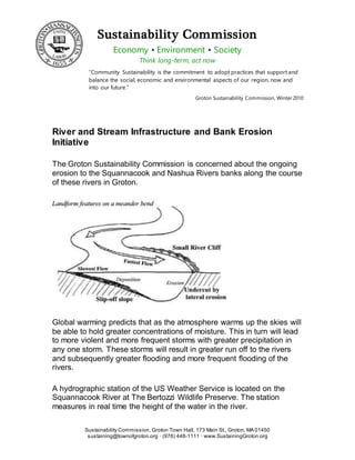
River and Stream Infrastructure and Bank Erosion
Initiative
The Groton Sustainability Commission is concerned about the ongoing
erosion to the Squannacook and Nashua Rivers banks along the course
of these rivers in Groton.
Global warming predicts that as the atmosphere warms up the skies will
be able to hold greater concentrations of moisture. This in turn will lead
to more violent and more frequent storms with greater precipitation in
any one storm. These storms will result in greater run off to the rivers
and subsequently greater flooding and more frequent flooding of the
rivers.
A hydrographic station of the US Weather Service is located on the
Squannacook River at The Bertozzi Wildlife Preserve. The station
measures in real time the height of the water in the river.
2. 16-Jul-167/16/2016 Groton Sustainability Commission 2 of 2
Graphs made up by the US Weather Service from the data collected at
the Squannacook hydrographic station show that both the height of
floods and the frequency of floods have continued to increase since the
1980s. This is a result that would be expected as an effect of increased
global warming.
One of the results of the frequent and intense flooding of the rivers is
the erosion of the river banks.
In many places along the Squannacook and Nashua in Groton the
banks once vegetated have now become raw sand. The banks have
widened and large old trees that for decades were growing in what was
the bank by the river have now fallen into the river. As a result the rivers
are full of trees.
The evidence of recent river bank erosion on the Nashua can be seen
by taking a walk along the Sabine Woods trail, the Northern extension
of Groton Place. Here you can see huge old trees growing on the river
bank. They must have been there for hundreds of years. There roots
are interestingly growing horizontally straight back into the river bank
indicating they were always growing on the river bank. Now these roots
are greatly exposed as the river bank has eroded away and the trees
themselves look almost cantilevered over the edge of the bank. Many of
these huge trees have recently fallen into the river.
An area of erosion on the Squannacook River is of some concern. The
river flows South just West of West Groton bridge on route 225.
There the river takes a right angle turn eastward.
The river bank at this juncture has eroded away. A large pine tree
growing there has fallen into the river and another growing behind it has
its roots undercut. As the erosion here continues to progress it will
threaten route 225.
As demonstrated by our eroding river banks, Global Warming and its
results are not just a thing of the future, they are with us now.
For additional Information Please Contact Carl Canner
carlcan@aol.com