TCE 516 –Water Resources
Management
By
Dr C.G. Achi
Department of Civil Engineering
University of Ibadan
2.
Overview of waterresources and their
significance in sustainable development
Water is a fundamental resource essential for life, ecosystems, and
economic development. It is critical for agriculture, industry, energy
production, domestic use, and maintaining ecological balance.
The sustainable management of water resources is crucial for
addressing global challenges such as population growth, climate
change, and resource scarcity.
3.
Water resources referto the sources of water that are available for
use by humans, animals, and ecosystems. These include:
1. Surface Water
Definition: Water found on the surface of the Earth, such as rivers,
lakes, reservoirs, streams, and wetlands.
Uses:
• Drinking water supply.
• Irrigation for agriculture.
• Hydropower generation.
• Recreation and transportation.
4.
2. Groundwater
Water storedbeneath the Earth's surface in aquifers.
Uses:
• Primary source of drinking water in many rural and urban areas.
• Irrigation in arid and semi-arid regions.
• Industrial processes.
3. Rainwater
Water that falls to the Earth as precipitation.
Uses:
• Harvested for domestic use, especially in regions with unreliable water supply.
• Recharge of groundwater and replenishment of surface water bodies.
5.
4. Desalinated Water
Waterproduced by removing salts and minerals from seawater or brackish water.
Uses:
• Drinking water in arid regions.
• Industrial processes where high-quality water is required.
5. Recycled/Reuse Water
Treated wastewater that is reused for various purposes.
Uses:
• Agricultural irrigation.
• Industrial cooling and processes.
• Urban landscaping and non-potable domestic uses.
Water is criticalfor achieving sustainable development goals (SDGs) and
fostering economic growth, environmental health, and social equity. Below
are the key areas where water resources play a significant role in
sustainable development:
1. Ensuring Access to Clean Water and Sanitation (SDG 6)
Access to clean water is a fundamental human right and a key
determinant of public health.
Lack of access to safe drinking water and sanitation leads to waterborne
diseases such as cholera, dysentery, and diarrhea, which
disproportionately affect children and vulnerable populations.
8.
2. Supporting FoodSecurity
Agriculture:
Agriculture accounts for about 70% of global freshwater use.
Sustainable irrigation practices are essential to meet the
food demands of a growing population while reducing water
wastage.
Challenges:
Over-extraction of water for irrigation can deplete aquifers
and reduce river flows, threatening ecosystems and downstream
communities.
9.
3. Driving EconomicGrowth
Energy Production:
Hydropower is a major renewable energy source that depends on water availability.
Thermoelectric power plants rely on water for cooling.
Industry:
Water is essential for industrial processes, including manufacturing, mining, and construction.
Tourism and Recreation:
Water-based tourism and recreational activities contribute to local and national economies.
4. Mitigating Climate Change Impacts
Climate change affects the hydrological cycle, altering precipitation patterns, increasing the
frequency of droughts and floods, and impacting water availability.
Sustainable water management helps communities adapt to climate change by ensuring reliable
water supply and reducing vulnerability to extreme weather events.
10.
5. Protecting Ecosystems
Healthyecosystems, such as wetlands, rivers, and forests, depend on adequate water
availability.
These ecosystems provide critical services, such as water purification, flood control, and
carbon sequestration.
Overuse and pollution of water resources threaten biodiversity and ecological balance.
6. Promoting Social Equity
Inequitable water distribution can exacerbate poverty, inequality, and conflicts.
Ensuring equitable access to water resources fosters social stability and improves the
quality of life for marginalized communities.
11.
Challenges in SustainableWater Resource Management
1. Water Scarcity:
• Increasing demand due to population growth and economic activities.
• Over-extraction of groundwater and depletion of aquifers.
2. Water Pollution:
• Contamination from agricultural runoff, industrial discharge, and untreated sewage.
• Microplastics and emerging pollutants in water bodies.
3. Climate Change:
• Altered precipitation patterns leading to more frequent droughts and floods.
• Melting glaciers reducing freshwater availability in downstream regions.
12.
Challenges in SustainableWater Resource Management
4. Inefficient Use of Water:
• High levels of water wastage in agriculture, industry, and domestic use.
5. Governance and Policy Gaps:
• Lack of integrated water resource management (IWRM) frameworks.
• Weak enforcement of water quality and usage regulations.
13.
Strategies for SustainableWater Management
1. Integrated Water Resource Management (IWRM):
Coordinating the development and management of water, land, and related resources to
maximize social and economic benefits without compromising the sustainability of ecosystems.
2. Water Conservation Techniques:
Adoption of efficient irrigation methods (e.g., drip and sprinkler systems).
Rainwater harvesting and groundwater recharge.
3. Pollution Control Measures:
Treating wastewater before discharge.
Reducing the use of harmful chemicals in agriculture and industry.
14.
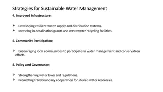
Strategies for SustainableWater Management
4. Improved Infrastructure:
Developing resilient water supply and distribution systems.
Investing in desalination plants and wastewater recycling facilities.
5. Community Participation:
Encouraging local communities to participate in water management and conservation
efforts.
6. Policy and Governance:
Strengthening water laws and regulations.
Promoting transboundary cooperation for shared water resources.
15.
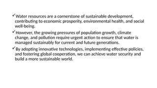
Water resources area cornerstone of sustainable development,
contributing to economic prosperity, environmental health, and social
well-being.
However, the growing pressures of population growth, climate
change, and pollution require urgent action to ensure that water is
managed sustainably for current and future generations.
By adopting innovative technologies, implementing effective policies,
and fostering global cooperation, we can achieve water security and
build a more sustainable world.
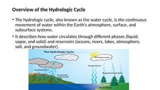
Overview of theHydrologic Cycle
• The hydrologic cycle, also known as the water cycle, is the continuous
movement of water within the Earth’s atmosphere, surface, and
subsurface systems.
• It describes how water circulates through different phases (liquid,
vapor, and solid) and reservoirs (oceans, rivers, lakes, atmosphere,
soil, and groundwater).
18.
Key Processes inthe Hydrologic Cycle
Evaporation:
• Water from oceans, rivers, lakes, and soil is converted into water vapor due to solar
heat.
Transpiration:
• Plants release water vapor into the atmosphere through their leaves.
• Combined with evaporation, this process is referred to as evapotranspiration.
Condensation:
• Water vapor cools and condenses into tiny droplets, forming clouds or fog.
19.
Precipitation:
• Water fallsback to Earth as rain, snow, sleet, or hail when clouds become saturated.
Infiltration:
• Precipitated water seeps into the ground, replenishing soil moisture and groundwater aquifers.
Runoff:
• Excess water flows over the land into rivers, lakes, and oceans.
Storage:
• Water is temporarily stored in reservoirs such as glaciers, lakes, aquifers, and vegetation before re-
entering the cycle.
20.
Role of theHydrologic Cycle in Water Resources Planning
• The hydrologic cycle forms the foundation for water resources
planning by providing insights into the availability, distribution, and
movement of water.
• Effective management of water resources relies on understanding the
components of the hydrologic cycle and their interactions within the
environment.
21.
Role of theHydrologic Cycle in Water Resources Planning
1. Estimating Water Availability
Surface Water Resources:
• Precipitation determines the amount of water available in rivers, lakes, and
reservoirs.
• Runoff models, derived from the hydrologic cycle, help assess surface water
flows.
Groundwater Resources:
• Infiltration, percolation, and recharge processes define the capacity of aquifers
to store and supply groundwater.
Seasonal and Regional Variations:
• Understanding seasonal precipitation patterns, such as monsoons or
snowmelt, is critical for planning water storage infrastructure.
22.
Role of theHydrologic Cycle in Water Resources Planning
2. Flood Management
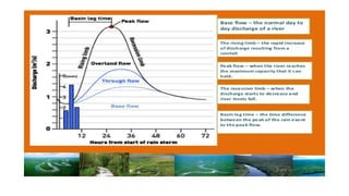
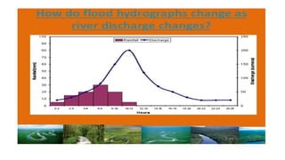
Runoff and Flood Prediction:
• Excess precipitation and runoff lead to floods.
• Hydrologic models simulate rainfall-runoff relationships to predict
flood events.
Design of Control Structures:
• Dams, levees, and floodplains are designed using hydrologic data
to mitigate flood risks and protect communities.
23.
Role of theHydrologic Cycle in Water Resources Planning
3. Drought Management
Monitoring Water Deficits:
• The hydrologic cycle provides insights into precipitation deficits, soil
moisture loss, and reduced groundwater recharge during droughts.
Water Storage and Conservation:
• Planning reservoirs and promoting rainwater harvesting ensure water
availability during dry periods.
Drought Early Warning Systems:
• Hydrologic data combined with climate forecasting helps in drought
prediction and preparedness.
24.
Role of theHydrologic Cycle in Water Resources Planning
4. Groundwater Management
Recharge Assessment:
• Understanding infiltration and percolation rates helps estimate
aquifer recharge.
Sustainable Groundwater Use:
• Over-extraction of groundwater disrupts the balance of the hydrologic
cycle, leading to depletion. Proper planning ensures sustainable use.
Artificial Recharge Techniques:
• Methods like groundwater injection and managed aquifer recharge
(MAR) are designed based on hydrologic studies to replenish aquifers.
25.
Role of theHydrologic Cycle in Water Resources Planning
5. Water Supply Planning
Demand-Supply Balance:
• Hydrologic data is essential for matching water availability to
domestic, agricultural, and industrial demands.
Infrastructure Design:
• Water supply systems, such as pipelines, storage tanks, and
treatment plants, are designed based on precipitation and runoff
patterns.
26.
Role of theHydrologic Cycle in Water Resources Planning
6. Irrigation Planning
Evapotranspiration Estimates:
• Understanding the rate of evapotranspiration helps determine
irrigation requirements for crops.
Water Allocation:
• Hydrologic models assist in allocating water for irrigation while
ensuring ecological water needs are met.
27.
Role of theHydrologic Cycle in Water Resources Planning
7. Addressing Climate Change Impacts
Changing Precipitation Patterns:
• Climate change alters the hydrologic cycle, causing more extreme
weather events (e.g., floods, droughts).
• Hydrologic models help predict and plan for these changes.
Glacier and Snowmelt Contributions:
• Melting glaciers and reduced snowpack due to global warming
affect water availability in downstream regions.
28.
Role of theHydrologic Cycle in Water Resources Planning
8. Water Pollution Control
Runoff and Pollution Transport:
• Runoff from agricultural, industrial, and urban areas carries
pollutants into water bodies.
• Understanding runoff characteristics helps design pollution control
strategies, such as riparian buffers and wetlands.
Groundwater Contamination:
• Understanding groundwater flow helps identify contamination risks
and plan for remediation.
29.
Role of theHydrologic Cycle in Water Resources Planning
9. Hydropower Development
Flow Availability:
• River discharge patterns derived from the hydrologic cycle are
critical for planning hydropower projects.
Reservoir Management:
• Storage reservoirs are designed and operated using hydrologic
data on seasonal flows and evaporation rates.
30.
Role of theHydrologic Cycle in Water Resources Planning
10. Ecosystem and Environmental Sustainability
Environmental Flows:
• Maintaining minimum flow levels in rivers is essential for
sustaining aquatic ecosystems.
• Hydrologic data is used to determine these environmental flow
requirements.
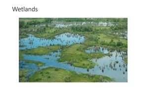
Wetland Conservation:
• Wetlands, which act as natural water filters and flood buffers, are
managed using insights from the hydrologic cycle.
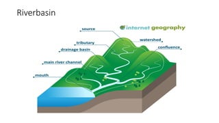
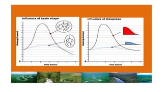
A river basinsystem is a geographical area drained by a river and its
tributaries.
It acts as a natural system for collecting, storing, and channeling
water from precipitation (rainfall or snowmelt) toward a common
outlet, such as a lake, sea, or ocean.
River basins are key hydrological units used for managing water
resources, ecosystems, and human activities.
35.
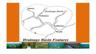
Key Features ofa River Basin System
1. Main River and Tributaries:
• The central river forms the spine of the basin, with tributaries joining it at various points.
• Tributaries increase the flow of the main river by collecting runoff from smaller areas.
2. Watershed or Drainage Divide:
• The boundary of a river basin is defined by a watershed or drainage divide, which separates one
basin from another.
• It is typically formed by highlands, ridges, or mountain ranges.
3. Catchment Area:
• The catchment area includes all the land within the basin where water collects and flows toward
the river system.
36.
4. Outlet:
• Thepoint where the river discharges its water, such as into a larger water body (sea, ocean, or
lake).
5. Floodplains:
• Low-lying areas adjacent to the river that are prone to flooding during high flow conditions.
6. Storage Features:
• Natural features like wetlands, lakes, and reservoirs that temporarily or permanently store
water.
7. Groundwater Recharge Zones:
• Areas within the basin where infiltration of water occurs, replenishing underground aquifers.
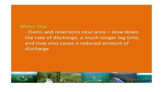
Challenges in RiverBasin Systems
1. Water Scarcity:
• Over-extraction of water for agriculture, industry, and domestic use reduces
availability for downstream regions.
2. Pollution:
• Industrial discharge, agricultural runoff, and untreated sewage pollute rivers,
degrading water quality and ecosystems.
3. Flooding:
• Excessive rainfall or rapid snowmelt can overwhelm the river’s capacity, leading
to floods.
.
39.
4. Climate ChangeImpacts:
• Changing precipitation patterns and rising temperatures affect river flows,
leading to droughts or intensified flooding.
5. Conflict Over Water Use:
• Shared river basins between regions or countries often lead to disputes over
water allocation and usage rights (e.g., the Nile, Indus, and Mekong basins).
6. Deforestation and Erosion:
• Deforestation in the upper basin increases soil erosion, reducing water quality
and causing sedimentation in reservoirs
40.
Integrated River BasinManagement (IRBM)
To address challenges and ensure sustainable development, Integrated River
Basin Management (IRBM) is widely adopted. This approach considers the
entire basin as a single system and aims to balance water use, ecosystem
health, and social needs.
Key Elements of IRBM:
1. Stakeholder Involvement:
• Engaging local communities, governments, and industries in decision-
making.
2. Water Allocation:
• Equitable distribution of water across sectors and regions.
41.
Key Elements ofIRBM
3. Pollution Control:
• Reducing point and non-point sources of pollution.
4. Flood and Drought Management:
• Developing infrastructure and policies to mitigate extreme events.
5. Ecosystem Conservation:
• Protecting wetlands, forests, and aquatic habitats within the basin.
42.
Examples of MajorRiver Basins in the World
• Amazon Basin (South America): The largest river basin in the world, critical
for biodiversity and climate regulation.
• Nile Basin (Africa): Shared by 11 countries, it is vital for agriculture and
hydropower but is subject to water-sharing conflicts.
• Ganges-Brahmaputra-Meghna Basin (South Asia): Supports millions of
people and is crucial for agriculture but faces challenges like flooding and
pollution.
• Mississippi River Basin (North America): An essential system for agriculture,
industry, and navigation.
43.
Examples of RiverBasins in Nigeria
• Nigeria has several river basins that play a critical role in water
resources management, agriculture, ecosystem balance, and energy
generation.
• These river basins are formed by major rivers and their tributaries,
with the two most significant rivers being the Niger River and the
Benue River.
• Below are key examples of river basins in Nigeria:
44.
1. Niger RiverBasin
Overview:
• The Niger River is the longest river in Nigeria and the third longest in Africa, spanning over 4,180 km.
• It originates from the Fouta Djallon Highlands in Guinea and flows through Mali, Niger, and Nigeria
before emptying into the Atlantic Ocean via the Niger Delta.
Significance:
• The Niger River Basin is critical for agriculture, fishing, transportation, and hydropower generation in
Nigeria.
• It supports major cities like Lokoja, Onitsha, and Yenagoa.
Key Features:
• Tributaries in Nigeria: Kaduna River, Sokoto River, Anambra River, and Nun River.
• Niger Delta: The delta is one of the world’s largest wetlands and a biodiversity hotspot.
45.
2. Benue RiverBasin
Overview:
• The Benue River is the largest tributary of the Niger River and flows through northeastern
Nigeria.
• It originates in Cameroon and joins the Niger River at Lokoja.
Significance:
• The basin is vital for agriculture, as its floodplains are fertile and support rice and other crops.
• It is also crucial for fishing and transportation.
Key Features:
• Tributaries: Gongola River, Katsina Ala River, and Taraba River.
• Major Cities Along the Basin: Yola, Makurdi, and Lokoja.
46.
3. Chad Basin
Overview:
•The Chad Basin is located in northeastern Nigeria and covers parts of Borno, Yobe, and Adamawa
states.
• The basin includes Lake Chad, which is shared by Nigeria, Chad, Niger, and Cameroon.
Significance:
• The basin supports millions of people through fishing, livestock rearing, and irrigation.
• However, Lake Chad has significantly shrunk in size due to climate change and overuse of water
resources.
Key Features:
• Rivers in the Basin: Yobe River, Ngadda River, and Komadugu River.
• Challenges: Desertification, water scarcity, and conflicts over water resources.
47.
4. Sokoto-Rima RiverBasin
Overview:
• This basin is located in northwestern Nigeria and is formed by the Sokoto River and its tributary,
the Rima River.
• Both rivers eventually flow into the Niger River.
Significance:
• The basin supports large-scale irrigation projects, including the Bakolori Dam.
• It is a key area for the cultivation of crops like rice, millet, and wheat.
Key Features:
• Major Cities: Sokoto, Gusau, and Kebbi.
• Dams and Projects: Bakolori Dam for irrigation and hydropower.
48.
5. Cross RiverBasin
Overview:
• The Cross River originates in Cameroon and flows through southeastern Nigeria,
emptying into the Atlantic Ocean.
Significance:
• It is an important waterway for fishing, agriculture, and forestry.
• The basin supports biodiversity, including rainforests and mangroves.
Key Features:
• Tributaries: Calabar River and Kwa River.
• Major Cities: Calabar and Uyo.
49.
6. Ogun-Osun RiverBasin
Overview:
• This basin covers southwestern Nigeria and includes the Ogun and Osun Rivers.
• Both rivers flow into the Lagos Lagoon and eventually into the Atlantic Ocean.
Significance:
• The basin is vital for domestic water supply, agriculture, and urban development in
Lagos and Ogun States.
Key Features:
• Key Dams: Oyan Dam and Ewekoro Dam.
• Major Cities: Lagos, Abeokuta, and Ibadan.
50.
7. Imo RiverBasin
Overview:
• The Imo River flows through southeastern Nigeria and empties into the Atlantic
Ocean.
• It is a relatively smaller but significant basin in the region.
Significance:
• The basin supports agriculture, fishing, and domestic water supply.
Key Features:
• Tributaries: Aba River and Otamiri River.
• Major Cities: Owerri and Aba.
51.
8. Anambra RiverBasin
Overview:
• The Anambra River is a major tributary of the Niger River, located in southeastern
Nigeria.
Significance:
• The basin supports agriculture and fishing in Anambra State.
• It is also critical for floodplain farming.
Key Features:
• Floodplains: Fertile lands for rice cultivation.
• Major Cities: Onitsha and Awka.
52.
9. Hadejia-Jama’are-Komadugu-Yobe Basin
Overview:
•This basin is located in northern Nigeria and includes the Hadejia, Jama’are, Komadugu,
and Yobe Rivers.
• These rivers flow into the Chad Basin.
Significance:
• The basin supports agriculture, fishing, and groundwater recharge.
• It is crucial for sustaining livelihoods in arid regions.
Key Features:
• Wetlands: The Hadejia-Nguru Wetlands are important for biodiversity and agriculture.
• Challenges: Water scarcity and upstream dam impacts.
53.
10. Niger DeltaBasin
Overview:
• The Niger Delta is the most extensive river delta in Nigeria, located where the Niger
River meets the Atlantic Ocean.
Significance:
• It is rich in biodiversity and natural resources, including oil and gas.
• The basin supports fishing, agriculture, and aquaculture.
Key Features:
• Wetlands and Mangroves: Critical for fisheries and climate regulation.
• Challenges: Environmental degradation due to oil spills and pollution.