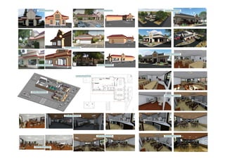
Restaurant (4717 n lagoon ave)
•
0 likes•13 views

Restaurant (4717 n lagoon ave)
Report
Share
Report
Share
Download to read offline
Recommended
Via wsperia, san diego, ca 92014 
This document contains elevation data for multiple levels of a building, including the lowest level, street level, garage, and several second levels. The elevations range from approximately 90 to 120 feet. A scale of 1/4 inch equals 1 foot is provided.
Valasaravakkam
The document contains architectural plans and drawings for a multi-level residential building including a ground floor, second floor, terrace, and parking area. Dimensions and room labels are provided for the building layout, plumbing, and electrical plans. Elevations are shown from the north, south, east, and west sides. 3D renderings from multiple angles are also included to visualize the overall building design.
University ave
This document contains a series of numbers and symbols that appear to be measurements in feet and inches describing the dimensions of a multi-level structure. There are labels indicating the measurements are for the lower level, second level, and third level. The measurements include lengths like 20' - 9" and heights like 5'-0".
Residential building villa2
This document contains technical building information including floor elevations and labels for architectural drawings. It lists the ground, first floor, roof, and grade elevations in meters for a building. It also includes scale information and directional labels that will be used on accompanying plans.
Pathot revit model
The document contains a floor plan layout with labels for rooms on the basement, ground, and second floors including dimensions. It also includes elevation views of the building and labels key structural heights from grade to roof. Dimensional and labeling information is repeated on multiple pages.
Parking
This document contains information about a 3D model with a scale of 1:100. It has one level labeled "Level 1" and was converted from a PDF file into the Revit software format. The document provides basic geometric and metadata about a 3D building model.
Mario revit model
The document contains repetitive information about building levels including a first level from 0' to 0", a second level from 8' to 10", and a roof level at 18' 4". Floor plans and elevation views are provided with labels for cardinal directions and a scale of 1/4" = 1'-0".
Recommended
Via wsperia, san diego, ca 92014
This document contains elevation data for multiple levels of a building, including the lowest level, street level, garage, and several second levels. The elevations range from approximately 90 to 120 feet. A scale of 1/4 inch equals 1 foot is provided.
Valasaravakkam
The document contains architectural plans and drawings for a multi-level residential building including a ground floor, second floor, terrace, and parking area. Dimensions and room labels are provided for the building layout, plumbing, and electrical plans. Elevations are shown from the north, south, east, and west sides. 3D renderings from multiple angles are also included to visualize the overall building design.
University ave
This document contains a series of numbers and symbols that appear to be measurements in feet and inches describing the dimensions of a multi-level structure. There are labels indicating the measurements are for the lower level, second level, and third level. The measurements include lengths like 20' - 9" and heights like 5'-0".
Residential building villa2
This document contains technical building information including floor elevations and labels for architectural drawings. It lists the ground, first floor, roof, and grade elevations in meters for a building. It also includes scale information and directional labels that will be used on accompanying plans.
Pathot revit model
The document contains a floor plan layout with labels for rooms on the basement, ground, and second floors including dimensions. It also includes elevation views of the building and labels key structural heights from grade to roof. Dimensional and labeling information is repeated on multiple pages.
Parking
This document contains information about a 3D model with a scale of 1:100. It has one level labeled "Level 1" and was converted from a PDF file into the Revit software format. The document provides basic geometric and metadata about a 3D building model.
Mario revit model
The document contains repetitive information about building levels including a first level from 0' to 0", a second level from 8' to 10", and a roof level at 18' 4". Floor plans and elevation views are provided with labels for cardinal directions and a scale of 1/4" = 1'-0".
Khaled halawani
This document appears to contain technical information related to building plans and specifications, including room dimensions and counts, as well as what seem to be codes or identifiers. It includes Arabic text that may relate to rooms like a bathroom or kitchen. Various numbers are also present that could represent measurements, counts, or codes.
Garage building
The document contains repetitive listings of alphanumeric codes and measurements. Specifically, it lists strings of letters and numbers, followed by repetitive measurements in feet and inches across 19 columns.
Architecture package
The document contains architectural plans, elevations, sections and details for a 3-story office building. Dimensioned floor plans show the layout of rooms on each level, including 187 square foot foyer, 574 square foot reception area, and various office spaces ranging from 301 to 605 square feet. Elevations depict the building height at 30 feet to the roof with balconies on the second and third floors. Sections and details provide additional structural information.
Academy housing
The document contains elevation drawings of a building with multiple levels including a level 1 at 100' - 0", level 2 at 110' - 8", level 3 at 121' - 6", roof at 130' - 9", and plate at 135' - 3". Dimension callouts are provided for the east, north, south, and west elevations.
11201 pecon park blvd austin texas
This document contains an architectural floor plan layout. It includes dimensions for spaces like a waiting area, men's and women's restrooms, existing storage, existing restroom, new tenant spaces, and overall dimensions of 118' 8 1/2" by 61' 2". The scale of the plan is 1/8" = 1'-0".
3922 old spanish trail houston,tx 77021
This document provides basic information about a property. It is a single story brick and frame home built in 1978 with approximately 1,778 square feet located on Old Spanish Trail. The property appears to be in average condition based on the equal signs listed.
3030 imperial avenue
This document provides a brief description of floor levels in a building, listing the ground floor as level 3, the first floor as level 4, and the second floor as level 5.
1119 broks street houston, tx 77009
The document contains architectural plans, elevations, sections and 3D views of a building project. It includes floor plans of the ground floor and first floor, large scale views of specific areas like the kitchen and bathrooms, and 3D exterior and interior views of the building. Metadata at the bottom provides information about the scale, author, date and other details pertaining to the project.
211 cator av jc nj
This document contains architectural plans and elevations for a multi-level residential building project. It includes floor heights and dimensions for the basement, first floor, second floor, attic, and sidewalk. It also provides elevations with exterior dimensions for the front, right side, rear, and left side of the building. Interior dimensions and labels are included for various rooms on the first floor, second floor, and basement levels.
183 grafield av
The document appears to contain building plans and elevations for a multi-story structure. It includes floor heights for a basement, first, second, and third floor as well as the roof. It also includes dimensions for rooms, doors, and windows. Elevation drawings are provided for the front, sides, rear and floors at a scale of 1/4 inch equals 1 foot.
92 hall drive clark nj
This document contains architectural plans and elevations for a residential building project including dimensions for floors, walls, doors, and other elements. The plans include front, side, rear and left side elevations labeled 1 through 4 at a scale of 1/4 inch equals 1 foot. Floor plans are provided for the first and second floors with labels for various rooms like the master bedroom, kitchen, garage and more along with their dimensions. Reference lines, labels, and numerical dimensions are provided throughout the document.
92 first ave atlantic highlands nj
The document contains architectural plans including elevations and floor plans for a multi-story building. Measurements are provided for floor heights, wall lengths, room dimensions, and other building elements. Floor plans show the layout and labels for rooms on the first and second floors. Elevations depict the building from all four sides.
37 miko edison nj
The document contains architectural elevation drawings for a building with dimensions for the first floor, attic, and various room heights including the kitchen, utility, bath, and deck. The drawings include front, right side, rear, and left side elevations at a scale of 1/4 inch equals 1 foot.
21 valence road
This document contains building plans and dimensions for an existing structure and a proposed renovation. It lists existing and proposed room labels and dimensions for the ground floor and roof of the building. It also provides 3D views of the existing building and proposed renovated building. Dimension tables and scale drawings are included for both existing and proposed floor plans and roof plans.
16 windin way parsipanny nj
This document contains elevation drawings and floor plans for a multi-level home. The drawings show floor-to-floor heights, room dimensions, and labels for areas like the basement, first floor, second floor, attic, garage, and exterior elevations. Dimension strings and notes provide precise measurements for the layout and construction of the home.
3d home exterior rendering
The document appears to be a technical drawing or blueprint containing labels and measurements related to building floors, including a basement floor, first floor, second floor, roof, and cardinal directions. Numbers are listed for each floor along with labels like "UP", "DN", "REF.", and scale measurements including 1:100.
artificial intelligence and data science contents.pptx
What is artificial intelligence? Artificial intelligence is the ability of a computer or computer-controlled robot to perform tasks that are commonly associated with the intellectual processes characteristic of humans, such as the ability to reason.
› ...
Artificial intelligence (AI) | Definitio
Comparative analysis between traditional aquaponics and reconstructed aquapon...
The aquaponic system of planting is a method that does not require soil usage. It is a method that only needs water, fish, lava rocks (a substitute for soil), and plants. Aquaponic systems are sustainable and environmentally friendly. Its use not only helps to plant in small spaces but also helps reduce artificial chemical use and minimizes excess water use, as aquaponics consumes 90% less water than soil-based gardening. The study applied a descriptive and experimental design to assess and compare conventional and reconstructed aquaponic methods for reproducing tomatoes. The researchers created an observation checklist to determine the significant factors of the study. The study aims to determine the significant difference between traditional aquaponics and reconstructed aquaponics systems propagating tomatoes in terms of height, weight, girth, and number of fruits. The reconstructed aquaponics system’s higher growth yield results in a much more nourished crop than the traditional aquaponics system. It is superior in its number of fruits, height, weight, and girth measurement. Moreover, the reconstructed aquaponics system is proven to eliminate all the hindrances present in the traditional aquaponics system, which are overcrowding of fish, algae growth, pest problems, contaminated water, and dead fish.
2008 BUILDING CONSTRUCTION Illustrated - Ching Chapter 02 The Building.pdf
2008 BUILDING CONSTRUCTION Illustrated - Ching Chapter 02 The Building
Embedded machine learning-based road conditions and driving behavior monitoring
Car accident rates have increased in recent years, resulting in losses in human lives, properties, and other financial costs. An embedded machine learning-based system is developed to address this critical issue. The system can monitor road conditions, detect driving patterns, and identify aggressive driving behaviors. The system is based on neural networks trained on a comprehensive dataset of driving events, driving styles, and road conditions. The system effectively detects potential risks and helps mitigate the frequency and impact of accidents. The primary goal is to ensure the safety of drivers and vehicles. Collecting data involved gathering information on three key road events: normal street and normal drive, speed bumps, circular yellow speed bumps, and three aggressive driving actions: sudden start, sudden stop, and sudden entry. The gathered data is processed and analyzed using a machine learning system designed for limited power and memory devices. The developed system resulted in 91.9% accuracy, 93.6% precision, and 92% recall. The achieved inference time on an Arduino Nano 33 BLE Sense with a 32-bit CPU running at 64 MHz is 34 ms and requires 2.6 kB peak RAM and 139.9 kB program flash memory, making it suitable for resource-constrained embedded systems.
More Related Content
More from Mohamed Mostafa
Khaled halawani
This document appears to contain technical information related to building plans and specifications, including room dimensions and counts, as well as what seem to be codes or identifiers. It includes Arabic text that may relate to rooms like a bathroom or kitchen. Various numbers are also present that could represent measurements, counts, or codes.
Garage building
The document contains repetitive listings of alphanumeric codes and measurements. Specifically, it lists strings of letters and numbers, followed by repetitive measurements in feet and inches across 19 columns.
Architecture package
The document contains architectural plans, elevations, sections and details for a 3-story office building. Dimensioned floor plans show the layout of rooms on each level, including 187 square foot foyer, 574 square foot reception area, and various office spaces ranging from 301 to 605 square feet. Elevations depict the building height at 30 feet to the roof with balconies on the second and third floors. Sections and details provide additional structural information.
Academy housing
The document contains elevation drawings of a building with multiple levels including a level 1 at 100' - 0", level 2 at 110' - 8", level 3 at 121' - 6", roof at 130' - 9", and plate at 135' - 3". Dimension callouts are provided for the east, north, south, and west elevations.
11201 pecon park blvd austin texas
This document contains an architectural floor plan layout. It includes dimensions for spaces like a waiting area, men's and women's restrooms, existing storage, existing restroom, new tenant spaces, and overall dimensions of 118' 8 1/2" by 61' 2". The scale of the plan is 1/8" = 1'-0".
3922 old spanish trail houston,tx 77021
This document provides basic information about a property. It is a single story brick and frame home built in 1978 with approximately 1,778 square feet located on Old Spanish Trail. The property appears to be in average condition based on the equal signs listed.
3030 imperial avenue
This document provides a brief description of floor levels in a building, listing the ground floor as level 3, the first floor as level 4, and the second floor as level 5.
1119 broks street houston, tx 77009
The document contains architectural plans, elevations, sections and 3D views of a building project. It includes floor plans of the ground floor and first floor, large scale views of specific areas like the kitchen and bathrooms, and 3D exterior and interior views of the building. Metadata at the bottom provides information about the scale, author, date and other details pertaining to the project.
211 cator av jc nj
This document contains architectural plans and elevations for a multi-level residential building project. It includes floor heights and dimensions for the basement, first floor, second floor, attic, and sidewalk. It also provides elevations with exterior dimensions for the front, right side, rear, and left side of the building. Interior dimensions and labels are included for various rooms on the first floor, second floor, and basement levels.
183 grafield av
The document appears to contain building plans and elevations for a multi-story structure. It includes floor heights for a basement, first, second, and third floor as well as the roof. It also includes dimensions for rooms, doors, and windows. Elevation drawings are provided for the front, sides, rear and floors at a scale of 1/4 inch equals 1 foot.
92 hall drive clark nj
This document contains architectural plans and elevations for a residential building project including dimensions for floors, walls, doors, and other elements. The plans include front, side, rear and left side elevations labeled 1 through 4 at a scale of 1/4 inch equals 1 foot. Floor plans are provided for the first and second floors with labels for various rooms like the master bedroom, kitchen, garage and more along with their dimensions. Reference lines, labels, and numerical dimensions are provided throughout the document.
92 first ave atlantic highlands nj
The document contains architectural plans including elevations and floor plans for a multi-story building. Measurements are provided for floor heights, wall lengths, room dimensions, and other building elements. Floor plans show the layout and labels for rooms on the first and second floors. Elevations depict the building from all four sides.
37 miko edison nj
The document contains architectural elevation drawings for a building with dimensions for the first floor, attic, and various room heights including the kitchen, utility, bath, and deck. The drawings include front, right side, rear, and left side elevations at a scale of 1/4 inch equals 1 foot.
21 valence road
This document contains building plans and dimensions for an existing structure and a proposed renovation. It lists existing and proposed room labels and dimensions for the ground floor and roof of the building. It also provides 3D views of the existing building and proposed renovated building. Dimension tables and scale drawings are included for both existing and proposed floor plans and roof plans.
16 windin way parsipanny nj
This document contains elevation drawings and floor plans for a multi-level home. The drawings show floor-to-floor heights, room dimensions, and labels for areas like the basement, first floor, second floor, attic, garage, and exterior elevations. Dimension strings and notes provide precise measurements for the layout and construction of the home.
3d home exterior rendering
The document appears to be a technical drawing or blueprint containing labels and measurements related to building floors, including a basement floor, first floor, second floor, roof, and cardinal directions. Numbers are listed for each floor along with labels like "UP", "DN", "REF.", and scale measurements including 1:100.
More from Mohamed Mostafa (17)
Recently uploaded
artificial intelligence and data science contents.pptx
What is artificial intelligence? Artificial intelligence is the ability of a computer or computer-controlled robot to perform tasks that are commonly associated with the intellectual processes characteristic of humans, such as the ability to reason.
› ...
Artificial intelligence (AI) | Definitio
Comparative analysis between traditional aquaponics and reconstructed aquapon...
The aquaponic system of planting is a method that does not require soil usage. It is a method that only needs water, fish, lava rocks (a substitute for soil), and plants. Aquaponic systems are sustainable and environmentally friendly. Its use not only helps to plant in small spaces but also helps reduce artificial chemical use and minimizes excess water use, as aquaponics consumes 90% less water than soil-based gardening. The study applied a descriptive and experimental design to assess and compare conventional and reconstructed aquaponic methods for reproducing tomatoes. The researchers created an observation checklist to determine the significant factors of the study. The study aims to determine the significant difference between traditional aquaponics and reconstructed aquaponics systems propagating tomatoes in terms of height, weight, girth, and number of fruits. The reconstructed aquaponics system’s higher growth yield results in a much more nourished crop than the traditional aquaponics system. It is superior in its number of fruits, height, weight, and girth measurement. Moreover, the reconstructed aquaponics system is proven to eliminate all the hindrances present in the traditional aquaponics system, which are overcrowding of fish, algae growth, pest problems, contaminated water, and dead fish.
2008 BUILDING CONSTRUCTION Illustrated - Ching Chapter 02 The Building.pdf
2008 BUILDING CONSTRUCTION Illustrated - Ching Chapter 02 The Building
Embedded machine learning-based road conditions and driving behavior monitoring
Car accident rates have increased in recent years, resulting in losses in human lives, properties, and other financial costs. An embedded machine learning-based system is developed to address this critical issue. The system can monitor road conditions, detect driving patterns, and identify aggressive driving behaviors. The system is based on neural networks trained on a comprehensive dataset of driving events, driving styles, and road conditions. The system effectively detects potential risks and helps mitigate the frequency and impact of accidents. The primary goal is to ensure the safety of drivers and vehicles. Collecting data involved gathering information on three key road events: normal street and normal drive, speed bumps, circular yellow speed bumps, and three aggressive driving actions: sudden start, sudden stop, and sudden entry. The gathered data is processed and analyzed using a machine learning system designed for limited power and memory devices. The developed system resulted in 91.9% accuracy, 93.6% precision, and 92% recall. The achieved inference time on an Arduino Nano 33 BLE Sense with a 32-bit CPU running at 64 MHz is 34 ms and requires 2.6 kB peak RAM and 139.9 kB program flash memory, making it suitable for resource-constrained embedded systems.
cnn.pptx Convolutional neural network used for image classication
Convolutional Neural Network used for image classification
Rainfall intensity duration frequency curve statistical analysis and modeling...
Using data from 41 years in Patna’ India’ the study’s goal is to analyze the trends of how often it rains on a weekly, seasonal, and annual basis (1981−2020). First, utilizing the intensity-duration-frequency (IDF) curve and the relationship by statistically analyzing rainfall’ the historical rainfall data set for Patna’ India’ during a 41 year period (1981−2020), was evaluated for its quality. Changes in the hydrologic cycle as a result of increased greenhouse gas emissions are expected to induce variations in the intensity, length, and frequency of precipitation events. One strategy to lessen vulnerability is to quantify probable changes and adapt to them. Techniques such as log-normal, normal, and Gumbel are used (EV-I). Distributions were created with durations of 1, 2, 3, 6, and 24 h and return times of 2, 5, 10, 25, and 100 years. There were also mathematical correlations discovered between rainfall and recurrence interval.
Findings: Based on findings, the Gumbel approach produced the highest intensity values, whereas the other approaches produced values that were close to each other. The data indicates that 461.9 mm of rain fell during the monsoon season’s 301st week. However, it was found that the 29th week had the greatest average rainfall, 92.6 mm. With 952.6 mm on average, the monsoon season saw the highest rainfall. Calculations revealed that the yearly rainfall averaged 1171.1 mm. Using Weibull’s method, the study was subsequently expanded to examine rainfall distribution at different recurrence intervals of 2, 5, 10, and 25 years. Rainfall and recurrence interval mathematical correlations were also developed. Further regression analysis revealed that short wave irrigation, wind direction, wind speed, pressure, relative humidity, and temperature all had a substantial influence on rainfall.
Originality and value: The results of the rainfall IDF curves can provide useful information to policymakers in making appropriate decisions in managing and minimizing floods in the study area.
Redefining brain tumor segmentation: a cutting-edge convolutional neural netw...
Medical image analysis has witnessed significant advancements with deep learning techniques. In the domain of brain tumor segmentation, the ability to
precisely delineate tumor boundaries from magnetic resonance imaging (MRI)
scans holds profound implications for diagnosis. This study presents an ensemble convolutional neural network (CNN) with transfer learning, integrating
the state-of-the-art Deeplabv3+ architecture with the ResNet18 backbone. The
model is rigorously trained and evaluated, exhibiting remarkable performance
metrics, including an impressive global accuracy of 99.286%, a high-class accuracy of 82.191%, a mean intersection over union (IoU) of 79.900%, a weighted
IoU of 98.620%, and a Boundary F1 (BF) score of 83.303%. Notably, a detailed comparative analysis with existing methods showcases the superiority of
our proposed model. These findings underscore the model’s competence in precise brain tumor localization, underscoring its potential to revolutionize medical
image analysis and enhance healthcare outcomes. This research paves the way
for future exploration and optimization of advanced CNN models in medical
imaging, emphasizing addressing false positives and resource efficiency.
Mechanical Engineering on AAI Summer Training Report-003.pdf
Mechanical Engineering PROJECT REPORT ON SUMMER VOCATIONAL TRAINING
AT MBB AIRPORT
哪里办理(csu毕业证书)查尔斯特大学毕业证硕士学历原版一模一样
原版一模一样【微信:741003700 】【(csu毕业证书)查尔斯特大学毕业证硕士学历】【微信:741003700 】学位证,留信认证(真实可查,永久存档)offer、雅思、外壳等材料/诚信可靠,可直接看成品样本,帮您解决无法毕业带来的各种难题!外壳,原版制作,诚信可靠,可直接看成品样本。行业标杆!精益求精,诚心合作,真诚制作!多年品质 ,按需精细制作,24小时接单,全套进口原装设备。十五年致力于帮助留学生解决难题,包您满意。
本公司拥有海外各大学样板无数,能完美还原海外各大学 Bachelor Diploma degree, Master Degree Diploma
1:1完美还原海外各大学毕业材料上的工艺:水印,阴影底纹,钢印LOGO烫金烫银,LOGO烫金烫银复合重叠。文字图案浮雕、激光镭射、紫外荧光、温感、复印防伪等防伪工艺。材料咨询办理、认证咨询办理请加学历顾问Q/微741003700
留信网认证的作用:
1:该专业认证可证明留学生真实身份
2:同时对留学生所学专业登记给予评定
3:国家专业人才认证中心颁发入库证书
4:这个认证书并且可以归档倒地方
5:凡事获得留信网入网的信息将会逐步更新到个人身份内,将在公安局网内查询个人身份证信息后,同步读取人才网入库信息
6:个人职称评审加20分
7:个人信誉贷款加10分
8:在国家人才网主办的国家网络招聘大会中纳入资料,供国家高端企业选择人才
一比一原版(CalArts毕业证)加利福尼亚艺术学院毕业证如何办理
CalArts毕业证学历书【微信95270640】CalArts毕业证’圣力嘉学院毕业证《Q微信95270640》办理CalArts毕业证√文凭学历制作{CalArts文凭}购买学历学位证书本科硕士,CalArts毕业证学历学位证【实体公司】办毕业证、成绩单、学历认证、学位证、文凭认证、办留信网认证、(网上可查,实体公司,专业可靠)
(诚招代理)办理国外高校毕业证成绩单文凭学位证,真实使馆公证(留学回国人员证明)真实留信网认证国外学历学位认证雅思代考国外学校代申请名校保录开请假条改GPA改成绩ID卡
1.高仿业务:【本科硕士】毕业证,成绩单(GPA修改),学历认证(教育部认证),大学Offer,,ID,留信认证,使馆认证,雅思,语言证书等高仿类证书;
2.认证服务: 学历认证(教育部认证),大使馆认证(回国人员证明),留信认证(可查有编号证书),大学保录取,雅思保分成绩单。
3.技术服务:钢印水印烫金激光防伪凹凸版设计印刷激凸温感光标底纹镭射速度快。
办理加利福尼亚艺术学院加利福尼亚艺术学院毕业证文凭证书流程:
1客户提供办理信息:姓名生日专业学位毕业时间等(如信息不确定可以咨询顾问:我们有专业老师帮你查询);
2开始安排制作毕业证成绩单电子图;
3毕业证成绩单电子版做好以后发送给您确认;
4毕业证成绩单电子版您确认信息无误之后安排制作成品;
5成品做好拍照或者视频给您确认;
6快递给客户(国内顺丰国外DHLUPS等快读邮寄)
-办理真实使馆公证(即留学回国人员证明)
-办理各国各大学文凭(世界名校一对一专业服务,可全程监控跟踪进度)
-全套服务:毕业证成绩单真实使馆公证真实教育部认证。让您回国发展信心十足!
(详情请加一下 文凭顾问+微信:95270640)欢迎咨询!子小伍玩小伍比山娃小一岁虎头虎脑的很霸气父亲让山娃跟小伍去夏令营听课山娃很高兴夏令营就设在附近一所小学山娃发现那所小学比自己的学校更大更美操场上还铺有塑胶跑道呢里面很多小朋友一班一班的快快乐乐原来城里娃都藏这儿来了怪不得平时见不到他们山娃恍然大悟起来吹拉弹唱琴棋书画山娃都不懂却什么都想学山娃怨自己太笨什么都不会斟酌再三山娃终于选定了学美术当听说每月要交元时父亲犹豫了山娃也说爸算了吧咱学校一学期才转
AI assisted telemedicine KIOSK for Rural India.pptx
It gives the overall description of SIH problem statement " AI assisted telemedicine KIOSK for Rural India".
An improved modulation technique suitable for a three level flying capacitor ...
This research paper introduces an innovative modulation technique for controlling a 3-level flying capacitor multilevel inverter (FCMLI), aiming to streamline the modulation process in contrast to conventional methods. The proposed
simplified modulation technique paves the way for more straightforward and
efficient control of multilevel inverters, enabling their widespread adoption and
integration into modern power electronic systems. Through the amalgamation of
sinusoidal pulse width modulation (SPWM) with a high-frequency square wave
pulse, this controlling technique attains energy equilibrium across the coupling
capacitor. The modulation scheme incorporates a simplified switching pattern
and a decreased count of voltage references, thereby simplifying the control
algorithm.
Recently uploaded (20)
artificial intelligence and data science contents.pptx
artificial intelligence and data science contents.pptx
Comparative analysis between traditional aquaponics and reconstructed aquapon...
Comparative analysis between traditional aquaponics and reconstructed aquapon...
Data Control Language.pptx Data Control Language.pptx
Data Control Language.pptx Data Control Language.pptx
2008 BUILDING CONSTRUCTION Illustrated - Ching Chapter 02 The Building.pdf
2008 BUILDING CONSTRUCTION Illustrated - Ching Chapter 02 The Building.pdf
Embedded machine learning-based road conditions and driving behavior monitoring
Embedded machine learning-based road conditions and driving behavior monitoring
4. Mosca vol I -Fisica-Tipler-5ta-Edicion-Vol-1.pdf
4. Mosca vol I -Fisica-Tipler-5ta-Edicion-Vol-1.pdf
cnn.pptx Convolutional neural network used for image classication
cnn.pptx Convolutional neural network used for image classication
Manufacturing Process of molasses based distillery ppt.pptx
Manufacturing Process of molasses based distillery ppt.pptx
Rainfall intensity duration frequency curve statistical analysis and modeling...
Rainfall intensity duration frequency curve statistical analysis and modeling...
Redefining brain tumor segmentation: a cutting-edge convolutional neural netw...
Redefining brain tumor segmentation: a cutting-edge convolutional neural netw...
Mechanical Engineering on AAI Summer Training Report-003.pdf
Mechanical Engineering on AAI Summer Training Report-003.pdf
AI assisted telemedicine KIOSK for Rural India.pptx
AI assisted telemedicine KIOSK for Rural India.pptx
An improved modulation technique suitable for a three level flying capacitor ...
An improved modulation technique suitable for a three level flying capacitor ...