1. Volunteered geographic information (VGI) relies on the user to contribute data. Because of
this, it is inexpensive (or free) and allows the potential for wide range of data to be shared
amongst the public.
To aid navigation for the disabled, we combine geo-crowdsourcing of transient obstacles
and traditional GIS to create a network that pedestrians can use for routing and
navigating around GMU’s campus, Fairfax City, and connected pats of Fairfax County.
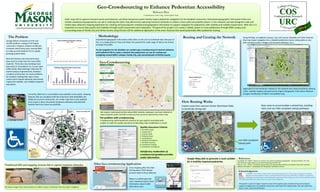
COS
URC
Undergraduate Research
Static maps fail to capture transient events and obstacles, yet these temporary events heavily impact pedestrian navigation for the disabled community. Volunteered geographic information (VGI) and
related crowdsourcing approaches can aid in resolving the static map dilemma by capturing transitory obstacles to create a more useful accessibility system. In this research, we have designed a web and
mobile data-collection mapping application for creating and assessing the crowdsourced geographic information to support navigation for pedestrians with mobility and visibility impairments. With VGI, it is
imperative to ensure data quality and reliability through careful assessment and moderation. The goal of this project is to create a reliable system to route pedestrians through GMU campus and
surrounding areas of Fairfax City and Fairfax County using VGI plus GIS for additional digitization of the area’s features that would potentially affect pedestrian routing.
This poster is part of a larger research project that explores geo-crowdsourcing and routing to
support navigation for the disabled community, with help from Fabiana Paez, Han Qin, Matt Rice,
Kevin Curtin, and Richard Medina.
20
22
24
26
28
30
32
34
2003 2004 2005 2006 2007 2008 2009 2010 2011 2012 2013
Thousandsofpeople
Census Student Enrollment in Spring
Students Enrolled
2003 - 2013
0
1
2
3
4
5
6
7
2005 2006 2007 2008 2009 2010 2011 2012 2013 2014 2015 2016
N0Buildings
Buildings Opened & Under Construction
2005 - 2016
Total = 32 new buildings
The Problem
George Mason University enrolls over
32,500 students, making it the largest
university in Virginia. Student enrollment
increases nearly every year, causing GMU
to make accommodations for its rapidly
growing student body.
New dormitories and classrooms have
been built to make room for more GMU
students. Thirty-two new buildings have
been built or renovated in an 11-year span
(2005-2016). New buildings make way for
overall campus improvements, however,
constant construction can cause problems
for students making their way to class.
Construction-related obstacles also heavily
impact the mobility- and visibility-impaired
population.
The above images show actual instances on GMU campus of obstacles that may impact navigation.
Methodology
Goodchild, M.F. (2007). "Citizens as sensors: the world of volunteered geography". GeoJournal 69 (4): 211–221.
http://kfrichter.org/crowdsourcing-material/day1/goodchild07.pdf
Rice, M., et al. (2013). “Crowdsourcing techniques for augmenting traditional accessibility maps with transitory
obstacle information.” Cartography and Geographic Information Science.
Traditional GIS and mapping systems fail to capture transient obstacles.
Geo-Crowdsourcing
We created a web-based tool that allows GMU students, employees, and local residents to
report obstacles within the GMU community that cannot be captured by a static map.
The problem with crowdsourcing
Crowdsourcing, while beneficial, presents its own qualms associated with
quality. In order for quality assurance of data (QA), data moderation is crucial.
Quality Assurance Criteria:
1. Boundary Check
2. Location (X,Y)
3. Location (text)
4. Profanity check
5. Completeness
6. Temporal Consistency
7. Attribute Accuracy
8. Contributor Training
9. Contributor # of Reports
Satisfactory moderation of
crowdsourced geodata provides
useful information.
Routing and Creating the Network
References
Geo-Crowdsourcing to Enhance Pedestrian Accessibility
Rebecca Rice
Contributors: Eric Ong, Christopher Seitz
Using ArcMap, we digitized campus, city, and county sidewalks and other features
that may impact navigation for a disabled pedestrian (stairs, steep paths or non-
ADA compliant paths, bridges and elevated walkways, etc.).
Digitization of the attributes needed for the network was made possible by utilizing
ortho- satellite imagery released by the Virginia Geographic Information Network
and geo-rectification of GMU’s accessibility map.
How Routing Works
Fastest route from Johnson Center (Northeast Side)
to Southside Dining Hall
New route to accommodate a wheelchair, avoiding
stairs and non-ADA compliant (steep) pathways
Google Maps fails to generate a route suitable
for a mobility-impaired pedestrian.
Dr. Golledge of UCSB
Currently, GMU has an accessibility map available to the public, showing
features that are compliant with the Americans with Disabilities Act
(ADA) and current construction. As a static map that is only updated
once a year, it does not portray temporary obstacles and potential
hazards that truly impact accessibility.
Other Geo-crowdsourcing Applications
Crisis mapping after the Haiti
Earthquake in 2010 helped
provide relief to those affected.
Waze is a mobile app that
uses crowdsourcing to share
information about traffic
with other users.
Acknowledgments
non-ADA compliant
(steep) path
stairs