
Recommended
More Related Content
Viewers also liked
Viewers also liked (6)
Similar to Mapping Motor Racing Venues
Recently uploaded
Recently uploaded (20)
Mapping Motor Racing Venues
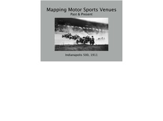
- 1. Mapping Motor Sports Venues Past & Present Indianapolis 500, 1911
- 2. • 7/22/1894 - Paris to Rouen • 11/28/1895 - Chicago->Evanston->Chicago • 9/7/1896 - Narragansett Park, Rhode Island "Auto racing began 5 minutes after the second car was built” - Henry Ford First two - public roads Narragansett Park - first closed circuit, oval race. existing horse track
- 3. Winning Duryea from the 1895 Times-Herald Race Thanksgiving day, snowed the night before won at an average speed of 7 mph, 8 hours winning car spent an hour in a blacksmith shop while J. Frank Duryea forged a replacement for a broken steering link wikipedia page on this race is problematic
- 4. History & Taxonomy • Road Courses • originally on public roads • largely moved to closed, “permanent”, road courses in the early 50s • airport courses • kart specific variants a series of accidents, some fatal, in the late 40s/early 50s triggered the move to closed circuits heyday of airport courses in the US was the early-mid 1950s, when the SCCA ran many races on SAC bomber bases
- 5. Watkins Glen haybales for crash barriers terrible accident in 1951 on Franklin Street during the race
- 6. History & Taxonomy • Oval tracks • repurposed horse tracks • late 1900s - purpose built ovals start to appear • Brooklands in the UK - 1907 • Indianapolis Motor Speedway in the US - 1909 Mapquest OpenAerial representing dual use in OHM needs relations no relation type for horse tracks right now that i’m aware of
- 7. History & Taxonomy • Oval tracks • for a brief period - 1910s & 20s - board tracks • small ovals for karts & midgets • “ovals” are not actually oval locating board tracks can be a particular challenge
- 8. Polo Grounds 1/5 mile board oval 6/5/1948, 6/8/1948 1/4 mile dirt 1940-1942 1/4 mile paved 8/28/1958-9/12/1959
- 9. Fiat Lingott • From wikipedia - uploaded by Dgtmedia - CC BY 3.0
- 10. Ingleside Track San Francisco, horse track starting 1895 auto racing track 1900-1905, 1907-1911 became a housing development in 1912 now Urbano Drive
- 11. History & Taxonomy • Drag strips • post WWII • paved - (1/8, 1/4, 1/2 mile, 1000 feet) • sand drags (300 feet) Mapquest OpenAerial 1000 feet - usually a 1/4 mile track that was shortened due to insufficient shutdown area 1/2 mile rare, but happened - Riverside International Raceway in Orange County CA 1960s this example - Dragstrip at former Indianapolis Raceway Park, now Lucas Oil raceway
- 12. History & Taxonomy • Drag strips Mapquest OpenAerial This example - Lebanon Valley Dragway (& Lebanon Valley Dragway)
- 13. History & Taxonomy • Off road • Motocross • generally stable enough to map • Rally cross • may not be stable enough to map - needs research Mapquest OpenAerial example - motocross track at Canyon Speedway, Peoria, Arizona
- 14. History & Taxonomy • Multi purpose complexes • combinations of ovals, dragstrips, road courses • complexes that include separate facilities for alternative motorsports Mapquest OpenAerial Example - IRP/Lucas Oil Raceway zoomed out a bit
- 15. History & Taxonomy Bing Imagery Miller Motorsports Park, Toole Utah
- 16. Tagging Race Tracks • highway=raceway • oneway=yes sometimes appropriate • leisure=track is for non-motorized tracks • if track is out of service, but traces are visible, use the disused: namespace in OSM (disused:highway=raceway)
- 17. Tagging Race Tracks • relation type proposal - type=circuit • valuable for multi configuration complexes • in use, could use some elaboration • start/finish variations • circuit={road, oval, dragstrip} circuit= would facilitate searching
- 18. Tagging Race Tracks • type=circuit relation • use forward/backward roles to indication direction of ways • can divide road course into segments and use traditional names • turns frequently have both names and numbers - how to represent? Lime Rock names: no-name straight west bend the left-hander big bend the uphill (aka climbing turn) the downhill (aka diving turn)
- 19. Tagging Race Tracks • temporary circuits • public roads or airports • no well defined way to do this in OSM • event data - really should use separate non-OSM DB • in OHM, just outline the circuit on top of the OSM features and use standard tagging
- 20. Tagging Race Tracks • Pit lanes • generally hot areas - recommend highway=raceway, name=Pit Lane • Return roads of dragstrips • not hot, recommend highway=service, service=driveway, name=Return Road
- 21. Tagging Race Tracks • Paddock space • highway=service, service={driveway,parking_aisle} • amenity=parking • access=permissive • name=A Paddock (or whatever the name is)
- 22. Tagging Race Tracks • If the boundary of the property can be discerned (frequently possible) • leisure=sport_centre, sport=motor • name=Name of facility/track • address, website, etc.
- 23. Open Historical Map • Uses modified OSM stack • Uses OSM tags, but with some subtle modifications • don’t use disused: tag space • instead, depend on start_date and end_date • Overpass recently installed stuff in disused generally doesn’t render with current carto stylesheets Overpass facilitates selective queries & mashups Still debugging setup; don’t have automagic update in place yet Simple temporal queries currently being considered for addition to Overpass
- 24. Open Historical Map • Currently somewhat sparsely populated • Potential to be locally densely populated • Currently no good mechanism for direct references to OSM objects
- 25. Watkins Glen • 4 different courses since 1948 • 4 variations of current course http://www.na-motorsports.com/test/Watkins.html leaflet/jquery widget because tagging is consistent, same overpass query can fetch both OHM and OSM racetrack data also pulls years from start_date & end_date for the labels need to use historic aerials or topos
- 26. Thompson Speedway • 2 ovals (1 defunct, 1 current) • 5 distinct road courses (1 current) • 2 variations of current road course http://www.na-motorsports.com/test/Thompson.html site of first closed circuit road race in the US post WWII
- 27. St Johns Grand Prix • Temporary course on airport runway • St Johns Industrial Airpark, St Johns, Arizona http://www.na-motorsports.com/test/StJohns.html in this case, used hand drawn maps supplied by race promotor
- 28. Bee Line Dragway • inactive dragstrip north of Mesa, Arizona • in OSM, • disused:highway=raceway http://www.na-motorsports.com/test/BeeLine.html
- 29. Palmer Motorsports Park • Brand spanking new road course in south central Massachusetts • highway=construction • construction=raceway
- 30. Open Tagging Issues • Dates of operation can be more complex than start_date & end_date • New York State Fairgrounds 1 mile oval • 9/10/1903, 1905, 9/18/1909-9/16/1911, 9/1919-9/01/1941, 1946, 9/10/1949- present bigger, open question of temporal representations within OHM
- 31. Open Tagging Issues • interactions of surface with dates of operation • Pine Bowl Speedway (Poestenkill NY) • clay - 7/1/1950-1951 • paved - 1952-1963 • it is reported that for a short period, the track was paved in the corners but not the straights due to a lack of funding
- 32. Sources • Various histories of old venues • History of America’s Speedways • National Speedway Directory • fairly new Ghost Tracks category of books • lots online double check everything
- 33. Sources • Local race historians • Facebook (!?) • Two groups devoted to old racing circuits • Historic aerials & topo maps Paul Norman’s github project to list historical image sources
- 34. Sources note that for USGS topos, there appears to a standard width road which is narrower than a typical racetrack. Johnston County Speedway, NC
- 35. Sources
- 36. Sources & Certainty • Need to look at sources the same way any good historian does • Need confirmation • primary vs secondary • recollections of participants long afterwards are secondary, not primary • participants may have grudges/axes to grind
- 37. Sources & Certainty • Commonly reproduced map of the 1895 Chicago race • Made 50 years after the race • Not a primary source map has a numeric key, but the keyed notes are hard to find roads north of the river in downtown Chicago don’t line up well currently trying to reconstruct the correct course, using 1893 Rand McNally map of Chicago and written accounts
- 38. Documentation • Need to document why we put things into OHM • Where do the dates and names come from? • Where was the track traced from? • http://wiki.openstreetmap.org/wiki/ Open_Historical_Map/Projects
- 39. Info • OSM/OHM handle: nfgusedautoparts • rwelty@averillpark.net • Ghost Tracks code: • github.com/OpenHistoricalMap/examples • www.na-motorsports.com/test/