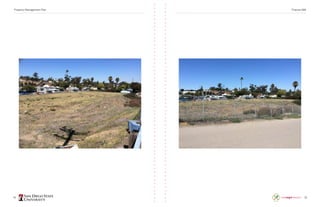
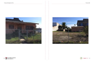
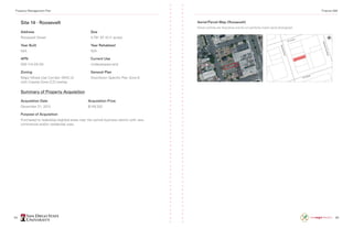
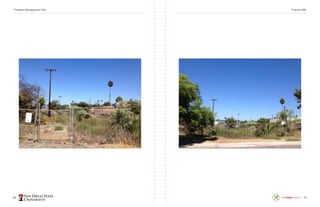
National City
Property Management Plan
Spring 2014 • Finance 498
Joshua Garman, Project Manager, Jeffrey Crocker, Hunter Graul,
Mark Gottschlich, Monica Jimenez, Carolina Conway, Joey Zaniboni,
Jack Losey, Christian Zaragoza, Andrew Funk
2 3
Table of Contents
Acknowledgments..................................................................................................4
About The Sage Project..........................................................................................4
About National City.................................................................................................5
Executive Summary................................................................................................5
Section 1: Property Management Plan...................................................................7
	 Site 1 · Former Education Center & Steamed Bean............................................................8
	 Site 2 · Kimball House....................................................................................................... 14
	 Site 3 · H&M Goodies.......................................................................................................20
	 Site 4 · Lamb’s Playhouse.................................................................................................26
	 Site 5 · McKinley Parcels...................................................................................................32
	 Site 6 · Former Days Inn....................................................................................................38
	 Site 7 · Olson Block...........................................................................................................44
	 Site 8 · Santa Fe Rail Depot...............................................................................................50
	 Site 9 · Bay Marina Right of Ways.....................................................................................54
	 Site 10 · Ace Metals..........................................................................................................60
	 Site 11 · Stein Family Farm................................................................................................66
	 Site 12 · RCP......................................................................................................................72
	 Site 13 · 38 W....................................................................................................................78
	 Site 14 · Roosevelt.............................................................................................................84
	 Site 15 · Kimball Way.........................................................................................................88
Section 2: Valuation Analyses...............................................................................95
	 921 & 929 National City Boulevard....................................................................................96
	 130 East 8th Street..........................................................................................................102
	 1231, 1237, and 1239 McKinley Avenue..........................................................................106
	 1604 E. Plaza Boulevard.................................................................................................. 110
	 Olson Block..................................................................................................................... 116
	 900 W. 23rd Street.......................................................................................................... 120
	 720 W. 23rd Street.......................................................................................................... 124
	 National City Boulevard................................................................................................... 128
	 38 W. 11th Street.............................................................................................................134
	Roosevelt.........................................................................................................................138
	 500 E. Plaza Boulevard.................................................................................................... 142
	 1808 F Avenue................................................................................................................148
	 921-923 A. Street............................................................................................................152
Section 3: Market Analyses................................................................................ 154
	 National City Market Overview.......................................................................................155
	 National City Retail Market..............................................................................................156
	 National City Hotel Market..............................................................................................158
	 National City Industrial Market........................................................................................160
Conclusion.......................................................................................................... 165
Property Management Plan Finance 498
4 5
Acknowledgments
First and foremost, we would like to thank Professors Dana Kuhn and Seth Kaplowitz
who provided us with the knowledge and direction necessary to complete a project
where we could translate academic knowledge into a real-world scenario with actual
deliverables. They approached the project with a student-led focus that allowed us to
operate independently and self-manage, which further enhanced our learning experi-
ence. Dana and Seth worked tirelessly on this project and were never more than a phone
call or an email away when assistance was necessary. Their combined years of experi-
ence and expertise in the field of real estate analysis and valuation were invaluable to
the completion of this project.
Next, we would like to thank those whose brief involvement greatly contributed to
the overall success of the Long-Range Property Management Plan (LRPMP) project.
We thank Brad Raulston, Executive Director of Development for the City of National City
and Sage Project City Liaison as well as Carlos Aguirre, Community Development Man-
ager, for taking time to meet with us and discuss the properties and answer questions
that helped us in our preparation for determining the highest and best use. We would
also like to think Alredo Ybarra, Director of Housing, Grants, and Asset Management for
the city of National City. Special thanks are also due to Trevor Hubbard, an appraiser with
Jones, Roach & Caringella, Inc., for meeting with us to review our comparable properties
and provide additional guidance in commercial real estate valuation. Finally, we would like
to thank Dawn Eisenberg for all of her help and support over the course of this project.
Sage Project Staff
Jessica Barlow, Program Director
Kristin Burbach, Graphic Design Intern
About The Sage Project
The Sage Project is a partnership between San Diego State University (SDSU) and a
city or government entity in the San Diego region. The mission of the program is to
engage students from across the University to assist the local government with projects
that address their smart growth, quality of life, and sustainability goals. Students have
the opportunity to engage in meaningful real-world projects and make positive contribu-
tions to a community in SDSU’s service area. The program’s vision is to connect SDSU
students and faculty with high-priority, high-need community projects, thereby generat-
ing interest and fresh ideas that create momentum and provide real service to the com-
munity. The Sage Project embodies the University’s commitment to serving local stu-
dents, engaging alumni, and contributing to the public good by focusing thousands of
hours of course-based student involvement with high-impact activities. The program is
based on the highly successful and award-winning Sustainable City Year Program (SCYP)
at the University of Oregon and is a part of the SCYP network. National City, California,
is the Sage Project’s 2013-2014 partner city. Participating courses come from the follow-
ing disciplines: Anthropology; Audiology; City Planning; Civil Engineering; Communica-
tion; Geography; Graphic Design; Homeland Security; International Security And Conflict
Resolution; Marketing; Political Science; Public Administration; Public Health; And
Speech, Language, and Hearing Sciences.
About National City
National City is a highly urban community of about 60,000 residents in south San Diego
County. It is the second oldest city in the county and boasts a rich history, a diverse
community, and is known as one of the most walkable cities in San Diego County.
Located just south of downtown San Diego and just north of the US-Mexico border,
the city is flanked by freeways and is home to large-scale industries. National City is
a mid-size city that faces big city challenges, and, like many municipalities, the city is
challenged to the meet community needs and new demands of sustainability.
By providing new ideas and human capacity, this partnership with the Sage Project
will help National City integrate new sustainability concepts and practices that will
improve livability.
Executive Summary
The market analyses, property valuations, and property profiles contained in this report
were created through the partnership between National City and the SDSU Sage Project
during the spring of 2014. Ten undergraduate students from various academic disciplines
participated in a special study course, led by professors Dana Kuhn and Seth Kaplowitz,
designed to provide students with an introduction to valuation theory via the develop-
ment of National City’s Long-Range Property Management Plan (LRPMP).
California’s 400 plus redevelopment agencies were officially dissolved as of February 1,
2012, after approval from the legislature as part of the 2011 Budget Act. Real properties
that were owned by the redevelopment agencies were then transferred to successor
agencies to manage redevelopment projects currently underway, make payments on
enforceable obligations, and dispose of redevelopment assets and properties. Health and
Safety Code 34191.5 requires successor agencies to prepare and submit a LRPMP,
which outlines the disposition and use of the real properties of the former redevelop-
ment agency.
The LRPMP has two main components. The first is an extensive inventory of all proper-
ties, includes parcel data, a history of acquisition, current leases, environmental studies
and contamination, an analysis of transit oriented development potential, and any previous
development proposals. The second component addresses the current use of the prop-
erty and the disposition of the property, as well as identifying how the disposition of the
property supports the advancement of the planning objectives of the successor agency.
Property Management Plan Finance 498
6 7
National City’s successor agency is currently responsible for 15 sites with a total of 32
parcels, each of which must be analyzed in a report for the California Department of
Finance. The students were responsible for analyzing documents provided by National
City, compile the information gathered and prepare a draft of National City’s LRPMP.
The students were divided into three groups of three, with one student acting as Project
Manager and analyzing a single parcel.The 16 sites were then divided amongst the three
groups with one group focusing on the downtown area, another on the Bay Marina/
Harbor District and the final group on outlying properties.
One aspect of the LRPMP, an estimate of current value, required the students in the
special study course to learn about valuation theory and perform a valuation analysis on
each property. Before completing the valuation analyses the students were first required
to study the real estate market in National City for a variety of uses, such as commercial/
retail, residential, industrial, and hospitality. The market analyses enabled the groups to
determine the highest and best use for each property, which directed the students in the
method of valuation analysis.
After conducting the market analyses and determining the proposed highest and best
use, students met with Trevor Hubbard, an appraiser with Jones, Roach & Caringella,
Inc. Trevor reviewed the comparable sales and proposed highest and best uses the stu-
dents provided and provided constructive criticisms, suggestions and directions regard-
ing the process an appraiser would use to determine the value of commercial property.
Each group then completed a sales comparison table, worked the comparable properties
in an adjustment grid and, finally, wrote a valuation analysis that described the valuation
process and issued an estimated value of each parcel.
The end result is a thorough and complete analysis of 15 sites that provides National City
with the required components of a LRPMP. The LRPMP components are made available
to the city in electronic format, which allows for any desired editing before being present-
ed to the City Council and subsequently submitted to the Department of Finance. Lastly,
city officials are now better equipped to make planning decisions by having access to
current estimates of value and analyses of the highest and best use for these assets.
Section 1: Property Management Plan
The following section contains the completed Long-Range Property Management Plan
(LRPMP). Each of the 15 sites was carefully analyzed by students and the information
required by the California Department of Finance was placed into a format similar to
successfully submitted LRPMPs from other cities. It was the goal of the students in
this project to create a LRPMP that National City officials found completed and accurate
enough to submit to the state. The state has two main requirements for the LRPMP.
First, the successor agency must submit a detailed inventory of all properties. Second,
the successor agency must report to the state the use or disposition of the property,
which has to match one of the four options given by the state.
According to the Department of Finance, the detailed inventory of parcels is required
to include nearly every aspect about the property. Current policy requires the successor
agency to report the date and purpose of acquisition, as well as the price or value at
the time of acquisition. The state also requires information regarding any current leases
or rental income, and whether or not any contractual obligations exist that dictates the
disposition of rental income. Another piece of the inventory is a history of any environ-
mental contamination, remediation or designation as a Brownfield site. Related to envi-
ronmental concerns, the state also requires the successor agency to analyze and report
on the transit orient development potential of each site. Finally, the state requires an
estimation of the current value of the property (more on the valuations of these sites
can be found in Section 2 of this report).
The second portion of the LRPMP deals exclusively with the use or disposition of each
property. For each property the state requires the successor agency to make a determi-
nation based on one of four options provided by the state. First, the successor agency
can retain the property for governmental/civic use. Second, the successor agency can
retain the property for future development. Third, the successor agency can sale the
property. Fourth, and finally, the successor agency may retain the property to fulfill any
enforceable obligations. This portion of the LRPMP required the greatest amount of
consideration by the students, as well as collaboration with officials from National City.
Ultimately, the use or dispositions of the 15 sites included in this LRPMP were deter-
mined to be either retained for government use or sold.
A checklist provided by the state enables successor agencies to ensure that all the
information required is provided and this checklist was used when the following LRPMP
was compiled. Along with the inventory of properties and use or disposition analysis,
each site’s write-up includes an aerial map and another map created by a student based
on the assessor’s parcel map. Furthermore, photographs are included for each site that
show the current state of the lot and any improvements on the lot. Following the LRPMP
in this section, the next section will provided a detailed explanation behind the estimated
value provided in the LRPMP.
Property Management Plan Finance 498
8 9
Site 1 · Former Education Center & Steamed Bean
Address
A) 921-925 National City Blvd.
B) 929 National City Blvd.
Size
A) 8,625 SF (0.20 acres)
B) 3,049 SF (0.07 acres)
Year Built
A) N/A
B) 1930
Year Rehabbed
N/A
APN
A) 556-471-03
B) 556-471-04
Current Use
A) Undeveloped land
B) Condemned building
Zoning
Sites A & B: Mixed Use Corridor (MXC-2)
with Coastal Zone (CZ) overlay
General Plan
Downtown Specific Plan Zone 5B
Summary of Property Acquisition
Acquisition Date
A) August 16, 2000
B) July 29, 2003
Acquisition Price
A) $350,000
B) $225,000
Purpose of Acquisition
Purchased to redevelop blighted area in the central business district with new
commercial and/or residential uses.
Aerial/Parcel Map (Former Education Center)
Parcel outlines are illustrative and do not perfectly match aerial photograph.
Aerial/Parcel Map (Steamed Bean)
Parcel outlines are illustrative and do not perfectly match aerial photograph.
Property Management Plan Finance 498
10 11
Property Management Plan Finance 498
12 13
Site 1 · Former Education Center & Steamed Bean
History/Background
Parcel 556-471-03 (A): Acquired by the Community Development Commission from the
Wenig Herbert Trust on August 16, 2000. The property, located on National City Blvd.
between 9th
St. and Plaza Blvd. was previously an education center that helped engage
the community with opportunities in higher education. After 13 years as a vacant prop-
erty, the Wenig family sold the property to the CDC. In 2001 the education center was
demolished by Whillock Contract and the property has remained undeveloped since.
Parcel 556-471-04 (B): Acquired by the Community Development Commission from
Patricia Sanders on July 29, 2003. This parcel is contiguous with the former education
center property and the CDC was approached by a representative of the subject proper-
ty while pursuing the purchase of the education center. Negotiations for the property
purchase took place but no agreements were finalized. In mid-2002, negotiations were
renewed and a purchase price of $225,000 was negotiated without the use of an appraiser.
Environmental Contamination and Related Studies or Remediation
There is no known environmental contamination at the site.
Estimate of Lease/Rental/Other
N/A
Contractual Requirements for Use of Income/Revenue
N/A
Transit Oriented Development Potential
Located a mere half-mile away from the 8th
Street trolley station and within a 1 block
radius of 3 bus stops supporting 5 different routes, the site is a prime location to support
transit oriented development. The trolley offers transit access to popular San Diego
attractions including Old Town, Mission Valley, Fashion Valley, Petco Park, and Qual-
comm stadium. The close proximity to the trolley line makes it a convenient location for
to access other parts of San Diego. Furthermore, the site is situated in the central busi-
ness district and is within walking distance from retail, recreational and civic services.
Any development at this site should enhance the creation of a walkable and transit
oriented neighborhood.
Previous Development Proposals and Activity
No development proposals have been made that met zoning and municipal
code requirements.
Agency’s Planning Objectives
Encourage development of mixed-use residential and commercial space to remove
blight and enhance the central business district.
Use/Disposition of the Property
The successor agency will likely sell the properties for future development.
Current Estimated Value
Direct comparison with sales of similar land suggests a value of $235,000 as of May
1st, 2014. The last professional appraisals to be conducted at either subject property
are unknown.
Property Management Plan Finance 498
14 15
Site 2 · Kimball House
Address
921-923 A Avenue
Size
8,712 SF (0.20 acres)
Year Built
1868
Year Rehabbed
Minor rehabilitations in 2003, 2004,
and 2008
APN
556-472-16
Current Use
Historical museum
Zoning
Medium Density Residential (RM-1)
with Coastal Zone overlay
General Plan
Downtown Specific Plan Zone 11
Summary of Property Acquisition
Acquisition Date
February 9, 1977
Acquisition Price
$324,000
Purpose of Acquisition
Purchased to protect the property as a locally designated historic building.
Aerial/Parcel Map (Kimball House)
Parcel outlines are illustrative and do not perfectly match aerial photograph.
Property Management Plan Finance 498
16 17
Property Management Plan Finance 498
18 19
Site 2 · Kimball House
History/Background
Frank Kimball, a founder of National City, built the home in 1868. The house boasted of
being the first modern house in San Diego with amenities such as a bath tub with run-
ning water. Originally located at 21 W. Plaza Boulevard, the building was moved to its
current location on A Street near Brick Row in Heritage Square in 1980 to protect it from
being demolished. The cost of moving the building and the cost for the land on A Street
are unknown.
Environmental Contamination and Related Studies or Remediation
There is no known environmental contamination at the site.
Estimate of Lease/Rental/Other
The City of National City has a negative cash flow associated with a 15 year lease with
the Historical Society. The lease expires August 19, 2023 and provides the first floor of
the Kimball House to the Historical Society for use as a museum. There is another poten-
tial lease providing the second floor to Janice Martinell of the Historical Society for use
a living space while serving as caretaker of the Kimball House.
Contractual Requirements for Use of Income/Revenue
Any funds received from the operation of the museum are used to pay for utilities and
maintenance of the house.
Transit Oriented Development Potential
Located a mere half-mile away from the 8th
Street trolley station and within a 1 block
radius of 4 bus stops supporting 5 different routes, the site is a prime location to support
transit oriented development. The trolley offers transit access to popular San Diego
attractions including Old Town, Mission Valley, Fashion Valley, Petco Park, and Qual-
comm stadium. The close proximity to the trolley line makes it a convenient location for
to access other parts of San Diego. Furthermore, the site is situated in the central busi-
ness district and is within walking distance from retail, recreational and civic services.
Any development at this site should enhance the creation of a walkable and transit ori-
ented neighborhood.
Previous Development Proposals and Activity
No development proposals have been made.
Agency’s Planning Objectives
Encourage cultural and educational programs designed to increase understanding and
appreciation of the history of National City through the operation of a historical museum.
Use/Disposition of the Property
The successor agency will retain the property for civic purposes.
Current Estimated Value
Direct comparison with sales of similar land suggests a value of $235,000 as of May
1st, 2014. The last professional appraisals to be conducted at either subject property
are unknown.
Property Management Plan Finance 498
20 21
Site 3 · H&M Goodies
Address
130 E. 8th
Street
Size
28,750 SF (0.66 acres)
Year Built
1960
Year Rehabbed
N/A
APN
556-474-26
Current Use
Freestanding Retail Location
Zoning
Major Mixed Use Corridor (MXC-2)
with Coastal Zone (CZ) overlay
General Plan
Downtown Specific Plan Zone 9
Summary of Property Acquisition
Acquisition Date
April 25, 2003
Acquisition Price
$1,085,000
Purpose of Acquisition
Purchased to redevelop blighted area in the central business district with new
commercial and/or residential uses.
Aerial/Parcel Map (H&M Goodies)
Parcel outlines are illustrative and do not perfectly match aerial photograph.
Property Management Plan Finance 498
22 23
Property Management Plan Finance 498
24 25
Site 3 · H&M Goodies
History/Background
A purchase price of $1,085,000 was agreed upon contingent on the CDC obtaining free
and clear title and environmental clearances. The price was inclusive of all costs including
relocation, loss of goodwill, and the value of all fixtures and equipment.
Environmental Contamination and Related Studies or Remediation
There is no known environmental contamination at the site. However, the site was
subjected to a Fire Code inspection in 2011 and was sited with multiple code violations,
including the possibility of lead paint.
Estimate of Lease/Rental/Other
The CDC entered into a 6 month lease with the Schoenfeld Family Trust on May 1, 2003
to continue the operation of a retail location. The lease is now operated on a month-to-
month basis and generates an income of $2,500.
Contractual Requirements for Use of Income/Revenue
$2,500 per month is received for the operating lease and is placed into an SA account.
Transit Oriented Development Potential
Located less than a half-mile away from the 8th
Street trolley station and within a 4
block radius of 4 bus stops supporting 5 different routes, the site is a prime location
to support transit oriented development. The trolley offers transit access to popular
San Diego attractions including Old Town, Mission Valley, Fashion Valley, Petco Park,
and Qualcomm stadium. The close proximity to the trolley line makes it a convenient
location for to access other parts of San Diego. Furthermore, the site is situated in the
central business district and is within walking distance from retail, recreational and civic
services. Any development at this site should enhance the creation of a walkable and
transit oriented neighborhood.
Previous Development Proposals and Activity
The Social Security Administration had expressed interest in the site for the construction
of new office space in 2010 but no agreements were made.
Agency’s Planning Objectives
Encourage development of mixed-use residential and commercial space to remove blight
and enhance the central business district.
Use/Disposition of the Property
The successor agency will likely sell the property for future development.
Current Estimated Value
Direct comparison with sales of similar land suggests a value of $575,000 as of May 1st
,
2014. However, students with basic instruction in valuation theory created these value
estimates. While believed to be credible, the conclusions are student opinions, not pro-
fessional appraisals. The last professional appraisal was conducted in 2010 and the site
was valued at $605,000.
Property Management Plan Finance 498
26 27
Site 4 · Lamb’s Playhouse
Address
500 E. Plaza Boulevard
Size
16,990 SF (0.39 acres)
Year Built
Unknown
Year Rehabbed
1978
APN
556-560-39-00
Current Use
Vacant theatrical performance space
Zoning
Major Mixed Use Development (MXD-2)
General Plan
Downtown Specific Plan Zone 9
Summary of Property Acquisition
Acquisition Date
May 26, 2005
Acquisition Price
$970,000
Purpose of Acquisition
Purchased to redevelop blighted area in the central business district with new or
rehabilitated performing arts center.
Aerial/Parcel Map (Lamb’s Playhouse)
Parcel outlines are illustrative and do not perfectly match aerial photograph.
Property Management Plan Finance 498
28 29
Property Management Plan Finance 498
30 31
Site 4 · Lamb’s Playhouse
History/Background
The property was originally build and used as a Christian Science Church building.
A small non-profit theater production company, Lamb’s Players Incorporated, purchased,
renovated and used the facility as a venue for 119 productions from 1978-1994. The old
arena-style theater accommodated a maximum occupancy of 172 people and its back-
stage rooms doubled as Lamb's Players administrative offices. On May 26 2005, National
City purchased the Playhouse from Lamb’s Players Incorporated. A due diligence report
in February of 2006 estimated it would cost the CDC an additional $640,000 to bring the
building up to code. Due to the high cost of rehabilitation, the property has remained
vacant since 2005.
Environmental Contamination and Related Studies or Remediation
There is no known environmental contamination at the site. However, the building was
subjected to a code inspection in 2006 and was cited with multiple code violations,
including the possibility of lead paint and asbestos.
Estimate of Lease/Rental/Other
N/A
Contractual Requirements for Use of Income/Revenue
N/A
Transit Oriented Development Potential
Located less than one mile away from the 8th
Street trolley station and within a 4
block radius of 4 bus stops supporting 6 different routes, the site is a good location
to support transit oriented development. The trolley offers transit access to popular
San Diego attractions including Old Town, Mission Valley, Fashion Valley, Petco Park,
and Qualcomm stadium. The close proximity to the trolley line makes it a convenient
location for to access other parts of San Diego. Furthermore, the site is situated near
the central business district and is within walking distance from retail, recreational and
civic services. Any development at this site should enhance the creation of a walkable
and transit oriented neighborhood.
Previous Development Proposals and Activity
Proposals to renovate by non-profits to keep the building operational have been made,
yet improvements were deemed too costly. Renovation estimates ranged from
$1,000,000 to $3,000,000.
Agency’s Planning Objectives
Encourage increased quality of life within the city by providing a space for the performing
arts and other cultural events.
Use/Disposition of the Property
The successor agency will likely sell the property for future development.
Current Estimated Value
Due to the high estimated cost to rehabilitate the property, a residual analysis based
on comparable retail space suggests a negative value. A direct comparison with sales
of similar land suggests a value of $480,000 as of May 1st
, 2014. The last professional
appraisal was conducted in 2006 and the site was valued at approximately $900,000.
Property Management Plan Finance 498
32 33
Site 5 · McKinley Parcels
Address
A) 1231 McKinley Avenue
B) 1237 McKinley Avenue
C) 1239 McKinley Avenue
Size
A) 2,613 SF (0.06 acres)
B) 3,049 SF (0.07 acres)
C) 3,049 SF (0.07 acres)
Year Built
N/A
Year Rehabbed
N/A
APN
A) 559-022-05
B) 559-022-07
C) 559-022-08
Current Use
All properties on site are
undeveloped land
Zoning
Medium Industrial (IM)
with Coastal Zone (CZ) overlay
General Plan
Harbor District
Summary of Property Acquisition
Acquisition Date
A) October 22, 1999
B) July 23, 1998
C) July 8, 1998
Acquisition Price
A) $50,060
B) $82,660
C) $118,199
Purpose of Acquisition
Purchased to create an assemblage suitable for redevelopment of a blighted area.
Aerial/Parcel Map (McKinley Parcels)
Parcel outlines are illustrative and do not perfectly match aerial photograph.
Property Management Plan Finance 498
34 35
Property Management Plan Finance 498
36 37
Site 5 · McKinley Parcels
History/Background
The Community Development Commission purchased these parcels in 1998 and 1999.
There was a house on the two contiguous parcels. Shortly after the site was purchased
by the CDC the residents left and the house was demolished. Since then the lots have
remained vacant. The non-contiguous parcel was vacant when the CDC purchased
the property and has remained vacant. The Public Utilities Department for the City of
National City has an easement on the two contiguous parcels in which they store city
equipment.
Environmental Contamination and Related Studies or Remediation
A Phase I ESA was conducted on all three parcels in 2010 and identified proximal sources
of potential soil and groundwater contamination that represent a recognized environmen-
tal condition. The Phase I recommendation was to perform a Phase II subsurface inves-
tigation to provide information for construction contingency planning if required for future
development activities. No environmental remediation has taken place. However, the site
is located in the CDC’s former Brownfield Grant Redevelopment Area.
Estimate of Lease/Rental/Other
N/A
Contractual Requirements for Use of Income/Revenue
N/A
Transit Oriented Development Potential
Despite being less than one-half mile from the 8th
Street trolley station, the lot sizes
and zoning of this site provide little indication that the site is suitable for transit oriented
development.
Previous Development Proposals and Activity
No development proposals have been made.
Agency’s Planning Objectives
Encourage increased quality of life within the city by providing a space for the performing
arts and other cultural events.
Use/Disposition of the Property
The successor agency will retain the lot for governmental use.
Current Estimated Value
Direct comparison with sales of similar land suggests a value of $85,000 as of May
1st
, 2014 for the two contiguous parcels with the remainder parcel at a nominal value.
The last professional appraisal to be conducted at the site is unknown.
Property Management Plan Finance 498
38 39
Site 6 · Former Days Inn
Address
1604 E. Plaza Avenue
Size
46,609 SF (1.07 acres)
Year Built
N/A
Year Rehabbed
N/A
APN
A) 559-022-05
B) 559-022-07
C) 559-022-08
Current Use
Undeveloped land
Zoning
Major Mixed Use Corridor (MXC-2)
General Plan
Downtown Specific Plan Zone 5B
Summary of Property Acquisition
Acquisition Date
2004
Acquisition Price
$3,77 5,000
Purpose of Acquisition
Purchased to redevelop blighted area into a residential housing project.
Aerial/Parcel Map (Former Day’s Inn)
Parcel outlines are illustrative and do not perfectly match aerial photograph.
Property Management Plan Finance 498
40 41
Property Management Plan Finance 498
42 43
Site 6 · Former Days Inn
History/Background
This property was a functioning hotel until it closed in the early 2000s, leaving a blight-
ed and abandoned building. Under a put-option agreement with the CDC, National City
Hotels acquired the property in 2004 from Rex Investments for $3,775,000 with the
intent to develop mixed-use residential units with the assistance of government entitle-
ments. When National City Hotels was unable to obtain the government entitlements
and the adjacent vacant property, they exercised the put-option agreement with the
CDC. The prices of these sales were based on valuations that included the value of an
operable hotel. Numerous development proposals and agreements were entered into
but none materialized in redevelopment.
Environmental Contamination and Related Studies or Remediation
There is no known environmental contamination at the site.
Estimate of Lease/Rental/Other
N/A
Contractual Requirements for Use of Income/Revenue
N/A
Transit Oriented Development Potential
Despite zoning that permits mixed-use and high density residential, the site does not
suit transit oriented development because it is located outside of the central business
district and is 1.5 miles from the nearest trolley station. While there is a transit stop
174ft. from the site, it is only serviced by one transit line. Its distance from the trolley
line and its location outside of the CBD indicate there is little opportunity for transit
oriented development.
Previous Development Proposals and Activity
A Purchase and Sale Agreement between Palm Plaza Associates and the CDC was
entered into in November of 2009 for a sale amount of $1,823,000 for the purpose on
developing 72 for-sale residential units. The City Council of National City approved a
Planned Development Permit for a 72-unit condominium development on 15 December
2009 and the CDC authorized the Chairman to execute the Purchase and Sale Agree-
ment on 15 January 2010. The sale was contested by the owner of a Thrifty Gas Station
contiguous to the Palm Plaza Associates property. Palm Plaza Associates sold their front-
age on Plaza Blvd. to the owners of the Thrifty in order to secure the deal with the CDC.
However, the recession had greatly affected the appraised value of the property, which
led to an amendment of the PSA in June of 2011 reflecting a new value of $690,000.
Prior to the completion of the sale and beginning of construction redevelopment agen-
cies were dissolved, which stopped the redevelopment of the site.
Agency’s Planning Objectives
Encourage development of high density residential to provide affordable housing to
the city.
Use/Disposition of the Property
The successor agency will likely sell the property for future development.
Current Estimated Value
Direct comparison with sales of similar land suggests a value of $790,000 as of May
1st
, 2014. The last professional appraisal was conducted in 2011 and the site was valued
at $690,000.
Property Management Plan Finance 498
44 45
Site 7 · Olson Block
Address
A) Cleveland Avenue
B) 2300 Cleveland Avenue
C) 830 West 23rd
Street
D) 835 West 24th
Street
E) 801 Bay Marina Drive
Size
A, B, C) 28,750 SF (0.66 acres)
D) 8,394 SF (0.19 acres)
E) 20,037 SF (0.46 acres)
Year Built
N/A
Year Rehabbed
N/A
APN
A) 559-117-04
B) 559-117-05
C) 559-117-12
D) 559-117-06
E) 559-117-07
Current Use
Undeveloped land
Zoning
Sites A, B, C: Heavy Industrial (IH)
Sites D & E: Multi-Use Commercial-
Residential (MCR-1) with Coastal Zone
(CZ) overlay
General Plan
Bayfront/Marina Gateway, Westside
Specific Plan
Summary of Property Acquisition
Acquisition Date
A, B, C, D) January 27, 1999
E) August 3, 1994
Acquisition Price
A, B, C) $780,000
D) $430,000
E) Unknown (Property acquired through
bankruptcy)
Purpose of Acquisition
Assemblage for large scale commercial and light industrial redevelopment.
Aerial/Parcel Map (Olson Block)
Parcel outlines are illustrative and do not perfectly match aerial photograph.
Property Management Plan Finance 498
46 47
Property Management Plan Finance 498
48 49
Site 7 · Olson Block
History/Background
National City approved a General Plan in 1996 that included allowances for the Port
District to develop a marina and expand recreational uses adjacent to Pepper Park.
The Community Development Commission acquired the subject site, and others in the
immediate area, to encourage tourist-oriented commercial development on the south
side of Bay Marina Drive and light industrial uses to the north. In September of 2009
the National City adopted a vacation of the alley-way south of West 23rd
Street and
north of Bay Marina Drive to encourage development and implementation of the Harbor
District Specific Plan.
Parcels 559-117-04, 05, 12 (A,B,C): Acquired by the Community Development Commis-
sion from Tideland properties on January 27th, 1999 for $780,000. The three parcels are
situated on 23rd
Street, Bay Marina Drive and Cleveland Avenue. At the time of purchase
the property was improved with one double-Quonset style industrial building, one metal
Butler style industrial building and a two-story concrete office building. The 16,430 SF of
improved area was demolished in 1999 to prepare the site for future redevelopment.
Parcel 559-117-06 (D): Acquired by the Community Development Commission from
Robert D. Young on January 27th, 1999 for $430,000. This parcel is situated at the
southeast corner of Harrison and 23rd
street. At the time of purchase the property
was improved with an 8,506 SF industrial building until being demolished in 1999.
Parcel 559-117-07 (E): Acquired by the Community Development Commission from the
Bankruptcy estate of Remo Tontini on August 2, 1994. The acquisition price is unknown.
The site is situated on the northwest corner of Harrison Avenue and Bay Marina Drive.
At the time of purchase there were four connected main buildings with additional out-
door storage spaces, which were demolished in 1999.
Environmental Contamination and Related Studies or Remediation
According to the Environmental Business Solutions, Inc. report in September 2001.
The subject site had three wells that were installed at the property. The wells were
sampled and analyzed for volatile organic compounds (VOC’s), semi-volatile organic
compounds (SVOC’s), methyl tertiary ether (MTBE), poly-nuclear aromatic hydrocar-
bons (PAHs), and metals listed in Title 22 of the California Code of Regulation (CCR).
The sampling was documented in a February 8, 1999, groundwater monitoring report
by Ninyo & Moore.
Estimate of Lease/Rental/Other
N/A
Contractual Requirements for Use of Income/Revenue
N/A
Transit Oriented Development Potential
The 24th
Street trolley station is approximately .4 miles from the subject property.
It provides 156 free parking spaces with a north-south trolley line that runs seven days
a week. The trolley offers transit access to popular San Diego attractions including Old
Town, Mission Valley, Fashion Valley, Petco Park, and Qualcomm stadium. The close
proximity to the trolley line makes it a convenient location to access other parts of San
Diego, indicating the site has potential for transit oriented development. Additionally,
transit oriented development would support the agency’s planning objective of develop-
ing commercial and recreational uses by focusing on increased tourism.
Previous Development Proposals and Activity
The Community Development Commission was in negotiations with Marina Gateway
Development Company to develop a commercial project on the subject site. The goal
and strategy of development was to provide retail and tourism uses that would comple-
ment and support the existing industrial development and other new commercial devel-
opments in the vicinity. The subject property was being actively marketed until the dis-
banding of the redevelopment agency.
Agency’s Planning Objectives
Encourage development of retail, commercial, and light industrial uses to increase
tourism to the city.
Use/Disposition of the Property
The successor agency will likely sell the property for future development.
Current Estimated Value
Direct comparison with sales of similar land suggests a value of $2,250,000 as of May
1st
, 2014.
The last known professional appraisals have been completed as follows:
APN 559-117-05 (B): Land Value of $250,000 as of October 9, 2003. Appraised by
Keagy Real Estate.
APN 559-117-06 (D): Real Property Value of $408,000 as of January 15, 1998.
Appraised by Hendrickson Appraisal Company.
APN 559-117-04, 12 (A & C): Real Property Value of $735,000 as of February 15, 1998.
Appraised by Hendrickson Appraisal Company.
APN 559-117-07 (E): Real Property Value of $465,000 as of November 22, 1989.
Appraised by G.R. Bill Company.
Property Management Plan Finance 498
50 51
Site 8 · Santa Fe Rail Depot
Address
900 W. 23rd
Street
Size
49,223 SF (1.13 acres)
Year Built
1882
Year Rehabbed
1998
APN
559-040-43-01
Current Use
Historical museum and community
gathering center
Zoning
Multi-Use Commercial-Residential
(MCR-1) with Coastal Zone (CZ) overlay
General Plan
Westside Specific Plan
Summary of Property Acquisition
Acquisition Date
August 8, 1995
Acquisition Price
$678,000
Purpose of Acquisition
Purchased to restore registered historic structure as a museum.
Aerial/Parcel Map (Santa Fe Rail Depot)
Parcel outlines are illustrative and do not perfectly match aerial photograph.
Property Management Plan Finance 498
52 53
Site 8 · Santa Fe Rail Depot
History/Background
The Santa Fe Rail Depot was built in 1882 and was the first rail station in the San Diego
region to be integrated into the transcontinental rail system. The depot was designed
with an Italianate style of architecture and lies within its original location. The Santa Fe
Rail Depot is the oldest railroad-related structure in San Diego County and is a nationally
registered historic site.
In 1998 the Community Development Commission acquired the depot so it could remain
a historic site under public ownership. The CDC made numerous improvements to restore
the depot to the original design. The rail depot is currently being maintained and operat-
ed by the San Diego Electric Railway Association, which is a non-profit corporation dedi-
cated to preserving the historic streetcar systems in the County. The depot acts as both
a museum, highlighting the historic role of the railroad system in developing San Diego,
as well as a community gathering center.
Environmental Contamination and Related Studies or Remediation
There is no known environmental contamination at the site.
Estimate of Lease/Rental/Other
Two office rental units on the second story generate $280 monthly. The lease with MRW
Inc. is a separate lease from the lease agreement between the CDC and the SDERA that
was entered into on September 2, 2008. In 2011 that lease was renewed and allowed up
to 4 additional 3-year terms.
Contractual Requirements for Use of Income/Revenue
Rental income is used to pay utilities and insurance for the museum.
Transit Oriented Development Potential
Despite being located one-half mile from the nearest trolley stop, the current use
and designation of the property indicates the site is not suitable for transit oriented
development.
Previous Development Proposals and Activity
Various uses have been proposed for the Rail Depot including a restaurant, office space,
industrial space, and a storage space. As a vacant property there was a proposal for the
development of an owner occupied or build to suit industrial office with the possibility of
a second building with a café/restaurant serving breakfast and lunch to the surrounding
industrial area. As an improved property there was consideration of community uses
such as a museum or community meeting rooms and adult education.
Agency’s Planning Objectives
Encourage cultural and educational programs designed to increase understanding and
appreciation of the history of National City through the operation of a historical museum.
Use/Disposition of the Property
The successor agency will retain the property for civic purposes.
Current Estimated Value
Direct comparison with sales of other historic sites suggests a value of $1,375,000 as
of May 1st
, 2014. The last professional appraisal conducted is unknown.
Property Management Plan Finance 498
54 55
Site 9 · Bay Marina Right of Ways
Address
A) Cleveland Avenue
B) Cleveland Avenue
C) Cleveland Avenue
D) Cleveland Avenue
E) Cleveland Avenue
F) Cleveland Avenue
Size
A) 2,839 SF (0.07 acres)
B) 1,708 SF (0.04 acres)
C) 5,924 SF (0.14 acres)
D) 23,087 SF (0.53 acres)
E) 23,522 SF (0.54 acres)
F) 3,974 SF (0.09 acres)
Year Built
N/A
Year Rehabbed
N/A
APN
A) 559-117-19
B) 559-117-21
C) 559-117-23
D) 559-117-25
E) 559-117-27
F) 559-160-29
Current Use
These small parcels are acting as
buffers and being used as a bike path,
sidewalk, and streetscape
Zoning
All parcels are located in the Coastal
Zone (CZ)
General Plan
Harbor District Specific Plan
Summary of Property Acquisition
Acquisition Date
A) May 21, 2008
B) October 31, 2001
C) October 31, 2001
D) October 31, 2001
E) March 13, 2001
F) October 31, 2001
Acquisition Price
Not available
Purpose of Acquisition
Assemblage for large scale commercial development.
Aerial/Parcel Map (Bay Marina Right of Ways)
Parcel outlines are illustrative and do not perfectly match aerial photograph.
Property Management Plan Finance 498
56 57
Property Management Plan Finance 498
58 59
Site 9 · Bay Marina Right of Ways
History/Background
The original assembled parcel was composed of 4.63 acres, which were obtained
through eminent domain proceedings. It was then developed into the Marina Gateway
Hotel, a facility with approximately 150 rooms, 8,000 square foot of conference facilities,
a 4,000 square foot restaurant and 10,000 square feet of office space. After the redevel-
opment the CDC was left with six remainder parcels surrounding the development.
Three of the subject parcels are located to the north of the hotel (A, B & F) and are used
as sidewalk and streetscape areas. The other three parcels to the south of the hotel (C,
D & E) are used for public purposes and were developed into a bike path and walkway.
The parcels to the south also act as a buffer between the hotel development and federal
marsh land.
Environmental Contamination and Related Studies or Remediation
Adjacent parcels to the site have had numerous environmental studies indicating a
moderate amount of environmental contamination that was remediated in the early
1990s. The APN’s of the subject site are not mentioned in any of the Phase I, Phase II,
or groundwater and geotechnical reports directly, however the adjacent parcels were
contaminated by the previous presence of one underground storage tank (UST) and four
above ground storage tanks (AST). The AST and the USTs were removed in the early
1990s and KMS Environmental excavated approximately 200 cubic yards of soil. Remedi-
ation efforts were successful and did not hinder the development of the Marina Gateway
Hotel. It is believed the subject site no longer contains any environmental contamination.
Estimate of Lease/Rental/Other
N/A
Contractual Requirements for Use of Income/Revenue
N/A
Transit Oriented Development Potential
Despite being less than one-half mile from the 24th
Street trolley station, the lot
sizes and zoning of this site provide little indication that the site is suitable for transit
oriented development.
Previous Development Proposals and Activity
No development proposals have been made.
Agency’s Planning Objectives
Encourage development of retail and commercial uses to increase tourism to the city.
Use/Disposition of the Property
The successor agency will retain the property for civic and governmental purposes.
Current Estimated Value
Due to the size and location of these parcels, the subject site is considered to have
nominal value. The last professional appraisal to be conducted at the site is unknown.
Property Management Plan Finance 498
60 61
Site 10 · Ace Metals
Address
720 W. 23rd
Street
Size
55,321 SF (1.27 acres)
Year Built
N/A
Year Rehabbed
N/A
APN
559-118-02-00
Current Use
Undeveloped land
Zoning
Heavy Industrial (IH) with Coastal Zone
(CZ) overlay
General Plan
Westside Specific Plan
Summary of Property Acquisition
Acquisition Date
January 2, 2001
Acquisition Price
$1,104,000
Purpose of Acquisition
Purchased to redevelop blighted area with new commercial and industrial uses.
Aerial/Parcel Map (Ace Metals)
Parcel outlines are illustrative and do not perfectly match aerial photograph.
Property Management Plan Finance 498
62 63
Property Management Plan Finance 498
64 65
Transit Oriented Development Potential
The 24th
Street trolley station is approximately.4 miles from the subject property. The 24th
street trolley station offers 156 free parking spaces with a north-south trolley line that
runs seven days a week. The trolley offers transit access to popular San Diego attrac-
tions including Old Town, Mission Valley, Fashion Valley, Petco Park, and Qualcomm sta-
dium. The close proximity to the trolley line makes it a convenient location for to access
other parts of San indicating the site has potential for transit oriented development. Addi-
tionally, transit oriented development would support the agency’s planning objective of
developing commercial and recreational uses by focusing on increased tourism.
Previous Development Proposals and Activity
The Community Development Commission was in negotiations with Marina Gateway
Development Company to develop a commercial project on the subject site. The goal
and strategy of development was to provide retail and tourism uses that would comple-
ment and support the existing industrial development and other new commercial devel-
opments in th
e vicinity. The subject property was being actively marketed until the dis-
banding of the redevelopment agency.
Agency’s Planning Objectives
Encourage development of retail, commercial, and light industrial uses to increase
tourism to the city.
Use/Disposition of the Property
The successor agency will likely sell the property for future development.
Current Estimated Value
Direct comparison with sales of similar land suggests a value of $2,200,000 as of
May 1st
, 2014. The last professional appraisal conducted is unknown.
Site 10 · Ace Metals
History/Background
National City approved a General Plan in 1996 that included allowances for the Port
District to develop a marina and expand recreational uses adjacent to Pepper Park.
The Community Development Commission acquired the subject site and others in the
immediate area to encourage tourist-oriented commercial development on the south
side of Bay Marina Drive and light industrial uses to the north. In September of 2009
the National City adopted a vacation of the alley-way south of West 23rd
Street and north
of Bay Marina Drive to encourage development and implementation of the Harbor District
Specific Plan.
In October 1998 the CDC filed a complaint of eminent domain on the subject property.
A judgment in favor of the CDC was made and after a payment in January 2001 the prop-
erty was granted to the CDC. Shortly after the change in ownership, the buildings previ-
ously used by Ace Metals were demolished and the property was used for parking by
automotive dealerships. Currently the subject site is vacant and awaiting redevelopment.
Environmental Contamination and Related Studies or Remediation
The subject site has undergone six environmental studies according to a report published
in 2001. These studies include: two Phase I ESAs and four Phase II ESAs. There were
approximately 66 soil borings drilled and sampled including 10 soil vapor sample points.
The areas/features of concern were a former above ground storage tank, a former
underground storage tank, a former hydraulic baler, and elevated hydrocarbon concentra-
tion in surface soils. A Revised Property Mitigation Plan (RPMP), dated April 7, 2006,
was prepared for the CDC. The RPMP described the excavation and disposal of soil
at the property.
Estimate of Lease/Rental/Other
N/A
Contractual Requirements for Use of Income/Revenue
N/A
Property Management Plan Finance 498
66 67
Site 11 · Stein Family Farm
Address
A) F Avenue
B) E Avenue
C) 1808 F Avenue
D) 1845 E Avenue
Size
A) 20,473 SF (0.47 acres)
B) 28,750 SF (0.66 acres)
C) 15,681 SF (0.36 acres)
D) 7,840 SF (0.18 acres)
Year Built
A-C) May 21, 1881
D) Unknown
Year Rehabbed
N/A
APN
A) 560-232-02
B) 560-232-04
C) 560-232-06-00
D) 560-232-05
Current Use
Historical farm used for guided tours
and educational purposes
Zoning
A-C) Open Space (OS)
D) Medium Density Residential (RM-1)
General Plan
Westside Specific Plan
Summary of Property Acquisition
Acquisition Date
A-D) July 30, 1992
Acquisition Price
A-D) $450,000
Purpose of Acquisition
Purchased to protect the property as a locally significant open space
Aerial/Parcel Map (Stein Family Farm)
Parcel outlines are illustrative and do not perfectly match aerial photograph.
Property Management Plan Finance 498
68 69
Property Management Plan Finance 498
70 71
Previous Development Proposals and Activity
In 1992, descendants the Steins were approached by a developer interested in building
apartments on the site. After a public awareness campaign to “Save the Farm,”
the property was sold to National City to retain the property as a museum.
Agency’s Planning Objectives
Encourage cultural and educational programs designed to increase understanding and
appreciation of the history of National City through the operation of a historical museum
and working farm.
Use/Disposition of the Property
The successor agency will retain the properties for civic purposes.
Current Estimated Value
Direct comparison with sales of similar properties suggests a value of $600,000 as of
May 1st
, 2014. The last professional appraisal to be conducted at the site is unknown.
Site 11 · Stein Family Farm
History/Background
Charles Stein purchased the property from E. Thelen in 1900 and the Stein Family
occupied it until 1992. Although there is debate about the origins of the 1808 F Avenue
house, it is known that Charles Stein did make many modifications to the property over
time. The barn, built by Mr. Fuson of National City, was thriftily made with varying sizes
of lumber, some of which were clearly recycled from earlier buildings. Ownership of the
home passed from Stein’s daughters, Frieda and Maria, to a niece, Madelyn, and finally
their grandnephew Steven. The Community Development Commission acquired the
Stein Farm properties in 1992 and it is now being operated as a Living History Museum.
(History taken from http://thesteinfamilyfarm.org/history/historyThree.html)
Environmental Contamination and Related Studies or Remediation
There is no known environmental contamination at the site.
Estimate of Lease/Rental/Other
The last fully executed Operating Agreement for operation of the farm and museum was
signed in 1992 and is currently on hold over.
Contractual Requirements for Use of Income/Revenue
Any revenues collected from the unit at 1835 E Avenue will continue to be used to sup-
port the operation of Stein Farm and the museum.
Transit Oriented Development Potential
Despite being less than one mile from the 24th
Street trolley station the zoning and histor-
ic designation of this site provide little indication that the site is suitable for transit orient-
ed development.
Property Management Plan Finance 498
72 73
Site 12 · RCP
Address
National City Boulevard & 32nd
Street
Size
58,370 SF (1.34 acres)
Year Built
N/A
Year Rehabbed
N/A
APN
562-321-08
Current Use
Undeveloped land
Zoning
Commercial Automotive-Planned
Development (CA-PD) with Coastal
Zone (CZ) overlay
General Plan
Multi-use General Commercial
Summary of Property Acquisition
Acquisition Date
1991
Acquisition Price
$737,000
Purpose of Acquisition
Purchased to develop commercial automotive business
Aerial/Parcel Map (RCP)
Parcel outlines are illustrative and do not perfectly match aerial photograph.
Property Management Plan Finance 498
74 75
Property Management Plan Finance 498
76 77
Site 12 · RCP
History/Background
The Community Development Commission purchased the land from Allan and La
Verne Olson in 1991. The land remains vacant with no prior history of development
or improvement.
Environmental Contamination and Related Studies or Remediation
There is no known environmental contamination at the site.
Estimate of Lease/Rental/Other
Currently the property is leased to Frank Motors at $6,334 per month and is under
Exclusive Negotiating Agreement with Derr-Sudberry (Derco).
Contractual Requirements for Use of Income/Revenue
Contractual requirements for use of income/revenue unknown at this time.
Transit Oriented Development Potential
The location and zoning of the site indicate there is very little opportunity for transit
related development.
Previous Development Proposals and Activity
Utilization of the property for commercial auto purposes has been discussed and is the
current use under the lease. Derco had intended for the site to serve as access to a
much larger parcel to the east. The recession interrupted plans for a retail center there.
Agency’s Planning Objectives
The General Plan Commercial Automotive designation provides for new and used auto
and truck sales and services and other sales and services that complement such use.
Use/Disposition of the Property
The successor agency will likely sell the property for commercial automotive
development.
Current Estimated Value
Direct comparison with sales of similar land suggests a value of $1,050,000 as of May
1st
, 2014. The last professional appraisal was conducted in October of 2006 and recom-
mended a value of $760,000.
Property Management Plan Finance 498
78 79
Site 13 · 38 W.
Address
38 W. 11th
Street
Size
2,613 SF (0.06 acres)
Year Built
1925
Year Rehabbed
N/A
APN
555-114-01
Current Use
Condemned house
Zoning
Major Mixed Use Corridor (MXC-2)
with Coastal Zone (CZ) overlay
General Plan
Downtown Specific Plan Zone 6
Summary of Property Acquisition
Acquisition Date
December 21, 2012
Acquisition Price
$506,663
Purpose of Acquisition
Purchased to redevelop blighted areas near the central business district with new
commercial and/or residential uses.
Aerial/Parcel Map (38 W.)
Parcel outlines are illustrative and do not perfectly match aerial photograph.
Property Management Plan Finance 498
80 81
Property Management Plan Finance 498
82 83
Site 13 · 38 W.
History/Background
On September 29th, 2006 the Kellog family sold the property to PCAM LLC;
however, the price was not disclosed. PCAM then sold property to CDC for $506,663.
Environmental Contamination and Related Studies or Remediation
A Phase II conducted in 2006 identified the site as having 300-600 cubic yards
contaminated by pesticides and petroleum hydrocarbons. It is unknown whether any
remediation was completed on the subject site.
Estimate of Lease/Rental/Other
N/A
Contractual Requirements for Use of Income/Revenue
N/A
Transit Oriented Development Potential
The location and size of the site indicate there is very little opportunity for transit
related development.
Previous Development Proposals and Activity
No specific previous development proposals or activity exist for this site.
Agency’s Planning Objectives
Encourage development of mixed-use residential space to remove blight and enhance
the city near the central business district.
Use/Disposition of the Property
The successor agency will likely sell the property for future development.
Current Estimated Value
Direct comparison with sales of similar land suggests a value of $55,000 as of May 1st
,
2014. The last professional appraisal was conducted in October of 2006 and recom-
mended a value of $760,000.
Property Management Plan Finance 498
84 85
Site 14 · Roosevelt
Address
Roosevelt Street
Size
4,791 SF (0.11 acres)
Year Built
N/A
Year Rehabbed
N/A
APN
555-114-04-00
Current Use
Undeveloped land
Zoning
Major Mixed Use Corridor (MXC-2)
with Coastal Zone (CZ) overlay
General Plan
Downtown Specific Plan Zone 6
Summary of Property Acquisition
Acquisition Date
December 21, 2012
Acquisition Price
$149,332
Purpose of Acquisition
Purchased to redevelop blighted areas near the central business district with new
commercial and/or residential uses.
Aerial/Parcel Map (Roosevelt)
Parcel outlines are illustrative and do not perfectly match aerial photograph.
Property Management Plan Finance 498
86 87
Site 14 · Roosevelt
History/Background
The CDC acquired the property from PCAM LLC on December 21, 2012 for $149,332.
All other history and background is unknown at this time.
Environmental Contamination and Related Studies or Remediation
A Phase II conducted in 2006 identified the site as having no environmental
contamination.
Estimate of Lease/Rental/Other
N/A
Contractual Requirements for Use of Income/Revenue
N/A
Transit Oriented Development Potential
The location and size of the site indicate there is very little opportunity for transit related
development.
Previous Development Proposals and Activity
No previous development proposals or activity exist for this site.
Agency’s Planning Objectives
Encourage development of mixed-use residential and commercial space to remove blight
and enhance the areas near central business district.
Use/Disposition of the Property
The successor agency will likely sell the property for future development.
Current Estimated Value
Direct comparison with sales of similar land suggests a value of $86,238 as of May 1st
,
2014. The last professional appraisal conducted at this site is unknown.
Property Management Plan Finance 498
88 89
Site 15 · Kimball Way
Address
A) No address available
B) No address available
Size
A-B) 17,949 SF (0.41 acres)
Year Built
A) Remnant of previous development
B) February 24, 1978
Year Rehabbed
N/A
APN
A) 560-410-02
B) 560-050-13
Current Use
A) Undeveloped land
B) Sidewalk
Zoning
Major Mixed Use Development (MXD-2)
General Plan
Not located in a specific plan area
Summary of Property Acquisition
Acquisition Date
A-B) February 2, 1981
Acquisition Price
A-B) N/A
Purpose of Acquisition
Purchased to create an assemblage suitable for redevelopment of a blighted area.
Aerial/Parcel Map (Kimball Way Surplus)
Parcel outlines are illustrative and do not perfectly match aerial photograph.
Property Management Plan Finance 498
90 91
Property Management Plan Finance 498
92 93
Site 15 · Kimball Way
History/Background
The Kimball Way surplus parcels are the results of developments that occurred on and
adjacent to the street Kimball Way. APN 560-410-02 is a remnant parcel of retail devel-
opment that occurred on Highland Avenue and E. 14th
Street. APN 560-050-13 consists of
a sidewalk and street intended for pedestrian right-of-way and vehicle travel on Kimball
Way. No vertical improvements have been made to either lot. The Community Develop-
ment Commission purchased the parcels in 1981 for an unknown amount.
Environmental Contamination and Related Studies or Remediation
There is no known environmental contamination at the site.
Estimate of Lease/Rental/Other
N/A
Contractual Requirements for Use of Income/Revenue
N/A
Transit Oriented Development Potential
Despite being one mile from the 8th
Street trolley station, the lot size and location of
this site provide little indication that the site is suitable for transit oriented development.
Previous Development Proposals and Activity
No development proposals have been made.
Agency’s Planning Objectives
These properties helped further the agency’s planning objectives by providing access
and support to previous redevelopment projects.
Use/Disposition of the Property
The successor agency will retain the subject parcels for civic purposes.
Current Estimated Value
Due to the size and location of these parcels, the subject site is considered to have
nominal value. The last professional appraisal to be conducted at the site is unknown.
Property Management Plan Finance 498
94 95
Section 2: Valuation Analyses
The following section contains a detailed examination and explanation of the estimated
value provide for each property in the LRPMP. Each valuation includes a short descrip-
tion of the subject property/site and a short description of each comparable property
that corresponds to a detailed data table. Following each data table is an adjustment grid
where students, under the direction of their instructor, attempted to make the neces-
sary adjustments to each comparable property value in order to determine an accurate
median price per square foot. The explanation and justification of the adjustments made
is provided in an adjustment analysis section after the adjustment grid. Finally, based on
the analysis of comparable properties, an estimated value is recommended by the stu-
dents. It is important to remember that students with basic instruction in valuation the-
ory created these valuations. While believed to be credible, the conclusions are student
opinions, not professional appraisals.
Two of the sites included in the LRPMP did not have a valuation analysis completed.
Due to their incredibly small lot sizes and locations it was determined early into the
LRPMP development process that these two sites had no more than a nominal value.
It should also be noted that the final two valuations differ from the relatively straight
forward sales comparisons of the first eleven. Lamb’s Theatre required the use of a
residual analysis in order to determine the value of the property with a rehabilitated
structure and if sold based solely on the land value. Kimball House, a historic building,
was valued based on income potential if renovated to provide two income producing
studio apartments. While slightly different than the rest, these two valuations still include
an adjustment grid as well as an analysis explaining the valuation theory behind the stat-
ed conclusions. None of the valuations in this section could have been completed with-
out first analyzing the current market conditions in National City, which factor into a
determination of a properties highest and best use. Thus, following this section will be a
final section comprised of the market analyses developed by the students of this course.
Property Management Plan Finance 498
96 97
Valuation Analysis
Subject Property
921 & 929 National City Boulevard
The former Education Center & Steamed Bean site is located east of the I-5 freeway in
the heart of downtown National City. It is located on a major bus line and is only 5 blocks
away from the 8th
street trolley station. A review of Stewart Title’s preliminary title report,
order number 01180-87387 on February 11th
, 2014, indicate there are no easements
on the site that would negatively impact the value. The proposed highest and best use
relies on joining the contiguous parcels for a mixed-use development. Residential and
commercial land sales comps from 2012 to present justify a sales comparison approach
valuation of this site.
Comparable Properties
Comparable 1 is a 0.29 acre (12,632 sf.) vacant lot located on C Avenue in National City.
It is located mid-block between 8th
and 9th
Street. The property closed escrow in Novem-
ber of 2012 after a cash sale of $215,000. The property is zoned RS-3, which allows for
multifamily development at lesser density than the subject site.
Comparable 2 is a 0.95 acre (41,382 sf.) vacant lot located on E. 6th
Avenue in National
City. It is located on the east side of the I-805 freeway on the west side of Euclid Ave-
nue. The property sold for $775,000 cash in March of 2014 with intentions for a develop-
ment in concordance with the proposed highest and best use for the subject site.
Comparable 3 is a 1.24 acre (54,014 sf.) vacant lot located on National City Boulevard in
National City. The property is located within the central business district and is walking
distance from Kimball Park. The property falls under the Downtown Specific Plan zone 6,
which allows for a mixed-use development with a density equal to the subject site. The
property sold in June of 2012 for $1,115,000.
Comparable 4 is a 0.68 acre (29,621 sf.) vacant lot located on Palm Avenue in National
City. The property is located near the 8th
Street and is a short distance from Plaza Boule-
vard. The property closed escrow in January of 2012 for a cash payment of $400,000.
Comparable 5 is a 2.29 acre (99,752 sf.) vacant lot located on Ridgeway Drive in Nation-
al City. Approximately 44,000 sf. of this L-shaped lot is 82ft. wide and is the primary
frontage to Ridgeway Drive. The property is zoned RU-24, which allows for a maximum
of 54 residential units, however the developers have been entitled to construct 18 con-
dominiums. The property sold in June of 2013 for $665,000.
Comparable 6 is a 0.27 acre (11,761 sf.) lot located on Highland Avenue in National
City. It is located between E. 21st
and 22nd
Street. The property is sold with a new,
fully improved retail pad versus a vacant lot. It closed escrow in April of 2013 with a
sale price of $325,000 cash, with the intention to develop new commercial space.
Subject
Property
Subject
Property
Comp. 1 Comp. 2 Comp. 3 Comp. 4 Comp. 5 Comp. 6
Location
921 National
City Blvd
929 National
City Blvd
817 C Ave. 2328 E 6th
St.
1105 National
City Blvd.
844 Palm Ave
2628
Ridgeway Dr.
2100 Highland
Ave.
City/
Community
National City National City National City National City National City National City National City National City
Zip Code 91950 91950 91950 91950 91950 91950 91950 91950
Map Code Unknown Unknown Unknown Unknown Unknown Unknown Unknown Unknown
APN 556-471-03 556-471-04 556-474-02 557-150-13 556-554-19 557-180-32 564-040-22 560-320-15
Gross Land
Area (SF)
8,712 2,875 12,632 41,382 54,014 29,621 99,752 11,761
Gross Land
Area (ACR)
0.20 0.06 0.29 0.95 1.24 0.68 2.29 0.27
Improvements
Commercial
Land
Commercial
Land
Residential
Land
Commercial
Land
Commercial
Land
Residential
Land
Residential
Land
Commercial
Land
Topography Level Level Level Level Level Level Level Level
Zoning DSP-Zone 5B DSP-Zone 5B
RS 3 Med.
Low Density
Institutional DSP-Zone 6
RM-3 Very
High Density
Limited
Commercial
DSP-Zone 6
Intended Use
Mixed use
Multifamily/
Commercial
Mixed use
Multifamily/
Commercial
Multifamily
Office, Med,
School
Commercial,
Retail,
Mixed Used,
Apartments,
Condo, Hotel,
Open Space
Apartments Apartment
Retail,
Restaurant
No. Allowable/
Planned Units
75 DU (per
acre) /40 units
75 DU (per
acre) /40 units
10-15 units
(per acre) /
unknown
FAR 3.0 /
unknown
75 DU
(per acre /
unknown
49-75 DU
(per acre)/
unknown
FAR 1 /
unknown
75 DU
(per acre/
unknown
Development
Status
Development
Opportunity
Development
Opportunity
Multifamily
Previously
Developed
Lot
Unknown Multifamily Multifamily
Previously
Developed
# Units per
Acre
1 1 Vacant Land 1 Vacant Land Vacant Land Vacant Land Vacant Land
Seller
Wenig
Herbert
Sanders
Patricia
Neighborhood
National Bank
Valley View
Sanitarium &
Rest Home
East West
Bank
Hacienda At
12625 High
Bluff Drive
LLC
SIPAN
THOMAS
& CAROL
TRUST
Highland SD
Auto LLC
Buyer
Community
Development
Commission
Community
Dev
Commision
Of City/n
Kire Homes
Kamel Zayat &
Rana El Kadi
The Focus
Group
Company
JBJ Investors
LLC
Steve Family
Trust 3
Focus Holding
Co LLC
Document # 435457 903977 0623503 108720 350189 0652242 0360570 244284
Recording Date 08/16/00 07/29/03 11/1/12 3/15/14 6/15/12 01/20/12 06/07/13 4/10/13
Data Table
Property Management Plan Finance 498
98 99
Subject
Property
Subject
Property
Comp. 1 Comp. 2 Comp. 3 Comp. 4 Comp. 5 Comp. 6
Financing Cash Cash Cash Cash
Loan
$800,000
from Kurtin
Props Inc
Cash Cash Cash
Sale Price $225,000 $225,000 $215,000 $775,000 $1,115,000 $400,000 $665,000 $325,000
Price per SF $78.26 $78.26 $17.02 $18.73 $20.64 $13.50 $6.67 $27.63
Price per Unit $225,000 $225,000 N/A $775,000 N/A N/A N/A N/A
Data Table (cont.)
Subject
Property
Comp. 1 Comp. 2 Comp. 3 Comp. 4 Comp. 5 Comp. 6
Location
921 & 929
National City
Blvd.
817 C Ave.
2328 E
6th
St.
1105
National City
Blvd.
844 Palm
Ave
2628
Ridgeway
Dr.
2100
Highland
Ave.
Use Vacant Land Vacant Land Vacant Land Vacant Land Vacant Land
City/Community National City National City National City National City National City National City National City
DOV/Recording Date 5/1/14 11/1/12 3/15/14 6/15/12 1/20/12 8/21/13 4/10/10
Gross Land Area (SF) 11,761 12,750 41,557 54,014 29,621 99,752 11,700
SF Planned
Value/Sale Price $235,000 $215,000 $775,000 $1,115,000 $400,000 $665,000 $325,000
Transaction Adjustments
Property Rights Conveyed 0.0% 0.0% 0.0% 0.0% 0.0% 0.0%
Adj. Dollars $- $- $- $- $- $-
Financing Terms 0.0% 0.0% 0.0% 0.0% 0.0% 0.0%
Adj. Dollars $- $- $- $- $- $-
Conditions Of Sale 0.0% 0.0% 0.0% 0.0% 0.0% 0.0%
Adj. Dollars $- $- $- $- $- $-
Subtotal $215,000 $775,000 $1,115,000 $400,000 $665,000 $325,000
Time/Market Conditions %/Year 10.0% 0.0% 10.0% 10.0% 0.0% 0.0%
Adj. Dollars $32,162 $- $209,253 $91,178 $- $-
Transaction-Adjusted Total $247,162 $775,000 $1,324,253 $491,178 $665,000 $325,000
Adjustment Grid
Subject
Property
Comp. 1 Comp. 2 Comp. 3 Comp. 4 Comp. 5 Comp. 6
Physical Adjustments
Location/Access
Percentage Adjustment 2.0% 10.0% 0.0% 7.0% 10.0% 4.0%
Sizes/Shape
0.0% 4.0% 5.0% 3.0% 10.0% 0.0%
Permitted/
Planned Density
Percentage Adjustment 0.0% 0.0% 0.0% 0.0% 0.0% 0.0%
Entitlement/Fees
Percentage Adjustment 0.0% 0.0% 0.0% 0.0% 0.0% 0.0%
Site Condition/Topography
Percentage Adjustment 0.0% 0.0% 0.0% 0.0% 0.0% 0.0%
Physical Percentage
Adjustment
2.0% 14.0% 5.0% 10.0% 20.0% 4.0%
Physical Dollar Adjustment $4,943 $108,500 $66,213 $49,118 $133,000 $13,000
Adjusted Price $252,105 $883,500 $1,390,466 $540,296 $798,000 $338,000
Price Per Square Foot
(Land)
$20.00 $19.77 $21.26 $25.74 $18.24 $8.00 $28.89
Adjustment Grid (cont.)
Adjustment Analysis
Transaction Adjustments
Comparable properties 1, 3 and 4 were all given 10% upward adjustments to reflect
increased market conditions.
Physical Adjustments
In the Location/Access category five properties received adjustments. Comparable
properties 1, 2, 4, 5, and 6 all were adjusted by varying degrees to reflect their less
desirable location or access comparatively to the subject site. Comparable properties
2 and 5 received the highest adjustment, 10% due to their distance from the central
business district. Comparable properties 1 and 6 were given the smallest adjustments,
2% and 4% respectively, due to slightly less desirable locations than the subject site.
Comparable 5 received a 10% upward adjustment in the Size/Shape category.
Despite having a large amount of square footage, roughly half of that is unusable
Property Management Plan Finance 498
100 101
for development due to the property’s irregular L-shape. At the other end, comparable
properties 2, 3, and 4 received a 5% or less adjustments in this category to reflect their
larger lot sizes.
Concluded Value
The unadjusted price range of the comparable properties is $6.67 to $27.63 per square
foot. After adjustments, the sales generally form a tighter range from $18.24 to $28.89
per square foot, with comparable 5 as an outlier at $8.00 per square foot. Based on this
analysis utilizing the sales comparison approach the value of the land is estimated to be
$20.32 per square foot or $235,000
$235,000
Property Management Plan Finance 498
102 103
Valuation Analysis
Subject Property
130 East 8th
Street
The H&M Goodies site is located in the Downtown Specific Plan area with easy access
to a major freeway. The location is near the bay on a major bus line and is only 3 blocks
away from the 8th
Street trolley station. A review of Stewart Title’s preliminary title report,
order number 01180-87393 on February 7th, 2014, indicate there are no easements on
the site that would negatively impact the value. The proposed highest and best use is a
mixed-use development that includes retail shops and residential apartments. Residential
and commercial land sales comps from 2012 to present are used to justify a sales com-
parison approach valuation of this site.
Comparable Properties
Comparable 1 is a 0.29 acre (12,632 sf.) lot located on C Avenue in National City. It is
located mid-block between 8th
and 9th
Street. The property closed escrow in November
of 2012 after a cash sale of $215,000. The property is zoned RS-3, which allows for
multifamily development at lesser density than the subject site.
Comparable 2 is a 0.95 acre (41,382 sf.) lot located on E. 6th
Avenue in National City.
It is located on the east side of the I-805 freeway on the west side of Euclid Avenue.
The property sold for $775,000 cash in March of 2014 with intentions for a development
in concordance with the proposed highest and best use for the subject site.
Comparable 3 is a 1.24 acre (54,014 sf.) lot located on National City Boulevard in
National City. The property is located within the central business district and is walking
distance from Kimball Park. The property falls under the Downtown Specific Plan zone
6, which allows for a mixed-use development with a density equal to the subject site.
The property sold in June of 2012 for $1,115,000.
Comparable 4 is a 0.68 acre (29,621 sf.) lot located on Palm Avenue in National City.
The property is located near the 8th
Street and is a short distance from Plaza Boulevard.
The property closed escrow in January of 2012 for a cash payment of $400,000.
Comparable 5 is a 2.29 acre (99,752 sf.) lot located on Ridgeway Drive in National City.
Approximately 44,000 sf. of this L-shaped lot is 82ft. wide and is the primary frontage to
Ridgeway Drive. The property is zoned RU-24, which allows for a maximum of 54 resi-
dential units, however the developers have been entitled to construct 18 condominiums.
The property sold in June of 2013 for $665,000.
Comparable 6 is a 0.27 acre (11,761 sf.) lot located on Highland Avenue in National
City. It is located between E. 21st
and 22nd
Street. The property is sold with a new,
fully improved retail pad versus a vacant lot. It closed escrow in April of 2013 with a
sale price of $325,000 cash, with the intention to develop new commercial space.
Data Table
Subject
Property
Comp. 1 Comp. 2 Comp. 3 Comp. 4 Comp. 5 Comp. 6
Location 130 E. 8th St 817 C Ave 2328 E 6th St
1105 National
City Blvd
844 Palm Ave
2628
Ridgeway Dr
2100 Highland
Ave
City/Com. National City National City National City National City National City National City National City
Zip Code 91950 91950 91950 91950 91950 91950 91950
Map Code Unknown Unknown Unknown Unknown Unknown Unknown Unknown
APN 556-472-26 556-474-02 557-150-13 556-554-19 557-180-32 564-040-22 560-320-15
Gross Land
Area (SF)
28,750 12,632 41,382 54,014 29,621 99,752 11,761
Gross Land
Area (ACR)
0.66 0.29 0.95 1.24 0.68 2.29 0.27
Improvements Retail Building
Residential
Land
Commercial
Land
Commercial
Land
Residential
Land
Residential
Land
Commercial
Land
Topography Level Level Level Level Level Level Level
Zoning DSP-Zone 9
RS 3 Med.
Low Density
Institutional DSP-Zone 6
RM-3 Very
High Density
Limited
Commercial
DSP-Zone 6
Intended Use
Mixed use
Multifamily/
Retail
Multifamily
Office, Med,
School
Comm., Retail,
Mixed Used,
Apartments,
Condo, Hotel,
Open Space
Apartments Apartment
Retail,
Restaurant
No. Allowable/
Planned Units
75 DU (per
acre) /40 units
10-15 units
(per acre) /
unknown
FAR 3.0 /
unknown
75 DU (per
acre /unknown
49-75 DU
(per acre)/
unknown
FAR 1/
unknown
75 DU (per
acre/ unknown
Development
Status
Development
Opportunity
Multifamily
Previously
Developed Lot
Unknown Multifamily Multifamily
Previously
Developed
# Units per
Acre
1 Vacant Land 1 Vacant Land Vacant Land Vacant Land Vacant Land
Seller
Schoenfeld H
A/m E Trust
Neighborhood
National Bank
Valley View
Sanitarium &
Rest Home
East West
Bank
Hacienda At
12625 High
Bluff Drive LLC
SIPAN
THOMAS &
CAROL TRUST
Highland SD
Auto LLC
Buyer
Com. Dev
Commission of
National City
Kire Homes
Kamel Zayat &
Rana El Kadi
The Focus
Group
Company
JBJ Investors
LLC
Steve Family
Trust 3
Focus Holding
Co LLC
Document # 0482469 0623503 108720 350189 0652242 0360570 244284
Recording
Date
4/25/03 11/1/12 3/15/14 6/15/12 01/20/12 06/07/13 4/10/13
Financing Cash Cash Cash
Loan $800,000
from Kurtin
Props Inc
Cash Cash Cash
Sale Price $1,085,000 $215,000 $775,000 $1,115,000 $400,000 $665,000 $325,000
Price per SF $37.74 $17.02 $18.73 $20.64 $13.50 $6.67 $27.63
Price per Unit $1,085,000 N/A $775,000 N/A N/A N/A N/A
Property Management Plan Finance 498
104 105
Subject
Property
Comp. 1 Comp. 2 Comp. 3 Comp. 4 Comp. 5 Comp. 6
Location
130 E. 8th
Street
817 C Ave.
2328 E
6th
St.
1105
National City
Blvd.
844 Palm
Ave
2628
Ridgeway
Dr.
2100
Highland
Ave.
Use Vacant Land Vacant Land Vacant Land Vacant Land Vacant Land
City/Community National City National City National City National City National City National City National City
DOV/Recording Date 5/1/14 11/1/12 3/15/14 6/15/12 1/20/12 8/21/13 4/10/10
Gross Land Area (SF) 28,750 12,750 41,557 54,014 29,621 99,752 11,700
SF Planned
Value/Sale Price $575,000 $215,000 $775,000 $1,115,000 $400,000 $665,000 $325,000
Transaction Adjustments
Property Rights Conveyed 0.0% 0.0% 0.0% 0.0% 0.0% 0.0%
Adj. Dollars $- $- $- $- $- $-
Financing Terms 0.0% 0.0% 0.0% 0.0% 0.0% 0.0%
Adj. Dollars $- $- $- $- $- $-
Conditions Of Sale 0.0% 0.0% 0.0% 0.0% 0.0% 0.0%
Adj. Dollars $- $- $- $- $- $-
Subtotal $215,000 $775,000 $1,115,000 $400,000 $665,000 $325,000
Time/Market Conditions %/Year 10.0% 0.0% 10.0% 10.0% 0.0% 0.0%
Adj. Dollars $32,162 $- $209,253 $91,178 $- $-
Transaction-Adjusted Total $247,162 $775,000 $1,324,253 $491,178 $665,000 $325,000
Physical Adjustments
Location/Access
Percentage Adjustment 5.0% 5.0% 0.0% 7.0% 10.0% 7.0%
Sizes/Shape
0.0% 0.0% 1.0% 0.0% 4.0% 0.0%
Permitted/
Planned Density
Percentage Adjustment 0.0% 0.0% 0.0% 0.0% 0.0% 0.0%
Entitlement/Fees
Percentage Adjustment 0.0% 0.0% 0.0% 0.0% 0.0% 0.0%
Site Condition/Topography
Percentage Adjustment 0.0% 0.0% 0.0% 0.0% 0.0% 0.0%
Adjustment Grid
Subject
Property
Comp. 1 Comp. 2 Comp. 3 Comp. 4 Comp. 5 Comp. 6
Physical Percentage
Adjustment
5.0% 5.0% 1.0% 7.0% 14.0% 7.0%
Physical Dollar Adjustment $12,358 $38,750 $13,243 $34,382 $93,100 $22,750
Adjusted Price $259,520 $813,750 $1,337,496 $525,561 $758,100 $347,750
Price Per Square Foot
(Land)
$20.00 $20.35 $19.58 $24.76 $17.74 $7.60 $29.72
Adjustment Analysis
Transaction Adjustments
Comparable properties 1, 3 and 4 were all given 10% upward adjustments to reflect
increased market conditions.
Physical Adjustments
In the Location/Access category five properties received adjustments. Comparable prop-
erties 1, 2, 4, 5, and 6 all were adjusted by varying degrees to reflect their less desirable
location or access comparatively to the subject site. Comparable property 5 received the
highest adjustment at 10% due to its distance from the central business district. Compa-
rable properties 4 and 6 were given slightly smaller adjustments, 7%, due to slightly less
desirable locations than the subject site.
Comparable properties 3 and 5 received very small adjustment in the Size/Shape cate-
gory. Comparable 5 was adjusted 4% because despite having a large amount of square
footage, roughly half of that is unusable for development due to the property’s irregular
L-shape. Comparable 3 received a modest 1% adjustment due to the nearly double
square footage as that of the subject site.
Concluded Value
The unadjusted price range of the comparable properties is $6.67 to $27.63 per square
foot. After adjustments, the sales generally form a tighter range from $17.74 to $29.72
per square foot, with comparable 5 as an outlier at $7.60 per square foot. Based on this
analysis utilizing the sales comparison approach the value of the land is estimated to be
$19.96 per square foot, which when rounded to an even $20.00 indicates a value
of $575,000.
$575,000
Adjustment Grid (cont.)
Property Management Plan Finance 498
106 107
Valuation Analysis
Subject Property
1231, 1237, and 1239 McKinley Avenue
The McKinley Parcels site has historically been used by National City as a municipal stor-
age lot. Despite being located near a 5-point intersection, the small sizes of the McKinley
parcels preclude any potential for serious development. This valuation analysis directly
examines the two contiguous parcels and considers the non-contiguous parcel to have
nominal cash value. A review of Stewart Title’s preliminary title report indicates there are
no easements on the site that would negatively impact the value. The proposed highest
and best use is to remain as a municipal storage lot. Land sales comps from 2010 to
present are used to justify a sales comparison approach valuation of this site.
Comparable Properties
Comparable 1 is a 0.33 acre (14,525 sf.) lot located on Hoover Avenue in National City.
It is located between 15th
and 16th
Street two blocks west of National City Boulevard. The
property is improved with a small warehouse building that has very limited parking. It
closed escrow in September of 2012 after a sale of $405,000. The property has a medi-
um industrial zoning, which is consistent with the subject site.
Comparable 2 is a 0.07 acre (3,049 sf.) lot located on Hoover Avenue in National City.
It is located one block south of Plaza Boulevard and three blocks from the northwest cor-
ner of Kimball Park. The property has been improved with a small industrial building and
with limited parking surrounding the building. The property sold for $150,000 in March
of 2010.
Comparable 3 is a 0.08 acre (3,485 sf.) lot located on Hoover Avenue in National City.
The property is located on the northwest corner of Hoover Ave. and 9th
Street and is
very close to the 8th
Street freeway access. The current use of the property can best be
described as a small vehicle storage lot, which is used by a car wholesaling business.
The property last sold in October of 2010 for $100,000 cash.
Comparable 4 is a 0.60 acre (26,005 sf.) lot located on W. 12th
Street in National City.
The property is located directly next to the subject property on the west side of the
I-5 freeway. It has been improved with a nearly 10,000 sf. warehouse style building
and storage tanks. The property closed escrow in December of 2011 with a sale price
of $250,000.
Data Table
Subject Property Comp. 1 Comp. 2 Comp. 3 Comp. 4
Location McKinley
1508 Hoover
Avenue
1106 Hoover Ave
905 Hoover
Avenue
600 W. 12th
St.
City/Community National City National City National City National City National City
Zip Code 91950 91950 91950 91950 91950
APN 559-022-05, 07, 08 560-066-12-00 555-116-11-00 555-085-01-00 559-022-19, 17, 09
Gross Land Area
(SF)
8,711 14,525 3,049 3,485 26,005
Gross Land Area
(ACR)
0.20 0.33 0.07 0.08 0.60
Improvements None Warehouse Warehouse Asphalt
9,680 Warehouse
Building + Storage
Tanks
Topography Level Level Level Level Level
Zoning Medium Industrial M M M MM-CZ
Intended Use None Industrial Industrial Industrial Industrial
Seller N/A Jon Hall
Beauchamp Family
Trust
Mark Mccoy
Mid Valley
Collection Bureau
Buyer N/A
JC Plumbing and
Heating
Captain B LTD
PTNSHP
James M Bennet
Carolino
Equipment Inc.
DOV/Recording
Date
N/A 09/15/12 03/07/10 10/20/10 12/23/11
Financing N/A
$212,000 in debt &
$193,000 in cash
UKN Cash
$50,000
$200,000 Private
Lender
Sale Price N/A $405,000 $150,000 $100,000 $250,000
Land Price per SF N/A $27.88 $49.19 $29.70 $9.61
Property Management Plan Finance 498
108 109
Subject Property Comp. 1 Comp. 2 Comp. 3 Comp. 4
Location Mckinley
1508 Hoover
Avenue
1106 Hoover
Avenue
905 Hoover
Avenue
600 West 12th
Street
Use Small Industrial Small Industrial Storage Vacant Lot
City/Community National City National City National City National City National City
DOV/Recording Date 5/1/14 9/5/12 3/7/10 10/20/10 12/23/11
Gross Land Area (SF) 6,098 14,525 3,049 3,485 26,005
SF Planned 3,500
Value/Sale Price $85,372 $405,000 $150,000 $100,000 $250,000
Transaction Adjustments
Property Rights Conveyed 0.0% 0.0% 0.0% 0.0%
Adj. Dollars $- $- $- $-
Financing Terms 0.0% 0.0% 0.0% 0.0%
Adj. Dollars $- $- $- $-
Conditions Of Sale 0.0% 0.0% 0.0% 0.0%
Adj. Dollars $- $- $- $-
Time/Market Conditions
Annual Appreciation 5.0% 5.0% 5.0% 5.0%
Time/Market Conditions
Adjustment
$33,454 $31,151 $17,658 $29,452
Transaction Dollar
Adjustment
$438,454 $181,151 $117,658 $279,452
Physical Adjustments
Location/Access
0.0% 0.0% 0.0% 0.0%
Sizes/Shape Excellent - Excellent - Excellent -
-50.0% -75.0% -50.0% 0.0%
Permitted/
Planned Density
0.0% 0.0% 0.0% 0.0%
Entitlement/Fees
0.0% 0.0% 0.0% 0.0%
Site Condition/Topography
0.0% 0.0% 0.0% 0.0%
Adjustment Grid
Subject Property Comp. 1 Comp. 2 Comp. 3 Comp. 4
Physical Percentage
Adjustment
-50.0% -75.0% -50.0% 0.0%
Physical Dollar Adjustment $(219,227) $(135,863) $(58,829) $-
Adjusted Price $219,227 $45,288 $58,829 $279,452
Price Per Square Foot
(Land)
$14.00 $15.09 $14.85 $16.88 $10.75
Adjustment Analysis
Transaction Adjustments
All comparable properties were given a 5% upward adjustment per year to account for
and reflect increasing market conditions and inflation.
Physical Adjustments
The only physical adjustments were made to each of the three comparable properties
located on Hoover Avenue. Comparable properties 1 and 3 received a 50% downward
adjustment, while comparable property 3 received a 75% downward adjustment.
The adjustments were made to account for the increased utility of the comparable
properties that would be impossible to replicate on the subject sites due to changes
in zoning policy.
Concluded Value
The unadjusted price range of the comparable properties is $9.61 to $49.19 per square
foot. After adjustments, the sales form a tighter range from $10.75 to $16.88 per square
foot. Based on this analysis utilizing the sales comparison approach the value of the land
is estimated to be $14.00 per square foot, which indicates a total value of $85,000 for
the contiguous parcels.
$85,000
Adjustment Grid (cont.)
Property Management Plan Finance 498
110 111
Valuation Analysis
Subject Property
1604 E. Plaza Boulevard
The former Days Inn property is an L-shaped property of 1.07 acres (46,609 sf.),
located on the east side of Palm Avenue. There is approximately 59 feet of frontage
on Plaza Boulevard in an area comprised of residential land uses west and south of the
property and commercial uses north and east. A review of Stewart Title’s preliminary
title report indicates there are no easements on the site that would negatively impact
the value. The subject property is currently zoned as MXD-2 and is part of the Down-
town Specific Plan 5B designation. Despite a zoning maximum allowing for approximately
37 residential units on the site, a previously entitled development proposal indicates 33
units as the maximum.
Comparable Properties
Comparable 1 is a 1.24acre (54.014 sf.) lot located on National City Boulevard in Nation-
al City. It is located on the southeast corner of National City Boulevard and 11th
street.
The property closed escrow in June of 2012 and sold for $1,115,000 with a $315,000
down payment. It should be noted, however, that the property was bank owned at the
time of sale. The property is zoned MXD-2 and is part of the Downtown Specific Plan 5B
designation. The property is currently entitled for 168 units of residential housing.
Comparable 2 is a 0.68 acre (29,621 sf.) vacant lot located on Palm Avenue in National
City. It has 105 feet of frontage on Palm Avenue between 8th
and 9th
streets. The prop-
erty sold for $400,000 cash in January of 2012 with the intention to develop residential
apartments. The property was not entitled at the time of sale but the buyer’s broker con-
firmed plans to build a 24-unit apartment complex on the site.
Comparable 3 is a 2.29 acre (99,752 sf.) vacant lot located on Ridgeway Drive in Nation-
al City. Approximately 44,000 sf. of this L-shaped lot is 82ft. wide and is the primary
frontage to Ridgeway Drive. The property is zoned RU-24, which allows for a maximum
of 54 residential units, however the developers have been entitled to construct 18 con-
dominiums. The property sold in June of 2013 for $665,000.
Comparable 4 is a 1.89 acre (82,328 sf.) vacant lot located on Sheryl Lane in National
City. The property closed escrow in March of 2014 for $1,750,000. The property is locat-
ed near the 805 Freeway and a short distance from Plaza Boulevard. The buyer’s broker
confirms plans to build 60-units of multifamily residential; however entitlement status is
unknown at this time.
Comparable 5 is a 1.19 acre (51,836 sf.) vacant lot located on Santa Fe Road in Vista.
The property is currently entitled for a 48-unit multifamily development. It sold in Sep-
tember of 2013 for $865,000 cash. It is an irregular shaped lot with a level topography
with 221 feet of frontage on north Santa Fe Road.
Data Table
Subject
Property
Comp. 1 Comp. 2 Comp. 3 Comp. 4 Comp. 5
Location
Palm Ave &
Plaza Blvd.
1105-1123
National City
Boulevard
844-846 Palm
Ave.
2628 Ridgeway
Drive
1455 Sheryl Ln
1225 N. Santa
Fe Road
City/
Community
National City National City National City National City National City Vista
Zip Code 91950 91950 91950 91950 91950 92084
Map Code 1310-A1 Unknown Unknown Unknown 1310-BL 1087-G4
APN 557-410-20
556-554-16
thru 20
557-180-32-00
564-040-09-00,
564-040-22-00
557-430-15,
557-430-27
173-091-28
Gross Land
Area (SF)
46,609 54,014 29,621 99,752 82,328 51,836
Gross Land
Area (ACR)
1.07 1.24 0.68 2.29 1.89 1.19
Improvements Vacant Prev. Dev. Lot Prev. Dev. Lot Prev. Dev. Lot Prev. Dev. Lot Prev. Dev. Lot
Topography Mostly Level Level Level Level Level Level
Zoning CG-PD 5B CG-PD RU-24
RM-3 Very High
Density
C1
Intended Use Multifamily Multifamily Multifamily Multifamily Multifamily Multifamily
# Allowable/
Planned Units
33 168 24 30 (18) 60 48
# Units per Acre 31 135.5 16.3 ??? 31.7 ???
Seller N/A EastWest Bank
Keege
Enterprises
Sipan Family
Trust
Ashok Israni
Raissi Family
Trust
Buyer N/A
Focus Holding
Group
JBJ Investors Mark Steve Kire Homes
Belle Vista Lux
Apts.
Document # N/A Unknown 0034532 0360570 Unknown 0559922
DOV/Recording
Date
N/A 6/15/2012 1/20/2012 6/7/2013 3/12/14 9/10/13
Financing N/A Cash Cash Cash Cash Cash
Sale Price N/A 1,115,000 400,000 $665,000 1,750,000 865,000
Price per SF N/A 20.64 13.50 6.67 21.26 16.69
Price per Unit N/A 6,637 16,666 22,166 29,166 18,020
Property Management Plan Finance 498
112 113
Subject
Property
Comp. 1 Comp. 2 Comp. 3 Comp. 4 Comp. 5
Location Days Inn
1105-1123
National City
Blvd
844-846
Palm Ave.
2628
Ridgeway
Drive
1455 Sheryl
Ln.
1225 N. Santa
Fe Road
Use Vacant Land Vacant Land Vacant Land Vacant Land Vacant Land
City/Community National City National City National City National City National City Vista
DOV/Recording Date 5/1/14 6/15/12 1/20/12 6/7/13 3/12/14 9/10/13
Gross Land Area (SF) 46,609 54,014 29,621 99,752 82,328 51,836
SF Planned
Value/Sale Price $792,000 $1,115,000 $400,000 $665,000 $1,750,000 $865,000
Transaction Adjustments
Property Rights Conveyed 0.0% 0.0% 0.0% 0.0% 0.0%
Adj. Dollars $- $- $- $- $-
Financing Terms 0.0% 0.0% 0.0% 0.0% 0.0%
Adj. Dollars $- $- $- $- $-
Conditions Of Sale 10.0% 0.0% 0.0% 0.0% 0.0%
Adj. Dollars $111,500 $- $- $- $-
Subtotal $1,226,500 $400,000 $665,000 $1,750,000 $865,000
Time/Market Conditions %/Year 12.0% 12.0% 5.0% 0.0% 3.0%
Adj. Dollars $251,104 $109,414 $29,879 $- $16,565
Transaction-Adjusted Total $1,477,604 $509,414 $694,879 $1,750,000 $881,565
Physical Adjustments
Location/Access
Percentage Adjustment -10.0% 0.0% -10.0% 8.0% 5.0%
Sizes/Shape
0.0% 0.0% 50.0% -30.0% 0.0%
Permitted/
Planned Density
Percentage Adjustment -20.0% 0.0% 50.0% 0.0% 0.0%
Entitlement/Fees
Percentage Adjustment 0.0% 0.0% 10.0% 0.0% 0.0%
Site Condition/Topography
Percentage Adjustment 0.0% 0.0% 0.0% 0.0% 0.0%
Adjustment Grid
Subject
Property
Comp. 1 Comp. 2 Comp. 3 Comp. 4 Comp. 5
Physical Percentage
Adjustment
-30.0% 0.0% 100.0% -22.0% 5.0%
Physical Dollar Adjustment $(443,281) $- $694,879 $(385,000) $44,078
Adjusted Price $1,034,323 $509,414 $1,389,759 $1,365,000 $925,644
Price Per Square Foot
(Land)
$17.00 $19.15 $17.20 $13.93 $16.58 $17.86
Adjustment Analysis
Transaction Adjustments
Comparable 1 received a 10% upward adjustment in the Conditions of Sale category
due to being the only property that was bank owned at the close of escrow. Both Com-
parable 2 and Comparable 5 received a 10% upward adjustment in the Financing Terms
category due to being cash sales, which indicates the seller accepted less than the high-
est possible price in order to reduce escrow time and risk.
Comparable 1 and Comparable 2 received 12% upward adjustments to reflect increases
in market conditions since their sales at the beginning of 2012. Comparable 3 and Com-
parable 5 received a 5% and 3% upward adjustment, respectively, due to valuation dates
in June and September of 2013. The slight increases reflect the modest increases in
market value for vacant land in the last year.
Physical Adjustments
In the Location/Access category four properties received adjustments. Comparable
1 and Comparable 3 received 10% downward adjustments to better reflect the more
desirable location of the properties. Comparable 4 received an 8% upward adjustment
to account for the fact that Sheryl Lane is located away from transit lines on a dead-
end street that is particularly close to freeway noise. Lastly, Comparable 5 received a
5% downward adjustment to even out difference between market values in Vista and
National City.
Comparable 3 received a 50% upward adjustment in the Size/Shape category. Despite
having a large amount of square footage, roughly half of that is unusable for develop-
ment due to the properties irregular L-shape indicating the price per square foot was low-
er than normal for this sale. At the other end, Comparable 4 received a 30% downward
adjustment in this category to reflect its large lot size and shape that allows for set-back
development.
Adjustment Grid (cont.)
Property Management Plan Finance 498
114 115
In the Permitted/Planned Density category Comparable 1 received a 20% downward
adjustment to reflect the increased density planned for that site despite being in equal
zoning as the subject property. Comparable 3 again received a 50% upward adjustment
to represent a planned and entitled density that is over 50% below the zoning standards
for the property.
The last adjustment made is in the Entitlement/Fees category and pertains only to Com-
parable 3. This property was given a 10% upward adjustment to reflect entitlement far
below the zoning standards
Concluded Value
The unadjusted price range of the comparables is $6.67 to $21.26 per square foot.
After adjustments, the sales form a tighter range from $13.93 to $19.15 per square
foot. Based on this analysis utilizing the sales comparison approach the value of the
land is estimated to be $17.19 per square foot, which can be rounded to an overall
value of $790,000.
$790,000
Property Management Plan Finance 498
116 117
Valuation Analysis
Subject Property
2300 Cleveland Avenue, 830 W. 23rd
Street, 835 W. 24th
Street, and 801 Bay Marina
Drive
The Olson Block site is located near National City’s bay marina, industrial complexes
and the I-5 freeway. Its close proximity to these locations indicates that development
of the Olson Block could support many different aspects of the local economy. A review
of Stewart Title’s preliminary title report indicates there are no easements on the site
that would negatively impact the value. The proposed highest and best use is to develop
an extension to the already successful Best Western Plus Marina Gateway Hotel. The
extension hotel would include 40 rooms of 575 sf. at a daily rate of $160. Because this
rate and size does not currently exist in the National City marketplace it can command a
higher value per unit when compared to a typical hotel. Sales of comparable hotels from
2012 to present are used to justify a sales comparison and residual land-value analysis
approach to the valuation of this site.
Comparable Properties
Comparable 1 is a 1.59 acre (69,260 sf.) lot with a 91-room (47,549 sf.) hotel located on
Bonita Road in National City. It is located between 15th
and 16th
Street two blocks west of
National City Boulevard. The 91-room building is older and located near the 805 freeway.
It closed escrow in May of 2013 after a sale of $4,500,000.
Comparable 2 is a 1.45 acre (63,162 sf.) lot with a 180-room (82,967 sf.) hotel located
on National City Boulevard in National City. It is located just east of the I-5 freeway
approximately four blocks from the northwest corner of Kimball Park. The current hotel
is considered to be the best performing hotel in National City. The property last sold for
$11,650,000 in November of 2011.
Comparable 3 is a 1.11 acre (48,352 sf.) lot with a 60-room (20,612 sf.) hotel located
on North Coast Highway in Oceanside. The property is located just off Neptune Way
and Tremont Street and is within 6 blocks walking distance to beach access. Similar to
comparable 1, the existing structure is quite old. The property last sold in June of 2013
for $3,400,000.
Data Table
Subject Property Comp. 1 Comp. 2 Comp. 3
Location Olson Bonita Road 700 National Blvd
901 North Coast
Highway
City/Community National City Chula Vista National City Oceanside
Zip Code 91950 91910 91950 92054
APN
559-117-04, 05, 06,
07, 12
555-053-17-00 143-201-11-00
Gross Land Area (SF) 74,604 69,260 63,162 48,352
Gross Land Area
(ACR)
1.71 1.59 1.45 1.11
Improvements None Hotel Hotel Hotel
Topography Level Level Level Level
Zoning Heavy Industrial N/A N/A N/A
Intended Use None Hotel Hotel Hotel
Seller N/A UKN
PACIFICA HARBOR
VIEW ONE LP,
Pacific Gds Inc
Buyer N/A UKN Oak South, LP
Amanpur Investments
LLC
DOV/Recording Date N/A 5/29/2013 11/27/2012 6/5/2013
Financing N/A UKN
$5,825,000 in cash and
$6,462,500 in debt
$1,700,000 in cash and
$1,700,000 in debt
Sale Price N/A $4,500,000 $11,650,000 $3,400,000
Price per SF N/A $64.98 $184.45 $70.32
Property Management Plan Finance 498
118 119
Subject Property Comp. 1 Comp. 2 Comp. 3
Location Subject - 40 Rooms
Bonita Road - 91
Rooms
700 National City Blvd
- 180 Rooms
901 North Coast
Highway - 60 Rooms
Use Hotel Hotel Hotel
City/Community National City National City National City Oceanside
DOV/Recording Date 5/1/14 5/29/13 11/27/12 6/5/13
Gross Land Area (SF) 74,604 69,260 63,162 48,352
Square Footage 47,549 82,967 20,612
Price Per Room $55,953 49,451 64,722 $56,667
Value/Sale Price $2,238,120 $4,500,000 $11,650,000 $3,400,000
Transaction Adjustments
Property Rights Conveyed 0.0% 0.0% 0.0%
Adj. Dollars $- $- $-
Financing Terms 0.0% 0.0% 0.0%
Adj. Dollars $- $- $-
Conditions Of Sale 0.0% 0.0% 0.0%
Adj. Dollars $- $- $-
Time/Market Conditions
Annual Appreciation 5.0% 5.0% 5.0%
Time/Market Conditions
Adjustment
$207,740 $829,863 $153,699
Transaction Dollar
Adjustment
$4,707,740 $12,479,863 $3,553,699
Physical Adjustments
Location/Access Good + Good +
10.0% 0.0% 10.0%
Sizes/Shape Excellent - Excellent - Excellent -
-80.0% -80.0% -80.0%
Permitted/
Planned Density
0.0% 0.0% 0.0%
Entitlement/Fees
0.0% 0.0% 0.0%
Site Condition/Topography Average +
0.0% 0.0% 5.0%
Physical Percentage
Adjustment
-70.0% -80.0% -65.0%
Adjustment Grid
Subject Property Comp. 1 Comp. 2 Comp. 3
Physical Dollar Adjustment $(3,295,418) $(9,983,890) $(2,309,904)
Adjusted Price $1,412,322 $2,495,973 $1,243,795
Price Per Square Foot
(Land)
$30.00 $20.39 $39.52 $25.72
Adjustment Analysis
Transaction Adjustments
All comparable properties were given a 5% upward adjustment per year to account
for and reflect increasing market conditions and inflation.
Physical Adjustments
In the Location/Access category two properties received adjustments. Comparable 1
and Comparable 3 received 10% upward adjustments to better reflect the more desir-
able location of the subject property due to its proximity to core guest attractions and
business destinations.
All Comparable properties received an 80% downward adjustment in the Size/Utility
category. The adjustment of -80% is an attempt to determine land value despite the
existing structures. Because land remains between 15-25% of the final resale price,
this adjustment is justifiable due to the difficulties and time constraints of actual devel-
opment. To clarify the -80% subtraction on all comps it is important to understand the
following: after calculating net operating income and projected resale cap rates upon
completion of a new hotel project the building costs, soft costs and profit were subtract-
ed in order to determine the residual land value of the proposed project.
The last adjustment made is in the Site Condition/Topography category and pertains
only to Comparable 3. This property was given a 5% upward adjustment to reflect the
irregular lot shape.
Concluded Value
The unadjusted price range of the comparable properties is $64.98 to $184.45 per
square foot. After adjustments, the sales form a tighter range from $20.39 to $39.52
per square foot. Based on this analysis utilizing the sales comparison approach, with a
residual land value analysis, the value of the land is estimated to be $30.00 per square
foot, which indicates a total value of $2,238,000. When rounded, the overall value for
the property is $2,250,000.
$2,250,000
Adjustment Grid (cont.)
Property Management Plan Finance 498
120 121
Valuation Analysis
Subject Property
900 W. 23rd
Street
The Santa Fe Depot site is located near National City’s bay marina, industrial complexes
and the I-5 freeway. Despite the close proximity to these locations the site does not
represent any development potential due to its designation as a historic site. A review of
Stewart Title’s preliminary title report indicates there are no easements on the site that
would negatively impact the value. The proposed highest and best use is to maintain
the current historical museum located on the property. Sales of two comparable historic
sites are used to justify a sales comparison approach to the valuation of this site.
Comparable Properties
Comparable 1 is a 0.28 acre (12,358 sf.) lot containing the Vista Balboa Crisis Center on
Laurel Street in San Diego. It is located between 5th
and 6th
Street and is across the street
from the world famous Balboa Park. It closed escrow in January of 2005 after a sale of
$2,500,000.
Comparable 2 is a 0.14 acre (6,098 sf.) lot with a historical mansion located on 1st
Street
in San Diego. It is located between Maple and Nutmeg Streets and two blocks from
Maple Canyon in the prestigious Bankers Hill community of San Diego. The property
last sold for $1,200,000 in April of 2008.
Data Table
Subject Property Comp. 1 Comp. 2
Location Santa Fe Depot 545 Laurel Street 2607 1st
Avenue
City/Community National City San Diego San Diego
Zip Code 91950 92101 92101
Map Code TG 1289-A1 Unknown
APN 559-040-43 533-104-06 452-705-04
Gross Land Area (SF) 49,223 12,358 6,098
Gross Land Area (ACR) 1.13 .28 .14
Improvements Museum Crisis Center Apartments
Topography Flat Unknown Unknown
Zoning Multi-Use Commercial MCPD, San Diego 6
Intended Use Historic Office Residential/Office
# Allowable/Planned Units None N/A N/A
Development Status None N/A N/A
# Units per Acre N/A N/A
Seller N/A Phillip J. Cleary
Patrice B Dorough Living
Trust
Buyer N/A Vista Balboa Crisis Center Daniel J. Furlan Trust
Document # N/A 0016834 Unknown
DOV/Recording Date N/A 01/06/2005 04/15/2008
Financing N/A Cash
Sale Price N/A 2,500,000 1,200,000
Price per SF N/A 360.49 363.64
Price /AC Land N/A 8,812,125 8,571,428
Property Management Plan Finance 498
122 123
Subject Property Comp. 1 Comp. 2
Location Santa Fe Depot 545 Laurel Street 2607 1st
Avenue
Use Historic House Historic House
City/Community National City Park West Park West
DOV/Recording Date 5/1/14 1/6/05 4/15/08
Gross Land Area (SF) 49,223 12,358 6,098
SF Planned 5,000 6,935 3,300
Value/Sale Price $1,378,244 $2,500,000 $1,200,000
Transaction Adjustments
Property Rights Conveyed 0.0% 0.0%
Adj. Dollars $- $-
Financing Terms 0.0% 0.0%
Adj. Dollars $- $-
Conditions Of Sale 0.0% 0.0%
Adj. Dollars $- $-
Time/Market Conditions
Annual Appreciation 5.0% 5.0%
Time/Market Conditions
Adjustment
$1,165,068 $362,795
Transaction Dollar
Adjustment
$3,665,068 $1,562,795
Physical Adjustments
Location/Access Excellent - Excellent -
-50.0% -50.0%
Size/Utility Excellent - Excellent -
-40.0% -40.0%
Permitted/
Planned Density
0.0% 0.0%
Entitlement/Fees
0.0% 0.0%
Site Condition/Topography
0.0% 0.0%
Adjustment Grid
Subject Property Comp. 1 Comp. 2
Physical Percentage
Adjustment
-90.0% -90.0%
Physical Dollar Adjustment $(3,298,562) $(1,406,515)
Adjusted Price $366,507 $156,279
Price Per Square Foot
(Land)
$28.00 $29.66 $25.63
Adjustment Analysis
Transaction Adjustments
All comparable properties were given a 5% upward adjustment per year to account for
and reflect increasing market conditions and inflation.
Physical Adjustments
In the Location/Access category both comparable properties received 50% downward
adjustments. These adjustments better reflect the highly desirable and sought after loca-
tion of these two properties.
All Comparable properties also received a 40% downward adjustment in the Size/Utility
category. The adjustment of -40% is an attempt to account for the increased utility of
these properties compared to the subject site. Each of the two comparable properties
can be traded and thus used to increase economic value despite its historical designa-
tion, while the same is not true for the subject property.
Concluded Value
The unadjusted price range of the comparable properties is $36.00 to $36.30 per
square foot. After adjustments, the sales range from $25.63 to $29.66 per square foot,
this more accurately reflects the difference in location and use between the subject and
comparable properties. Based on this analysis utilizing the sales comparison approach,
the value of the land is estimated to be $28.00 per square foot, which indicates a total
value of $1,378,000. When rounded, the overall value for the property is $1,375,000.
$1,375,000
Adjustment Grid (cont.)
Property Management Plan Finance 498
124 125
Valuation Analysis
Subject Property
720 W. 23rd
Street
The Ace Metals property site is located near National City’s bay marina, industrial com-
plexes and the I-5 freeway. Its close proximity to these locations indicates that develop-
ment of the Olson Block could support many different aspects of the local economy.
A review of Stewart Title’s preliminary title report indicates there are no easements on
the site that would negatively impact the value. The proposed highest and best use for
the property is a large scale commercial development with both retail and restaurant
uses. Sales of comparable hotels from 2010 to present are used to justify a sales com-
parison and residual land-value analysis approach to the valuation of this site.
Comparable Properties
Comparable 1 is a 1.57 acre (16,955 sf.) lot located on National City Boulevard in
National City. While the lot is improved with a structure, the building is very old and
the property was sold based solely on land value. The property closed escrow in April
of 2010 and sold for $2,400,000.
Comparable 2 is a 0.64 acre (27,891 sf.) vacant lot located on Carlton Hill Boulevard
in Santee. It is on the corner of Carlton Hills Boulevard and Mission Gorge Road and is
located near the CA-52 highway. The property purchased for $1,025,000 cash in August
of 2012 with the intention to develop and In-N-Out restaurant.
Comparable 3 is a 0.62 acre (26,998 sf.) vacant lot located on Mission Gorge Road
in Santee. It is located less than two blocks from comparable property 2. The property
purchased in September of 2012 for $100,000,000 with a proposed development to
build a Chick-fil-A restaurant.
Comparable 4 is a 0.78 acre (33,846 sf.) vacant lot located on Highland Avenue in
National City. It is located between 21st
and 22nd
Streets on the corner of a very busy
intersection. The property closed escrow in September of 2010 for $1,763,192. The prop-
erty remains a vacant lot and it is unknown if any specific development plans exist or
existed at the time of purchase.
Comparable 5 is a 0.42 acre (18,295 sf.) lot located on E. Plaza Boulevard in National
City. The property is currently improved with an older gas station. It is located on the
busy corner of Palm Avenue and Plaza Boulevard and is near the I-805 freeway. Despite
the likelihood there is some environmental contamination at the site, the property is a
valuable retail location. It sold in March of 2010 for $640,500.
Data Table
Subject
Property
Comp. 1 Comp. 2 Comp. 3 Comp. 4 Comp. 5
Location Ace Metals
2400 National
City Blvd
8915 Carlton
Hills Blvd
9416 Mission
Gorge Road
2100 Highland
Avenue
1540 East Plaza
Blvd
City/
Community
National City National City Santee Santee National City National City
Zip Code 91950 91950 92107 92107 91950 91950
APN 559-118-02-00
562-150-13-00,
562-150-21-00
383-156-04-00 381-040-43-00
560-320-13,
560-320-14,
560-320-26,
560-320-15
557-330-09-00
Gross Land
Area (SF)
55,321 16,955 27,891 26,998 33,846 18,295
Gross Land
Area (ACR)
1.27 1.57 .64 .62 .78 .42
Improvements None Retail None None None Old Gas Station
Topography Level Level Level Level Level Level
Zoning Heavy Industrial CAPDR GC UKN GC GC
Intended Use None
Retail - Auto
Dealership
Retail Retail
General
Freestanding
Retail
Seller N/A
Westcott
Motors Inc.
Kohl’s
Corporation
Lowes HIW Inc
Highland
Partners Inc
BP WEST
COAST
PRODUCTS
LLC,
Buyer N/A
Gen3 Properties
One LLC
In-n-Out
Burgers
Chick-Fil-A, Inc
Highland Sd
Auto Llc
JADE GROUP
LLC,
DOV/Recording
Date
N/A 4/5/2010 8/9/2012 9/24/2012 09/16/2010 3/11/2010
Financing N/A
Down payment
of $360,000
(15.0%)
$2,040,000
from Seller
Cash Cash
$959,000 from
Private Lender
$465,000 from
Private Lender
UKN
Sale Price N/A $2,400,000 $1,025,000 $1,000,000 $1,763,192 $640,500
Price per SF
$465,000 from
Private Lender
UKN 13.50 6.67 21.26 16.69
Property Management Plan Finance 498
126 127
Subject
Property
Comp. 1 Comp. 2 Comp. 3 Comp. 4 Comp. 5
Location Ace Metals
2400 National
City Blvd
8915 Carlton
Hills Blvd
9416 Mission
Gorge Road
2100 Highland
Avenue
1540 East
Plaza Blvd
Use
Small Retail
Center
Retail Pad Retail Pad Retail Pad Retail Land
City/Community National City National City Santee Santee National City National City
DOV/Recording Date 5/1/14 4/5/10 8/9/12 9/24/12 4/10/13 3/11/10
Gross Land Area (SF) 55,321 60,548 27,891 26,998 11,700 18,295
SF Planned 12,600 16,955 4,000 4,500 - -
Value/Sale Price $2,212,848 $2,400,000 $1,025,000 $1,000,000 $325,000 $640,000
Transaction Adjustments
Property Rights Conveyed 0.0% 0.0% 0.0% 0.0% 0.0%
Adj. Dollars $- $- $- $- $-
Financing Terms 0.0% 0.0% 0.0% 0.0% 0.0%
Adj. Dollars $- $- $- $- $-
Conditions Of Sale 0.0% 0.0% 0.0% 0.0% 0.0%
Adj. Dollars $- $- $- $- $-
Time/Market Conditions
Annual Appreciation 5.0% 5.0% 5.0% 5.0% 5.0%
Time/Market Conditions
Adjustment
$488,877 $88,459 $80,000 $17,185 $132,559
Transaction Dollar
Adjustment
$2,888,877 $1,113,459 $1,080,000 $342,185 $772,559
Physical Adjustments
Location/Access Average + Average +
0.0% 0.0% 0.0% 5.0% 0.0%
Size/Utility Poor +
-50.0% -75.0% -50.0% 20.0% 0.0%
Permitted/
Planned Density
Poor -
-25.0% 0.0% 0.0% 0.0% 0.0%
Entitlement/Fees
0.0% 0.0% 0.0% 0.0% 0.0%
Site Condition/Topography Average -
0.0% 0.0% 0.0% 0.0% -5.0%
Adjustment Grid
Subject
Property
Comp. 1 Comp. 2 Comp. 3 Comp. 4 Comp. 5
Physical Percentage
Adjustment
-25.0% 0.0% 0.0% 25.0% -5.0%
Physical Dollar Adjustment $(722,219) $- $- $85,546 $(38,628)
Adjusted Price $2,166,658 $1,113,459 $1,080,000 $427,731 $733,931
Price Per Square Foot
(Land)
$40.00 $35.78 $39.92 $40.00 $36.56 $40.12
Adjustment Analysis
Transaction Adjustments
All comparable properties were given a 5% upward adjustment per year to account for
and reflect increasing market conditions and inflation.
Physical Adjustments
In the Location/Access category only one property received an adjustment. Comparable
4 received 5% upward adjustments to account for its increased distance from the free-
way compared to the subject site.
Comparable 4 also received a 20% upward adjustment in the Size/Shape category.
The retail pad of comparable 4 is approximately 12,000 sf. smaller than that of the sub-
ject property, which justifies a 20% adjustment to balance the lot size.
In the Entitlement/Fees category Comparable 1 received a 25% downward adjustment
because the property would need to have the existing structure demolished and be
rezoned in order to realize the sites highest and best potential use.
The last adjustment made is in the Site Conditions/Topography category and pertains to
Comparable 5. The property was already priced to market due to the existence of some
environmental contamination. An extra 5% downward adjustment was made to account
for the unknown contamination level that would require remediation prior to any future
development.
Concluded Value
The unadjusted price range of the comparables is $16.69 to $40.48 per square foot.
After adjustments, the sales form a tighter range from $38.17 to $40.12 per square foot.
Based on this analysis utilizing the sales comparison approach the value of the land is
estimated to be $40.00 per square foot, which indicates a total value of $2,212,848.
When rounded, the overall value for the property is $2,200,000.
$2,200,000
Adjustment Grid (cont.)
Property Management Plan Finance 498
128 129
Valuation Analysis
Subject Property
(No specific address) National City Boulevard
The RCP site has above average freeway access and visibility, and is surrounded by
industrial properties, automotive dealerships, and auto service shops. A review of
Stewart Title’s preliminary title report indicates there are no easements on the site that
would negatively impact the value. The proposed highest and best use for the property
is an industrial or retail building that conforms to the auto-intensive nature of this area.
Comparable sales of similar sites from 2007 to 2012 are used to justify a sales compari-
son approach to the valuation of this site.
Comparable Properties
Comparable 1 is a 1.31 acre (57,064 sf.) lot located on E. Main Street in El Cajon. It is
located near the I-8 freeway and the intersection of E. Main Street and N. 2nd
Street,
which provides similar freeway access and visibility as the subject site. The current owner
purchased the property with intention of opening a used car lot. The property closed
escrow in August of 2012 and sold for $825,000.
Comparable 2 is a 1.06 acre (46,174 sf.) vacant lot located on Plaza Boulevard in
National City. It is located near the subject site and is of comparable size. The property
was purchased for $1,421,000 in June of 2007. The property remains a vacant lot and it
is unknown if any specific development plans exist or existed at the time of purchase.
Comparable 3 is a 0.60 acre (26,005 sf.) lot located on W. 12th
Street in National City.
The property is located on the west side of the I-5 freeway. It has been improved with
a nearly 10,000 sf. warehouse style building and storage tanks. The property closed
escrow in December of 2011 with a sale price of $250,000.
Comparable 4 is a 0.78 acre (33,846 sf.) lot located on Highland Avenue in National
City. It is located between 21st
and 22nd
Streets on the corner of a very busy intersection.
The property closed escrow in September of 2010 for $1,370,000. The property has a
functioning retail business that the land owner collects a lease on. The previous sale was
a land only purchase.
Comparable 5 is a 1.57 acre (16,955 sf.) lot located on E. Plaza Boulevard in National
City. The property is currently improved with an auto dealership. It is located on the busy
corner of National City Boulevard and W. 30th
Street and is near the I-5 freeway. The land
value was sold in April of 2010 for $2,400,000.
Data Table
Subject
Property
Comp. 1 Comp. 2 Comp. 3 Comp. 4 Comp. 5
Location RCP
1338 E. Main
St.
Plaza Blvd 600 W 12th
St
2120 Highland
Ave
2940 National
City Blvd
City/
Community
National City El Cajon National City National City National City National City
Zip Code 91950 92021 91950 91950 91950 91950
APN 562-321-08 489-180-19 557-410-23
559-022-19,
559-022-17,
559-022-09
560-320-13,
560-320-14,
560-320-26,
560-320-15
562-150-13-00,
562-150-21-00
Gross Land
Area (SF)
58,370 57,064 46,174 26,005 33,846 SF 16,955
Gross Land
Area (ACR)
1.34 1.31 1.06 0.60 0.78 1.57
Improvements None
Asphalt paved
lot
None
9,680 SF
Warehouse
Building +
Storage Tanks
None Auto Dealership
Topography Below Grade Level N/A Level Level Level
Zoning CA-PD-CZ CG CGPD MM-CZ CG CAPDR
Intended Use
Commercial,
Automotive
Commercial,
Retail
Commercial Industrial
General
Freestanding
Retail - Auto
Dealership
No. Planned
Units
N/A N/A N/A N/A N/A N/A
Development
Status
N/A UNK UNK UNK UNK UNK
# Units per Acre N/A N/A N/A N/A N/A N/A
Seller N/A
Classic Carriage
Haus
Palm Plaza
Associates, LLC
Mid Valley
Collection
Bureau
Highland
Partners Inc
Westcott
Motors Inc.
Buyer N/A Ramin Karimi
Thrifty Oil Co.,
Inc.
Carolino
Equipment Inc
Highland Sd
Auto Llc
Gen3 Properties
One LLC
Document # N/A 0534324 0413614 0695140 0489750 0166312
DOV/Recording
Date
N/A 08/07/2012 06/19/2007 12/23/2011 09/16/2010 4/5/2010
Financing N/A Cash N/A Financed Financed Financed
Sale Price N/A $825,000 $1,421,000 $418,760 $1,763,192 $2,400,000
Price per SF N/A $14.46 $30.78 $9.61 $40.48 $35.09
Property Management Plan Finance 498
130 131
Subject
Property
Comp. 1 Comp. 2 Comp. 3 Comp. 4 Comp. 5
Location RCP
1338 E. Main
St.
Plaza Blvd 600 W 12th
St
2120 Highland
Ave
2400 National
City Blvd
Use
Commercial
Land
Vacant Land
Previously
Developed
Commercial
Land
Retail Land Small Retail
City/Community National City El Cajon National City National City National City National City
DOV/Recording Date 5/1/14 8/7/12 6/19/07 12/23/11 9/16/10 4/5/10
Gross Land Area (SF) 55,321 57,064 46,174 26,005 33,846 60,548
SF Planned 12,600 - 7,000 16,955
Sale Price $1,051,103 $825,000 $1,421,000 250,000 $1,370,000 $2,400,000
Transaction Adjustments
Property Rights Conveyed 0.0% 0.0% 0.0% 0.0% 0.0%
Adj. Dollars $- $- $- $- $-
Financing Terms 0.0% 0.0% 0.0% 0.0% 0.0%
Adj. Dollars $- $- $- $- $-
Conditions Of Sale 0.0% 0.0% 0.0% 0.0% 0.0%
Adj. Dollars $- $- $- $- $-
Time/Market Conditions
Annual Appreciation 5.0% -6.0% 5.0% 5.0% 5.0%
Time/Market Conditions
Adjustment
$71,425 $(585,841) $29,452 $248,289 $488,877
Transaction Dollar
Adjustment
$896,425 $835,159 $279,452 $1,618,289 $2,888,877
Physical Adjustments
Location/Access Above Avg.
% Adj 0.0% 0.0% 0.0% 5.0% -15.0%
Size/Utility Poor
% Adj -50.0% -75.0% 75.0% 20.0% 0.0%
Permitted/
Planned Density
Fair
% Adj -25.0% 0.0% 0.0% 0.0% -10.0%
Entitlement/Fees Average Excellent
% Adj -5.0% 0.0% 0.0% -25.0% 0.0%
Site Condition/Topography Poor
% Adj 0.0% 0.0% 5.0% 0.0% -5.0%
Adjustment Grid
Subject
Property
Comp. 1 Comp. 2 Comp. 3 Comp. 4 Comp. 5
Physical Percentage
Adjustment
-5.0% 0.0% 80.0% -20.0% -25.0%
Physical Dollar Adjustment $(44,821) $- $223,562 $(323,658) $(722,219)
Adjusted Price $851,603 $835,159 $503,014 $1,294,631 $2,166,658
Price Per Square Foot
(Land)
$19.00 $14.92 $18.09 $19.34 $38.25 $35.78
Adjustment Analysis
Transaction Adjustments
All comparable properties were given a 5% upward adjustment per year to account
for and reflect increasing market conditions and inflation. Comparable 2 was given
an extra 1% adjustment due to the last sale occurring in 2007 at the height the real
estate bubble.
Physical Adjustments
In the Location/Access category comparable properties 4 and 5 received an adjustment.
Comparable 4 received 5% upward adjustments to account for its increased distance
from the freeway compared to the subject site. Comparable 5 was given a 15% down-
ward adjustment due to its excellent position on National City’s Mile of Cars.
Comparable 3 received a 75% upward adjustment in the Size/Shape category. The main
reason for this large adjustment is because the irregular shape of the property, especially
when compared to the subject site, severely limits the options for future development.
In the Entitlement/Fees category Comparable 1 received a 5% downward adjustment
because the property would need to have the small existing structure demolished to
realize the highest and best potential use. Comparable 4 was given a 25% downward
entitlement because the existing retail location and subsequent lease income greatly
reduces the risk to the owner of the property.
The last adjustment made is in the Site Conditions/Topography category and pertains
to Comparable 3. The property was already priced to market due to the existence of
some environmental contamination. An extra 5% downward adjustment was made to
account for the unknown contamination level that would require remediation prior to
any future development.
Adjustment Grid (cont.)
Property Management Plan Finance 498
132 133
Concluded Value
The unadjusted price range of the comparables is $9.61 to $40.48 per square foot.
After adjustments, the sales form a slightly tighter range from $14.92to $38.25 per
square foot. Considering the very close similarity between Comparable 1 and Compara-
ble 2, when adjusted for time, and based on this analysis utilizing the sales comparison
approach the value of the land is estimated to be $19.00 per square foot, which indicates
a total value of $1,050,000.
$1,050,000
Property Management Plan Finance 498
134 135
Valuation Analysis
Subject Property
38 W. 11th
Street
The 38 W. 11th
St. site is located in the Downtown Specific Plan area with easy access
to a major freeway. The location is near the bay on a major bus line and is only 6 blocks
away from the 8th
Street trolley station. A review of Stewart Title’s preliminary title report
indicates there are no easements on the site that would negatively impact the value.
The proposed highest and best use is a mixed-use development that includes retail
shops and residential apartments. Residential and commercial land sales comps from
2012 to present are used to justify a sales comparison approach valuation of this site.
Comparable Properties
Comparable 1 is a 0.29 acre (12,632 sf.) lot located on C Avenue in National City. It is
located mid-block between 8th
and 9th
Street. The property closed escrow in November
of 2012 after a cash sale of $215,000. The property is zoned RS-3, which allows for
multifamily development at lesser density than the subject site.
Comparable 2 is a 0.95 acre (41,382 sf.) lot located on E. 6th
Avenue in National City.
It is located on the east side of the I-805 freeway on the west side of Euclid Avenue.
The property sold for $775,000 cash in March of 2014 with intentions for a develop-
ment in concordance with the proposed highest and best use for the subject site.
Comparable 3 is a 1.24 acre (54,014 sf.) lot located on National City Boulevard in
National City. The property is located within the central business district and is walking
distance from Kimball Park. The property falls under the Downtown Specific Plan zone
6, which allows for a mixed-use development with a density equal to the subject site.
The property sold in June of 2012 for $1,115,000.
Comparable 4 is a 0.68 acre (29,621 sf.) lot located on Palm Avenue in National City.
The property is located near the 8th
Street and is a short distance from Plaza Boulevard.
The property closed escrow in January of 2012 for a cash payment of $400,000.
Comparable 5 is a 2.29 acre (99,752 sf.) lot located on Ridgeway Drive in National City.
Approximately 44,000 sf. of this L-shaped lot is 82ft. wide and is the primary frontage to
Ridgeway Drive. The property is zoned RU-24, which allows for a maximum of 54 resi-
dential units, however the developers have been entitled to construct 18 condominiums.
The property sold in June of 2013 for $665,000.
Comparable 6 is a 0.27 acre (11,761 sf.) lot located on Highland Avenue in National
City. It is located between E. 21st
and 22nd
Street. The property is sold with a new, fully
improved retail pad versus a vacant lot. It closed escrow in April of 2013 with a sale price
of $325,000 cash, with the intention to develop new commercial space.
Data Table
Subject
Property
Comp. 1 Comp. 2 Comp. 3 Comp. 4 Comp. 5 Comp. 6
Location 38 W. 11th St. 817 C Ave 2328 E 6th St
1105 National
City Blvd
844 Palm Ave
2628 Ridgeway
Dr
2100 Highland
Ave
City/
Community
National City National City National City National City National City National City National City
Zip Code 91950 91950 91950 91950 91950 91950 91950
Map Code Unknown Unknown Unknown Unknown Unknown Unknown Unknown
APN 555-114-01 556-474-02 557-150-13 556-554-19 557-180-32 564-040-22 560-320-15
Gross Land
Area (SF)
2,613 12,632 41,382 54,014 29,621 99,752 11,761
Gross Land
Area (ACR)
0.06 0.29 0.95 1.24 0.68 2.29 0.27
Improvements
Residential
Land
Residential
Land
Commercial
Land
Commercial
Land
Residential
Land
Residential
Land
Commercial
Land
Topography Level Level Level Level Level Level Level
Zoning DSP-Zone 6
RS 3 Med. Low
Density
Institutional DSP-Zone 6
RM-3 Very
High Density
Limited
Commercial
DSP-Zone 6
Intended Use Multifamily Multifamily
Office, Med,
School
Comm., Retail,
Mixed Used,
Apartments,
Condo, Hotel,
Open Space
Apartments Apartment
Retail,
Restaurant
No. Allowable
Units
75 DU (per
acre) /40 units
10-15 units
(per acre) /UNK
FAR 3.0 /
unknown
75 DU (per
acre /unknown
49-75 DU (per
acre)/ unknown
FAR 1 /
unknown
75 DU (per
acre/ unknown
Development
Status
Re-
development
Multifamily
Previously
Developed Lot
Unknown Multifamily Multifamily
Previously
Developed
# Units per
Acre
1 (Condemned
House)
Vacant Land 1 Vacant Land Vacant Land Vacant Land Vacant Land
Seller PCAM LLC
Neighborhood
National Bank
Valley View
Sanitarium &
Rest Home
East West
Bank
Hacienda At
12625 High
Bluff Drive LLC
SIPAN
THOMAS &
CAROL TRUST
Highland SD
Auto LLC
Buyer CDC Kire Homes
Kamel Zayat &
Rana El Kadi
The Focus
Group
Company
JBJ Investors
LLC
Steve Family
Trust 3
Focus Holding
Co LLC
Document # Unknown 0623503 108720 350189 0652242 0360570 244284
Recording
Date
12/21/12 11/1/12 3/15/14 6/15/12 01/20/12 06/07/13 4/10/13
Financing Cash Cash Cash
Loan $800,000
from Kurtin
Props Inc
Cash Cash Cash
Sale Price $506,663 $215,000 $775,000 $1,115,000 $400,000 $665,000 $325,000
Price per SF $193.90 $17.02 $18.73 $20.64 $13.50 $6.67 $27.63
Price per Unit $506,663 N/A $775,000 N/A N/A N/A N/A
Property Management Plan Finance 498
136 137
Subject
Property
Comp. 1 Comp. 2 Comp. 3 Comp. 4 Comp. 5 Comp. 6
Location
38 W. 11th
Street
817 C Ave.
2328 E
6th
St.
1105
National City
Blvd.
844 Palm
Ave
2628
Ridgeway
Dr.
2100
Highland
Ave.
Use Vacant Land Vacant Land Vacant Land Vacant Land Vacant Land
City/Community National City National City National City National City National City National City National City
DOV/Recording Date 5/1/14 11/1/12 3/15/14 6/15/12 1/20/12 8/21/13 4/10/10
Gross Land Area (SF) 2,613 12,750 41,557 54,014 29,621 99,752 11,700
SF Planned
Value/Sale Price $55,000 $215,000 $775,000 $1,115,000 $400,000 $665,000 $325,000
Transaction Adjustments
Property Rights Conveyed 0.0% 0.0% 0.0% 0.0% 0.0% 0.0%
Adj. Dollars $- $- $- $- $- $-
Financing Terms 0.0% 0.0% 0.0% 0.0% 0.0% 0.0%
Adj. Dollars $- $- $- $- $- $-
Conditions Of Sale 0.0% 0.0% 0.0% 0.0% 0.0% 0.0%
Adj. Dollars $- $- $- $- $- $-
Subtotal $215,000 $775,000 $1,115,000 $400,000 $665,000 $325,000
Time/Market Conditions %/Year 10.0% 0.0% 10.0% 10.0% 0.0% 0.0%
Adj. Dollars $32,162 $- $209,253 $91,178 $- $-
Transaction-Adjusted Total $247,162 $775,000 $1,324,253 $491,178 $665,000 $325,000
Physical Adjustments
Location/Access
Percentage Adjustment 2.0% 10.0% 0.0% 7.0% 10.0% 4.0%
Sizes/Shape
0.0% 5.0% 6.0% 3.0% 12.0% 0.0%
Permitted/
Planned Density
Percentage Adjustment 0.0% 0.0% 0.0% 0.0% 0.0% 0.0%
Entitlement/Fees
Percentage Adjustment 0.0% 0.0% 0.0% 0.0% 0.0% 0.0%
Site Condition/Topography
Percentage Adjustment 0.0% 0.0% 0.0% 0.0% 0.0% 0.0%
Adjustment Grid
Subject
Property
Comp. 1 Comp. 2 Comp. 3 Comp. 4 Comp. 5 Comp. 6
Physical Percentage
Adjustment
2.0% 15.0% 6.0% 10.0% 22.0% 4.0%
Physical Dollar Adjustment $4,943 $116,250 $79,455 $49,118 $146,300 $13,000
Adjusted Price $252,105 $891,250 $1,403,709 $540,296 $811,300 $338,000
Price Per Square Foot
(Land)
$21.00 $19.77 $21.45 $25.99 $18.24 $8.13 $28.89
Adjustment Analysis
Transaction Adjustments
Comparable properties 1, 3 and 4 were all given 10% upward adjustments to reflect
increased market conditions.
Physical Adjustments
In the Location/Access category five properties received adjustments. Comparable prop-
erties 1, 2, 4, 5, and 6 all were adjusted by varying degrees to reflect their less desirable
location or access comparatively to the subject site. Comparable property 5 received the
highest adjustment at 10% due to its distance from the central business district. Compa-
rable properties 4 and 6 were given slightly smaller adjustments, 7% and 4% respective-
ly, due to slightly less desirable locations than the subject site.
Comparable properties 2, 3 and 4 received very small adjustment in the Size/Shape cat-
egory. Comparable 5 was adjusted 12% because of the large amount of square footage.
The subject site is quite small compared to the comparable properties indicating all size
adjustments were justified.
Concluded Value
The unadjusted price range of the comparable properties is $6.67 to $27.63 per square
foot. After adjustments, the sales form slightly a tighter range from $18.24 to $28.89 per
square foot, with comparable 5 as an outlier at $8.13 per square foot. Based on this anal-
ysis utilizing the sales comparison approach the value of the land is estimated to be $21
per square foot, which indicates a total value of $55,000.
$55,000
Adjustment Grid (cont.)
Property Management Plan Finance 498
138 139
Valuation Analysis
Subject Property
Roosevelt
The Roosevelt site is located in the Downtown Specific Plan area with easy access to
a major freeway. The location is near the bay on a major bus line and is only 6 blocks
away from the 8th
Street trolley station. A review of Stewart Title’s preliminary title report
indicates there are no easements on the site that would negatively impact the value.
The proposed highest and best use is a mixed-use development that includes retail
shops and residential apartments. Residential and commercial land sales comps from
2012 to present are used to justify a sales comparison approach valuation of this site.
Comparable Properties
Comparable 1 is a 0.29 acre (12,632 sf.) lot located on C Avenue in National City. It is
located mid-block between 8th
and 9th
Street. The property closed escrow in November
of 2012 after a cash sale of $215,000. The property is zoned RS-3, which allows for mul-
tifamily development at lesser density than the subject site.
Comparable 2 is a 0.95 acre (41,382 sf.) lot located on E. 6th
Avenue in National City.
It is located on the east side of the I-805 freeway on the west side of Euclid Avenue.
The property sold for $775,000 cash in March of 2014 with intentions for a develop-
ment in concordance with the proposed highest and best use for the subject site.
Comparable 3 is a 1.24 acre (54,014 sf.) lot located on National City Boulevard in
National City. The property is located within the central business district and is walking
distance from Kimball Park. The property falls under the Downtown Specific Plan zone
6, which allows for a mixed-use development with a density equal to the subject site.
The property sold in June of 2012 for $1,115,000.
Comparable 4 is a 0.68 acre (29,621 sf.) lot located on Palm Avenue in National City.
The property is located near the 8th
Street and is a short distance from Plaza Boulevard.
The property closed escrow in January of 2012 for a cash payment of $400,000.
Comparable 5 is a 2.29 acre (99,752 sf.) lot located on Ridgeway Drive in National City.
Approximately 44,000 sf. of this L-shaped lot is 82ft. wide and is the primary frontage to
Ridgeway Drive. The property is zoned RU-24, which allows for a maximum of 54 resi-
dential units, however the developers have been entitled to construct 18 condominiums.
The property sold in June of 2013 for $665,000.
Comparable 6 is a 0.27 acre (11,761 sf.) lot located on Highland Avenue in National
City. It is located between E. 21st
and 22nd
Street. The property is sold with a new, fully
improved retail pad versus a vacant lot. It closed escrow in April of 2013 with a sale price
of $325,000 cash, with the intention to develop new commercial space.
Data Table
Subject
Property
Comp. 1 Comp. 2 Comp. 3 Comp. 4 Comp. 5 Comp. 6
Location Roosevelt Ave 817 C Ave 2328 E 6th St
1105 National
City Blvd
844 Palm Ave
2628
Ridgeway Dr
2100 Highland
Ave
City/
Community
National City National City National City National City National City National City National City
Zip Code 91950 91950 91950 91950 91950 91950 91950
Map Code Unknown Unknown Unknown Unknown Unknown Unknown Unknown
APN 555-114-04 556-474-02 557-150-13 556-554-19 557-180-32 564-040-22 560-320-15
Gross Land
Area (SF)
4,791 12,632 41,382 54,014 29,621 99,752 11,761
Gross Land
Area (ACR)
0.11 0.29 0.95 1.24 0.68 2.29 0.27
Improvements
Residential
Land
Residential
Land
Commercial
Land
Commercial
Land
Residential
Land
Residential
Land
Commercial
Land
Topography Level Level Level Level Level Level Level
Zoning DSP-Zone 6
RS 3 Med. Low
Density
Institutional DSP-Zone 6
RS 3 Very High
Density
Limited
Commercial
DSP-Zone 6
Intended Use Multifamily Multifamily
Office, Med,
School
Comm., Retail,
Mixed Used,
Apartments,
Condo, Hotel,
Open Space
Apartments Apartment
Retail,
Restaurant
No. Allowable
Units
75 DU (per
acre) /40 units
10-15 units
(per acre)/UNK
FAR 3.0 /
unknown
75 DU (per
acre /unknown
49-75 DU (per
acre)/UNK
FAR 1 /
unknown
75 DU (per
acre/ unknown
Development
Status
Re-
development
Multifamily
Previously
Developed Lot
Unknown Multifamily Multifamily
Previously
Developed
# Units per
Acre
Vacant Vacant Land 1 Vacant Land Vacant Land Vacant Land Vacant Land
Seller PCAM LLC
Neighborhood
National Bank
Valley View
Sanitarium &
Rest Home
East West
Bank
Hacienda At
12625 High
Bluff Drive LLC
SIPAN
THOMAS &
CAROL TRUST
Highland SD
Auto LLC
Buyer CDC Kire Homes
Kamel Zayat &
Rana El Kadi
The Focus
Group
Company
JBJ Investors
LLC
Steve Family
Trust 3
Focus Holding
Co LLC
Document # Unknown 0623503 108720 350189 0652242 0360570 244284
Recording
Date
12/21/12 11/1/12 3/15/14 6/15/12 01/20/12 06/07/13 4/10/13
Financing Cash Cash Cash
Loan $800,000
from Kurtin
Props Inc
Cash Cash Cash
Sale Price $149,332 $215,000 $775,000 $1,115,000 $400,000 $665,000 $325,000
Price per SF $31.17 $17.02 $18.73 $20.64 $13.50 $6.67 $27.63
Price per Unit N/A N/A $775,000 N/A N/A N/A N/A
Property Management Plan Finance 498
140 141
Subject
Property
Comp. 1 Comp. 2 Comp. 3 Comp. 4 Comp. 5 Comp. 6
Location
Roosevelt
Avenue
817 C Ave.
2328 E
6th
St.
1105
National City
Blvd.
844 Palm
Ave
2628
Ridgeway
Dr.
2100
Highland
Ave.
Use Vacant Land Vacant Land Vacant Land Vacant Land Vacant Land
City/Community National City National City National City National City National City National City National City
DOV/Recording Date 5/1/14 11/1/12 3/15/14 6/15/12 1/20/12 8/21/13 4/10/10
Gross Land Area (SF) 4,791 12,750 41,557 54,014 29,621 99,752 11,700
SF Planned
Value/Sale Price $86,000 $215,000 $775,000 $1,115,000 $400,000 $665,000 $325,000
Transaction Adjustments
Property Rights Conveyed 0.0% 0.0% 0.0% 0.0% 0.0% 0.0%
Adj. Dollars $- $- $- $- $- $-
Financing Terms 0.0% 0.0% 0.0% 0.0% 0.0% 0.0%
Adj. Dollars $- $- $- $- $- $-
Conditions Of Sale 0.0% 0.0% 0.0% 0.0% 0.0% 0.0%
Adj. Dollars $- $- $- $- $- $-
Subtotal $215,000 $775,000 $1,115,000 $400,000 $665,000 $325,000
Time/Market Conditions %/Year 10.0% 0.0% 10.0% 10.0% 0.0% 0.0%
Adj. Dollars $32,162 $- $209,253 $91,178 $- $-
Transaction-Adjusted Total $247,162 $775,000 $1,324,253 $491,178 $665,000 $325,000
Physical Adjustments
Location/Access
Percentage Adjustment 2.0% 10.0% 0.0% 7.0% 10.0% 4.0%
Sizes/Shape
0.0% 5.0% 6.0% 3.0% 12.0% 0.0%
Permitted/
Planned Density
Percentage Adjustment 0.0% 0.0% 0.0% 0.0% 0.0% 0.0%
Entitlement/Fees
Percentage Adjustment 0.0% 0.0% 0.0% 0.0% 0.0% 0.0%
Site Condition/Topography
Percentage Adjustment 0.0% 0.0% 0.0% 0.0% 0.0% 0.0%
Adjustment Grid
Subject
Property
Comp. 1 Comp. 2 Comp. 3 Comp. 4 Comp. 5 Comp. 6
Physical Percentage
Adjustment
2.0% 15.0% 6.0% 10.0% 22.0% 4.0%
Physical Dollar Adjustment $4,943 $116,250 $79,455 $49,118 $146,300 $13,000
Adjusted Price $252,105 $891,250 $1,403,709 $540,296 $811,300 $338,000
Price Per Square Foot
(Land)
$18.00 $19.77 $21.45 $25.99 $18.24 $8.13 $28.89
Adjustment Analysis
Transaction Adjustments
Comparable properties 1, 3 and 4 were all given 10% upward adjustments to reflect
increased market conditions.
Physical Adjustments
In the Location/Access category five properties received adjustments. Comparable
properties 1, 2, 4, 5, and 6 all were adjusted by varying degrees to reflect their less desir-
able location or access comparatively to the subject site. Comparable properties 2 and 5
received the highest adjustment at 10% due to their distance from the central business
district. Comparable properties 4 and 6 were given slightly smaller adjustments, 7% and
4% respectively, due to slightly less desirable locations than the subject site.
Comparable properties 2, 3 and 4 received very small adjustment in the Size/Shape cat-
egory. Comparable 5 was adjusted 12% because of the large amount of square footage.
The subject site is quite small compared to the comparable properties indicating all size
adjustments were justified.
Concluded Value
The unadjusted price range of the comparable properties is $6.67 to $27.63 per square
foot. After adjustments, the sales form slightly a tighter range from $18.24 to $29.72per
square foot, with comparable 5 as an outlier at $8.07 per square foot. Based on this anal-
ysis utilizing the sales comparison approach the value of the land is estimated to be $18
per square foot, which indicates a total value of $86,000.
$86,000
Adjustment Grid (cont.)
Property Management Plan Finance 498
142 143
Valuation Analysis
Subject Property
500 E. Plaza Boulevard
The former Lamb’s Theatre site is located on one of National City’s main roads.
The building itself, however, is in very poor condition, and would require extensive
rehabilitation. A 2006 Rough Order of Magnitude (ROM) was completed outlining the
various items and expenses that would be required in order to bring the building up
to code. The estimated cost to do so was $640,358. Because the ROM dates back
to 2006, 50% has been added to the estimated rehab costs to account for inflation
aswell as additional deterioration over time as a result of possible water intrusion,
termite damage, etc. This brings the estimated rehab cost to approximately $960,500.
Income Analysis
In order to determine whether rehabilitation is economically feasible, the next step of
analysis was to use an income approach to determine the value of a rehabbed property.
Because the proposed long-term highest and best use of this property is retail, compara-
ble retail rentals in the area were analyzed. Based on this income analysis the estimated
value is $722,000. After subtracting the $960,500 cost of rehabilitation, a final residual
value of -$330,000 is estimated.
Next, this residual value is compared to the land value less demolition costs, which are
estimated at $5 per square foot, or $16,020. The following sales comparison valuation
outlines the estimated land value of this property.
Lamb's Playhouse
Value by Direct Capitalization
Type/Suite/Building SF $/SF/mo $/SF/yr Monthly Annual
Retail 3,204 $1.15 $13.80 $3,685 $44,215
Potential Gross Income 3,204 $1.15 $13.80 $3,685 $44,215
Vacancy 10.0% $(4,422)
Subtotal $39,794
Expense Reimbursements 89.7% of potential pass-throughs $28,500
Effective Gross Income $68,294
Operating Expenses
Expenses excl. Mgt & Taxes $(0.59) $(7.08) $(1,890) $(22,684)
Property Management 4.00% $(0.07) $(0.85) $(228) $(2,732)
Property Taxes* 1.15% $(0.17) $(1.99) $(530) $(6,362)
Total Expenses $(0.83) $(9.92) $(2,648) $(31,779)
Stabilized NOI $3,043 $36,515
Market Cap Rate 6.60%
Estimated Value as if Stabilized $553,260
Less Costs to Stabilization 3,204 SF
Commissions 6.50% $0.40 60 months $(4,998)
Capital Improvements $(299.78)
Lost Income
Months to Stabilization Mid-Point Lost NOI/mo
16 8 $3,043 $(24,343)
Risk / Entrepreneurial Profit
for Fill-Up
12.0% of costs** $(57,000)
Total Cost to Reach Stabilization $(1,046,842)
As Is Value $(493,582)
Rounded $(490,000)
* If based on as-is value, taxes would actually be $3.74 /SF/yr less
** As-Is Value, Commissions, and Capital Improvements; does not include lost NOI
Property Management Plan Finance 498
144 145
Comparable Properties
Comparable 1 is a 0.80 acre (34,848 sf.) lot on Main Street in El Cajon. Located off of
a main road, this property is comparable in location and visibility to the Lamb’s Theatre
site. The intended use at the time of purchase was to build a clinic and the land did not
have any established plans or approvals at the time of sale. It closed escrow in Decem-
ber of 2011 after a sale of $725,000.
Comparable 2 is a 0.64 acre (27,891 sf.) lot on Mission Gorge Road in Santee.
This property is located near the freeway in Santee and is the location of a proposed
In-N-Out restaurant development. The property last sold for $1,025,000 in August
of 2012.
Comparable 3 is a 0.63 acre (27,443 sf.) lot on Navajo Road in San Diego. This is a pre-
viously developed lot that is now vacant. It was last sold in March of 2013 for $550,000.
Comparable 4 is a 0.27 acre (11,700 sf.) lot on Highland Avenue in National City.
This lot is also a vacant pad that is located on a busy commercial intersection in National
City. The property last sold in April of 2013 for $325,000.
Comparable 5 is a 0.78 acre (33,846 sf.) lot on Highland Avenue in National City. It is
located between 21st
and 22nd
Streets on the corner of a very busy intersection. The prop-
erty closed escrow in September of 2010 for $1,370,000. The property has a functioning
retail business that the land owner collects a lease on. The previous sale was a land only
purchase.
Comparable 6 is a 0.42 acre (18,295 sf.) lot on Plaza Boulevard in National City.
The property is currently improved with an older gas station. It is located on the busy
corner of Palm Avenue and Plaza Boulevard and is near the I-805 freeway. Despite the
likelihood there is some environmental contamination at the site, the property is a valu-
able retail location. It sold in March of 2010 for $640,500.
Data Table
Subject
Property
Comp. 1 Comp. 2 Comp. 3 Comp. 4 Comp. 5 Comp. 6
Location
500 E Plaza
Blvd
1341 E Main
St.
Mission Gorge
Rd
7901 Navajo
Rd
2100 Highland
Ave
2120 Highland
Ave
1540 E Plaza
Blvd
City/
Community
National City El Cajon Santee San Diego National City National City National City
Zip Code 91950 92021 92071 92119 91950 91950 91950
Map Code
APN 556-560-39-00 489-180-62-00 381-040-44 675-430-10 560-320-15
560-320-13,
560-320-14,
560-320-26,
560-320-15
557-330-09-00
Gross Land
Area (SF)
16,990 34,848 27,891 27,443 11,700 33,846 SF 18,295
Gross Land
Area (ACR)
.39 0.80 0.64 0.63 0.27 0.78 0.42
Improvements
Vacant
Building
14.4%
Improved
Asphalt paved
lot
Previously
developed lot
Finished lot None
Vacant gas
station
Topography Level Level Level Level Level Level Level
Zoning MXD-2 CG GC CN-1-2 MXC-2 CG CL
Intended Use Commercial Medical Fast Food
Commercial,
Retail
Retail,
Restaurant
General
Freestanding
Retail
No. Allowable
Units
N/A N/A N/A N/A N/A N/A N/A
Development
Status
N/A UNK UNK UNK UNK UNK UNK
# Units per
Acre
N/A N/A N/A N/A N/A N/A N/A
Seller N/A
1341 E Main
LLC
Kohls
Department
Stores Inc
Silvestre Joe
Trust
Highland Sd
Auto Llc
Highland
Partners Inc
Bp West Coast
Products LLC
Buyer N/A
La Maestra
Health Clinic
In-N-Out
Burgers
Tho G Phan
Focus Holding
Co Llc
Highland Sd
Auto Llc
Jade Group
LLC
Document # 0445023 0658190 0472866 0182444 0244284 0489750 0119901
Recording
Date
N/A 12/08/2011 08/09/2012 03/22/2013 4/10/2013 09/16/2010 03/11/2010
Financing N/A Financed N/A Financed N/A Financed Financed
Sale Price N/A $725,000 $1,025,000 $550,000 $325,000 $1,763,192 $1,525,000
Price per SF $193.90 $17.02 $18.73 $20.64 $13.50 $6.67 $27.63
Price per Unit N/A $20.80 $36.75 $20.04 $27.78 $40.48 $35.01
Property Management Plan Finance 498
146 147
Subject
Property
Comp. 1 Comp. 2 Comp. 3 Comp. 4 Comp. 5 Comp. 6
Location
"Lamb's
Playhouse
1338 E.
Main St.
Mission
Gorge Road
7901 Navajo
Rd
2120
Highland
Ave
2120
Highland
Ave
1540 East
Plaza Blvd
Use
City/Community National City El Cajon Santee San Diego National City National City National City
DOV/Recording Date 5/1/14 12/8/11 8/9/12 3/22/13 4/10/13 2/6/11 3/11/10
Gross Land Area (SF) 16,990 34,848 27,891 27,443 11,700 33,846 18,295
SF Planned 4,000 7,000
Sale Price $482,205 $725,000 $1,025,000 $873,016 $325,000 $1,480,000 $640,000
Transaction Adjustments
Property Rights Conveyed 0.0% 0.0% 0.0% 0.0% 0.0% 0.0%
Adj. Dollars $- $- $- $- $- $-
Financing Terms 0.0% 0.0% 0.0% 0.0% 0.0% 0.0%
Adj. Dollars $- $- $- $- $- $-
Conditions Of Sale 0.0% 0.0% 0.0% 0.0% 0.0% 0.0%
Adj. Dollars $- $- $- $- $- $-
Time/Market Conditions
Annual Appreciation 5.0% 5.0% 5.0% 5.0% 5.0% 5.0%
Time/Market Conditions
Adjustment
$86,901 $88,459 $48,434 $17,185 $239,233 $132,559
Transaction Dollar
Adjustment
$811,901 $1,113,459 $921,450 $342,185 $1,719,233 $772,559
Physical Adjustments
Location/Access Excellent
Above
Average
% Adj 0.0% -25.0% 0.0% -15.0% 5.0% 0.0%
Size/Utility
% Adj -15.0% -15.0% -15.0% 0.0% -15.0% 0.0%
Permitted/
Planned Density
Fair
% Adj 0.0% 0.0% 0.0% 0.0% 0.0% 0.0%
Entitlement/Fees Excellent
% Adj 0.0% 0.0% 0.0% 0.0% -25.0% 0.0%
Site Condition/Topography
% Adj 0.0% 0.0% 0.0% 0.0% 0.0% -5.0%
Adjustment Grid
Subject
Property
Comp. 1 Comp. 2 Comp. 3 Comp. 4 Comp. 5 Comp. 6
Physical Percentage
Adjustment
-15.0% -40.0% -15.0% -15.0% -35.0% -5.0%
Physical Dollar Adjustment $(121,785) $(445,384) $(138,218) $(51,328) $(601,732) $(38,628)
Adjusted Price $690,116 $668,075 $783,233 $290,857 $1,117,501 $733,931
Price Per Square Foot
(Land)
$28.38 $19.80 $23.95 $28.54 $24.86 $33.02 $40.12
Adjustment Analysis
Transaction Adjustments
All comparable properties were given a 5% upward adjustment per year to account for
and reflect increasing market conditions and inflation.
Physical Adjustments
In the Location/Access category three properties received an adjustment. Comparable
properties 2 and 4 each received downward adjustments to account for its superior loca-
tion and access compared to the subject site. This is especially true in the Comparable 2,
which received a 25% downward adjustment, primarily due to its incredible access and
visibility from the freeway. Next, Comparable 5 received a small 5% upward adjustment
due to its minimally poorer location than the subject site.
Comparable properties 1, 2, 3, and 5 all received a 15% downward adjustment in the
Size/Shape category. The primary reason for this adjustment was to account for their
larger lot size.
In the Entitlement/Fees category Comparable 1 received a 25% downward adjustment
because the existing retail location and subsequent lease income greatly reduces the risk
to the owner of the property.
The last adjustment made is in the Site Conditions/Topography category and pertains
to Comparable 6. The property was already priced to market due to the existence of
some environmental contamination. An extra 5% downward adjustment was made to
account for the unknown contamination level that would require remediation prior to
any future development.
Concluded Value
The comparable sales and calculated adjustments indicate an average price per square
foot of $28.00. This average provides an accurate representation of the value for this
land. Based on parcel size of 16,990 square feet the value is approximately $480,000.
$480,000
Adjustment Grid (cont.)
Property Management Plan Finance 498
148 149
Valuation Analysis
Subject Property
1808 F Avenue
The Stein Farm property is located very close to Highland Avenue, one of the busiest
streets in National City. Its sizable lot and central location close to shops, freeway and
schools make this property a prime site for development. Unfortunately, Stein Farm is
in dire need of massive renovation and rehabilitation. Stein Farm’s well is under the right
of the Sweetwater Authority since a 1993 easement, which affects a portion of vacated
“E” Avenue lot, but the effect of this easement on the overall value of the site is nomi-
nal. The most detrimental aspect to the value of this property, however, is its Open
Space zoning, which precludes any further development of the site. Comparable sales
from 2010 to 2013 are used to justify a sales comparison approach to the valuation of
this site.
Comparable Properties
Comparable 1 is a 0.39 acre (2,425 sf.) lot on Highland Avenue in National City.
The intended use at the time of purchase was to a retail or childcare location. It closed
escrow in December of 2013 after a sale of $325,000.
Comparable 2 is a 0.38 acre (16,479 sf.) lot on Seminole Drive in San Diego. This prop-
erty is similar to the subject property primarily due to the existence of a very similar
Victorian style home on the property. The property last sold for $400,000 in August
of 2010.
Comparable 3 is a 0.28 acre (22,863 sf.) lot on Conrad Drive in Spring Valley. This space
is currently being used as a 16,000 sf. childcare center. It was last sold in March of 2013
for $300,000.
Comparable 4 is a 0.19 acre (3,398 sf.) lot on H Street in Chula Vista. This property is
located on the intersection between H Street and 2nd
Avenue, which is a highly driven
street with lots of visibility. The property last sold in May of 2013 for $256,000.
Comparable 5 is a 0.7 acre (1,638 sf.) lot on Chamoune Avenue in San Diego. It is locat-
ed in the City Heights neighborhood of San Diego and is improved with a building similar
in size to the house on the Stein Farm site. The property closed escrow in July of 2010
for $125,000.
Data Table
Subject
Property
Comp. 1 Comp. 2 Comp. 3 Comp. 4 Comp. 5
Location Stein Farm
845 Highland
Ave
4848 Seminole
Dr.
3941 Conrad Dr. 194 H St.
4118 Chamoune
Ave.
City/
Community
National City National City San Diego Spring Valley Chula Vista San Diego
Zip Code 91950 91950 92115 91977 91910 92105
APN
560-232-02
560-232-04
560-232-06-00
560-232-05
556-510-05 467-460-09 500-182-30 569-330-13 471-391-19
Gross Land
Area (SF)
72,744 SF 2,425 SF 16,479 SF 2,863 SF 3,398 1,638 SF
Gross Land
Area (ACR)
1.67 0.39 0.38 0.28 0.19 .07
Improvements N/A $110,000 N/A $104,0000 $102,400 $22,000
Topography Level Level N/A Level Level Level
Zoning OS C1 R-4 RS-3 CG R-4
Intended Use Farming
Retail/Day Care
Center
Retail
Day Care
Center
Day Care
Center
Day Care
Center
Seller Stein Family
Low Income
Investment
Fund- Donald
Lofe
YWCA of
San Diego
California-
Heather Finlay
Shah Madhavi Mary F. Holmes
Chavez Jose &
Blanca
Buyer N/A Ramin Karimi
Thrifty Oil Co.,
Inc.
Carolino
Equipment Inc
Highland Sd
Auto Llc
Gen3 Properties
One LLC
Document # N/A 0744547 0458482 0178923 0341439 0336367
DOV/Recording
Date
7/30/1992 12/27/2013 08/03/2010 3/08/2013 5/31/2013 7/02/2010
Financing N/A Financed Financed N/A N/A N/A
Sale Price $450,000 $325,000 $400,000 $300,000 $256,000 $125,000
Property Management Plan Finance 498
150 151
Subject
Property
Comp. 1 Comp. 2 Comp. 3 Comp. 4 Comp. 5
Location Stein Farm
845 Highland
Ave
4848
Seminole Dr.
3941 Conrad
Dr.
194 H St
4118
Chamoune
Ave
City/Community National City National City San Diego Spring Valley Chula Vista San Diego
Zip Code 91950 91950 92115 91977 91910 92105
DOV/Recording Date 5/1/14 12/27/13 8/3/12 3/8/13 5/31/13 7/2/10
Gross Land Area (SF) 72,744 16,988 16,479 16,478 8,276 3,049
Building Area (SF) 2,396 2,425 3,900 3,900 3,398 1,638
Est. Value / Sale Price $872,928 $325,000 $400,000 $300,000 $256,000 $125,000
Transaction Adjustments
Property Rights Conveyed 0.0% 0.0% 0.0% 0.0% 0.0%
Adj. Dollars $- $- $- $- $-
Financing Terms 0.0% 0.0% 0.0% 0.0% 0.0%
Adj. Dollars $- $- $- $- $-
Conditions Of Sale 0.0% 0.0% 0.0% 0.0% 0.0%
Adj. Dollars $- $- $- $- $-
Time/Market Conditions
Annual Appreciation 0.0% 5.0% 5.0% 5.0% 2.0%
Time/Market Conditions
Adjustment
$- $34,849 $17,219 $11,748 $9,582
Transaction Dollar
Adjustment
$325,000 $434,849 $317,219 $267,748 $134,582
Physical Adjustments
Location/Access
% Adj 5.0% -5.0% 0.0% 10.0% 5.0%
Size
% Adj 0.0% 0.0% 0.0% 20.0% 0.0%
Permitted/
Planned Density
Fair
% Adj 0.0% 0.0% 0.0% 0.0% 0.0%
Building Area
% Adj 0.0% -20.0% -25.0% -25.0% 20.0%
Site Condition/Topography
% Adj 0.0% 0.0% 0.0% 0.0% 0.0%
Adjustment Grid
Subject
Property
Comp. 1 Comp. 2 Comp. 3 Comp. 4 Comp. 5
Physical Percentage
Adjustment
5.0% -25.0% -25.0% 5.0% 25.0%
Physical Dollar Adjustment $16,250 $(108,712) $(79,305) $13,387 $33,646
Adjusted Price $341,250 $400,000 $237,914 $281,135 $168,228
Value / Price /SF Land $12.00 $20.09 $24.27 $14.44 $33.97 $55.17
Adjustment Analysis
Transaction Adjustments
Comparable properties 2, 3, and 4 were given a 5% upward adjustment per year to
account for and reflect increasing market conditions and inflation. Comparable 5 was
given a 2% upward adjustment for the same reason.
Physical Adjustments
In the Location/Access category three properties received an upward adjustment.
Comparable properties 1, 4, and 5 each received adjustments to account for its better
location and access compared to the subject site. Of these adjustments, Comparable
4 received the highest due its much higher visibility. Comparable 2, on the other hand,
received 5% downward adjustment, primarily due to its location in the eastern portion
of San Diego County.
The only other adjustments made were in the Building Area category and pertain to
Comparable properties 2, 3, 4 and 5. Comparable properties 2-4 were given downward
adjustments of 20% or 25% to adjust for the size and condition of the improvements
on the site. Comparable 5 was given a 20% upward adjustment to account for the larger
improvement on the subject site as well as room for growth, should the site’s zoning
be changed.
Concluded Value
The comparable sales and calculated adjustments indicate an average price per square
foot of $12.00. This average provides an accurate representation of the value for this
land. Based on parcel size of 72,744 square feet the value is approximately $600,000.
$600,000
Adjustment Grid (cont.)
Property Management Plan Finance 498
152 153
Valuation Analysis
Subject Property
921-923 A. Street
The Kimball House site is a locally designated historic building. The location is in the
heart of National City across from Brick Row and very near to Kimball Park. A review
of Stewart Title’s preliminary title report indicates there are no easements on the site
that would negatively impact the value. The proposed highest and best use is to remain
a historic museum. However, it would be possible to slightly renovate the Kimball House
to allow for two studio rentals to generate extra income. In light of this, an income
approach was used to develop and estimate of value based on potential rental income.
Income Analysis
One of the two units would consist of converting the carriage house into a 500 square
feet studio apartment. This studio would rent for approximately $850.00 per month
based on the current market rate. The capital improvements needed to convert the car-
riage house into a rentable unit would cost an estimated $5,000 roughly. The other pro-
posed rental unit would be on the first floor inside the Kimball house. The rental income
and cost for the capital improvements for the second unit are estimated to be the same
as the first unit.
The vacancy rate is set at 5% because that is the standard for the area in a lenders per-
spective. The operating expenses are consistent with the other rental property ratios in
the county. The historic section of Kimball House would need to carry its own operating
expenses, maintenance and insurance.
Based on this income analysis, the estimated value of the Kimball house would be around
$230,000 as of May 1st, 2014. This value is contingent upon the necessary conversion
work being able to be done while respecting the historic designation.
$230,000
Kimball House
Value by Direct Capitalization
Type/Suite/Building SF $/SF/mo $/SF/yr Monthly Annual
Studio 500 $1.70 $20.40 $850 $10,200
Potential Gross Income 1,000 $1.70 $20.40 $1,700 $20,400
Vacancy 3.0% $(612)
Subtotal $19,788
Expense Reimbursements 0.0% of potential pass-throughs $-
Effective Gross Income $19,788
Operating Expenses
Expenses excl. Mgt & Taxes 15.2% $(0.25) $(3.00) $(250) $(3,000)
Property Management 7.00% $(0.12) $(1.39) $(115) $(1,385)
Property Taxes* 1.15% $(0.24) $(2.88) $(240) $(2,880)
Total Expenses 36.7% $(0.61) $(7.27) $(605) $(7,265)
Stabilized NOI $1,044 $12,523
Market Cap Rate 5.00%
Estimated Value as if Stabilized $250,453
Less Costs to Stabilization - SF
Commissions 0.00% $0.40 60 months $-
Capital Improvements $(10,000)
Lost Income
Months to Stabilization Mid-Point Lost NOI/mo
0 0 $1,044 $-
Risk / Entrepreneurial Profit
for Fill-Up
4.2% of costs** $(10,000)
Total Cost to Reach Stabilization $(20,000)
As Is Value $(230,453)
Rounded $(230,000)
Property Management Plan Finance 498
154 155
Section 3: Market Analyses
The following section contains four market analyses that were developed to guide stu-
dents’ decisions regarding the highest and best use for the LRPMP properties assigned
to their group. The first is a general market analysis that serves to provide a basic over-
view of National City’s demographics. It includes information regarding population size
and growth, ethnic and racial composition, employment, and homeowner statistics.
A retail market analysis follows the general analysis and informs potential developers
about the trends in retail real property in San Diego County and National City. Following
the retail market analysis is one that focuses on the hospitality sector, specifically in hotel
real property. Finally, a market analysis that reviews and summarizes that current market
for industrial space provides and in depth look at this dynamic and changing real property
use. Each of the three sector specific market analyses concludes with a determination
regarding the profitability of new development within that sector. These market analyses
are not meant to recreate or represent a complete and professional market analysis,
however these analyses were quite useful in introducing students to the process a
developer might use when determining the highest a best use of a property.
National City Market Overview
Located directly south of the City of San Diego, National City is home to 59,387 people.
It is situated on the San Diego bay and can be accessed by 3 freeways. Its proximity to
downtown San Diego, centers of indus-
try and commerce, as well as bay-front
access, make National City an ideal place
for development.
With 25% of the population under the
age of 18, National City can expect con-
tinued growth in all sectors, particularly
in multi-family housing. National City is a
dense city, with 8,050 people per sq. mile.
With increasing population and density,
and current trends towards walkable cities,
multifamily and mixed-use development is
especially attractive.
	 •	 National City’s Population has 	grown by over 50% in the last 40 years.
	 •	 63% of the population identifies as Hispanic, 20% as Asian/Pacific Islander, 		
		 10% white, and 5% black.
	 •	 The top three employees are the Naval Station San Diego, Paradise Valley 		
		 Hospital, and National City School District.
	 •	 The average household size is 3.81.
	 •	 The largest land use is for single family detached homes, which comprise 		
		 18% of all land uses.
San Diego County National City
Population 3,177,100 57,199
Unemployment Rate 8.5% 13.5%
Median Household Income $63,373 $46,731
Owner-occupied Housing 54.5% 33.8%
Property Management Plan Finance 498
156 157
National City Retail Market
San Diego County Retail Market Overview
The retail market is improving and seeing a recovery, although the improvements are
not equal among all property types. Leasing in Class A core centers is extremely com-
petitive. Tenants are paying premium rates, and receiving few concessions. In contrast,
Class B and C spaces are gradually seeing more activity as they offer more concessions
to compete against Class A properties. County wide direct retail vacancy is expected to
decrease from 4.5% in 2013 to 4.3% in 2014. Leasing is projected to remain competitive
especially in well-positioned properties in submarkets where demand is beginning to
outpace supply.
Submarkets commanding the highest rents are UTC, Del Mar, La Jolla, and Solana
Beach. The countywide average asking rent for all centers was $1.87 per square foot
(NNN) in 2013, a large 4.8% decrease from 2012. In most submarkets retail tenants will
command the upper-hand in rent negotiations, except in Class A centers where tenants
should see rent increases due to the limited supply. Compared to national averages,
San Diego County consumers spend more money on fitness and health stores, sporting
goods, pet supplies, drug stores and fast food restaurants.
New to Market/Expanding San Diego County Retail Tenant Categories
	 •	 Wireless 	 •	 Pet Supplies
	 •	 Discount Stores 	 •	 Fast Food
	 •	 Discount Grocery Stores 	 •	 Fast Casual Restaurants
	 •	 Banks 	 •	 Paycheck Advance
	 •	 Fitness/Health/Personal Care 	 •	 Drug Stores
	 •	 Sporting Goods 	 •	 Medical Offices
South Bay and National City Retail Market Overview
The National City Retail submarket is classified within the CoStar database as part of
the larger South Bay submarket cluster that includes Chula Vista, Eastlake, and Imperial
Beach/South SD. Retail rental rates in the south bay hit a low point in the 2nd
quarter of
2013, and since then rates have been raising an average of $19.99 annually in the south
bay and $17.54 in National City. Vacant space hit a high point in the 2nd
quarter of 2012
in the South Bay and has since been a decline to a vacancy rate of 4.4%, and 6.1% in
National City.
Construction Activity
While the South Bay retail market is stabilizing, it is to early for demand to justify much
new product. Currently there is one new retail center under construction, a 140,000 sf.
center called “The Outlets at the Border.” It is located adjacent to the U.S.-Mexico bor-
der and is 100% pre-leased with anticipated delivery in the fourth quarter of 2014.
Overview of Retail Real Property Sales in National City
From January 2013 until February 2014, costar has on record eight arms-length sales
transactions with a total volume of sales of $25 million (one sale was $20 million)
that equated to 386,168 SF of closed transactions. The median price was $114 per
square foot, and the median cap rate was 6.9%.
Sources
Cassidy Turley. (2014). San Diego Commercial Real Estate 2014 Forecast. San Diego, CA: Retrieved from
http://www.cassidyturley.com/research/market-forecasts
Costar. (2014). The Costar Retail Report. San Diego Retail Market. First Quarter 2014. San Diego, CA:
Retrieved from http://www.costar.com/
Co-Star Total Retail Rental Market Statistics
Market
Exisisting #
Bids
Inventory
Total GLA
Direct SF.
Vacancy
Total SF.
Vac %
YTD Net
Absorption
YTD
Deliveries
Under Cost
SF.
Quoted
Annual
Rates
Month
Cent. SD Ret 4,499 39,307,692 1,303,068 1,335,690 3.40% 327,425 127,988 94,711 $24.78 $2.07
East County
Ret
2,045 19,905,547 808,681 859,315 4.30% -57,175 30,550 49,500 $17.95 $1.50
I-15 Corridor
Ret
465 6,248,264 271,783 277,236 4.40% 56,264 3,450 0 $28.03 $2.34
North
County Ret
2,699 32,658,704 1,999,633 2,094,179 6.40% 80,782 310,457 102,915 $17.91 $1.49
North SD Ret 1,356 17,112,941 558,683 601,556 3.50% 260,747 80,575 0 $29.71 $2.48
South Bay
Ret
1,684 18,974,384 822,877 831,189 4.40% 56,630 4,881 140,000 $19.99 $1.67
Totals 12,748 134,205,532 5,764,725 5,999,165 4.50% 724,673 557,901 387,126 $21.54 $1.80
Co-Star South Bay Retail Rental Market Statistics
Market
Exisisting #
Bids
Inventory
Total GLA
Direct SF.
Vacancy
Total SF.
Vac %
YTD Net
Absorption
YTD
Deliveries
Under Cost
SF.
Quoted
Annual
Rates
Month
National
City
404 3,364,790 205,464 205,464 6.1% 27,867 0 0 17.54 $1.46
Chula Vista 732 9,183,558 267,748 272,560 3.0% -3,483 4,881 0 19.67 $1.64
Eastlake 97 2,460,622 151,445 151,455 6.2% -6,050 0 0 23.14 $1.93
Imperial
Beach
451 3,965,414 198,220 201,720 5.1% 38,296 0 140,000 21.21 $1.77
Totals 1,684 18,974,384 822,877 831,199 56,630 4,881 140,000
Property Management Plan Finance 498
158 159
National City Hotel Market
San Diego County Hotel Market Overview
The hospitality industry in San Diego is the 3rd
largest in the country and continued
growth is expected as the economy improves. The industry employs 165,000+ San
Diegans that serve 33 million visitors annually. Each year visitors spend nearly $8.4 bil-
lion which creates an economic impact of $18.7 billion, (San Diego Tourism Authority).
Major shopping malls are renovating, new malls are opening, the Convention Center is
expected to be expanded, and many other new mixed-use developments around the
county are fueling increased tourism. With the hotel industry as a whole experiencing
growth through an improving economy, we will see more renovations and more invest-
ment – compounding growth for the City.
National City Hotel Market Overview
National City’s newest and most highly ranked hotels are the Clarion Hotel and the new
Best Western Marina Gateway Hotel. According to VisitNationalCity.com, National City is
launching a campaign focused on “driving visitors including business travelers, military/
defense groups, conventioneers, travelers from Mexico, boat owners and staycationers
to visit, explore, shop, dine and stay in National City.” This push shows how diverse the
hotel customer base is and National City’s commitment to improving hotel development
and tourist oriented areas. National City’s hotel occupancy is comprised of approximately
80% commercial and 10% leisure travelers (Smith Travel Research Report).
National City Hotel Data
The Clarion Hotel was operating at 76% occupancy in 2012, which was among the
best in the county and above the National City market average of 66% (Smith Travel
Research). The daily rate at the Clarion Hotel was approximately $70 while competitors
had an average of $95. Overall, the hotels in National City are doing well as the Holiday
Inn Express, Clarion Hotel and Marina Gateway Hotel continue to improve.
The above graph shows how the National City market was doing up until 2010 in terms
of supply and demand. As of 2012 the market was back at 66% occupancy, or near
the previous peak, and as of 2014 the occupancy is back to previous levels of 69%.
With increasing occupancy there has also been substantial revenue growth of15%,
as most hotels experienced 25% drops in top-line revenue during the recession.
(Smith Travel Research Report)
Drivers of National City Hotel Occupance
The international border, the military base and a “feeder” market into downtown San
Diego, National City has some of the most affordable hotel units in the county. There is
a strong presence from the National City terminal, which is a 125-acres port and one of
the largest import points of cars, lumber and major project material on the west coast.
The convention center (526,000 square feet) has a 60-70% occupancy rate year-round,
one of the highest occupancies in the nation, and is only 15 minutes via trolley from
National City. These factors drive a high occupancy in National City hotels as they com-
pete on price and manage Downtown overflow.
Construction Activity
The construction pipeline in San Diego as of September 2012 consisted of 4 properties
totaling 679 rooms with another 24 properties with 2,622 rooms in the entitlement
phase (Smith Travel Research Report). Anecdotal reporting by a panel of hotel experts
indicates the industry is doing well, with room rates increasing 4% in 2013 with an
expected growth of 6% for 2014 and 2015. This has created huge buyer demand with
virtually no supply, which makes new construction feasible. Investments from around
the world are coming to San Diego for the hotel industry as developers seek land for
construction. Despite this overall activity in the county, a senior acquisition director at
Pacifica Companies recommends no new hotel construction in National City per analysis
of existing stock.
Conclusions
The Hotel Market in San Diego is doing well and within National City we rates and occu-
pancy are high with growth in all demand sectors. Despite this growth and the transac-
tions going on in National City, a repositioning of existing hotel stock is more effective
than the development of new property. The new hotel on the Marina/Bayfront captures
the current demand and fulfills National City’s goal for tourism but future increases in
demand could propel future development in National City’s unique hotel industry.
Sources
Executive team members of Pacifica Companies
Smith Travel Research Hotel Market Report
Property Management Plan Finance 498
160 161
National City Industrial Market
San Diego County Industrial Market Overview
The San Diego region’s industrial space is primarily consumed by a strong presence of
military, biotech and manufacturing sectors. Over 15,000 companies in the county rely
on department of defense contracts. San Diego also hosts the largest biotech hub on the
west coast, and the second largest in the nation. The county is also home to the world’s
largest wireless business centers, hosting companies like Qualcomm, Nokia, and LG
Electronics. According to Cassidy Turley’s San Diego Commercial Real Estate 2014 Fore-
cast, San Diego has experienced strong and expanding economic activity coupled with
ten consecutive quarters of falling vacancy. The local economy outpaced the U.S. eco-
nomic growth of 1.8% with a growth of 2.9%. Both local and U.S. growth is projected
to be approximately 3% over the next year, and 4% in 2015.
Employment by Major Industry
Major Industry Employees % Establishments %
Services 770,331 43.7% 53,063 47.7%
Retail Trade 242,041 13.7% 22,409 20.1%
Public Administration 154,035 8.7% 1,358 1.2%
Finance, Insurance &
Real Estate
138,749 7.9% 12,028 10.8%
Manufacturing 125,716 7.1% 3,871 3.5%
Construction 99,797 5.7% 5,717 5.1%
Wholesale Trade 69,064 4.0% 5,378 4.8%
Transportation &
Communications
59,191 3.9% 3,397 3.1%
Agricultural, Forestry,
Fishing
15,446 1.2% 1,748 1.6%
Unclassified 12,964 1.0% 2,064 1,9%
Construction/Employment Trends
Developers have held off on construction for the last several years in the flex building
market. The most recent completion to the market totaled 31,246 square feet in ware-
house space. Employment throughout the county has increased notably over the last
year by 23,200 jobs (1.8%), with the largest gains in professional and business services,
followed by hospitality and retail. Since 2011, San Diego has recovered 29% of industrial
jobs lost (Cassidy) during the recession and is predicted to grow by another 2,500 jobs in
the year 2014
Rental/Vacancy Trends
Property Management Plan Finance 498
162 163
Industrial demand throughout the region remained strong as total absorption increased to
649,514 square feet at the end the fourth quarter of 2013. Higher-quality facilities remain
occupied, leaving companies to seek out lower-quality buildings with lower rents. Rental
rates have hovered around 66 cents per square foot over the previous four years. Both
flex and warehouse building vacancy declined throughout San Diego in 2013. A CoStar
report shows that flex vacancies have declined from 13.9% in the first quarter of 2013 to
11.7% at the end of the first quarter 2014. Warehouse vacancies have declined from 8%
in the first quarter of 2013 to 6.6% presently. According to Cassidy Turley, the county-
wide direct vacancy rate for industrial property is forecasted to decrease to 5.9% by the
end of 2014, and fall below the prerecession level. With declining vacancy rates and no
additional construction in the pipeline, operators will be able to increase rents in 2014.
Sales Trends
*The following statistics were pulled from Costar
	 •	 Industrial cap rates averaged 7.41% over the last year, ranging from the high-		
		6th
to low-8th
percentile
	 •	 Industrial trade velocity has lost momentum since 2012 from 3.8% to 3.5%
	 •	 Total industrial trade of flex properties from 4.2% in 2012 to 3.9% in 2013
While San Diego is not considered a major industrial market compared to other California
industrial markets. A steady increase in lease rates over the next couple of years is antici-
pated. Recently, investors have bypassed the San Diego industrial market in favor of the
prominent trade and distribution hubs in the region such as the inland empire. The 2013
median price per square foot, $100.51, remains approximately 20% lower than the
pre-recession peak (Costar). With job growth returning to San Diego personal income
levels are raising and consumer confidence is also on the rise. With discovery income
increasing and increased consumer spending and retail sales, there is more reason to be
confident as a distributor. San Diego’s industrial market should expect to see moderate
but consistently positive growth in the near future. We have seen 3.3 million square feet
of positive net absorption over the last 8 ½ quarters. While Otay Mesa is the best per-
forming industrial market in the south county, the south county in general, close to the
ports and the US/Mexico border, has become a distribution center for the region.
Property Management Plan Finance 498
164 165
National City Rent/Vacancy Trends
*The following statistics were pulled from Costar
	 •	 Vacancy rates dropped by 2% between Q1 of 2013 to Q1 of 2014.
	 •	 Rental rates ended the first quarter at $0.86, an increase over the previous 		
		 quarter. Vacancy rates in National City are some of the lowest in San Diego 		
		 for industrial properties. There has been a 22% decrease in vacancy over
		 the past 7 ½ years.
Expect vacancy to continue to decline thanks to the lack of new construction, particu-
larly speculative development, and an increase in industrial tenant expansion. While the
number of proposed planned industrial building remains low in San Diego, we should
expect to see build-to-suit as the first new developments. If vacancy continues at the
rate at which it has been over the last 3 years, then all of the existing space will soon be
absorbed and developers will need to build speculative projects to meet the demand.
Net absorption for the overall San Diego Industrial market was positive 1,012,822 square
feet in the first quarter 2014. That compares to positive 1,107,723 square feet in the
fourth quarter 2013, positive 522,706 square feet in the third quarter 2013, and positive
489,555 square feet in the second quarter 2013.
Market Facts
County State
Population 3,172,854 38,023,564
Avg. Annual Five-Year Change* 2.9% 2.8%
Total Households 1,118,118 12,898,009
Avg. Annual Five-Year HH Change* 3.8% 3,8%
Median Household Income $66,586 $63,548
Flex Vacancy Rate 16.0% 12.9%
Flex Average Asking Rent $1.12 $1.12
Warehouse Vacancy Rate 8.6% 7.4%
Warehouse Average Asking Rent $0.66 $0.46
* 2012-2017 Forecast
Sources
Cassidy Turley. (2014). San Diego Commercial Real Estate 2014 Forecast. San Diego, CA: Retrieved from
http://www.cassidyturley.com/research/market-forecasts
Costar. (2014). The Costar Industrial Report. San Diego Industrial Market. First Quarter 2014. San Diego,
CA: Retrieved from http://www.costar.com/
Marcus & Millichap. (2013). Industrial Research Market Report. Second Half 2013.
Retrieved from http://www.marcusmillichap.com/research
Conclusion
The bulk of this report is an edited and stylized version of the work three groups of
students spent a semester preparing. It included an entire LRPMP, which was the initial
purpose behind the course, as well as in depth valuations and market analyses. Indeed,
this is likely the longest final report written thus far for the Sage Project due to the
impressive and incredible amount of work achieved by the students involved in the LRP-
MP project. This project was an important project for the Sage Project, the students of
SDSU, and the City of National City because of the direct and real-world applicability of
the project and its primary deliverable.
First and foremost, the City of National City was able to obtain the information necessary
to submit the required LRPMP through means that saved the city and its taxpayers’
money, as well as the time of its busy officials. Naturally, the professionals at National
City were always available to help the students and ensure the finished product was
one that would be beneficial. The students, a majority of whom were majoring in real
estate, were able to obtain hands on experience that would directly translate into poten-
tial careers. Even non-real estate students were able to expand their knowledge of real
estate development, city planning, and the intensive process of meeting state require-
ments. In fact, a non-real estate student served as the Project Manager for this project
and has since been able to utilize the knowledge gained in this process to gain potential
employment helping other cities develop their LRPMP.
Second, students were exposed to valuation theory in an original way that is unlikely to
be replicated in a regular classroom setting. Students were valued a variety of properties
in different areas under varying zoning policies, which required an in depth understanding
of basic valuation theory. After analyzing current market conditions, students met with
city officials and a professional appraiser for guidance determining the highest and best
use for each property. The highest and best use for each property shaped the valuation
method chosen by the students and was the basis for finding appropriate comparable
properties. Finally, students were challenged by performing value adjustments and justi-
fying those adjustments in a written explanation.
The opportunity to use knowledge gained in an academic environment on a professional
project was truly a unique experience and amplified student learning while providing
National City with a valuable deliverable. The LRPMP project is a good example of how
universities, municipalities, and private entities can work together on mutually beneficial
projects. It is evidence of the Sage Project’s great success and the model should be rep-
licated wherever possible.
Property Management Plan Finance 498

Property_Management_Report_v5

  • 1.
    National City Property ManagementPlan Spring 2014 • Finance 498 Joshua Garman, Project Manager, Jeffrey Crocker, Hunter Graul, Mark Gottschlich, Monica Jimenez, Carolina Conway, Joey Zaniboni, Jack Losey, Christian Zaragoza, Andrew Funk
  • 2.
    2 3 Table ofContents Acknowledgments..................................................................................................4 About The Sage Project..........................................................................................4 About National City.................................................................................................5 Executive Summary................................................................................................5 Section 1: Property Management Plan...................................................................7 Site 1 · Former Education Center & Steamed Bean............................................................8 Site 2 · Kimball House....................................................................................................... 14 Site 3 · H&M Goodies.......................................................................................................20 Site 4 · Lamb’s Playhouse.................................................................................................26 Site 5 · McKinley Parcels...................................................................................................32 Site 6 · Former Days Inn....................................................................................................38 Site 7 · Olson Block...........................................................................................................44 Site 8 · Santa Fe Rail Depot...............................................................................................50 Site 9 · Bay Marina Right of Ways.....................................................................................54 Site 10 · Ace Metals..........................................................................................................60 Site 11 · Stein Family Farm................................................................................................66 Site 12 · RCP......................................................................................................................72 Site 13 · 38 W....................................................................................................................78 Site 14 · Roosevelt.............................................................................................................84 Site 15 · Kimball Way.........................................................................................................88 Section 2: Valuation Analyses...............................................................................95 921 & 929 National City Boulevard....................................................................................96 130 East 8th Street..........................................................................................................102 1231, 1237, and 1239 McKinley Avenue..........................................................................106 1604 E. Plaza Boulevard.................................................................................................. 110 Olson Block..................................................................................................................... 116 900 W. 23rd Street.......................................................................................................... 120 720 W. 23rd Street.......................................................................................................... 124 National City Boulevard................................................................................................... 128 38 W. 11th Street.............................................................................................................134 Roosevelt.........................................................................................................................138 500 E. Plaza Boulevard.................................................................................................... 142 1808 F Avenue................................................................................................................148 921-923 A. Street............................................................................................................152 Section 3: Market Analyses................................................................................ 154 National City Market Overview.......................................................................................155 National City Retail Market..............................................................................................156 National City Hotel Market..............................................................................................158 National City Industrial Market........................................................................................160 Conclusion.......................................................................................................... 165 Property Management Plan Finance 498
  • 3.
    4 5 Acknowledgments First andforemost, we would like to thank Professors Dana Kuhn and Seth Kaplowitz who provided us with the knowledge and direction necessary to complete a project where we could translate academic knowledge into a real-world scenario with actual deliverables. They approached the project with a student-led focus that allowed us to operate independently and self-manage, which further enhanced our learning experi- ence. Dana and Seth worked tirelessly on this project and were never more than a phone call or an email away when assistance was necessary. Their combined years of experi- ence and expertise in the field of real estate analysis and valuation were invaluable to the completion of this project. Next, we would like to thank those whose brief involvement greatly contributed to the overall success of the Long-Range Property Management Plan (LRPMP) project. We thank Brad Raulston, Executive Director of Development for the City of National City and Sage Project City Liaison as well as Carlos Aguirre, Community Development Man- ager, for taking time to meet with us and discuss the properties and answer questions that helped us in our preparation for determining the highest and best use. We would also like to think Alredo Ybarra, Director of Housing, Grants, and Asset Management for the city of National City. Special thanks are also due to Trevor Hubbard, an appraiser with Jones, Roach & Caringella, Inc., for meeting with us to review our comparable properties and provide additional guidance in commercial real estate valuation. Finally, we would like to thank Dawn Eisenberg for all of her help and support over the course of this project. Sage Project Staff Jessica Barlow, Program Director Kristin Burbach, Graphic Design Intern About The Sage Project The Sage Project is a partnership between San Diego State University (SDSU) and a city or government entity in the San Diego region. The mission of the program is to engage students from across the University to assist the local government with projects that address their smart growth, quality of life, and sustainability goals. Students have the opportunity to engage in meaningful real-world projects and make positive contribu- tions to a community in SDSU’s service area. The program’s vision is to connect SDSU students and faculty with high-priority, high-need community projects, thereby generat- ing interest and fresh ideas that create momentum and provide real service to the com- munity. The Sage Project embodies the University’s commitment to serving local stu- dents, engaging alumni, and contributing to the public good by focusing thousands of hours of course-based student involvement with high-impact activities. The program is based on the highly successful and award-winning Sustainable City Year Program (SCYP) at the University of Oregon and is a part of the SCYP network. National City, California, is the Sage Project’s 2013-2014 partner city. Participating courses come from the follow- ing disciplines: Anthropology; Audiology; City Planning; Civil Engineering; Communica- tion; Geography; Graphic Design; Homeland Security; International Security And Conflict Resolution; Marketing; Political Science; Public Administration; Public Health; And Speech, Language, and Hearing Sciences. About National City National City is a highly urban community of about 60,000 residents in south San Diego County. It is the second oldest city in the county and boasts a rich history, a diverse community, and is known as one of the most walkable cities in San Diego County. Located just south of downtown San Diego and just north of the US-Mexico border, the city is flanked by freeways and is home to large-scale industries. National City is a mid-size city that faces big city challenges, and, like many municipalities, the city is challenged to the meet community needs and new demands of sustainability. By providing new ideas and human capacity, this partnership with the Sage Project will help National City integrate new sustainability concepts and practices that will improve livability. Executive Summary The market analyses, property valuations, and property profiles contained in this report were created through the partnership between National City and the SDSU Sage Project during the spring of 2014. Ten undergraduate students from various academic disciplines participated in a special study course, led by professors Dana Kuhn and Seth Kaplowitz, designed to provide students with an introduction to valuation theory via the develop- ment of National City’s Long-Range Property Management Plan (LRPMP). California’s 400 plus redevelopment agencies were officially dissolved as of February 1, 2012, after approval from the legislature as part of the 2011 Budget Act. Real properties that were owned by the redevelopment agencies were then transferred to successor agencies to manage redevelopment projects currently underway, make payments on enforceable obligations, and dispose of redevelopment assets and properties. Health and Safety Code 34191.5 requires successor agencies to prepare and submit a LRPMP, which outlines the disposition and use of the real properties of the former redevelop- ment agency. The LRPMP has two main components. The first is an extensive inventory of all proper- ties, includes parcel data, a history of acquisition, current leases, environmental studies and contamination, an analysis of transit oriented development potential, and any previous development proposals. The second component addresses the current use of the prop- erty and the disposition of the property, as well as identifying how the disposition of the property supports the advancement of the planning objectives of the successor agency. Property Management Plan Finance 498
  • 4.
    6 7 National City’ssuccessor agency is currently responsible for 15 sites with a total of 32 parcels, each of which must be analyzed in a report for the California Department of Finance. The students were responsible for analyzing documents provided by National City, compile the information gathered and prepare a draft of National City’s LRPMP. The students were divided into three groups of three, with one student acting as Project Manager and analyzing a single parcel.The 16 sites were then divided amongst the three groups with one group focusing on the downtown area, another on the Bay Marina/ Harbor District and the final group on outlying properties. One aspect of the LRPMP, an estimate of current value, required the students in the special study course to learn about valuation theory and perform a valuation analysis on each property. Before completing the valuation analyses the students were first required to study the real estate market in National City for a variety of uses, such as commercial/ retail, residential, industrial, and hospitality. The market analyses enabled the groups to determine the highest and best use for each property, which directed the students in the method of valuation analysis. After conducting the market analyses and determining the proposed highest and best use, students met with Trevor Hubbard, an appraiser with Jones, Roach & Caringella, Inc. Trevor reviewed the comparable sales and proposed highest and best uses the stu- dents provided and provided constructive criticisms, suggestions and directions regard- ing the process an appraiser would use to determine the value of commercial property. Each group then completed a sales comparison table, worked the comparable properties in an adjustment grid and, finally, wrote a valuation analysis that described the valuation process and issued an estimated value of each parcel. The end result is a thorough and complete analysis of 15 sites that provides National City with the required components of a LRPMP. The LRPMP components are made available to the city in electronic format, which allows for any desired editing before being present- ed to the City Council and subsequently submitted to the Department of Finance. Lastly, city officials are now better equipped to make planning decisions by having access to current estimates of value and analyses of the highest and best use for these assets. Section 1: Property Management Plan The following section contains the completed Long-Range Property Management Plan (LRPMP). Each of the 15 sites was carefully analyzed by students and the information required by the California Department of Finance was placed into a format similar to successfully submitted LRPMPs from other cities. It was the goal of the students in this project to create a LRPMP that National City officials found completed and accurate enough to submit to the state. The state has two main requirements for the LRPMP. First, the successor agency must submit a detailed inventory of all properties. Second, the successor agency must report to the state the use or disposition of the property, which has to match one of the four options given by the state. According to the Department of Finance, the detailed inventory of parcels is required to include nearly every aspect about the property. Current policy requires the successor agency to report the date and purpose of acquisition, as well as the price or value at the time of acquisition. The state also requires information regarding any current leases or rental income, and whether or not any contractual obligations exist that dictates the disposition of rental income. Another piece of the inventory is a history of any environ- mental contamination, remediation or designation as a Brownfield site. Related to envi- ronmental concerns, the state also requires the successor agency to analyze and report on the transit orient development potential of each site. Finally, the state requires an estimation of the current value of the property (more on the valuations of these sites can be found in Section 2 of this report). The second portion of the LRPMP deals exclusively with the use or disposition of each property. For each property the state requires the successor agency to make a determi- nation based on one of four options provided by the state. First, the successor agency can retain the property for governmental/civic use. Second, the successor agency can retain the property for future development. Third, the successor agency can sale the property. Fourth, and finally, the successor agency may retain the property to fulfill any enforceable obligations. This portion of the LRPMP required the greatest amount of consideration by the students, as well as collaboration with officials from National City. Ultimately, the use or dispositions of the 15 sites included in this LRPMP were deter- mined to be either retained for government use or sold. A checklist provided by the state enables successor agencies to ensure that all the information required is provided and this checklist was used when the following LRPMP was compiled. Along with the inventory of properties and use or disposition analysis, each site’s write-up includes an aerial map and another map created by a student based on the assessor’s parcel map. Furthermore, photographs are included for each site that show the current state of the lot and any improvements on the lot. Following the LRPMP in this section, the next section will provided a detailed explanation behind the estimated value provided in the LRPMP. Property Management Plan Finance 498
  • 5.
    8 9 Site 1· Former Education Center & Steamed Bean Address A) 921-925 National City Blvd. B) 929 National City Blvd. Size A) 8,625 SF (0.20 acres) B) 3,049 SF (0.07 acres) Year Built A) N/A B) 1930 Year Rehabbed N/A APN A) 556-471-03 B) 556-471-04 Current Use A) Undeveloped land B) Condemned building Zoning Sites A & B: Mixed Use Corridor (MXC-2) with Coastal Zone (CZ) overlay General Plan Downtown Specific Plan Zone 5B Summary of Property Acquisition Acquisition Date A) August 16, 2000 B) July 29, 2003 Acquisition Price A) $350,000 B) $225,000 Purpose of Acquisition Purchased to redevelop blighted area in the central business district with new commercial and/or residential uses. Aerial/Parcel Map (Former Education Center) Parcel outlines are illustrative and do not perfectly match aerial photograph. Aerial/Parcel Map (Steamed Bean) Parcel outlines are illustrative and do not perfectly match aerial photograph. Property Management Plan Finance 498
  • 6.
    10 11 Property ManagementPlan Finance 498
  • 7.
    12 13 Site 1· Former Education Center & Steamed Bean History/Background Parcel 556-471-03 (A): Acquired by the Community Development Commission from the Wenig Herbert Trust on August 16, 2000. The property, located on National City Blvd. between 9th St. and Plaza Blvd. was previously an education center that helped engage the community with opportunities in higher education. After 13 years as a vacant prop- erty, the Wenig family sold the property to the CDC. In 2001 the education center was demolished by Whillock Contract and the property has remained undeveloped since. Parcel 556-471-04 (B): Acquired by the Community Development Commission from Patricia Sanders on July 29, 2003. This parcel is contiguous with the former education center property and the CDC was approached by a representative of the subject proper- ty while pursuing the purchase of the education center. Negotiations for the property purchase took place but no agreements were finalized. In mid-2002, negotiations were renewed and a purchase price of $225,000 was negotiated without the use of an appraiser. Environmental Contamination and Related Studies or Remediation There is no known environmental contamination at the site. Estimate of Lease/Rental/Other N/A Contractual Requirements for Use of Income/Revenue N/A Transit Oriented Development Potential Located a mere half-mile away from the 8th Street trolley station and within a 1 block radius of 3 bus stops supporting 5 different routes, the site is a prime location to support transit oriented development. The trolley offers transit access to popular San Diego attractions including Old Town, Mission Valley, Fashion Valley, Petco Park, and Qual- comm stadium. The close proximity to the trolley line makes it a convenient location for to access other parts of San Diego. Furthermore, the site is situated in the central busi- ness district and is within walking distance from retail, recreational and civic services. Any development at this site should enhance the creation of a walkable and transit oriented neighborhood. Previous Development Proposals and Activity No development proposals have been made that met zoning and municipal code requirements. Agency’s Planning Objectives Encourage development of mixed-use residential and commercial space to remove blight and enhance the central business district. Use/Disposition of the Property The successor agency will likely sell the properties for future development. Current Estimated Value Direct comparison with sales of similar land suggests a value of $235,000 as of May 1st, 2014. The last professional appraisals to be conducted at either subject property are unknown. Property Management Plan Finance 498
  • 8.
    14 15 Site 2· Kimball House Address 921-923 A Avenue Size 8,712 SF (0.20 acres) Year Built 1868 Year Rehabbed Minor rehabilitations in 2003, 2004, and 2008 APN 556-472-16 Current Use Historical museum Zoning Medium Density Residential (RM-1) with Coastal Zone overlay General Plan Downtown Specific Plan Zone 11 Summary of Property Acquisition Acquisition Date February 9, 1977 Acquisition Price $324,000 Purpose of Acquisition Purchased to protect the property as a locally designated historic building. Aerial/Parcel Map (Kimball House) Parcel outlines are illustrative and do not perfectly match aerial photograph. Property Management Plan Finance 498
  • 9.
    16 17 Property ManagementPlan Finance 498
  • 10.
    18 19 Site 2· Kimball House History/Background Frank Kimball, a founder of National City, built the home in 1868. The house boasted of being the first modern house in San Diego with amenities such as a bath tub with run- ning water. Originally located at 21 W. Plaza Boulevard, the building was moved to its current location on A Street near Brick Row in Heritage Square in 1980 to protect it from being demolished. The cost of moving the building and the cost for the land on A Street are unknown. Environmental Contamination and Related Studies or Remediation There is no known environmental contamination at the site. Estimate of Lease/Rental/Other The City of National City has a negative cash flow associated with a 15 year lease with the Historical Society. The lease expires August 19, 2023 and provides the first floor of the Kimball House to the Historical Society for use as a museum. There is another poten- tial lease providing the second floor to Janice Martinell of the Historical Society for use a living space while serving as caretaker of the Kimball House. Contractual Requirements for Use of Income/Revenue Any funds received from the operation of the museum are used to pay for utilities and maintenance of the house. Transit Oriented Development Potential Located a mere half-mile away from the 8th Street trolley station and within a 1 block radius of 4 bus stops supporting 5 different routes, the site is a prime location to support transit oriented development. The trolley offers transit access to popular San Diego attractions including Old Town, Mission Valley, Fashion Valley, Petco Park, and Qual- comm stadium. The close proximity to the trolley line makes it a convenient location for to access other parts of San Diego. Furthermore, the site is situated in the central busi- ness district and is within walking distance from retail, recreational and civic services. Any development at this site should enhance the creation of a walkable and transit ori- ented neighborhood. Previous Development Proposals and Activity No development proposals have been made. Agency’s Planning Objectives Encourage cultural and educational programs designed to increase understanding and appreciation of the history of National City through the operation of a historical museum. Use/Disposition of the Property The successor agency will retain the property for civic purposes. Current Estimated Value Direct comparison with sales of similar land suggests a value of $235,000 as of May 1st, 2014. The last professional appraisals to be conducted at either subject property are unknown. Property Management Plan Finance 498
  • 11.
    20 21 Site 3· H&M Goodies Address 130 E. 8th Street Size 28,750 SF (0.66 acres) Year Built 1960 Year Rehabbed N/A APN 556-474-26 Current Use Freestanding Retail Location Zoning Major Mixed Use Corridor (MXC-2) with Coastal Zone (CZ) overlay General Plan Downtown Specific Plan Zone 9 Summary of Property Acquisition Acquisition Date April 25, 2003 Acquisition Price $1,085,000 Purpose of Acquisition Purchased to redevelop blighted area in the central business district with new commercial and/or residential uses. Aerial/Parcel Map (H&M Goodies) Parcel outlines are illustrative and do not perfectly match aerial photograph. Property Management Plan Finance 498
  • 12.
    22 23 Property ManagementPlan Finance 498
  • 13.
    24 25 Site 3· H&M Goodies History/Background A purchase price of $1,085,000 was agreed upon contingent on the CDC obtaining free and clear title and environmental clearances. The price was inclusive of all costs including relocation, loss of goodwill, and the value of all fixtures and equipment. Environmental Contamination and Related Studies or Remediation There is no known environmental contamination at the site. However, the site was subjected to a Fire Code inspection in 2011 and was sited with multiple code violations, including the possibility of lead paint. Estimate of Lease/Rental/Other The CDC entered into a 6 month lease with the Schoenfeld Family Trust on May 1, 2003 to continue the operation of a retail location. The lease is now operated on a month-to- month basis and generates an income of $2,500. Contractual Requirements for Use of Income/Revenue $2,500 per month is received for the operating lease and is placed into an SA account. Transit Oriented Development Potential Located less than a half-mile away from the 8th Street trolley station and within a 4 block radius of 4 bus stops supporting 5 different routes, the site is a prime location to support transit oriented development. The trolley offers transit access to popular San Diego attractions including Old Town, Mission Valley, Fashion Valley, Petco Park, and Qualcomm stadium. The close proximity to the trolley line makes it a convenient location for to access other parts of San Diego. Furthermore, the site is situated in the central business district and is within walking distance from retail, recreational and civic services. Any development at this site should enhance the creation of a walkable and transit oriented neighborhood. Previous Development Proposals and Activity The Social Security Administration had expressed interest in the site for the construction of new office space in 2010 but no agreements were made. Agency’s Planning Objectives Encourage development of mixed-use residential and commercial space to remove blight and enhance the central business district. Use/Disposition of the Property The successor agency will likely sell the property for future development. Current Estimated Value Direct comparison with sales of similar land suggests a value of $575,000 as of May 1st , 2014. However, students with basic instruction in valuation theory created these value estimates. While believed to be credible, the conclusions are student opinions, not pro- fessional appraisals. The last professional appraisal was conducted in 2010 and the site was valued at $605,000. Property Management Plan Finance 498
  • 14.
    26 27 Site 4· Lamb’s Playhouse Address 500 E. Plaza Boulevard Size 16,990 SF (0.39 acres) Year Built Unknown Year Rehabbed 1978 APN 556-560-39-00 Current Use Vacant theatrical performance space Zoning Major Mixed Use Development (MXD-2) General Plan Downtown Specific Plan Zone 9 Summary of Property Acquisition Acquisition Date May 26, 2005 Acquisition Price $970,000 Purpose of Acquisition Purchased to redevelop blighted area in the central business district with new or rehabilitated performing arts center. Aerial/Parcel Map (Lamb’s Playhouse) Parcel outlines are illustrative and do not perfectly match aerial photograph. Property Management Plan Finance 498
  • 15.
    28 29 Property ManagementPlan Finance 498
  • 16.
    30 31 Site 4· Lamb’s Playhouse History/Background The property was originally build and used as a Christian Science Church building. A small non-profit theater production company, Lamb’s Players Incorporated, purchased, renovated and used the facility as a venue for 119 productions from 1978-1994. The old arena-style theater accommodated a maximum occupancy of 172 people and its back- stage rooms doubled as Lamb's Players administrative offices. On May 26 2005, National City purchased the Playhouse from Lamb’s Players Incorporated. A due diligence report in February of 2006 estimated it would cost the CDC an additional $640,000 to bring the building up to code. Due to the high cost of rehabilitation, the property has remained vacant since 2005. Environmental Contamination and Related Studies or Remediation There is no known environmental contamination at the site. However, the building was subjected to a code inspection in 2006 and was cited with multiple code violations, including the possibility of lead paint and asbestos. Estimate of Lease/Rental/Other N/A Contractual Requirements for Use of Income/Revenue N/A Transit Oriented Development Potential Located less than one mile away from the 8th Street trolley station and within a 4 block radius of 4 bus stops supporting 6 different routes, the site is a good location to support transit oriented development. The trolley offers transit access to popular San Diego attractions including Old Town, Mission Valley, Fashion Valley, Petco Park, and Qualcomm stadium. The close proximity to the trolley line makes it a convenient location for to access other parts of San Diego. Furthermore, the site is situated near the central business district and is within walking distance from retail, recreational and civic services. Any development at this site should enhance the creation of a walkable and transit oriented neighborhood. Previous Development Proposals and Activity Proposals to renovate by non-profits to keep the building operational have been made, yet improvements were deemed too costly. Renovation estimates ranged from $1,000,000 to $3,000,000. Agency’s Planning Objectives Encourage increased quality of life within the city by providing a space for the performing arts and other cultural events. Use/Disposition of the Property The successor agency will likely sell the property for future development. Current Estimated Value Due to the high estimated cost to rehabilitate the property, a residual analysis based on comparable retail space suggests a negative value. A direct comparison with sales of similar land suggests a value of $480,000 as of May 1st , 2014. The last professional appraisal was conducted in 2006 and the site was valued at approximately $900,000. Property Management Plan Finance 498
  • 17.
    32 33 Site 5· McKinley Parcels Address A) 1231 McKinley Avenue B) 1237 McKinley Avenue C) 1239 McKinley Avenue Size A) 2,613 SF (0.06 acres) B) 3,049 SF (0.07 acres) C) 3,049 SF (0.07 acres) Year Built N/A Year Rehabbed N/A APN A) 559-022-05 B) 559-022-07 C) 559-022-08 Current Use All properties on site are undeveloped land Zoning Medium Industrial (IM) with Coastal Zone (CZ) overlay General Plan Harbor District Summary of Property Acquisition Acquisition Date A) October 22, 1999 B) July 23, 1998 C) July 8, 1998 Acquisition Price A) $50,060 B) $82,660 C) $118,199 Purpose of Acquisition Purchased to create an assemblage suitable for redevelopment of a blighted area. Aerial/Parcel Map (McKinley Parcels) Parcel outlines are illustrative and do not perfectly match aerial photograph. Property Management Plan Finance 498
  • 18.
    34 35 Property ManagementPlan Finance 498
  • 19.
    36 37 Site 5· McKinley Parcels History/Background The Community Development Commission purchased these parcels in 1998 and 1999. There was a house on the two contiguous parcels. Shortly after the site was purchased by the CDC the residents left and the house was demolished. Since then the lots have remained vacant. The non-contiguous parcel was vacant when the CDC purchased the property and has remained vacant. The Public Utilities Department for the City of National City has an easement on the two contiguous parcels in which they store city equipment. Environmental Contamination and Related Studies or Remediation A Phase I ESA was conducted on all three parcels in 2010 and identified proximal sources of potential soil and groundwater contamination that represent a recognized environmen- tal condition. The Phase I recommendation was to perform a Phase II subsurface inves- tigation to provide information for construction contingency planning if required for future development activities. No environmental remediation has taken place. However, the site is located in the CDC’s former Brownfield Grant Redevelopment Area. Estimate of Lease/Rental/Other N/A Contractual Requirements for Use of Income/Revenue N/A Transit Oriented Development Potential Despite being less than one-half mile from the 8th Street trolley station, the lot sizes and zoning of this site provide little indication that the site is suitable for transit oriented development. Previous Development Proposals and Activity No development proposals have been made. Agency’s Planning Objectives Encourage increased quality of life within the city by providing a space for the performing arts and other cultural events. Use/Disposition of the Property The successor agency will retain the lot for governmental use. Current Estimated Value Direct comparison with sales of similar land suggests a value of $85,000 as of May 1st , 2014 for the two contiguous parcels with the remainder parcel at a nominal value. The last professional appraisal to be conducted at the site is unknown. Property Management Plan Finance 498
  • 20.
    38 39 Site 6· Former Days Inn Address 1604 E. Plaza Avenue Size 46,609 SF (1.07 acres) Year Built N/A Year Rehabbed N/A APN A) 559-022-05 B) 559-022-07 C) 559-022-08 Current Use Undeveloped land Zoning Major Mixed Use Corridor (MXC-2) General Plan Downtown Specific Plan Zone 5B Summary of Property Acquisition Acquisition Date 2004 Acquisition Price $3,77 5,000 Purpose of Acquisition Purchased to redevelop blighted area into a residential housing project. Aerial/Parcel Map (Former Day’s Inn) Parcel outlines are illustrative and do not perfectly match aerial photograph. Property Management Plan Finance 498
  • 21.
    40 41 Property ManagementPlan Finance 498
  • 22.
    42 43 Site 6· Former Days Inn History/Background This property was a functioning hotel until it closed in the early 2000s, leaving a blight- ed and abandoned building. Under a put-option agreement with the CDC, National City Hotels acquired the property in 2004 from Rex Investments for $3,775,000 with the intent to develop mixed-use residential units with the assistance of government entitle- ments. When National City Hotels was unable to obtain the government entitlements and the adjacent vacant property, they exercised the put-option agreement with the CDC. The prices of these sales were based on valuations that included the value of an operable hotel. Numerous development proposals and agreements were entered into but none materialized in redevelopment. Environmental Contamination and Related Studies or Remediation There is no known environmental contamination at the site. Estimate of Lease/Rental/Other N/A Contractual Requirements for Use of Income/Revenue N/A Transit Oriented Development Potential Despite zoning that permits mixed-use and high density residential, the site does not suit transit oriented development because it is located outside of the central business district and is 1.5 miles from the nearest trolley station. While there is a transit stop 174ft. from the site, it is only serviced by one transit line. Its distance from the trolley line and its location outside of the CBD indicate there is little opportunity for transit oriented development. Previous Development Proposals and Activity A Purchase and Sale Agreement between Palm Plaza Associates and the CDC was entered into in November of 2009 for a sale amount of $1,823,000 for the purpose on developing 72 for-sale residential units. The City Council of National City approved a Planned Development Permit for a 72-unit condominium development on 15 December 2009 and the CDC authorized the Chairman to execute the Purchase and Sale Agree- ment on 15 January 2010. The sale was contested by the owner of a Thrifty Gas Station contiguous to the Palm Plaza Associates property. Palm Plaza Associates sold their front- age on Plaza Blvd. to the owners of the Thrifty in order to secure the deal with the CDC. However, the recession had greatly affected the appraised value of the property, which led to an amendment of the PSA in June of 2011 reflecting a new value of $690,000. Prior to the completion of the sale and beginning of construction redevelopment agen- cies were dissolved, which stopped the redevelopment of the site. Agency’s Planning Objectives Encourage development of high density residential to provide affordable housing to the city. Use/Disposition of the Property The successor agency will likely sell the property for future development. Current Estimated Value Direct comparison with sales of similar land suggests a value of $790,000 as of May 1st , 2014. The last professional appraisal was conducted in 2011 and the site was valued at $690,000. Property Management Plan Finance 498
  • 23.
    44 45 Site 7· Olson Block Address A) Cleveland Avenue B) 2300 Cleveland Avenue C) 830 West 23rd Street D) 835 West 24th Street E) 801 Bay Marina Drive Size A, B, C) 28,750 SF (0.66 acres) D) 8,394 SF (0.19 acres) E) 20,037 SF (0.46 acres) Year Built N/A Year Rehabbed N/A APN A) 559-117-04 B) 559-117-05 C) 559-117-12 D) 559-117-06 E) 559-117-07 Current Use Undeveloped land Zoning Sites A, B, C: Heavy Industrial (IH) Sites D & E: Multi-Use Commercial- Residential (MCR-1) with Coastal Zone (CZ) overlay General Plan Bayfront/Marina Gateway, Westside Specific Plan Summary of Property Acquisition Acquisition Date A, B, C, D) January 27, 1999 E) August 3, 1994 Acquisition Price A, B, C) $780,000 D) $430,000 E) Unknown (Property acquired through bankruptcy) Purpose of Acquisition Assemblage for large scale commercial and light industrial redevelopment. Aerial/Parcel Map (Olson Block) Parcel outlines are illustrative and do not perfectly match aerial photograph. Property Management Plan Finance 498
  • 24.
    46 47 Property ManagementPlan Finance 498
  • 25.
    48 49 Site 7· Olson Block History/Background National City approved a General Plan in 1996 that included allowances for the Port District to develop a marina and expand recreational uses adjacent to Pepper Park. The Community Development Commission acquired the subject site, and others in the immediate area, to encourage tourist-oriented commercial development on the south side of Bay Marina Drive and light industrial uses to the north. In September of 2009 the National City adopted a vacation of the alley-way south of West 23rd Street and north of Bay Marina Drive to encourage development and implementation of the Harbor District Specific Plan. Parcels 559-117-04, 05, 12 (A,B,C): Acquired by the Community Development Commis- sion from Tideland properties on January 27th, 1999 for $780,000. The three parcels are situated on 23rd Street, Bay Marina Drive and Cleveland Avenue. At the time of purchase the property was improved with one double-Quonset style industrial building, one metal Butler style industrial building and a two-story concrete office building. The 16,430 SF of improved area was demolished in 1999 to prepare the site for future redevelopment. Parcel 559-117-06 (D): Acquired by the Community Development Commission from Robert D. Young on January 27th, 1999 for $430,000. This parcel is situated at the southeast corner of Harrison and 23rd street. At the time of purchase the property was improved with an 8,506 SF industrial building until being demolished in 1999. Parcel 559-117-07 (E): Acquired by the Community Development Commission from the Bankruptcy estate of Remo Tontini on August 2, 1994. The acquisition price is unknown. The site is situated on the northwest corner of Harrison Avenue and Bay Marina Drive. At the time of purchase there were four connected main buildings with additional out- door storage spaces, which were demolished in 1999. Environmental Contamination and Related Studies or Remediation According to the Environmental Business Solutions, Inc. report in September 2001. The subject site had three wells that were installed at the property. The wells were sampled and analyzed for volatile organic compounds (VOC’s), semi-volatile organic compounds (SVOC’s), methyl tertiary ether (MTBE), poly-nuclear aromatic hydrocar- bons (PAHs), and metals listed in Title 22 of the California Code of Regulation (CCR). The sampling was documented in a February 8, 1999, groundwater monitoring report by Ninyo & Moore. Estimate of Lease/Rental/Other N/A Contractual Requirements for Use of Income/Revenue N/A Transit Oriented Development Potential The 24th Street trolley station is approximately .4 miles from the subject property. It provides 156 free parking spaces with a north-south trolley line that runs seven days a week. The trolley offers transit access to popular San Diego attractions including Old Town, Mission Valley, Fashion Valley, Petco Park, and Qualcomm stadium. The close proximity to the trolley line makes it a convenient location to access other parts of San Diego, indicating the site has potential for transit oriented development. Additionally, transit oriented development would support the agency’s planning objective of develop- ing commercial and recreational uses by focusing on increased tourism. Previous Development Proposals and Activity The Community Development Commission was in negotiations with Marina Gateway Development Company to develop a commercial project on the subject site. The goal and strategy of development was to provide retail and tourism uses that would comple- ment and support the existing industrial development and other new commercial devel- opments in the vicinity. The subject property was being actively marketed until the dis- banding of the redevelopment agency. Agency’s Planning Objectives Encourage development of retail, commercial, and light industrial uses to increase tourism to the city. Use/Disposition of the Property The successor agency will likely sell the property for future development. Current Estimated Value Direct comparison with sales of similar land suggests a value of $2,250,000 as of May 1st , 2014. The last known professional appraisals have been completed as follows: APN 559-117-05 (B): Land Value of $250,000 as of October 9, 2003. Appraised by Keagy Real Estate. APN 559-117-06 (D): Real Property Value of $408,000 as of January 15, 1998. Appraised by Hendrickson Appraisal Company. APN 559-117-04, 12 (A & C): Real Property Value of $735,000 as of February 15, 1998. Appraised by Hendrickson Appraisal Company. APN 559-117-07 (E): Real Property Value of $465,000 as of November 22, 1989. Appraised by G.R. Bill Company. Property Management Plan Finance 498
  • 26.
    50 51 Site 8· Santa Fe Rail Depot Address 900 W. 23rd Street Size 49,223 SF (1.13 acres) Year Built 1882 Year Rehabbed 1998 APN 559-040-43-01 Current Use Historical museum and community gathering center Zoning Multi-Use Commercial-Residential (MCR-1) with Coastal Zone (CZ) overlay General Plan Westside Specific Plan Summary of Property Acquisition Acquisition Date August 8, 1995 Acquisition Price $678,000 Purpose of Acquisition Purchased to restore registered historic structure as a museum. Aerial/Parcel Map (Santa Fe Rail Depot) Parcel outlines are illustrative and do not perfectly match aerial photograph. Property Management Plan Finance 498
  • 27.
    52 53 Site 8· Santa Fe Rail Depot History/Background The Santa Fe Rail Depot was built in 1882 and was the first rail station in the San Diego region to be integrated into the transcontinental rail system. The depot was designed with an Italianate style of architecture and lies within its original location. The Santa Fe Rail Depot is the oldest railroad-related structure in San Diego County and is a nationally registered historic site. In 1998 the Community Development Commission acquired the depot so it could remain a historic site under public ownership. The CDC made numerous improvements to restore the depot to the original design. The rail depot is currently being maintained and operat- ed by the San Diego Electric Railway Association, which is a non-profit corporation dedi- cated to preserving the historic streetcar systems in the County. The depot acts as both a museum, highlighting the historic role of the railroad system in developing San Diego, as well as a community gathering center. Environmental Contamination and Related Studies or Remediation There is no known environmental contamination at the site. Estimate of Lease/Rental/Other Two office rental units on the second story generate $280 monthly. The lease with MRW Inc. is a separate lease from the lease agreement between the CDC and the SDERA that was entered into on September 2, 2008. In 2011 that lease was renewed and allowed up to 4 additional 3-year terms. Contractual Requirements for Use of Income/Revenue Rental income is used to pay utilities and insurance for the museum. Transit Oriented Development Potential Despite being located one-half mile from the nearest trolley stop, the current use and designation of the property indicates the site is not suitable for transit oriented development. Previous Development Proposals and Activity Various uses have been proposed for the Rail Depot including a restaurant, office space, industrial space, and a storage space. As a vacant property there was a proposal for the development of an owner occupied or build to suit industrial office with the possibility of a second building with a café/restaurant serving breakfast and lunch to the surrounding industrial area. As an improved property there was consideration of community uses such as a museum or community meeting rooms and adult education. Agency’s Planning Objectives Encourage cultural and educational programs designed to increase understanding and appreciation of the history of National City through the operation of a historical museum. Use/Disposition of the Property The successor agency will retain the property for civic purposes. Current Estimated Value Direct comparison with sales of other historic sites suggests a value of $1,375,000 as of May 1st , 2014. The last professional appraisal conducted is unknown. Property Management Plan Finance 498
  • 28.
    54 55 Site 9· Bay Marina Right of Ways Address A) Cleveland Avenue B) Cleveland Avenue C) Cleveland Avenue D) Cleveland Avenue E) Cleveland Avenue F) Cleveland Avenue Size A) 2,839 SF (0.07 acres) B) 1,708 SF (0.04 acres) C) 5,924 SF (0.14 acres) D) 23,087 SF (0.53 acres) E) 23,522 SF (0.54 acres) F) 3,974 SF (0.09 acres) Year Built N/A Year Rehabbed N/A APN A) 559-117-19 B) 559-117-21 C) 559-117-23 D) 559-117-25 E) 559-117-27 F) 559-160-29 Current Use These small parcels are acting as buffers and being used as a bike path, sidewalk, and streetscape Zoning All parcels are located in the Coastal Zone (CZ) General Plan Harbor District Specific Plan Summary of Property Acquisition Acquisition Date A) May 21, 2008 B) October 31, 2001 C) October 31, 2001 D) October 31, 2001 E) March 13, 2001 F) October 31, 2001 Acquisition Price Not available Purpose of Acquisition Assemblage for large scale commercial development. Aerial/Parcel Map (Bay Marina Right of Ways) Parcel outlines are illustrative and do not perfectly match aerial photograph. Property Management Plan Finance 498
  • 29.
    56 57 Property ManagementPlan Finance 498
  • 30.
    58 59 Site 9· Bay Marina Right of Ways History/Background The original assembled parcel was composed of 4.63 acres, which were obtained through eminent domain proceedings. It was then developed into the Marina Gateway Hotel, a facility with approximately 150 rooms, 8,000 square foot of conference facilities, a 4,000 square foot restaurant and 10,000 square feet of office space. After the redevel- opment the CDC was left with six remainder parcels surrounding the development. Three of the subject parcels are located to the north of the hotel (A, B & F) and are used as sidewalk and streetscape areas. The other three parcels to the south of the hotel (C, D & E) are used for public purposes and were developed into a bike path and walkway. The parcels to the south also act as a buffer between the hotel development and federal marsh land. Environmental Contamination and Related Studies or Remediation Adjacent parcels to the site have had numerous environmental studies indicating a moderate amount of environmental contamination that was remediated in the early 1990s. The APN’s of the subject site are not mentioned in any of the Phase I, Phase II, or groundwater and geotechnical reports directly, however the adjacent parcels were contaminated by the previous presence of one underground storage tank (UST) and four above ground storage tanks (AST). The AST and the USTs were removed in the early 1990s and KMS Environmental excavated approximately 200 cubic yards of soil. Remedi- ation efforts were successful and did not hinder the development of the Marina Gateway Hotel. It is believed the subject site no longer contains any environmental contamination. Estimate of Lease/Rental/Other N/A Contractual Requirements for Use of Income/Revenue N/A Transit Oriented Development Potential Despite being less than one-half mile from the 24th Street trolley station, the lot sizes and zoning of this site provide little indication that the site is suitable for transit oriented development. Previous Development Proposals and Activity No development proposals have been made. Agency’s Planning Objectives Encourage development of retail and commercial uses to increase tourism to the city. Use/Disposition of the Property The successor agency will retain the property for civic and governmental purposes. Current Estimated Value Due to the size and location of these parcels, the subject site is considered to have nominal value. The last professional appraisal to be conducted at the site is unknown. Property Management Plan Finance 498
  • 31.
    60 61 Site 10· Ace Metals Address 720 W. 23rd Street Size 55,321 SF (1.27 acres) Year Built N/A Year Rehabbed N/A APN 559-118-02-00 Current Use Undeveloped land Zoning Heavy Industrial (IH) with Coastal Zone (CZ) overlay General Plan Westside Specific Plan Summary of Property Acquisition Acquisition Date January 2, 2001 Acquisition Price $1,104,000 Purpose of Acquisition Purchased to redevelop blighted area with new commercial and industrial uses. Aerial/Parcel Map (Ace Metals) Parcel outlines are illustrative and do not perfectly match aerial photograph. Property Management Plan Finance 498
  • 32.
    62 63 Property ManagementPlan Finance 498
  • 33.
    64 65 Transit OrientedDevelopment Potential The 24th Street trolley station is approximately.4 miles from the subject property. The 24th street trolley station offers 156 free parking spaces with a north-south trolley line that runs seven days a week. The trolley offers transit access to popular San Diego attrac- tions including Old Town, Mission Valley, Fashion Valley, Petco Park, and Qualcomm sta- dium. The close proximity to the trolley line makes it a convenient location for to access other parts of San indicating the site has potential for transit oriented development. Addi- tionally, transit oriented development would support the agency’s planning objective of developing commercial and recreational uses by focusing on increased tourism. Previous Development Proposals and Activity The Community Development Commission was in negotiations with Marina Gateway Development Company to develop a commercial project on the subject site. The goal and strategy of development was to provide retail and tourism uses that would comple- ment and support the existing industrial development and other new commercial devel- opments in th e vicinity. The subject property was being actively marketed until the dis- banding of the redevelopment agency. Agency’s Planning Objectives Encourage development of retail, commercial, and light industrial uses to increase tourism to the city. Use/Disposition of the Property The successor agency will likely sell the property for future development. Current Estimated Value Direct comparison with sales of similar land suggests a value of $2,200,000 as of May 1st , 2014. The last professional appraisal conducted is unknown. Site 10 · Ace Metals History/Background National City approved a General Plan in 1996 that included allowances for the Port District to develop a marina and expand recreational uses adjacent to Pepper Park. The Community Development Commission acquired the subject site and others in the immediate area to encourage tourist-oriented commercial development on the south side of Bay Marina Drive and light industrial uses to the north. In September of 2009 the National City adopted a vacation of the alley-way south of West 23rd Street and north of Bay Marina Drive to encourage development and implementation of the Harbor District Specific Plan. In October 1998 the CDC filed a complaint of eminent domain on the subject property. A judgment in favor of the CDC was made and after a payment in January 2001 the prop- erty was granted to the CDC. Shortly after the change in ownership, the buildings previ- ously used by Ace Metals were demolished and the property was used for parking by automotive dealerships. Currently the subject site is vacant and awaiting redevelopment. Environmental Contamination and Related Studies or Remediation The subject site has undergone six environmental studies according to a report published in 2001. These studies include: two Phase I ESAs and four Phase II ESAs. There were approximately 66 soil borings drilled and sampled including 10 soil vapor sample points. The areas/features of concern were a former above ground storage tank, a former underground storage tank, a former hydraulic baler, and elevated hydrocarbon concentra- tion in surface soils. A Revised Property Mitigation Plan (RPMP), dated April 7, 2006, was prepared for the CDC. The RPMP described the excavation and disposal of soil at the property. Estimate of Lease/Rental/Other N/A Contractual Requirements for Use of Income/Revenue N/A Property Management Plan Finance 498
  • 34.
    66 67 Site 11· Stein Family Farm Address A) F Avenue B) E Avenue C) 1808 F Avenue D) 1845 E Avenue Size A) 20,473 SF (0.47 acres) B) 28,750 SF (0.66 acres) C) 15,681 SF (0.36 acres) D) 7,840 SF (0.18 acres) Year Built A-C) May 21, 1881 D) Unknown Year Rehabbed N/A APN A) 560-232-02 B) 560-232-04 C) 560-232-06-00 D) 560-232-05 Current Use Historical farm used for guided tours and educational purposes Zoning A-C) Open Space (OS) D) Medium Density Residential (RM-1) General Plan Westside Specific Plan Summary of Property Acquisition Acquisition Date A-D) July 30, 1992 Acquisition Price A-D) $450,000 Purpose of Acquisition Purchased to protect the property as a locally significant open space Aerial/Parcel Map (Stein Family Farm) Parcel outlines are illustrative and do not perfectly match aerial photograph. Property Management Plan Finance 498
  • 35.
    68 69 Property ManagementPlan Finance 498
  • 36.
    70 71 Previous DevelopmentProposals and Activity In 1992, descendants the Steins were approached by a developer interested in building apartments on the site. After a public awareness campaign to “Save the Farm,” the property was sold to National City to retain the property as a museum. Agency’s Planning Objectives Encourage cultural and educational programs designed to increase understanding and appreciation of the history of National City through the operation of a historical museum and working farm. Use/Disposition of the Property The successor agency will retain the properties for civic purposes. Current Estimated Value Direct comparison with sales of similar properties suggests a value of $600,000 as of May 1st , 2014. The last professional appraisal to be conducted at the site is unknown. Site 11 · Stein Family Farm History/Background Charles Stein purchased the property from E. Thelen in 1900 and the Stein Family occupied it until 1992. Although there is debate about the origins of the 1808 F Avenue house, it is known that Charles Stein did make many modifications to the property over time. The barn, built by Mr. Fuson of National City, was thriftily made with varying sizes of lumber, some of which were clearly recycled from earlier buildings. Ownership of the home passed from Stein’s daughters, Frieda and Maria, to a niece, Madelyn, and finally their grandnephew Steven. The Community Development Commission acquired the Stein Farm properties in 1992 and it is now being operated as a Living History Museum. (History taken from http://thesteinfamilyfarm.org/history/historyThree.html) Environmental Contamination and Related Studies or Remediation There is no known environmental contamination at the site. Estimate of Lease/Rental/Other The last fully executed Operating Agreement for operation of the farm and museum was signed in 1992 and is currently on hold over. Contractual Requirements for Use of Income/Revenue Any revenues collected from the unit at 1835 E Avenue will continue to be used to sup- port the operation of Stein Farm and the museum. Transit Oriented Development Potential Despite being less than one mile from the 24th Street trolley station the zoning and histor- ic designation of this site provide little indication that the site is suitable for transit orient- ed development. Property Management Plan Finance 498
  • 37.
    72 73 Site 12· RCP Address National City Boulevard & 32nd Street Size 58,370 SF (1.34 acres) Year Built N/A Year Rehabbed N/A APN 562-321-08 Current Use Undeveloped land Zoning Commercial Automotive-Planned Development (CA-PD) with Coastal Zone (CZ) overlay General Plan Multi-use General Commercial Summary of Property Acquisition Acquisition Date 1991 Acquisition Price $737,000 Purpose of Acquisition Purchased to develop commercial automotive business Aerial/Parcel Map (RCP) Parcel outlines are illustrative and do not perfectly match aerial photograph. Property Management Plan Finance 498
  • 38.
    74 75 Property ManagementPlan Finance 498
  • 39.
    76 77 Site 12· RCP History/Background The Community Development Commission purchased the land from Allan and La Verne Olson in 1991. The land remains vacant with no prior history of development or improvement. Environmental Contamination and Related Studies or Remediation There is no known environmental contamination at the site. Estimate of Lease/Rental/Other Currently the property is leased to Frank Motors at $6,334 per month and is under Exclusive Negotiating Agreement with Derr-Sudberry (Derco). Contractual Requirements for Use of Income/Revenue Contractual requirements for use of income/revenue unknown at this time. Transit Oriented Development Potential The location and zoning of the site indicate there is very little opportunity for transit related development. Previous Development Proposals and Activity Utilization of the property for commercial auto purposes has been discussed and is the current use under the lease. Derco had intended for the site to serve as access to a much larger parcel to the east. The recession interrupted plans for a retail center there. Agency’s Planning Objectives The General Plan Commercial Automotive designation provides for new and used auto and truck sales and services and other sales and services that complement such use. Use/Disposition of the Property The successor agency will likely sell the property for commercial automotive development. Current Estimated Value Direct comparison with sales of similar land suggests a value of $1,050,000 as of May 1st , 2014. The last professional appraisal was conducted in October of 2006 and recom- mended a value of $760,000. Property Management Plan Finance 498
  • 40.
    78 79 Site 13· 38 W. Address 38 W. 11th Street Size 2,613 SF (0.06 acres) Year Built 1925 Year Rehabbed N/A APN 555-114-01 Current Use Condemned house Zoning Major Mixed Use Corridor (MXC-2) with Coastal Zone (CZ) overlay General Plan Downtown Specific Plan Zone 6 Summary of Property Acquisition Acquisition Date December 21, 2012 Acquisition Price $506,663 Purpose of Acquisition Purchased to redevelop blighted areas near the central business district with new commercial and/or residential uses. Aerial/Parcel Map (38 W.) Parcel outlines are illustrative and do not perfectly match aerial photograph. Property Management Plan Finance 498
  • 41.
    80 81 Property ManagementPlan Finance 498
  • 42.
    82 83 Site 13· 38 W. History/Background On September 29th, 2006 the Kellog family sold the property to PCAM LLC; however, the price was not disclosed. PCAM then sold property to CDC for $506,663. Environmental Contamination and Related Studies or Remediation A Phase II conducted in 2006 identified the site as having 300-600 cubic yards contaminated by pesticides and petroleum hydrocarbons. It is unknown whether any remediation was completed on the subject site. Estimate of Lease/Rental/Other N/A Contractual Requirements for Use of Income/Revenue N/A Transit Oriented Development Potential The location and size of the site indicate there is very little opportunity for transit related development. Previous Development Proposals and Activity No specific previous development proposals or activity exist for this site. Agency’s Planning Objectives Encourage development of mixed-use residential space to remove blight and enhance the city near the central business district. Use/Disposition of the Property The successor agency will likely sell the property for future development. Current Estimated Value Direct comparison with sales of similar land suggests a value of $55,000 as of May 1st , 2014. The last professional appraisal was conducted in October of 2006 and recom- mended a value of $760,000. Property Management Plan Finance 498
  • 43.
    84 85 Site 14· Roosevelt Address Roosevelt Street Size 4,791 SF (0.11 acres) Year Built N/A Year Rehabbed N/A APN 555-114-04-00 Current Use Undeveloped land Zoning Major Mixed Use Corridor (MXC-2) with Coastal Zone (CZ) overlay General Plan Downtown Specific Plan Zone 6 Summary of Property Acquisition Acquisition Date December 21, 2012 Acquisition Price $149,332 Purpose of Acquisition Purchased to redevelop blighted areas near the central business district with new commercial and/or residential uses. Aerial/Parcel Map (Roosevelt) Parcel outlines are illustrative and do not perfectly match aerial photograph. Property Management Plan Finance 498
  • 44.
    86 87 Site 14· Roosevelt History/Background The CDC acquired the property from PCAM LLC on December 21, 2012 for $149,332. All other history and background is unknown at this time. Environmental Contamination and Related Studies or Remediation A Phase II conducted in 2006 identified the site as having no environmental contamination. Estimate of Lease/Rental/Other N/A Contractual Requirements for Use of Income/Revenue N/A Transit Oriented Development Potential The location and size of the site indicate there is very little opportunity for transit related development. Previous Development Proposals and Activity No previous development proposals or activity exist for this site. Agency’s Planning Objectives Encourage development of mixed-use residential and commercial space to remove blight and enhance the areas near central business district. Use/Disposition of the Property The successor agency will likely sell the property for future development. Current Estimated Value Direct comparison with sales of similar land suggests a value of $86,238 as of May 1st , 2014. The last professional appraisal conducted at this site is unknown. Property Management Plan Finance 498
  • 45.
    88 89 Site 15· Kimball Way Address A) No address available B) No address available Size A-B) 17,949 SF (0.41 acres) Year Built A) Remnant of previous development B) February 24, 1978 Year Rehabbed N/A APN A) 560-410-02 B) 560-050-13 Current Use A) Undeveloped land B) Sidewalk Zoning Major Mixed Use Development (MXD-2) General Plan Not located in a specific plan area Summary of Property Acquisition Acquisition Date A-B) February 2, 1981 Acquisition Price A-B) N/A Purpose of Acquisition Purchased to create an assemblage suitable for redevelopment of a blighted area. Aerial/Parcel Map (Kimball Way Surplus) Parcel outlines are illustrative and do not perfectly match aerial photograph. Property Management Plan Finance 498
  • 46.
    90 91 Property ManagementPlan Finance 498
  • 47.
    92 93 Site 15· Kimball Way History/Background The Kimball Way surplus parcels are the results of developments that occurred on and adjacent to the street Kimball Way. APN 560-410-02 is a remnant parcel of retail devel- opment that occurred on Highland Avenue and E. 14th Street. APN 560-050-13 consists of a sidewalk and street intended for pedestrian right-of-way and vehicle travel on Kimball Way. No vertical improvements have been made to either lot. The Community Develop- ment Commission purchased the parcels in 1981 for an unknown amount. Environmental Contamination and Related Studies or Remediation There is no known environmental contamination at the site. Estimate of Lease/Rental/Other N/A Contractual Requirements for Use of Income/Revenue N/A Transit Oriented Development Potential Despite being one mile from the 8th Street trolley station, the lot size and location of this site provide little indication that the site is suitable for transit oriented development. Previous Development Proposals and Activity No development proposals have been made. Agency’s Planning Objectives These properties helped further the agency’s planning objectives by providing access and support to previous redevelopment projects. Use/Disposition of the Property The successor agency will retain the subject parcels for civic purposes. Current Estimated Value Due to the size and location of these parcels, the subject site is considered to have nominal value. The last professional appraisal to be conducted at the site is unknown. Property Management Plan Finance 498
  • 48.
    94 95 Section 2:Valuation Analyses The following section contains a detailed examination and explanation of the estimated value provide for each property in the LRPMP. Each valuation includes a short descrip- tion of the subject property/site and a short description of each comparable property that corresponds to a detailed data table. Following each data table is an adjustment grid where students, under the direction of their instructor, attempted to make the neces- sary adjustments to each comparable property value in order to determine an accurate median price per square foot. The explanation and justification of the adjustments made is provided in an adjustment analysis section after the adjustment grid. Finally, based on the analysis of comparable properties, an estimated value is recommended by the stu- dents. It is important to remember that students with basic instruction in valuation the- ory created these valuations. While believed to be credible, the conclusions are student opinions, not professional appraisals. Two of the sites included in the LRPMP did not have a valuation analysis completed. Due to their incredibly small lot sizes and locations it was determined early into the LRPMP development process that these two sites had no more than a nominal value. It should also be noted that the final two valuations differ from the relatively straight forward sales comparisons of the first eleven. Lamb’s Theatre required the use of a residual analysis in order to determine the value of the property with a rehabilitated structure and if sold based solely on the land value. Kimball House, a historic building, was valued based on income potential if renovated to provide two income producing studio apartments. While slightly different than the rest, these two valuations still include an adjustment grid as well as an analysis explaining the valuation theory behind the stat- ed conclusions. None of the valuations in this section could have been completed with- out first analyzing the current market conditions in National City, which factor into a determination of a properties highest and best use. Thus, following this section will be a final section comprised of the market analyses developed by the students of this course. Property Management Plan Finance 498
  • 49.
    96 97 Valuation Analysis SubjectProperty 921 & 929 National City Boulevard The former Education Center & Steamed Bean site is located east of the I-5 freeway in the heart of downtown National City. It is located on a major bus line and is only 5 blocks away from the 8th street trolley station. A review of Stewart Title’s preliminary title report, order number 01180-87387 on February 11th , 2014, indicate there are no easements on the site that would negatively impact the value. The proposed highest and best use relies on joining the contiguous parcels for a mixed-use development. Residential and commercial land sales comps from 2012 to present justify a sales comparison approach valuation of this site. Comparable Properties Comparable 1 is a 0.29 acre (12,632 sf.) vacant lot located on C Avenue in National City. It is located mid-block between 8th and 9th Street. The property closed escrow in Novem- ber of 2012 after a cash sale of $215,000. The property is zoned RS-3, which allows for multifamily development at lesser density than the subject site. Comparable 2 is a 0.95 acre (41,382 sf.) vacant lot located on E. 6th Avenue in National City. It is located on the east side of the I-805 freeway on the west side of Euclid Ave- nue. The property sold for $775,000 cash in March of 2014 with intentions for a develop- ment in concordance with the proposed highest and best use for the subject site. Comparable 3 is a 1.24 acre (54,014 sf.) vacant lot located on National City Boulevard in National City. The property is located within the central business district and is walking distance from Kimball Park. The property falls under the Downtown Specific Plan zone 6, which allows for a mixed-use development with a density equal to the subject site. The property sold in June of 2012 for $1,115,000. Comparable 4 is a 0.68 acre (29,621 sf.) vacant lot located on Palm Avenue in National City. The property is located near the 8th Street and is a short distance from Plaza Boule- vard. The property closed escrow in January of 2012 for a cash payment of $400,000. Comparable 5 is a 2.29 acre (99,752 sf.) vacant lot located on Ridgeway Drive in Nation- al City. Approximately 44,000 sf. of this L-shaped lot is 82ft. wide and is the primary frontage to Ridgeway Drive. The property is zoned RU-24, which allows for a maximum of 54 residential units, however the developers have been entitled to construct 18 con- dominiums. The property sold in June of 2013 for $665,000. Comparable 6 is a 0.27 acre (11,761 sf.) lot located on Highland Avenue in National City. It is located between E. 21st and 22nd Street. The property is sold with a new, fully improved retail pad versus a vacant lot. It closed escrow in April of 2013 with a sale price of $325,000 cash, with the intention to develop new commercial space. Subject Property Subject Property Comp. 1 Comp. 2 Comp. 3 Comp. 4 Comp. 5 Comp. 6 Location 921 National City Blvd 929 National City Blvd 817 C Ave. 2328 E 6th St. 1105 National City Blvd. 844 Palm Ave 2628 Ridgeway Dr. 2100 Highland Ave. City/ Community National City National City National City National City National City National City National City National City Zip Code 91950 91950 91950 91950 91950 91950 91950 91950 Map Code Unknown Unknown Unknown Unknown Unknown Unknown Unknown Unknown APN 556-471-03 556-471-04 556-474-02 557-150-13 556-554-19 557-180-32 564-040-22 560-320-15 Gross Land Area (SF) 8,712 2,875 12,632 41,382 54,014 29,621 99,752 11,761 Gross Land Area (ACR) 0.20 0.06 0.29 0.95 1.24 0.68 2.29 0.27 Improvements Commercial Land Commercial Land Residential Land Commercial Land Commercial Land Residential Land Residential Land Commercial Land Topography Level Level Level Level Level Level Level Level Zoning DSP-Zone 5B DSP-Zone 5B RS 3 Med. Low Density Institutional DSP-Zone 6 RM-3 Very High Density Limited Commercial DSP-Zone 6 Intended Use Mixed use Multifamily/ Commercial Mixed use Multifamily/ Commercial Multifamily Office, Med, School Commercial, Retail, Mixed Used, Apartments, Condo, Hotel, Open Space Apartments Apartment Retail, Restaurant No. Allowable/ Planned Units 75 DU (per acre) /40 units 75 DU (per acre) /40 units 10-15 units (per acre) / unknown FAR 3.0 / unknown 75 DU (per acre / unknown 49-75 DU (per acre)/ unknown FAR 1 / unknown 75 DU (per acre/ unknown Development Status Development Opportunity Development Opportunity Multifamily Previously Developed Lot Unknown Multifamily Multifamily Previously Developed # Units per Acre 1 1 Vacant Land 1 Vacant Land Vacant Land Vacant Land Vacant Land Seller Wenig Herbert Sanders Patricia Neighborhood National Bank Valley View Sanitarium & Rest Home East West Bank Hacienda At 12625 High Bluff Drive LLC SIPAN THOMAS & CAROL TRUST Highland SD Auto LLC Buyer Community Development Commission Community Dev Commision Of City/n Kire Homes Kamel Zayat & Rana El Kadi The Focus Group Company JBJ Investors LLC Steve Family Trust 3 Focus Holding Co LLC Document # 435457 903977 0623503 108720 350189 0652242 0360570 244284 Recording Date 08/16/00 07/29/03 11/1/12 3/15/14 6/15/12 01/20/12 06/07/13 4/10/13 Data Table Property Management Plan Finance 498
  • 50.
    98 99 Subject Property Subject Property Comp. 1Comp. 2 Comp. 3 Comp. 4 Comp. 5 Comp. 6 Financing Cash Cash Cash Cash Loan $800,000 from Kurtin Props Inc Cash Cash Cash Sale Price $225,000 $225,000 $215,000 $775,000 $1,115,000 $400,000 $665,000 $325,000 Price per SF $78.26 $78.26 $17.02 $18.73 $20.64 $13.50 $6.67 $27.63 Price per Unit $225,000 $225,000 N/A $775,000 N/A N/A N/A N/A Data Table (cont.) Subject Property Comp. 1 Comp. 2 Comp. 3 Comp. 4 Comp. 5 Comp. 6 Location 921 & 929 National City Blvd. 817 C Ave. 2328 E 6th St. 1105 National City Blvd. 844 Palm Ave 2628 Ridgeway Dr. 2100 Highland Ave. Use Vacant Land Vacant Land Vacant Land Vacant Land Vacant Land City/Community National City National City National City National City National City National City National City DOV/Recording Date 5/1/14 11/1/12 3/15/14 6/15/12 1/20/12 8/21/13 4/10/10 Gross Land Area (SF) 11,761 12,750 41,557 54,014 29,621 99,752 11,700 SF Planned Value/Sale Price $235,000 $215,000 $775,000 $1,115,000 $400,000 $665,000 $325,000 Transaction Adjustments Property Rights Conveyed 0.0% 0.0% 0.0% 0.0% 0.0% 0.0% Adj. Dollars $- $- $- $- $- $- Financing Terms 0.0% 0.0% 0.0% 0.0% 0.0% 0.0% Adj. Dollars $- $- $- $- $- $- Conditions Of Sale 0.0% 0.0% 0.0% 0.0% 0.0% 0.0% Adj. Dollars $- $- $- $- $- $- Subtotal $215,000 $775,000 $1,115,000 $400,000 $665,000 $325,000 Time/Market Conditions %/Year 10.0% 0.0% 10.0% 10.0% 0.0% 0.0% Adj. Dollars $32,162 $- $209,253 $91,178 $- $- Transaction-Adjusted Total $247,162 $775,000 $1,324,253 $491,178 $665,000 $325,000 Adjustment Grid Subject Property Comp. 1 Comp. 2 Comp. 3 Comp. 4 Comp. 5 Comp. 6 Physical Adjustments Location/Access Percentage Adjustment 2.0% 10.0% 0.0% 7.0% 10.0% 4.0% Sizes/Shape 0.0% 4.0% 5.0% 3.0% 10.0% 0.0% Permitted/ Planned Density Percentage Adjustment 0.0% 0.0% 0.0% 0.0% 0.0% 0.0% Entitlement/Fees Percentage Adjustment 0.0% 0.0% 0.0% 0.0% 0.0% 0.0% Site Condition/Topography Percentage Adjustment 0.0% 0.0% 0.0% 0.0% 0.0% 0.0% Physical Percentage Adjustment 2.0% 14.0% 5.0% 10.0% 20.0% 4.0% Physical Dollar Adjustment $4,943 $108,500 $66,213 $49,118 $133,000 $13,000 Adjusted Price $252,105 $883,500 $1,390,466 $540,296 $798,000 $338,000 Price Per Square Foot (Land) $20.00 $19.77 $21.26 $25.74 $18.24 $8.00 $28.89 Adjustment Grid (cont.) Adjustment Analysis Transaction Adjustments Comparable properties 1, 3 and 4 were all given 10% upward adjustments to reflect increased market conditions. Physical Adjustments In the Location/Access category five properties received adjustments. Comparable properties 1, 2, 4, 5, and 6 all were adjusted by varying degrees to reflect their less desirable location or access comparatively to the subject site. Comparable properties 2 and 5 received the highest adjustment, 10% due to their distance from the central business district. Comparable properties 1 and 6 were given the smallest adjustments, 2% and 4% respectively, due to slightly less desirable locations than the subject site. Comparable 5 received a 10% upward adjustment in the Size/Shape category. Despite having a large amount of square footage, roughly half of that is unusable Property Management Plan Finance 498
  • 51.
    100 101 for developmentdue to the property’s irregular L-shape. At the other end, comparable properties 2, 3, and 4 received a 5% or less adjustments in this category to reflect their larger lot sizes. Concluded Value The unadjusted price range of the comparable properties is $6.67 to $27.63 per square foot. After adjustments, the sales generally form a tighter range from $18.24 to $28.89 per square foot, with comparable 5 as an outlier at $8.00 per square foot. Based on this analysis utilizing the sales comparison approach the value of the land is estimated to be $20.32 per square foot or $235,000 $235,000 Property Management Plan Finance 498
  • 52.
    102 103 Valuation Analysis SubjectProperty 130 East 8th Street The H&M Goodies site is located in the Downtown Specific Plan area with easy access to a major freeway. The location is near the bay on a major bus line and is only 3 blocks away from the 8th Street trolley station. A review of Stewart Title’s preliminary title report, order number 01180-87393 on February 7th, 2014, indicate there are no easements on the site that would negatively impact the value. The proposed highest and best use is a mixed-use development that includes retail shops and residential apartments. Residential and commercial land sales comps from 2012 to present are used to justify a sales com- parison approach valuation of this site. Comparable Properties Comparable 1 is a 0.29 acre (12,632 sf.) lot located on C Avenue in National City. It is located mid-block between 8th and 9th Street. The property closed escrow in November of 2012 after a cash sale of $215,000. The property is zoned RS-3, which allows for multifamily development at lesser density than the subject site. Comparable 2 is a 0.95 acre (41,382 sf.) lot located on E. 6th Avenue in National City. It is located on the east side of the I-805 freeway on the west side of Euclid Avenue. The property sold for $775,000 cash in March of 2014 with intentions for a development in concordance with the proposed highest and best use for the subject site. Comparable 3 is a 1.24 acre (54,014 sf.) lot located on National City Boulevard in National City. The property is located within the central business district and is walking distance from Kimball Park. The property falls under the Downtown Specific Plan zone 6, which allows for a mixed-use development with a density equal to the subject site. The property sold in June of 2012 for $1,115,000. Comparable 4 is a 0.68 acre (29,621 sf.) lot located on Palm Avenue in National City. The property is located near the 8th Street and is a short distance from Plaza Boulevard. The property closed escrow in January of 2012 for a cash payment of $400,000. Comparable 5 is a 2.29 acre (99,752 sf.) lot located on Ridgeway Drive in National City. Approximately 44,000 sf. of this L-shaped lot is 82ft. wide and is the primary frontage to Ridgeway Drive. The property is zoned RU-24, which allows for a maximum of 54 resi- dential units, however the developers have been entitled to construct 18 condominiums. The property sold in June of 2013 for $665,000. Comparable 6 is a 0.27 acre (11,761 sf.) lot located on Highland Avenue in National City. It is located between E. 21st and 22nd Street. The property is sold with a new, fully improved retail pad versus a vacant lot. It closed escrow in April of 2013 with a sale price of $325,000 cash, with the intention to develop new commercial space. Data Table Subject Property Comp. 1 Comp. 2 Comp. 3 Comp. 4 Comp. 5 Comp. 6 Location 130 E. 8th St 817 C Ave 2328 E 6th St 1105 National City Blvd 844 Palm Ave 2628 Ridgeway Dr 2100 Highland Ave City/Com. National City National City National City National City National City National City National City Zip Code 91950 91950 91950 91950 91950 91950 91950 Map Code Unknown Unknown Unknown Unknown Unknown Unknown Unknown APN 556-472-26 556-474-02 557-150-13 556-554-19 557-180-32 564-040-22 560-320-15 Gross Land Area (SF) 28,750 12,632 41,382 54,014 29,621 99,752 11,761 Gross Land Area (ACR) 0.66 0.29 0.95 1.24 0.68 2.29 0.27 Improvements Retail Building Residential Land Commercial Land Commercial Land Residential Land Residential Land Commercial Land Topography Level Level Level Level Level Level Level Zoning DSP-Zone 9 RS 3 Med. Low Density Institutional DSP-Zone 6 RM-3 Very High Density Limited Commercial DSP-Zone 6 Intended Use Mixed use Multifamily/ Retail Multifamily Office, Med, School Comm., Retail, Mixed Used, Apartments, Condo, Hotel, Open Space Apartments Apartment Retail, Restaurant No. Allowable/ Planned Units 75 DU (per acre) /40 units 10-15 units (per acre) / unknown FAR 3.0 / unknown 75 DU (per acre /unknown 49-75 DU (per acre)/ unknown FAR 1/ unknown 75 DU (per acre/ unknown Development Status Development Opportunity Multifamily Previously Developed Lot Unknown Multifamily Multifamily Previously Developed # Units per Acre 1 Vacant Land 1 Vacant Land Vacant Land Vacant Land Vacant Land Seller Schoenfeld H A/m E Trust Neighborhood National Bank Valley View Sanitarium & Rest Home East West Bank Hacienda At 12625 High Bluff Drive LLC SIPAN THOMAS & CAROL TRUST Highland SD Auto LLC Buyer Com. Dev Commission of National City Kire Homes Kamel Zayat & Rana El Kadi The Focus Group Company JBJ Investors LLC Steve Family Trust 3 Focus Holding Co LLC Document # 0482469 0623503 108720 350189 0652242 0360570 244284 Recording Date 4/25/03 11/1/12 3/15/14 6/15/12 01/20/12 06/07/13 4/10/13 Financing Cash Cash Cash Loan $800,000 from Kurtin Props Inc Cash Cash Cash Sale Price $1,085,000 $215,000 $775,000 $1,115,000 $400,000 $665,000 $325,000 Price per SF $37.74 $17.02 $18.73 $20.64 $13.50 $6.67 $27.63 Price per Unit $1,085,000 N/A $775,000 N/A N/A N/A N/A Property Management Plan Finance 498
  • 53.
    104 105 Subject Property Comp. 1Comp. 2 Comp. 3 Comp. 4 Comp. 5 Comp. 6 Location 130 E. 8th Street 817 C Ave. 2328 E 6th St. 1105 National City Blvd. 844 Palm Ave 2628 Ridgeway Dr. 2100 Highland Ave. Use Vacant Land Vacant Land Vacant Land Vacant Land Vacant Land City/Community National City National City National City National City National City National City National City DOV/Recording Date 5/1/14 11/1/12 3/15/14 6/15/12 1/20/12 8/21/13 4/10/10 Gross Land Area (SF) 28,750 12,750 41,557 54,014 29,621 99,752 11,700 SF Planned Value/Sale Price $575,000 $215,000 $775,000 $1,115,000 $400,000 $665,000 $325,000 Transaction Adjustments Property Rights Conveyed 0.0% 0.0% 0.0% 0.0% 0.0% 0.0% Adj. Dollars $- $- $- $- $- $- Financing Terms 0.0% 0.0% 0.0% 0.0% 0.0% 0.0% Adj. Dollars $- $- $- $- $- $- Conditions Of Sale 0.0% 0.0% 0.0% 0.0% 0.0% 0.0% Adj. Dollars $- $- $- $- $- $- Subtotal $215,000 $775,000 $1,115,000 $400,000 $665,000 $325,000 Time/Market Conditions %/Year 10.0% 0.0% 10.0% 10.0% 0.0% 0.0% Adj. Dollars $32,162 $- $209,253 $91,178 $- $- Transaction-Adjusted Total $247,162 $775,000 $1,324,253 $491,178 $665,000 $325,000 Physical Adjustments Location/Access Percentage Adjustment 5.0% 5.0% 0.0% 7.0% 10.0% 7.0% Sizes/Shape 0.0% 0.0% 1.0% 0.0% 4.0% 0.0% Permitted/ Planned Density Percentage Adjustment 0.0% 0.0% 0.0% 0.0% 0.0% 0.0% Entitlement/Fees Percentage Adjustment 0.0% 0.0% 0.0% 0.0% 0.0% 0.0% Site Condition/Topography Percentage Adjustment 0.0% 0.0% 0.0% 0.0% 0.0% 0.0% Adjustment Grid Subject Property Comp. 1 Comp. 2 Comp. 3 Comp. 4 Comp. 5 Comp. 6 Physical Percentage Adjustment 5.0% 5.0% 1.0% 7.0% 14.0% 7.0% Physical Dollar Adjustment $12,358 $38,750 $13,243 $34,382 $93,100 $22,750 Adjusted Price $259,520 $813,750 $1,337,496 $525,561 $758,100 $347,750 Price Per Square Foot (Land) $20.00 $20.35 $19.58 $24.76 $17.74 $7.60 $29.72 Adjustment Analysis Transaction Adjustments Comparable properties 1, 3 and 4 were all given 10% upward adjustments to reflect increased market conditions. Physical Adjustments In the Location/Access category five properties received adjustments. Comparable prop- erties 1, 2, 4, 5, and 6 all were adjusted by varying degrees to reflect their less desirable location or access comparatively to the subject site. Comparable property 5 received the highest adjustment at 10% due to its distance from the central business district. Compa- rable properties 4 and 6 were given slightly smaller adjustments, 7%, due to slightly less desirable locations than the subject site. Comparable properties 3 and 5 received very small adjustment in the Size/Shape cate- gory. Comparable 5 was adjusted 4% because despite having a large amount of square footage, roughly half of that is unusable for development due to the property’s irregular L-shape. Comparable 3 received a modest 1% adjustment due to the nearly double square footage as that of the subject site. Concluded Value The unadjusted price range of the comparable properties is $6.67 to $27.63 per square foot. After adjustments, the sales generally form a tighter range from $17.74 to $29.72 per square foot, with comparable 5 as an outlier at $7.60 per square foot. Based on this analysis utilizing the sales comparison approach the value of the land is estimated to be $19.96 per square foot, which when rounded to an even $20.00 indicates a value of $575,000. $575,000 Adjustment Grid (cont.) Property Management Plan Finance 498
  • 54.
    106 107 Valuation Analysis SubjectProperty 1231, 1237, and 1239 McKinley Avenue The McKinley Parcels site has historically been used by National City as a municipal stor- age lot. Despite being located near a 5-point intersection, the small sizes of the McKinley parcels preclude any potential for serious development. This valuation analysis directly examines the two contiguous parcels and considers the non-contiguous parcel to have nominal cash value. A review of Stewart Title’s preliminary title report indicates there are no easements on the site that would negatively impact the value. The proposed highest and best use is to remain as a municipal storage lot. Land sales comps from 2010 to present are used to justify a sales comparison approach valuation of this site. Comparable Properties Comparable 1 is a 0.33 acre (14,525 sf.) lot located on Hoover Avenue in National City. It is located between 15th and 16th Street two blocks west of National City Boulevard. The property is improved with a small warehouse building that has very limited parking. It closed escrow in September of 2012 after a sale of $405,000. The property has a medi- um industrial zoning, which is consistent with the subject site. Comparable 2 is a 0.07 acre (3,049 sf.) lot located on Hoover Avenue in National City. It is located one block south of Plaza Boulevard and three blocks from the northwest cor- ner of Kimball Park. The property has been improved with a small industrial building and with limited parking surrounding the building. The property sold for $150,000 in March of 2010. Comparable 3 is a 0.08 acre (3,485 sf.) lot located on Hoover Avenue in National City. The property is located on the northwest corner of Hoover Ave. and 9th Street and is very close to the 8th Street freeway access. The current use of the property can best be described as a small vehicle storage lot, which is used by a car wholesaling business. The property last sold in October of 2010 for $100,000 cash. Comparable 4 is a 0.60 acre (26,005 sf.) lot located on W. 12th Street in National City. The property is located directly next to the subject property on the west side of the I-5 freeway. It has been improved with a nearly 10,000 sf. warehouse style building and storage tanks. The property closed escrow in December of 2011 with a sale price of $250,000. Data Table Subject Property Comp. 1 Comp. 2 Comp. 3 Comp. 4 Location McKinley 1508 Hoover Avenue 1106 Hoover Ave 905 Hoover Avenue 600 W. 12th St. City/Community National City National City National City National City National City Zip Code 91950 91950 91950 91950 91950 APN 559-022-05, 07, 08 560-066-12-00 555-116-11-00 555-085-01-00 559-022-19, 17, 09 Gross Land Area (SF) 8,711 14,525 3,049 3,485 26,005 Gross Land Area (ACR) 0.20 0.33 0.07 0.08 0.60 Improvements None Warehouse Warehouse Asphalt 9,680 Warehouse Building + Storage Tanks Topography Level Level Level Level Level Zoning Medium Industrial M M M MM-CZ Intended Use None Industrial Industrial Industrial Industrial Seller N/A Jon Hall Beauchamp Family Trust Mark Mccoy Mid Valley Collection Bureau Buyer N/A JC Plumbing and Heating Captain B LTD PTNSHP James M Bennet Carolino Equipment Inc. DOV/Recording Date N/A 09/15/12 03/07/10 10/20/10 12/23/11 Financing N/A $212,000 in debt & $193,000 in cash UKN Cash $50,000 $200,000 Private Lender Sale Price N/A $405,000 $150,000 $100,000 $250,000 Land Price per SF N/A $27.88 $49.19 $29.70 $9.61 Property Management Plan Finance 498
  • 55.
    108 109 Subject PropertyComp. 1 Comp. 2 Comp. 3 Comp. 4 Location Mckinley 1508 Hoover Avenue 1106 Hoover Avenue 905 Hoover Avenue 600 West 12th Street Use Small Industrial Small Industrial Storage Vacant Lot City/Community National City National City National City National City National City DOV/Recording Date 5/1/14 9/5/12 3/7/10 10/20/10 12/23/11 Gross Land Area (SF) 6,098 14,525 3,049 3,485 26,005 SF Planned 3,500 Value/Sale Price $85,372 $405,000 $150,000 $100,000 $250,000 Transaction Adjustments Property Rights Conveyed 0.0% 0.0% 0.0% 0.0% Adj. Dollars $- $- $- $- Financing Terms 0.0% 0.0% 0.0% 0.0% Adj. Dollars $- $- $- $- Conditions Of Sale 0.0% 0.0% 0.0% 0.0% Adj. Dollars $- $- $- $- Time/Market Conditions Annual Appreciation 5.0% 5.0% 5.0% 5.0% Time/Market Conditions Adjustment $33,454 $31,151 $17,658 $29,452 Transaction Dollar Adjustment $438,454 $181,151 $117,658 $279,452 Physical Adjustments Location/Access 0.0% 0.0% 0.0% 0.0% Sizes/Shape Excellent - Excellent - Excellent - -50.0% -75.0% -50.0% 0.0% Permitted/ Planned Density 0.0% 0.0% 0.0% 0.0% Entitlement/Fees 0.0% 0.0% 0.0% 0.0% Site Condition/Topography 0.0% 0.0% 0.0% 0.0% Adjustment Grid Subject Property Comp. 1 Comp. 2 Comp. 3 Comp. 4 Physical Percentage Adjustment -50.0% -75.0% -50.0% 0.0% Physical Dollar Adjustment $(219,227) $(135,863) $(58,829) $- Adjusted Price $219,227 $45,288 $58,829 $279,452 Price Per Square Foot (Land) $14.00 $15.09 $14.85 $16.88 $10.75 Adjustment Analysis Transaction Adjustments All comparable properties were given a 5% upward adjustment per year to account for and reflect increasing market conditions and inflation. Physical Adjustments The only physical adjustments were made to each of the three comparable properties located on Hoover Avenue. Comparable properties 1 and 3 received a 50% downward adjustment, while comparable property 3 received a 75% downward adjustment. The adjustments were made to account for the increased utility of the comparable properties that would be impossible to replicate on the subject sites due to changes in zoning policy. Concluded Value The unadjusted price range of the comparable properties is $9.61 to $49.19 per square foot. After adjustments, the sales form a tighter range from $10.75 to $16.88 per square foot. Based on this analysis utilizing the sales comparison approach the value of the land is estimated to be $14.00 per square foot, which indicates a total value of $85,000 for the contiguous parcels. $85,000 Adjustment Grid (cont.) Property Management Plan Finance 498
  • 56.
    110 111 Valuation Analysis SubjectProperty 1604 E. Plaza Boulevard The former Days Inn property is an L-shaped property of 1.07 acres (46,609 sf.), located on the east side of Palm Avenue. There is approximately 59 feet of frontage on Plaza Boulevard in an area comprised of residential land uses west and south of the property and commercial uses north and east. A review of Stewart Title’s preliminary title report indicates there are no easements on the site that would negatively impact the value. The subject property is currently zoned as MXD-2 and is part of the Down- town Specific Plan 5B designation. Despite a zoning maximum allowing for approximately 37 residential units on the site, a previously entitled development proposal indicates 33 units as the maximum. Comparable Properties Comparable 1 is a 1.24acre (54.014 sf.) lot located on National City Boulevard in Nation- al City. It is located on the southeast corner of National City Boulevard and 11th street. The property closed escrow in June of 2012 and sold for $1,115,000 with a $315,000 down payment. It should be noted, however, that the property was bank owned at the time of sale. The property is zoned MXD-2 and is part of the Downtown Specific Plan 5B designation. The property is currently entitled for 168 units of residential housing. Comparable 2 is a 0.68 acre (29,621 sf.) vacant lot located on Palm Avenue in National City. It has 105 feet of frontage on Palm Avenue between 8th and 9th streets. The prop- erty sold for $400,000 cash in January of 2012 with the intention to develop residential apartments. The property was not entitled at the time of sale but the buyer’s broker con- firmed plans to build a 24-unit apartment complex on the site. Comparable 3 is a 2.29 acre (99,752 sf.) vacant lot located on Ridgeway Drive in Nation- al City. Approximately 44,000 sf. of this L-shaped lot is 82ft. wide and is the primary frontage to Ridgeway Drive. The property is zoned RU-24, which allows for a maximum of 54 residential units, however the developers have been entitled to construct 18 con- dominiums. The property sold in June of 2013 for $665,000. Comparable 4 is a 1.89 acre (82,328 sf.) vacant lot located on Sheryl Lane in National City. The property closed escrow in March of 2014 for $1,750,000. The property is locat- ed near the 805 Freeway and a short distance from Plaza Boulevard. The buyer’s broker confirms plans to build 60-units of multifamily residential; however entitlement status is unknown at this time. Comparable 5 is a 1.19 acre (51,836 sf.) vacant lot located on Santa Fe Road in Vista. The property is currently entitled for a 48-unit multifamily development. It sold in Sep- tember of 2013 for $865,000 cash. It is an irregular shaped lot with a level topography with 221 feet of frontage on north Santa Fe Road. Data Table Subject Property Comp. 1 Comp. 2 Comp. 3 Comp. 4 Comp. 5 Location Palm Ave & Plaza Blvd. 1105-1123 National City Boulevard 844-846 Palm Ave. 2628 Ridgeway Drive 1455 Sheryl Ln 1225 N. Santa Fe Road City/ Community National City National City National City National City National City Vista Zip Code 91950 91950 91950 91950 91950 92084 Map Code 1310-A1 Unknown Unknown Unknown 1310-BL 1087-G4 APN 557-410-20 556-554-16 thru 20 557-180-32-00 564-040-09-00, 564-040-22-00 557-430-15, 557-430-27 173-091-28 Gross Land Area (SF) 46,609 54,014 29,621 99,752 82,328 51,836 Gross Land Area (ACR) 1.07 1.24 0.68 2.29 1.89 1.19 Improvements Vacant Prev. Dev. Lot Prev. Dev. Lot Prev. Dev. Lot Prev. Dev. Lot Prev. Dev. Lot Topography Mostly Level Level Level Level Level Level Zoning CG-PD 5B CG-PD RU-24 RM-3 Very High Density C1 Intended Use Multifamily Multifamily Multifamily Multifamily Multifamily Multifamily # Allowable/ Planned Units 33 168 24 30 (18) 60 48 # Units per Acre 31 135.5 16.3 ??? 31.7 ??? Seller N/A EastWest Bank Keege Enterprises Sipan Family Trust Ashok Israni Raissi Family Trust Buyer N/A Focus Holding Group JBJ Investors Mark Steve Kire Homes Belle Vista Lux Apts. Document # N/A Unknown 0034532 0360570 Unknown 0559922 DOV/Recording Date N/A 6/15/2012 1/20/2012 6/7/2013 3/12/14 9/10/13 Financing N/A Cash Cash Cash Cash Cash Sale Price N/A 1,115,000 400,000 $665,000 1,750,000 865,000 Price per SF N/A 20.64 13.50 6.67 21.26 16.69 Price per Unit N/A 6,637 16,666 22,166 29,166 18,020 Property Management Plan Finance 498
  • 57.
    112 113 Subject Property Comp. 1Comp. 2 Comp. 3 Comp. 4 Comp. 5 Location Days Inn 1105-1123 National City Blvd 844-846 Palm Ave. 2628 Ridgeway Drive 1455 Sheryl Ln. 1225 N. Santa Fe Road Use Vacant Land Vacant Land Vacant Land Vacant Land Vacant Land City/Community National City National City National City National City National City Vista DOV/Recording Date 5/1/14 6/15/12 1/20/12 6/7/13 3/12/14 9/10/13 Gross Land Area (SF) 46,609 54,014 29,621 99,752 82,328 51,836 SF Planned Value/Sale Price $792,000 $1,115,000 $400,000 $665,000 $1,750,000 $865,000 Transaction Adjustments Property Rights Conveyed 0.0% 0.0% 0.0% 0.0% 0.0% Adj. Dollars $- $- $- $- $- Financing Terms 0.0% 0.0% 0.0% 0.0% 0.0% Adj. Dollars $- $- $- $- $- Conditions Of Sale 10.0% 0.0% 0.0% 0.0% 0.0% Adj. Dollars $111,500 $- $- $- $- Subtotal $1,226,500 $400,000 $665,000 $1,750,000 $865,000 Time/Market Conditions %/Year 12.0% 12.0% 5.0% 0.0% 3.0% Adj. Dollars $251,104 $109,414 $29,879 $- $16,565 Transaction-Adjusted Total $1,477,604 $509,414 $694,879 $1,750,000 $881,565 Physical Adjustments Location/Access Percentage Adjustment -10.0% 0.0% -10.0% 8.0% 5.0% Sizes/Shape 0.0% 0.0% 50.0% -30.0% 0.0% Permitted/ Planned Density Percentage Adjustment -20.0% 0.0% 50.0% 0.0% 0.0% Entitlement/Fees Percentage Adjustment 0.0% 0.0% 10.0% 0.0% 0.0% Site Condition/Topography Percentage Adjustment 0.0% 0.0% 0.0% 0.0% 0.0% Adjustment Grid Subject Property Comp. 1 Comp. 2 Comp. 3 Comp. 4 Comp. 5 Physical Percentage Adjustment -30.0% 0.0% 100.0% -22.0% 5.0% Physical Dollar Adjustment $(443,281) $- $694,879 $(385,000) $44,078 Adjusted Price $1,034,323 $509,414 $1,389,759 $1,365,000 $925,644 Price Per Square Foot (Land) $17.00 $19.15 $17.20 $13.93 $16.58 $17.86 Adjustment Analysis Transaction Adjustments Comparable 1 received a 10% upward adjustment in the Conditions of Sale category due to being the only property that was bank owned at the close of escrow. Both Com- parable 2 and Comparable 5 received a 10% upward adjustment in the Financing Terms category due to being cash sales, which indicates the seller accepted less than the high- est possible price in order to reduce escrow time and risk. Comparable 1 and Comparable 2 received 12% upward adjustments to reflect increases in market conditions since their sales at the beginning of 2012. Comparable 3 and Com- parable 5 received a 5% and 3% upward adjustment, respectively, due to valuation dates in June and September of 2013. The slight increases reflect the modest increases in market value for vacant land in the last year. Physical Adjustments In the Location/Access category four properties received adjustments. Comparable 1 and Comparable 3 received 10% downward adjustments to better reflect the more desirable location of the properties. Comparable 4 received an 8% upward adjustment to account for the fact that Sheryl Lane is located away from transit lines on a dead- end street that is particularly close to freeway noise. Lastly, Comparable 5 received a 5% downward adjustment to even out difference between market values in Vista and National City. Comparable 3 received a 50% upward adjustment in the Size/Shape category. Despite having a large amount of square footage, roughly half of that is unusable for develop- ment due to the properties irregular L-shape indicating the price per square foot was low- er than normal for this sale. At the other end, Comparable 4 received a 30% downward adjustment in this category to reflect its large lot size and shape that allows for set-back development. Adjustment Grid (cont.) Property Management Plan Finance 498
  • 58.
    114 115 In thePermitted/Planned Density category Comparable 1 received a 20% downward adjustment to reflect the increased density planned for that site despite being in equal zoning as the subject property. Comparable 3 again received a 50% upward adjustment to represent a planned and entitled density that is over 50% below the zoning standards for the property. The last adjustment made is in the Entitlement/Fees category and pertains only to Com- parable 3. This property was given a 10% upward adjustment to reflect entitlement far below the zoning standards Concluded Value The unadjusted price range of the comparables is $6.67 to $21.26 per square foot. After adjustments, the sales form a tighter range from $13.93 to $19.15 per square foot. Based on this analysis utilizing the sales comparison approach the value of the land is estimated to be $17.19 per square foot, which can be rounded to an overall value of $790,000. $790,000 Property Management Plan Finance 498
  • 59.
    116 117 Valuation Analysis SubjectProperty 2300 Cleveland Avenue, 830 W. 23rd Street, 835 W. 24th Street, and 801 Bay Marina Drive The Olson Block site is located near National City’s bay marina, industrial complexes and the I-5 freeway. Its close proximity to these locations indicates that development of the Olson Block could support many different aspects of the local economy. A review of Stewart Title’s preliminary title report indicates there are no easements on the site that would negatively impact the value. The proposed highest and best use is to develop an extension to the already successful Best Western Plus Marina Gateway Hotel. The extension hotel would include 40 rooms of 575 sf. at a daily rate of $160. Because this rate and size does not currently exist in the National City marketplace it can command a higher value per unit when compared to a typical hotel. Sales of comparable hotels from 2012 to present are used to justify a sales comparison and residual land-value analysis approach to the valuation of this site. Comparable Properties Comparable 1 is a 1.59 acre (69,260 sf.) lot with a 91-room (47,549 sf.) hotel located on Bonita Road in National City. It is located between 15th and 16th Street two blocks west of National City Boulevard. The 91-room building is older and located near the 805 freeway. It closed escrow in May of 2013 after a sale of $4,500,000. Comparable 2 is a 1.45 acre (63,162 sf.) lot with a 180-room (82,967 sf.) hotel located on National City Boulevard in National City. It is located just east of the I-5 freeway approximately four blocks from the northwest corner of Kimball Park. The current hotel is considered to be the best performing hotel in National City. The property last sold for $11,650,000 in November of 2011. Comparable 3 is a 1.11 acre (48,352 sf.) lot with a 60-room (20,612 sf.) hotel located on North Coast Highway in Oceanside. The property is located just off Neptune Way and Tremont Street and is within 6 blocks walking distance to beach access. Similar to comparable 1, the existing structure is quite old. The property last sold in June of 2013 for $3,400,000. Data Table Subject Property Comp. 1 Comp. 2 Comp. 3 Location Olson Bonita Road 700 National Blvd 901 North Coast Highway City/Community National City Chula Vista National City Oceanside Zip Code 91950 91910 91950 92054 APN 559-117-04, 05, 06, 07, 12 555-053-17-00 143-201-11-00 Gross Land Area (SF) 74,604 69,260 63,162 48,352 Gross Land Area (ACR) 1.71 1.59 1.45 1.11 Improvements None Hotel Hotel Hotel Topography Level Level Level Level Zoning Heavy Industrial N/A N/A N/A Intended Use None Hotel Hotel Hotel Seller N/A UKN PACIFICA HARBOR VIEW ONE LP, Pacific Gds Inc Buyer N/A UKN Oak South, LP Amanpur Investments LLC DOV/Recording Date N/A 5/29/2013 11/27/2012 6/5/2013 Financing N/A UKN $5,825,000 in cash and $6,462,500 in debt $1,700,000 in cash and $1,700,000 in debt Sale Price N/A $4,500,000 $11,650,000 $3,400,000 Price per SF N/A $64.98 $184.45 $70.32 Property Management Plan Finance 498
  • 60.
    118 119 Subject PropertyComp. 1 Comp. 2 Comp. 3 Location Subject - 40 Rooms Bonita Road - 91 Rooms 700 National City Blvd - 180 Rooms 901 North Coast Highway - 60 Rooms Use Hotel Hotel Hotel City/Community National City National City National City Oceanside DOV/Recording Date 5/1/14 5/29/13 11/27/12 6/5/13 Gross Land Area (SF) 74,604 69,260 63,162 48,352 Square Footage 47,549 82,967 20,612 Price Per Room $55,953 49,451 64,722 $56,667 Value/Sale Price $2,238,120 $4,500,000 $11,650,000 $3,400,000 Transaction Adjustments Property Rights Conveyed 0.0% 0.0% 0.0% Adj. Dollars $- $- $- Financing Terms 0.0% 0.0% 0.0% Adj. Dollars $- $- $- Conditions Of Sale 0.0% 0.0% 0.0% Adj. Dollars $- $- $- Time/Market Conditions Annual Appreciation 5.0% 5.0% 5.0% Time/Market Conditions Adjustment $207,740 $829,863 $153,699 Transaction Dollar Adjustment $4,707,740 $12,479,863 $3,553,699 Physical Adjustments Location/Access Good + Good + 10.0% 0.0% 10.0% Sizes/Shape Excellent - Excellent - Excellent - -80.0% -80.0% -80.0% Permitted/ Planned Density 0.0% 0.0% 0.0% Entitlement/Fees 0.0% 0.0% 0.0% Site Condition/Topography Average + 0.0% 0.0% 5.0% Physical Percentage Adjustment -70.0% -80.0% -65.0% Adjustment Grid Subject Property Comp. 1 Comp. 2 Comp. 3 Physical Dollar Adjustment $(3,295,418) $(9,983,890) $(2,309,904) Adjusted Price $1,412,322 $2,495,973 $1,243,795 Price Per Square Foot (Land) $30.00 $20.39 $39.52 $25.72 Adjustment Analysis Transaction Adjustments All comparable properties were given a 5% upward adjustment per year to account for and reflect increasing market conditions and inflation. Physical Adjustments In the Location/Access category two properties received adjustments. Comparable 1 and Comparable 3 received 10% upward adjustments to better reflect the more desir- able location of the subject property due to its proximity to core guest attractions and business destinations. All Comparable properties received an 80% downward adjustment in the Size/Utility category. The adjustment of -80% is an attempt to determine land value despite the existing structures. Because land remains between 15-25% of the final resale price, this adjustment is justifiable due to the difficulties and time constraints of actual devel- opment. To clarify the -80% subtraction on all comps it is important to understand the following: after calculating net operating income and projected resale cap rates upon completion of a new hotel project the building costs, soft costs and profit were subtract- ed in order to determine the residual land value of the proposed project. The last adjustment made is in the Site Condition/Topography category and pertains only to Comparable 3. This property was given a 5% upward adjustment to reflect the irregular lot shape. Concluded Value The unadjusted price range of the comparable properties is $64.98 to $184.45 per square foot. After adjustments, the sales form a tighter range from $20.39 to $39.52 per square foot. Based on this analysis utilizing the sales comparison approach, with a residual land value analysis, the value of the land is estimated to be $30.00 per square foot, which indicates a total value of $2,238,000. When rounded, the overall value for the property is $2,250,000. $2,250,000 Adjustment Grid (cont.) Property Management Plan Finance 498
  • 61.
    120 121 Valuation Analysis SubjectProperty 900 W. 23rd Street The Santa Fe Depot site is located near National City’s bay marina, industrial complexes and the I-5 freeway. Despite the close proximity to these locations the site does not represent any development potential due to its designation as a historic site. A review of Stewart Title’s preliminary title report indicates there are no easements on the site that would negatively impact the value. The proposed highest and best use is to maintain the current historical museum located on the property. Sales of two comparable historic sites are used to justify a sales comparison approach to the valuation of this site. Comparable Properties Comparable 1 is a 0.28 acre (12,358 sf.) lot containing the Vista Balboa Crisis Center on Laurel Street in San Diego. It is located between 5th and 6th Street and is across the street from the world famous Balboa Park. It closed escrow in January of 2005 after a sale of $2,500,000. Comparable 2 is a 0.14 acre (6,098 sf.) lot with a historical mansion located on 1st Street in San Diego. It is located between Maple and Nutmeg Streets and two blocks from Maple Canyon in the prestigious Bankers Hill community of San Diego. The property last sold for $1,200,000 in April of 2008. Data Table Subject Property Comp. 1 Comp. 2 Location Santa Fe Depot 545 Laurel Street 2607 1st Avenue City/Community National City San Diego San Diego Zip Code 91950 92101 92101 Map Code TG 1289-A1 Unknown APN 559-040-43 533-104-06 452-705-04 Gross Land Area (SF) 49,223 12,358 6,098 Gross Land Area (ACR) 1.13 .28 .14 Improvements Museum Crisis Center Apartments Topography Flat Unknown Unknown Zoning Multi-Use Commercial MCPD, San Diego 6 Intended Use Historic Office Residential/Office # Allowable/Planned Units None N/A N/A Development Status None N/A N/A # Units per Acre N/A N/A Seller N/A Phillip J. Cleary Patrice B Dorough Living Trust Buyer N/A Vista Balboa Crisis Center Daniel J. Furlan Trust Document # N/A 0016834 Unknown DOV/Recording Date N/A 01/06/2005 04/15/2008 Financing N/A Cash Sale Price N/A 2,500,000 1,200,000 Price per SF N/A 360.49 363.64 Price /AC Land N/A 8,812,125 8,571,428 Property Management Plan Finance 498
  • 62.
    122 123 Subject PropertyComp. 1 Comp. 2 Location Santa Fe Depot 545 Laurel Street 2607 1st Avenue Use Historic House Historic House City/Community National City Park West Park West DOV/Recording Date 5/1/14 1/6/05 4/15/08 Gross Land Area (SF) 49,223 12,358 6,098 SF Planned 5,000 6,935 3,300 Value/Sale Price $1,378,244 $2,500,000 $1,200,000 Transaction Adjustments Property Rights Conveyed 0.0% 0.0% Adj. Dollars $- $- Financing Terms 0.0% 0.0% Adj. Dollars $- $- Conditions Of Sale 0.0% 0.0% Adj. Dollars $- $- Time/Market Conditions Annual Appreciation 5.0% 5.0% Time/Market Conditions Adjustment $1,165,068 $362,795 Transaction Dollar Adjustment $3,665,068 $1,562,795 Physical Adjustments Location/Access Excellent - Excellent - -50.0% -50.0% Size/Utility Excellent - Excellent - -40.0% -40.0% Permitted/ Planned Density 0.0% 0.0% Entitlement/Fees 0.0% 0.0% Site Condition/Topography 0.0% 0.0% Adjustment Grid Subject Property Comp. 1 Comp. 2 Physical Percentage Adjustment -90.0% -90.0% Physical Dollar Adjustment $(3,298,562) $(1,406,515) Adjusted Price $366,507 $156,279 Price Per Square Foot (Land) $28.00 $29.66 $25.63 Adjustment Analysis Transaction Adjustments All comparable properties were given a 5% upward adjustment per year to account for and reflect increasing market conditions and inflation. Physical Adjustments In the Location/Access category both comparable properties received 50% downward adjustments. These adjustments better reflect the highly desirable and sought after loca- tion of these two properties. All Comparable properties also received a 40% downward adjustment in the Size/Utility category. The adjustment of -40% is an attempt to account for the increased utility of these properties compared to the subject site. Each of the two comparable properties can be traded and thus used to increase economic value despite its historical designa- tion, while the same is not true for the subject property. Concluded Value The unadjusted price range of the comparable properties is $36.00 to $36.30 per square foot. After adjustments, the sales range from $25.63 to $29.66 per square foot, this more accurately reflects the difference in location and use between the subject and comparable properties. Based on this analysis utilizing the sales comparison approach, the value of the land is estimated to be $28.00 per square foot, which indicates a total value of $1,378,000. When rounded, the overall value for the property is $1,375,000. $1,375,000 Adjustment Grid (cont.) Property Management Plan Finance 498
  • 63.
    124 125 Valuation Analysis SubjectProperty 720 W. 23rd Street The Ace Metals property site is located near National City’s bay marina, industrial com- plexes and the I-5 freeway. Its close proximity to these locations indicates that develop- ment of the Olson Block could support many different aspects of the local economy. A review of Stewart Title’s preliminary title report indicates there are no easements on the site that would negatively impact the value. The proposed highest and best use for the property is a large scale commercial development with both retail and restaurant uses. Sales of comparable hotels from 2010 to present are used to justify a sales com- parison and residual land-value analysis approach to the valuation of this site. Comparable Properties Comparable 1 is a 1.57 acre (16,955 sf.) lot located on National City Boulevard in National City. While the lot is improved with a structure, the building is very old and the property was sold based solely on land value. The property closed escrow in April of 2010 and sold for $2,400,000. Comparable 2 is a 0.64 acre (27,891 sf.) vacant lot located on Carlton Hill Boulevard in Santee. It is on the corner of Carlton Hills Boulevard and Mission Gorge Road and is located near the CA-52 highway. The property purchased for $1,025,000 cash in August of 2012 with the intention to develop and In-N-Out restaurant. Comparable 3 is a 0.62 acre (26,998 sf.) vacant lot located on Mission Gorge Road in Santee. It is located less than two blocks from comparable property 2. The property purchased in September of 2012 for $100,000,000 with a proposed development to build a Chick-fil-A restaurant. Comparable 4 is a 0.78 acre (33,846 sf.) vacant lot located on Highland Avenue in National City. It is located between 21st and 22nd Streets on the corner of a very busy intersection. The property closed escrow in September of 2010 for $1,763,192. The prop- erty remains a vacant lot and it is unknown if any specific development plans exist or existed at the time of purchase. Comparable 5 is a 0.42 acre (18,295 sf.) lot located on E. Plaza Boulevard in National City. The property is currently improved with an older gas station. It is located on the busy corner of Palm Avenue and Plaza Boulevard and is near the I-805 freeway. Despite the likelihood there is some environmental contamination at the site, the property is a valuable retail location. It sold in March of 2010 for $640,500. Data Table Subject Property Comp. 1 Comp. 2 Comp. 3 Comp. 4 Comp. 5 Location Ace Metals 2400 National City Blvd 8915 Carlton Hills Blvd 9416 Mission Gorge Road 2100 Highland Avenue 1540 East Plaza Blvd City/ Community National City National City Santee Santee National City National City Zip Code 91950 91950 92107 92107 91950 91950 APN 559-118-02-00 562-150-13-00, 562-150-21-00 383-156-04-00 381-040-43-00 560-320-13, 560-320-14, 560-320-26, 560-320-15 557-330-09-00 Gross Land Area (SF) 55,321 16,955 27,891 26,998 33,846 18,295 Gross Land Area (ACR) 1.27 1.57 .64 .62 .78 .42 Improvements None Retail None None None Old Gas Station Topography Level Level Level Level Level Level Zoning Heavy Industrial CAPDR GC UKN GC GC Intended Use None Retail - Auto Dealership Retail Retail General Freestanding Retail Seller N/A Westcott Motors Inc. Kohl’s Corporation Lowes HIW Inc Highland Partners Inc BP WEST COAST PRODUCTS LLC, Buyer N/A Gen3 Properties One LLC In-n-Out Burgers Chick-Fil-A, Inc Highland Sd Auto Llc JADE GROUP LLC, DOV/Recording Date N/A 4/5/2010 8/9/2012 9/24/2012 09/16/2010 3/11/2010 Financing N/A Down payment of $360,000 (15.0%) $2,040,000 from Seller Cash Cash $959,000 from Private Lender $465,000 from Private Lender UKN Sale Price N/A $2,400,000 $1,025,000 $1,000,000 $1,763,192 $640,500 Price per SF $465,000 from Private Lender UKN 13.50 6.67 21.26 16.69 Property Management Plan Finance 498
  • 64.
    126 127 Subject Property Comp. 1Comp. 2 Comp. 3 Comp. 4 Comp. 5 Location Ace Metals 2400 National City Blvd 8915 Carlton Hills Blvd 9416 Mission Gorge Road 2100 Highland Avenue 1540 East Plaza Blvd Use Small Retail Center Retail Pad Retail Pad Retail Pad Retail Land City/Community National City National City Santee Santee National City National City DOV/Recording Date 5/1/14 4/5/10 8/9/12 9/24/12 4/10/13 3/11/10 Gross Land Area (SF) 55,321 60,548 27,891 26,998 11,700 18,295 SF Planned 12,600 16,955 4,000 4,500 - - Value/Sale Price $2,212,848 $2,400,000 $1,025,000 $1,000,000 $325,000 $640,000 Transaction Adjustments Property Rights Conveyed 0.0% 0.0% 0.0% 0.0% 0.0% Adj. Dollars $- $- $- $- $- Financing Terms 0.0% 0.0% 0.0% 0.0% 0.0% Adj. Dollars $- $- $- $- $- Conditions Of Sale 0.0% 0.0% 0.0% 0.0% 0.0% Adj. Dollars $- $- $- $- $- Time/Market Conditions Annual Appreciation 5.0% 5.0% 5.0% 5.0% 5.0% Time/Market Conditions Adjustment $488,877 $88,459 $80,000 $17,185 $132,559 Transaction Dollar Adjustment $2,888,877 $1,113,459 $1,080,000 $342,185 $772,559 Physical Adjustments Location/Access Average + Average + 0.0% 0.0% 0.0% 5.0% 0.0% Size/Utility Poor + -50.0% -75.0% -50.0% 20.0% 0.0% Permitted/ Planned Density Poor - -25.0% 0.0% 0.0% 0.0% 0.0% Entitlement/Fees 0.0% 0.0% 0.0% 0.0% 0.0% Site Condition/Topography Average - 0.0% 0.0% 0.0% 0.0% -5.0% Adjustment Grid Subject Property Comp. 1 Comp. 2 Comp. 3 Comp. 4 Comp. 5 Physical Percentage Adjustment -25.0% 0.0% 0.0% 25.0% -5.0% Physical Dollar Adjustment $(722,219) $- $- $85,546 $(38,628) Adjusted Price $2,166,658 $1,113,459 $1,080,000 $427,731 $733,931 Price Per Square Foot (Land) $40.00 $35.78 $39.92 $40.00 $36.56 $40.12 Adjustment Analysis Transaction Adjustments All comparable properties were given a 5% upward adjustment per year to account for and reflect increasing market conditions and inflation. Physical Adjustments In the Location/Access category only one property received an adjustment. Comparable 4 received 5% upward adjustments to account for its increased distance from the free- way compared to the subject site. Comparable 4 also received a 20% upward adjustment in the Size/Shape category. The retail pad of comparable 4 is approximately 12,000 sf. smaller than that of the sub- ject property, which justifies a 20% adjustment to balance the lot size. In the Entitlement/Fees category Comparable 1 received a 25% downward adjustment because the property would need to have the existing structure demolished and be rezoned in order to realize the sites highest and best potential use. The last adjustment made is in the Site Conditions/Topography category and pertains to Comparable 5. The property was already priced to market due to the existence of some environmental contamination. An extra 5% downward adjustment was made to account for the unknown contamination level that would require remediation prior to any future development. Concluded Value The unadjusted price range of the comparables is $16.69 to $40.48 per square foot. After adjustments, the sales form a tighter range from $38.17 to $40.12 per square foot. Based on this analysis utilizing the sales comparison approach the value of the land is estimated to be $40.00 per square foot, which indicates a total value of $2,212,848. When rounded, the overall value for the property is $2,200,000. $2,200,000 Adjustment Grid (cont.) Property Management Plan Finance 498
  • 65.
    128 129 Valuation Analysis SubjectProperty (No specific address) National City Boulevard The RCP site has above average freeway access and visibility, and is surrounded by industrial properties, automotive dealerships, and auto service shops. A review of Stewart Title’s preliminary title report indicates there are no easements on the site that would negatively impact the value. The proposed highest and best use for the property is an industrial or retail building that conforms to the auto-intensive nature of this area. Comparable sales of similar sites from 2007 to 2012 are used to justify a sales compari- son approach to the valuation of this site. Comparable Properties Comparable 1 is a 1.31 acre (57,064 sf.) lot located on E. Main Street in El Cajon. It is located near the I-8 freeway and the intersection of E. Main Street and N. 2nd Street, which provides similar freeway access and visibility as the subject site. The current owner purchased the property with intention of opening a used car lot. The property closed escrow in August of 2012 and sold for $825,000. Comparable 2 is a 1.06 acre (46,174 sf.) vacant lot located on Plaza Boulevard in National City. It is located near the subject site and is of comparable size. The property was purchased for $1,421,000 in June of 2007. The property remains a vacant lot and it is unknown if any specific development plans exist or existed at the time of purchase. Comparable 3 is a 0.60 acre (26,005 sf.) lot located on W. 12th Street in National City. The property is located on the west side of the I-5 freeway. It has been improved with a nearly 10,000 sf. warehouse style building and storage tanks. The property closed escrow in December of 2011 with a sale price of $250,000. Comparable 4 is a 0.78 acre (33,846 sf.) lot located on Highland Avenue in National City. It is located between 21st and 22nd Streets on the corner of a very busy intersection. The property closed escrow in September of 2010 for $1,370,000. The property has a functioning retail business that the land owner collects a lease on. The previous sale was a land only purchase. Comparable 5 is a 1.57 acre (16,955 sf.) lot located on E. Plaza Boulevard in National City. The property is currently improved with an auto dealership. It is located on the busy corner of National City Boulevard and W. 30th Street and is near the I-5 freeway. The land value was sold in April of 2010 for $2,400,000. Data Table Subject Property Comp. 1 Comp. 2 Comp. 3 Comp. 4 Comp. 5 Location RCP 1338 E. Main St. Plaza Blvd 600 W 12th St 2120 Highland Ave 2940 National City Blvd City/ Community National City El Cajon National City National City National City National City Zip Code 91950 92021 91950 91950 91950 91950 APN 562-321-08 489-180-19 557-410-23 559-022-19, 559-022-17, 559-022-09 560-320-13, 560-320-14, 560-320-26, 560-320-15 562-150-13-00, 562-150-21-00 Gross Land Area (SF) 58,370 57,064 46,174 26,005 33,846 SF 16,955 Gross Land Area (ACR) 1.34 1.31 1.06 0.60 0.78 1.57 Improvements None Asphalt paved lot None 9,680 SF Warehouse Building + Storage Tanks None Auto Dealership Topography Below Grade Level N/A Level Level Level Zoning CA-PD-CZ CG CGPD MM-CZ CG CAPDR Intended Use Commercial, Automotive Commercial, Retail Commercial Industrial General Freestanding Retail - Auto Dealership No. Planned Units N/A N/A N/A N/A N/A N/A Development Status N/A UNK UNK UNK UNK UNK # Units per Acre N/A N/A N/A N/A N/A N/A Seller N/A Classic Carriage Haus Palm Plaza Associates, LLC Mid Valley Collection Bureau Highland Partners Inc Westcott Motors Inc. Buyer N/A Ramin Karimi Thrifty Oil Co., Inc. Carolino Equipment Inc Highland Sd Auto Llc Gen3 Properties One LLC Document # N/A 0534324 0413614 0695140 0489750 0166312 DOV/Recording Date N/A 08/07/2012 06/19/2007 12/23/2011 09/16/2010 4/5/2010 Financing N/A Cash N/A Financed Financed Financed Sale Price N/A $825,000 $1,421,000 $418,760 $1,763,192 $2,400,000 Price per SF N/A $14.46 $30.78 $9.61 $40.48 $35.09 Property Management Plan Finance 498
  • 66.
    130 131 Subject Property Comp. 1Comp. 2 Comp. 3 Comp. 4 Comp. 5 Location RCP 1338 E. Main St. Plaza Blvd 600 W 12th St 2120 Highland Ave 2400 National City Blvd Use Commercial Land Vacant Land Previously Developed Commercial Land Retail Land Small Retail City/Community National City El Cajon National City National City National City National City DOV/Recording Date 5/1/14 8/7/12 6/19/07 12/23/11 9/16/10 4/5/10 Gross Land Area (SF) 55,321 57,064 46,174 26,005 33,846 60,548 SF Planned 12,600 - 7,000 16,955 Sale Price $1,051,103 $825,000 $1,421,000 250,000 $1,370,000 $2,400,000 Transaction Adjustments Property Rights Conveyed 0.0% 0.0% 0.0% 0.0% 0.0% Adj. Dollars $- $- $- $- $- Financing Terms 0.0% 0.0% 0.0% 0.0% 0.0% Adj. Dollars $- $- $- $- $- Conditions Of Sale 0.0% 0.0% 0.0% 0.0% 0.0% Adj. Dollars $- $- $- $- $- Time/Market Conditions Annual Appreciation 5.0% -6.0% 5.0% 5.0% 5.0% Time/Market Conditions Adjustment $71,425 $(585,841) $29,452 $248,289 $488,877 Transaction Dollar Adjustment $896,425 $835,159 $279,452 $1,618,289 $2,888,877 Physical Adjustments Location/Access Above Avg. % Adj 0.0% 0.0% 0.0% 5.0% -15.0% Size/Utility Poor % Adj -50.0% -75.0% 75.0% 20.0% 0.0% Permitted/ Planned Density Fair % Adj -25.0% 0.0% 0.0% 0.0% -10.0% Entitlement/Fees Average Excellent % Adj -5.0% 0.0% 0.0% -25.0% 0.0% Site Condition/Topography Poor % Adj 0.0% 0.0% 5.0% 0.0% -5.0% Adjustment Grid Subject Property Comp. 1 Comp. 2 Comp. 3 Comp. 4 Comp. 5 Physical Percentage Adjustment -5.0% 0.0% 80.0% -20.0% -25.0% Physical Dollar Adjustment $(44,821) $- $223,562 $(323,658) $(722,219) Adjusted Price $851,603 $835,159 $503,014 $1,294,631 $2,166,658 Price Per Square Foot (Land) $19.00 $14.92 $18.09 $19.34 $38.25 $35.78 Adjustment Analysis Transaction Adjustments All comparable properties were given a 5% upward adjustment per year to account for and reflect increasing market conditions and inflation. Comparable 2 was given an extra 1% adjustment due to the last sale occurring in 2007 at the height the real estate bubble. Physical Adjustments In the Location/Access category comparable properties 4 and 5 received an adjustment. Comparable 4 received 5% upward adjustments to account for its increased distance from the freeway compared to the subject site. Comparable 5 was given a 15% down- ward adjustment due to its excellent position on National City’s Mile of Cars. Comparable 3 received a 75% upward adjustment in the Size/Shape category. The main reason for this large adjustment is because the irregular shape of the property, especially when compared to the subject site, severely limits the options for future development. In the Entitlement/Fees category Comparable 1 received a 5% downward adjustment because the property would need to have the small existing structure demolished to realize the highest and best potential use. Comparable 4 was given a 25% downward entitlement because the existing retail location and subsequent lease income greatly reduces the risk to the owner of the property. The last adjustment made is in the Site Conditions/Topography category and pertains to Comparable 3. The property was already priced to market due to the existence of some environmental contamination. An extra 5% downward adjustment was made to account for the unknown contamination level that would require remediation prior to any future development. Adjustment Grid (cont.) Property Management Plan Finance 498
  • 67.
    132 133 Concluded Value Theunadjusted price range of the comparables is $9.61 to $40.48 per square foot. After adjustments, the sales form a slightly tighter range from $14.92to $38.25 per square foot. Considering the very close similarity between Comparable 1 and Compara- ble 2, when adjusted for time, and based on this analysis utilizing the sales comparison approach the value of the land is estimated to be $19.00 per square foot, which indicates a total value of $1,050,000. $1,050,000 Property Management Plan Finance 498
  • 68.
    134 135 Valuation Analysis SubjectProperty 38 W. 11th Street The 38 W. 11th St. site is located in the Downtown Specific Plan area with easy access to a major freeway. The location is near the bay on a major bus line and is only 6 blocks away from the 8th Street trolley station. A review of Stewart Title’s preliminary title report indicates there are no easements on the site that would negatively impact the value. The proposed highest and best use is a mixed-use development that includes retail shops and residential apartments. Residential and commercial land sales comps from 2012 to present are used to justify a sales comparison approach valuation of this site. Comparable Properties Comparable 1 is a 0.29 acre (12,632 sf.) lot located on C Avenue in National City. It is located mid-block between 8th and 9th Street. The property closed escrow in November of 2012 after a cash sale of $215,000. The property is zoned RS-3, which allows for multifamily development at lesser density than the subject site. Comparable 2 is a 0.95 acre (41,382 sf.) lot located on E. 6th Avenue in National City. It is located on the east side of the I-805 freeway on the west side of Euclid Avenue. The property sold for $775,000 cash in March of 2014 with intentions for a develop- ment in concordance with the proposed highest and best use for the subject site. Comparable 3 is a 1.24 acre (54,014 sf.) lot located on National City Boulevard in National City. The property is located within the central business district and is walking distance from Kimball Park. The property falls under the Downtown Specific Plan zone 6, which allows for a mixed-use development with a density equal to the subject site. The property sold in June of 2012 for $1,115,000. Comparable 4 is a 0.68 acre (29,621 sf.) lot located on Palm Avenue in National City. The property is located near the 8th Street and is a short distance from Plaza Boulevard. The property closed escrow in January of 2012 for a cash payment of $400,000. Comparable 5 is a 2.29 acre (99,752 sf.) lot located on Ridgeway Drive in National City. Approximately 44,000 sf. of this L-shaped lot is 82ft. wide and is the primary frontage to Ridgeway Drive. The property is zoned RU-24, which allows for a maximum of 54 resi- dential units, however the developers have been entitled to construct 18 condominiums. The property sold in June of 2013 for $665,000. Comparable 6 is a 0.27 acre (11,761 sf.) lot located on Highland Avenue in National City. It is located between E. 21st and 22nd Street. The property is sold with a new, fully improved retail pad versus a vacant lot. It closed escrow in April of 2013 with a sale price of $325,000 cash, with the intention to develop new commercial space. Data Table Subject Property Comp. 1 Comp. 2 Comp. 3 Comp. 4 Comp. 5 Comp. 6 Location 38 W. 11th St. 817 C Ave 2328 E 6th St 1105 National City Blvd 844 Palm Ave 2628 Ridgeway Dr 2100 Highland Ave City/ Community National City National City National City National City National City National City National City Zip Code 91950 91950 91950 91950 91950 91950 91950 Map Code Unknown Unknown Unknown Unknown Unknown Unknown Unknown APN 555-114-01 556-474-02 557-150-13 556-554-19 557-180-32 564-040-22 560-320-15 Gross Land Area (SF) 2,613 12,632 41,382 54,014 29,621 99,752 11,761 Gross Land Area (ACR) 0.06 0.29 0.95 1.24 0.68 2.29 0.27 Improvements Residential Land Residential Land Commercial Land Commercial Land Residential Land Residential Land Commercial Land Topography Level Level Level Level Level Level Level Zoning DSP-Zone 6 RS 3 Med. Low Density Institutional DSP-Zone 6 RM-3 Very High Density Limited Commercial DSP-Zone 6 Intended Use Multifamily Multifamily Office, Med, School Comm., Retail, Mixed Used, Apartments, Condo, Hotel, Open Space Apartments Apartment Retail, Restaurant No. Allowable Units 75 DU (per acre) /40 units 10-15 units (per acre) /UNK FAR 3.0 / unknown 75 DU (per acre /unknown 49-75 DU (per acre)/ unknown FAR 1 / unknown 75 DU (per acre/ unknown Development Status Re- development Multifamily Previously Developed Lot Unknown Multifamily Multifamily Previously Developed # Units per Acre 1 (Condemned House) Vacant Land 1 Vacant Land Vacant Land Vacant Land Vacant Land Seller PCAM LLC Neighborhood National Bank Valley View Sanitarium & Rest Home East West Bank Hacienda At 12625 High Bluff Drive LLC SIPAN THOMAS & CAROL TRUST Highland SD Auto LLC Buyer CDC Kire Homes Kamel Zayat & Rana El Kadi The Focus Group Company JBJ Investors LLC Steve Family Trust 3 Focus Holding Co LLC Document # Unknown 0623503 108720 350189 0652242 0360570 244284 Recording Date 12/21/12 11/1/12 3/15/14 6/15/12 01/20/12 06/07/13 4/10/13 Financing Cash Cash Cash Loan $800,000 from Kurtin Props Inc Cash Cash Cash Sale Price $506,663 $215,000 $775,000 $1,115,000 $400,000 $665,000 $325,000 Price per SF $193.90 $17.02 $18.73 $20.64 $13.50 $6.67 $27.63 Price per Unit $506,663 N/A $775,000 N/A N/A N/A N/A Property Management Plan Finance 498
  • 69.
    136 137 Subject Property Comp. 1Comp. 2 Comp. 3 Comp. 4 Comp. 5 Comp. 6 Location 38 W. 11th Street 817 C Ave. 2328 E 6th St. 1105 National City Blvd. 844 Palm Ave 2628 Ridgeway Dr. 2100 Highland Ave. Use Vacant Land Vacant Land Vacant Land Vacant Land Vacant Land City/Community National City National City National City National City National City National City National City DOV/Recording Date 5/1/14 11/1/12 3/15/14 6/15/12 1/20/12 8/21/13 4/10/10 Gross Land Area (SF) 2,613 12,750 41,557 54,014 29,621 99,752 11,700 SF Planned Value/Sale Price $55,000 $215,000 $775,000 $1,115,000 $400,000 $665,000 $325,000 Transaction Adjustments Property Rights Conveyed 0.0% 0.0% 0.0% 0.0% 0.0% 0.0% Adj. Dollars $- $- $- $- $- $- Financing Terms 0.0% 0.0% 0.0% 0.0% 0.0% 0.0% Adj. Dollars $- $- $- $- $- $- Conditions Of Sale 0.0% 0.0% 0.0% 0.0% 0.0% 0.0% Adj. Dollars $- $- $- $- $- $- Subtotal $215,000 $775,000 $1,115,000 $400,000 $665,000 $325,000 Time/Market Conditions %/Year 10.0% 0.0% 10.0% 10.0% 0.0% 0.0% Adj. Dollars $32,162 $- $209,253 $91,178 $- $- Transaction-Adjusted Total $247,162 $775,000 $1,324,253 $491,178 $665,000 $325,000 Physical Adjustments Location/Access Percentage Adjustment 2.0% 10.0% 0.0% 7.0% 10.0% 4.0% Sizes/Shape 0.0% 5.0% 6.0% 3.0% 12.0% 0.0% Permitted/ Planned Density Percentage Adjustment 0.0% 0.0% 0.0% 0.0% 0.0% 0.0% Entitlement/Fees Percentage Adjustment 0.0% 0.0% 0.0% 0.0% 0.0% 0.0% Site Condition/Topography Percentage Adjustment 0.0% 0.0% 0.0% 0.0% 0.0% 0.0% Adjustment Grid Subject Property Comp. 1 Comp. 2 Comp. 3 Comp. 4 Comp. 5 Comp. 6 Physical Percentage Adjustment 2.0% 15.0% 6.0% 10.0% 22.0% 4.0% Physical Dollar Adjustment $4,943 $116,250 $79,455 $49,118 $146,300 $13,000 Adjusted Price $252,105 $891,250 $1,403,709 $540,296 $811,300 $338,000 Price Per Square Foot (Land) $21.00 $19.77 $21.45 $25.99 $18.24 $8.13 $28.89 Adjustment Analysis Transaction Adjustments Comparable properties 1, 3 and 4 were all given 10% upward adjustments to reflect increased market conditions. Physical Adjustments In the Location/Access category five properties received adjustments. Comparable prop- erties 1, 2, 4, 5, and 6 all were adjusted by varying degrees to reflect their less desirable location or access comparatively to the subject site. Comparable property 5 received the highest adjustment at 10% due to its distance from the central business district. Compa- rable properties 4 and 6 were given slightly smaller adjustments, 7% and 4% respective- ly, due to slightly less desirable locations than the subject site. Comparable properties 2, 3 and 4 received very small adjustment in the Size/Shape cat- egory. Comparable 5 was adjusted 12% because of the large amount of square footage. The subject site is quite small compared to the comparable properties indicating all size adjustments were justified. Concluded Value The unadjusted price range of the comparable properties is $6.67 to $27.63 per square foot. After adjustments, the sales form slightly a tighter range from $18.24 to $28.89 per square foot, with comparable 5 as an outlier at $8.13 per square foot. Based on this anal- ysis utilizing the sales comparison approach the value of the land is estimated to be $21 per square foot, which indicates a total value of $55,000. $55,000 Adjustment Grid (cont.) Property Management Plan Finance 498
  • 70.
    138 139 Valuation Analysis SubjectProperty Roosevelt The Roosevelt site is located in the Downtown Specific Plan area with easy access to a major freeway. The location is near the bay on a major bus line and is only 6 blocks away from the 8th Street trolley station. A review of Stewart Title’s preliminary title report indicates there are no easements on the site that would negatively impact the value. The proposed highest and best use is a mixed-use development that includes retail shops and residential apartments. Residential and commercial land sales comps from 2012 to present are used to justify a sales comparison approach valuation of this site. Comparable Properties Comparable 1 is a 0.29 acre (12,632 sf.) lot located on C Avenue in National City. It is located mid-block between 8th and 9th Street. The property closed escrow in November of 2012 after a cash sale of $215,000. The property is zoned RS-3, which allows for mul- tifamily development at lesser density than the subject site. Comparable 2 is a 0.95 acre (41,382 sf.) lot located on E. 6th Avenue in National City. It is located on the east side of the I-805 freeway on the west side of Euclid Avenue. The property sold for $775,000 cash in March of 2014 with intentions for a develop- ment in concordance with the proposed highest and best use for the subject site. Comparable 3 is a 1.24 acre (54,014 sf.) lot located on National City Boulevard in National City. The property is located within the central business district and is walking distance from Kimball Park. The property falls under the Downtown Specific Plan zone 6, which allows for a mixed-use development with a density equal to the subject site. The property sold in June of 2012 for $1,115,000. Comparable 4 is a 0.68 acre (29,621 sf.) lot located on Palm Avenue in National City. The property is located near the 8th Street and is a short distance from Plaza Boulevard. The property closed escrow in January of 2012 for a cash payment of $400,000. Comparable 5 is a 2.29 acre (99,752 sf.) lot located on Ridgeway Drive in National City. Approximately 44,000 sf. of this L-shaped lot is 82ft. wide and is the primary frontage to Ridgeway Drive. The property is zoned RU-24, which allows for a maximum of 54 resi- dential units, however the developers have been entitled to construct 18 condominiums. The property sold in June of 2013 for $665,000. Comparable 6 is a 0.27 acre (11,761 sf.) lot located on Highland Avenue in National City. It is located between E. 21st and 22nd Street. The property is sold with a new, fully improved retail pad versus a vacant lot. It closed escrow in April of 2013 with a sale price of $325,000 cash, with the intention to develop new commercial space. Data Table Subject Property Comp. 1 Comp. 2 Comp. 3 Comp. 4 Comp. 5 Comp. 6 Location Roosevelt Ave 817 C Ave 2328 E 6th St 1105 National City Blvd 844 Palm Ave 2628 Ridgeway Dr 2100 Highland Ave City/ Community National City National City National City National City National City National City National City Zip Code 91950 91950 91950 91950 91950 91950 91950 Map Code Unknown Unknown Unknown Unknown Unknown Unknown Unknown APN 555-114-04 556-474-02 557-150-13 556-554-19 557-180-32 564-040-22 560-320-15 Gross Land Area (SF) 4,791 12,632 41,382 54,014 29,621 99,752 11,761 Gross Land Area (ACR) 0.11 0.29 0.95 1.24 0.68 2.29 0.27 Improvements Residential Land Residential Land Commercial Land Commercial Land Residential Land Residential Land Commercial Land Topography Level Level Level Level Level Level Level Zoning DSP-Zone 6 RS 3 Med. Low Density Institutional DSP-Zone 6 RS 3 Very High Density Limited Commercial DSP-Zone 6 Intended Use Multifamily Multifamily Office, Med, School Comm., Retail, Mixed Used, Apartments, Condo, Hotel, Open Space Apartments Apartment Retail, Restaurant No. Allowable Units 75 DU (per acre) /40 units 10-15 units (per acre)/UNK FAR 3.0 / unknown 75 DU (per acre /unknown 49-75 DU (per acre)/UNK FAR 1 / unknown 75 DU (per acre/ unknown Development Status Re- development Multifamily Previously Developed Lot Unknown Multifamily Multifamily Previously Developed # Units per Acre Vacant Vacant Land 1 Vacant Land Vacant Land Vacant Land Vacant Land Seller PCAM LLC Neighborhood National Bank Valley View Sanitarium & Rest Home East West Bank Hacienda At 12625 High Bluff Drive LLC SIPAN THOMAS & CAROL TRUST Highland SD Auto LLC Buyer CDC Kire Homes Kamel Zayat & Rana El Kadi The Focus Group Company JBJ Investors LLC Steve Family Trust 3 Focus Holding Co LLC Document # Unknown 0623503 108720 350189 0652242 0360570 244284 Recording Date 12/21/12 11/1/12 3/15/14 6/15/12 01/20/12 06/07/13 4/10/13 Financing Cash Cash Cash Loan $800,000 from Kurtin Props Inc Cash Cash Cash Sale Price $149,332 $215,000 $775,000 $1,115,000 $400,000 $665,000 $325,000 Price per SF $31.17 $17.02 $18.73 $20.64 $13.50 $6.67 $27.63 Price per Unit N/A N/A $775,000 N/A N/A N/A N/A Property Management Plan Finance 498
  • 71.
    140 141 Subject Property Comp. 1Comp. 2 Comp. 3 Comp. 4 Comp. 5 Comp. 6 Location Roosevelt Avenue 817 C Ave. 2328 E 6th St. 1105 National City Blvd. 844 Palm Ave 2628 Ridgeway Dr. 2100 Highland Ave. Use Vacant Land Vacant Land Vacant Land Vacant Land Vacant Land City/Community National City National City National City National City National City National City National City DOV/Recording Date 5/1/14 11/1/12 3/15/14 6/15/12 1/20/12 8/21/13 4/10/10 Gross Land Area (SF) 4,791 12,750 41,557 54,014 29,621 99,752 11,700 SF Planned Value/Sale Price $86,000 $215,000 $775,000 $1,115,000 $400,000 $665,000 $325,000 Transaction Adjustments Property Rights Conveyed 0.0% 0.0% 0.0% 0.0% 0.0% 0.0% Adj. Dollars $- $- $- $- $- $- Financing Terms 0.0% 0.0% 0.0% 0.0% 0.0% 0.0% Adj. Dollars $- $- $- $- $- $- Conditions Of Sale 0.0% 0.0% 0.0% 0.0% 0.0% 0.0% Adj. Dollars $- $- $- $- $- $- Subtotal $215,000 $775,000 $1,115,000 $400,000 $665,000 $325,000 Time/Market Conditions %/Year 10.0% 0.0% 10.0% 10.0% 0.0% 0.0% Adj. Dollars $32,162 $- $209,253 $91,178 $- $- Transaction-Adjusted Total $247,162 $775,000 $1,324,253 $491,178 $665,000 $325,000 Physical Adjustments Location/Access Percentage Adjustment 2.0% 10.0% 0.0% 7.0% 10.0% 4.0% Sizes/Shape 0.0% 5.0% 6.0% 3.0% 12.0% 0.0% Permitted/ Planned Density Percentage Adjustment 0.0% 0.0% 0.0% 0.0% 0.0% 0.0% Entitlement/Fees Percentage Adjustment 0.0% 0.0% 0.0% 0.0% 0.0% 0.0% Site Condition/Topography Percentage Adjustment 0.0% 0.0% 0.0% 0.0% 0.0% 0.0% Adjustment Grid Subject Property Comp. 1 Comp. 2 Comp. 3 Comp. 4 Comp. 5 Comp. 6 Physical Percentage Adjustment 2.0% 15.0% 6.0% 10.0% 22.0% 4.0% Physical Dollar Adjustment $4,943 $116,250 $79,455 $49,118 $146,300 $13,000 Adjusted Price $252,105 $891,250 $1,403,709 $540,296 $811,300 $338,000 Price Per Square Foot (Land) $18.00 $19.77 $21.45 $25.99 $18.24 $8.13 $28.89 Adjustment Analysis Transaction Adjustments Comparable properties 1, 3 and 4 were all given 10% upward adjustments to reflect increased market conditions. Physical Adjustments In the Location/Access category five properties received adjustments. Comparable properties 1, 2, 4, 5, and 6 all were adjusted by varying degrees to reflect their less desir- able location or access comparatively to the subject site. Comparable properties 2 and 5 received the highest adjustment at 10% due to their distance from the central business district. Comparable properties 4 and 6 were given slightly smaller adjustments, 7% and 4% respectively, due to slightly less desirable locations than the subject site. Comparable properties 2, 3 and 4 received very small adjustment in the Size/Shape cat- egory. Comparable 5 was adjusted 12% because of the large amount of square footage. The subject site is quite small compared to the comparable properties indicating all size adjustments were justified. Concluded Value The unadjusted price range of the comparable properties is $6.67 to $27.63 per square foot. After adjustments, the sales form slightly a tighter range from $18.24 to $29.72per square foot, with comparable 5 as an outlier at $8.07 per square foot. Based on this anal- ysis utilizing the sales comparison approach the value of the land is estimated to be $18 per square foot, which indicates a total value of $86,000. $86,000 Adjustment Grid (cont.) Property Management Plan Finance 498
  • 72.
    142 143 Valuation Analysis SubjectProperty 500 E. Plaza Boulevard The former Lamb’s Theatre site is located on one of National City’s main roads. The building itself, however, is in very poor condition, and would require extensive rehabilitation. A 2006 Rough Order of Magnitude (ROM) was completed outlining the various items and expenses that would be required in order to bring the building up to code. The estimated cost to do so was $640,358. Because the ROM dates back to 2006, 50% has been added to the estimated rehab costs to account for inflation aswell as additional deterioration over time as a result of possible water intrusion, termite damage, etc. This brings the estimated rehab cost to approximately $960,500. Income Analysis In order to determine whether rehabilitation is economically feasible, the next step of analysis was to use an income approach to determine the value of a rehabbed property. Because the proposed long-term highest and best use of this property is retail, compara- ble retail rentals in the area were analyzed. Based on this income analysis the estimated value is $722,000. After subtracting the $960,500 cost of rehabilitation, a final residual value of -$330,000 is estimated. Next, this residual value is compared to the land value less demolition costs, which are estimated at $5 per square foot, or $16,020. The following sales comparison valuation outlines the estimated land value of this property. Lamb's Playhouse Value by Direct Capitalization Type/Suite/Building SF $/SF/mo $/SF/yr Monthly Annual Retail 3,204 $1.15 $13.80 $3,685 $44,215 Potential Gross Income 3,204 $1.15 $13.80 $3,685 $44,215 Vacancy 10.0% $(4,422) Subtotal $39,794 Expense Reimbursements 89.7% of potential pass-throughs $28,500 Effective Gross Income $68,294 Operating Expenses Expenses excl. Mgt & Taxes $(0.59) $(7.08) $(1,890) $(22,684) Property Management 4.00% $(0.07) $(0.85) $(228) $(2,732) Property Taxes* 1.15% $(0.17) $(1.99) $(530) $(6,362) Total Expenses $(0.83) $(9.92) $(2,648) $(31,779) Stabilized NOI $3,043 $36,515 Market Cap Rate 6.60% Estimated Value as if Stabilized $553,260 Less Costs to Stabilization 3,204 SF Commissions 6.50% $0.40 60 months $(4,998) Capital Improvements $(299.78) Lost Income Months to Stabilization Mid-Point Lost NOI/mo 16 8 $3,043 $(24,343) Risk / Entrepreneurial Profit for Fill-Up 12.0% of costs** $(57,000) Total Cost to Reach Stabilization $(1,046,842) As Is Value $(493,582) Rounded $(490,000) * If based on as-is value, taxes would actually be $3.74 /SF/yr less ** As-Is Value, Commissions, and Capital Improvements; does not include lost NOI Property Management Plan Finance 498
  • 73.
    144 145 Comparable Properties Comparable1 is a 0.80 acre (34,848 sf.) lot on Main Street in El Cajon. Located off of a main road, this property is comparable in location and visibility to the Lamb’s Theatre site. The intended use at the time of purchase was to build a clinic and the land did not have any established plans or approvals at the time of sale. It closed escrow in Decem- ber of 2011 after a sale of $725,000. Comparable 2 is a 0.64 acre (27,891 sf.) lot on Mission Gorge Road in Santee. This property is located near the freeway in Santee and is the location of a proposed In-N-Out restaurant development. The property last sold for $1,025,000 in August of 2012. Comparable 3 is a 0.63 acre (27,443 sf.) lot on Navajo Road in San Diego. This is a pre- viously developed lot that is now vacant. It was last sold in March of 2013 for $550,000. Comparable 4 is a 0.27 acre (11,700 sf.) lot on Highland Avenue in National City. This lot is also a vacant pad that is located on a busy commercial intersection in National City. The property last sold in April of 2013 for $325,000. Comparable 5 is a 0.78 acre (33,846 sf.) lot on Highland Avenue in National City. It is located between 21st and 22nd Streets on the corner of a very busy intersection. The prop- erty closed escrow in September of 2010 for $1,370,000. The property has a functioning retail business that the land owner collects a lease on. The previous sale was a land only purchase. Comparable 6 is a 0.42 acre (18,295 sf.) lot on Plaza Boulevard in National City. The property is currently improved with an older gas station. It is located on the busy corner of Palm Avenue and Plaza Boulevard and is near the I-805 freeway. Despite the likelihood there is some environmental contamination at the site, the property is a valu- able retail location. It sold in March of 2010 for $640,500. Data Table Subject Property Comp. 1 Comp. 2 Comp. 3 Comp. 4 Comp. 5 Comp. 6 Location 500 E Plaza Blvd 1341 E Main St. Mission Gorge Rd 7901 Navajo Rd 2100 Highland Ave 2120 Highland Ave 1540 E Plaza Blvd City/ Community National City El Cajon Santee San Diego National City National City National City Zip Code 91950 92021 92071 92119 91950 91950 91950 Map Code APN 556-560-39-00 489-180-62-00 381-040-44 675-430-10 560-320-15 560-320-13, 560-320-14, 560-320-26, 560-320-15 557-330-09-00 Gross Land Area (SF) 16,990 34,848 27,891 27,443 11,700 33,846 SF 18,295 Gross Land Area (ACR) .39 0.80 0.64 0.63 0.27 0.78 0.42 Improvements Vacant Building 14.4% Improved Asphalt paved lot Previously developed lot Finished lot None Vacant gas station Topography Level Level Level Level Level Level Level Zoning MXD-2 CG GC CN-1-2 MXC-2 CG CL Intended Use Commercial Medical Fast Food Commercial, Retail Retail, Restaurant General Freestanding Retail No. Allowable Units N/A N/A N/A N/A N/A N/A N/A Development Status N/A UNK UNK UNK UNK UNK UNK # Units per Acre N/A N/A N/A N/A N/A N/A N/A Seller N/A 1341 E Main LLC Kohls Department Stores Inc Silvestre Joe Trust Highland Sd Auto Llc Highland Partners Inc Bp West Coast Products LLC Buyer N/A La Maestra Health Clinic In-N-Out Burgers Tho G Phan Focus Holding Co Llc Highland Sd Auto Llc Jade Group LLC Document # 0445023 0658190 0472866 0182444 0244284 0489750 0119901 Recording Date N/A 12/08/2011 08/09/2012 03/22/2013 4/10/2013 09/16/2010 03/11/2010 Financing N/A Financed N/A Financed N/A Financed Financed Sale Price N/A $725,000 $1,025,000 $550,000 $325,000 $1,763,192 $1,525,000 Price per SF $193.90 $17.02 $18.73 $20.64 $13.50 $6.67 $27.63 Price per Unit N/A $20.80 $36.75 $20.04 $27.78 $40.48 $35.01 Property Management Plan Finance 498
  • 74.
    146 147 Subject Property Comp. 1Comp. 2 Comp. 3 Comp. 4 Comp. 5 Comp. 6 Location "Lamb's Playhouse 1338 E. Main St. Mission Gorge Road 7901 Navajo Rd 2120 Highland Ave 2120 Highland Ave 1540 East Plaza Blvd Use City/Community National City El Cajon Santee San Diego National City National City National City DOV/Recording Date 5/1/14 12/8/11 8/9/12 3/22/13 4/10/13 2/6/11 3/11/10 Gross Land Area (SF) 16,990 34,848 27,891 27,443 11,700 33,846 18,295 SF Planned 4,000 7,000 Sale Price $482,205 $725,000 $1,025,000 $873,016 $325,000 $1,480,000 $640,000 Transaction Adjustments Property Rights Conveyed 0.0% 0.0% 0.0% 0.0% 0.0% 0.0% Adj. Dollars $- $- $- $- $- $- Financing Terms 0.0% 0.0% 0.0% 0.0% 0.0% 0.0% Adj. Dollars $- $- $- $- $- $- Conditions Of Sale 0.0% 0.0% 0.0% 0.0% 0.0% 0.0% Adj. Dollars $- $- $- $- $- $- Time/Market Conditions Annual Appreciation 5.0% 5.0% 5.0% 5.0% 5.0% 5.0% Time/Market Conditions Adjustment $86,901 $88,459 $48,434 $17,185 $239,233 $132,559 Transaction Dollar Adjustment $811,901 $1,113,459 $921,450 $342,185 $1,719,233 $772,559 Physical Adjustments Location/Access Excellent Above Average % Adj 0.0% -25.0% 0.0% -15.0% 5.0% 0.0% Size/Utility % Adj -15.0% -15.0% -15.0% 0.0% -15.0% 0.0% Permitted/ Planned Density Fair % Adj 0.0% 0.0% 0.0% 0.0% 0.0% 0.0% Entitlement/Fees Excellent % Adj 0.0% 0.0% 0.0% 0.0% -25.0% 0.0% Site Condition/Topography % Adj 0.0% 0.0% 0.0% 0.0% 0.0% -5.0% Adjustment Grid Subject Property Comp. 1 Comp. 2 Comp. 3 Comp. 4 Comp. 5 Comp. 6 Physical Percentage Adjustment -15.0% -40.0% -15.0% -15.0% -35.0% -5.0% Physical Dollar Adjustment $(121,785) $(445,384) $(138,218) $(51,328) $(601,732) $(38,628) Adjusted Price $690,116 $668,075 $783,233 $290,857 $1,117,501 $733,931 Price Per Square Foot (Land) $28.38 $19.80 $23.95 $28.54 $24.86 $33.02 $40.12 Adjustment Analysis Transaction Adjustments All comparable properties were given a 5% upward adjustment per year to account for and reflect increasing market conditions and inflation. Physical Adjustments In the Location/Access category three properties received an adjustment. Comparable properties 2 and 4 each received downward adjustments to account for its superior loca- tion and access compared to the subject site. This is especially true in the Comparable 2, which received a 25% downward adjustment, primarily due to its incredible access and visibility from the freeway. Next, Comparable 5 received a small 5% upward adjustment due to its minimally poorer location than the subject site. Comparable properties 1, 2, 3, and 5 all received a 15% downward adjustment in the Size/Shape category. The primary reason for this adjustment was to account for their larger lot size. In the Entitlement/Fees category Comparable 1 received a 25% downward adjustment because the existing retail location and subsequent lease income greatly reduces the risk to the owner of the property. The last adjustment made is in the Site Conditions/Topography category and pertains to Comparable 6. The property was already priced to market due to the existence of some environmental contamination. An extra 5% downward adjustment was made to account for the unknown contamination level that would require remediation prior to any future development. Concluded Value The comparable sales and calculated adjustments indicate an average price per square foot of $28.00. This average provides an accurate representation of the value for this land. Based on parcel size of 16,990 square feet the value is approximately $480,000. $480,000 Adjustment Grid (cont.) Property Management Plan Finance 498
  • 75.
    148 149 Valuation Analysis SubjectProperty 1808 F Avenue The Stein Farm property is located very close to Highland Avenue, one of the busiest streets in National City. Its sizable lot and central location close to shops, freeway and schools make this property a prime site for development. Unfortunately, Stein Farm is in dire need of massive renovation and rehabilitation. Stein Farm’s well is under the right of the Sweetwater Authority since a 1993 easement, which affects a portion of vacated “E” Avenue lot, but the effect of this easement on the overall value of the site is nomi- nal. The most detrimental aspect to the value of this property, however, is its Open Space zoning, which precludes any further development of the site. Comparable sales from 2010 to 2013 are used to justify a sales comparison approach to the valuation of this site. Comparable Properties Comparable 1 is a 0.39 acre (2,425 sf.) lot on Highland Avenue in National City. The intended use at the time of purchase was to a retail or childcare location. It closed escrow in December of 2013 after a sale of $325,000. Comparable 2 is a 0.38 acre (16,479 sf.) lot on Seminole Drive in San Diego. This prop- erty is similar to the subject property primarily due to the existence of a very similar Victorian style home on the property. The property last sold for $400,000 in August of 2010. Comparable 3 is a 0.28 acre (22,863 sf.) lot on Conrad Drive in Spring Valley. This space is currently being used as a 16,000 sf. childcare center. It was last sold in March of 2013 for $300,000. Comparable 4 is a 0.19 acre (3,398 sf.) lot on H Street in Chula Vista. This property is located on the intersection between H Street and 2nd Avenue, which is a highly driven street with lots of visibility. The property last sold in May of 2013 for $256,000. Comparable 5 is a 0.7 acre (1,638 sf.) lot on Chamoune Avenue in San Diego. It is locat- ed in the City Heights neighborhood of San Diego and is improved with a building similar in size to the house on the Stein Farm site. The property closed escrow in July of 2010 for $125,000. Data Table Subject Property Comp. 1 Comp. 2 Comp. 3 Comp. 4 Comp. 5 Location Stein Farm 845 Highland Ave 4848 Seminole Dr. 3941 Conrad Dr. 194 H St. 4118 Chamoune Ave. City/ Community National City National City San Diego Spring Valley Chula Vista San Diego Zip Code 91950 91950 92115 91977 91910 92105 APN 560-232-02 560-232-04 560-232-06-00 560-232-05 556-510-05 467-460-09 500-182-30 569-330-13 471-391-19 Gross Land Area (SF) 72,744 SF 2,425 SF 16,479 SF 2,863 SF 3,398 1,638 SF Gross Land Area (ACR) 1.67 0.39 0.38 0.28 0.19 .07 Improvements N/A $110,000 N/A $104,0000 $102,400 $22,000 Topography Level Level N/A Level Level Level Zoning OS C1 R-4 RS-3 CG R-4 Intended Use Farming Retail/Day Care Center Retail Day Care Center Day Care Center Day Care Center Seller Stein Family Low Income Investment Fund- Donald Lofe YWCA of San Diego California- Heather Finlay Shah Madhavi Mary F. Holmes Chavez Jose & Blanca Buyer N/A Ramin Karimi Thrifty Oil Co., Inc. Carolino Equipment Inc Highland Sd Auto Llc Gen3 Properties One LLC Document # N/A 0744547 0458482 0178923 0341439 0336367 DOV/Recording Date 7/30/1992 12/27/2013 08/03/2010 3/08/2013 5/31/2013 7/02/2010 Financing N/A Financed Financed N/A N/A N/A Sale Price $450,000 $325,000 $400,000 $300,000 $256,000 $125,000 Property Management Plan Finance 498
  • 76.
    150 151 Subject Property Comp. 1Comp. 2 Comp. 3 Comp. 4 Comp. 5 Location Stein Farm 845 Highland Ave 4848 Seminole Dr. 3941 Conrad Dr. 194 H St 4118 Chamoune Ave City/Community National City National City San Diego Spring Valley Chula Vista San Diego Zip Code 91950 91950 92115 91977 91910 92105 DOV/Recording Date 5/1/14 12/27/13 8/3/12 3/8/13 5/31/13 7/2/10 Gross Land Area (SF) 72,744 16,988 16,479 16,478 8,276 3,049 Building Area (SF) 2,396 2,425 3,900 3,900 3,398 1,638 Est. Value / Sale Price $872,928 $325,000 $400,000 $300,000 $256,000 $125,000 Transaction Adjustments Property Rights Conveyed 0.0% 0.0% 0.0% 0.0% 0.0% Adj. Dollars $- $- $- $- $- Financing Terms 0.0% 0.0% 0.0% 0.0% 0.0% Adj. Dollars $- $- $- $- $- Conditions Of Sale 0.0% 0.0% 0.0% 0.0% 0.0% Adj. Dollars $- $- $- $- $- Time/Market Conditions Annual Appreciation 0.0% 5.0% 5.0% 5.0% 2.0% Time/Market Conditions Adjustment $- $34,849 $17,219 $11,748 $9,582 Transaction Dollar Adjustment $325,000 $434,849 $317,219 $267,748 $134,582 Physical Adjustments Location/Access % Adj 5.0% -5.0% 0.0% 10.0% 5.0% Size % Adj 0.0% 0.0% 0.0% 20.0% 0.0% Permitted/ Planned Density Fair % Adj 0.0% 0.0% 0.0% 0.0% 0.0% Building Area % Adj 0.0% -20.0% -25.0% -25.0% 20.0% Site Condition/Topography % Adj 0.0% 0.0% 0.0% 0.0% 0.0% Adjustment Grid Subject Property Comp. 1 Comp. 2 Comp. 3 Comp. 4 Comp. 5 Physical Percentage Adjustment 5.0% -25.0% -25.0% 5.0% 25.0% Physical Dollar Adjustment $16,250 $(108,712) $(79,305) $13,387 $33,646 Adjusted Price $341,250 $400,000 $237,914 $281,135 $168,228 Value / Price /SF Land $12.00 $20.09 $24.27 $14.44 $33.97 $55.17 Adjustment Analysis Transaction Adjustments Comparable properties 2, 3, and 4 were given a 5% upward adjustment per year to account for and reflect increasing market conditions and inflation. Comparable 5 was given a 2% upward adjustment for the same reason. Physical Adjustments In the Location/Access category three properties received an upward adjustment. Comparable properties 1, 4, and 5 each received adjustments to account for its better location and access compared to the subject site. Of these adjustments, Comparable 4 received the highest due its much higher visibility. Comparable 2, on the other hand, received 5% downward adjustment, primarily due to its location in the eastern portion of San Diego County. The only other adjustments made were in the Building Area category and pertain to Comparable properties 2, 3, 4 and 5. Comparable properties 2-4 were given downward adjustments of 20% or 25% to adjust for the size and condition of the improvements on the site. Comparable 5 was given a 20% upward adjustment to account for the larger improvement on the subject site as well as room for growth, should the site’s zoning be changed. Concluded Value The comparable sales and calculated adjustments indicate an average price per square foot of $12.00. This average provides an accurate representation of the value for this land. Based on parcel size of 72,744 square feet the value is approximately $600,000. $600,000 Adjustment Grid (cont.) Property Management Plan Finance 498
  • 77.
    152 153 Valuation Analysis SubjectProperty 921-923 A. Street The Kimball House site is a locally designated historic building. The location is in the heart of National City across from Brick Row and very near to Kimball Park. A review of Stewart Title’s preliminary title report indicates there are no easements on the site that would negatively impact the value. The proposed highest and best use is to remain a historic museum. However, it would be possible to slightly renovate the Kimball House to allow for two studio rentals to generate extra income. In light of this, an income approach was used to develop and estimate of value based on potential rental income. Income Analysis One of the two units would consist of converting the carriage house into a 500 square feet studio apartment. This studio would rent for approximately $850.00 per month based on the current market rate. The capital improvements needed to convert the car- riage house into a rentable unit would cost an estimated $5,000 roughly. The other pro- posed rental unit would be on the first floor inside the Kimball house. The rental income and cost for the capital improvements for the second unit are estimated to be the same as the first unit. The vacancy rate is set at 5% because that is the standard for the area in a lenders per- spective. The operating expenses are consistent with the other rental property ratios in the county. The historic section of Kimball House would need to carry its own operating expenses, maintenance and insurance. Based on this income analysis, the estimated value of the Kimball house would be around $230,000 as of May 1st, 2014. This value is contingent upon the necessary conversion work being able to be done while respecting the historic designation. $230,000 Kimball House Value by Direct Capitalization Type/Suite/Building SF $/SF/mo $/SF/yr Monthly Annual Studio 500 $1.70 $20.40 $850 $10,200 Studio 500 $1.70 $20.40 $850 $10,200 Potential Gross Income 1,000 $1.70 $20.40 $1,700 $20,400 Vacancy 3.0% $(612) Subtotal $19,788 Expense Reimbursements 0.0% of potential pass-throughs $- Effective Gross Income $19,788 Operating Expenses Expenses excl. Mgt & Taxes 15.2% $(0.25) $(3.00) $(250) $(3,000) Property Management 7.00% $(0.12) $(1.39) $(115) $(1,385) Property Taxes* 1.15% $(0.24) $(2.88) $(240) $(2,880) Total Expenses 36.7% $(0.61) $(7.27) $(605) $(7,265) Stabilized NOI $1,044 $12,523 Market Cap Rate 5.00% Estimated Value as if Stabilized $250,453 Less Costs to Stabilization - SF Commissions 0.00% $0.40 60 months $- Capital Improvements $(10,000) Lost Income Months to Stabilization Mid-Point Lost NOI/mo 0 0 $1,044 $- Risk / Entrepreneurial Profit for Fill-Up 4.2% of costs** $(10,000) Total Cost to Reach Stabilization $(20,000) As Is Value $(230,453) Rounded $(230,000) Property Management Plan Finance 498
  • 78.
    154 155 Section 3:Market Analyses The following section contains four market analyses that were developed to guide stu- dents’ decisions regarding the highest and best use for the LRPMP properties assigned to their group. The first is a general market analysis that serves to provide a basic over- view of National City’s demographics. It includes information regarding population size and growth, ethnic and racial composition, employment, and homeowner statistics. A retail market analysis follows the general analysis and informs potential developers about the trends in retail real property in San Diego County and National City. Following the retail market analysis is one that focuses on the hospitality sector, specifically in hotel real property. Finally, a market analysis that reviews and summarizes that current market for industrial space provides and in depth look at this dynamic and changing real property use. Each of the three sector specific market analyses concludes with a determination regarding the profitability of new development within that sector. These market analyses are not meant to recreate or represent a complete and professional market analysis, however these analyses were quite useful in introducing students to the process a developer might use when determining the highest a best use of a property. National City Market Overview Located directly south of the City of San Diego, National City is home to 59,387 people. It is situated on the San Diego bay and can be accessed by 3 freeways. Its proximity to downtown San Diego, centers of indus- try and commerce, as well as bay-front access, make National City an ideal place for development. With 25% of the population under the age of 18, National City can expect con- tinued growth in all sectors, particularly in multi-family housing. National City is a dense city, with 8,050 people per sq. mile. With increasing population and density, and current trends towards walkable cities, multifamily and mixed-use development is especially attractive. • National City’s Population has grown by over 50% in the last 40 years. • 63% of the population identifies as Hispanic, 20% as Asian/Pacific Islander, 10% white, and 5% black. • The top three employees are the Naval Station San Diego, Paradise Valley Hospital, and National City School District. • The average household size is 3.81. • The largest land use is for single family detached homes, which comprise 18% of all land uses. San Diego County National City Population 3,177,100 57,199 Unemployment Rate 8.5% 13.5% Median Household Income $63,373 $46,731 Owner-occupied Housing 54.5% 33.8% Property Management Plan Finance 498
  • 79.
    156 157 National CityRetail Market San Diego County Retail Market Overview The retail market is improving and seeing a recovery, although the improvements are not equal among all property types. Leasing in Class A core centers is extremely com- petitive. Tenants are paying premium rates, and receiving few concessions. In contrast, Class B and C spaces are gradually seeing more activity as they offer more concessions to compete against Class A properties. County wide direct retail vacancy is expected to decrease from 4.5% in 2013 to 4.3% in 2014. Leasing is projected to remain competitive especially in well-positioned properties in submarkets where demand is beginning to outpace supply. Submarkets commanding the highest rents are UTC, Del Mar, La Jolla, and Solana Beach. The countywide average asking rent for all centers was $1.87 per square foot (NNN) in 2013, a large 4.8% decrease from 2012. In most submarkets retail tenants will command the upper-hand in rent negotiations, except in Class A centers where tenants should see rent increases due to the limited supply. Compared to national averages, San Diego County consumers spend more money on fitness and health stores, sporting goods, pet supplies, drug stores and fast food restaurants. New to Market/Expanding San Diego County Retail Tenant Categories • Wireless • Pet Supplies • Discount Stores • Fast Food • Discount Grocery Stores • Fast Casual Restaurants • Banks • Paycheck Advance • Fitness/Health/Personal Care • Drug Stores • Sporting Goods • Medical Offices South Bay and National City Retail Market Overview The National City Retail submarket is classified within the CoStar database as part of the larger South Bay submarket cluster that includes Chula Vista, Eastlake, and Imperial Beach/South SD. Retail rental rates in the south bay hit a low point in the 2nd quarter of 2013, and since then rates have been raising an average of $19.99 annually in the south bay and $17.54 in National City. Vacant space hit a high point in the 2nd quarter of 2012 in the South Bay and has since been a decline to a vacancy rate of 4.4%, and 6.1% in National City. Construction Activity While the South Bay retail market is stabilizing, it is to early for demand to justify much new product. Currently there is one new retail center under construction, a 140,000 sf. center called “The Outlets at the Border.” It is located adjacent to the U.S.-Mexico bor- der and is 100% pre-leased with anticipated delivery in the fourth quarter of 2014. Overview of Retail Real Property Sales in National City From January 2013 until February 2014, costar has on record eight arms-length sales transactions with a total volume of sales of $25 million (one sale was $20 million) that equated to 386,168 SF of closed transactions. The median price was $114 per square foot, and the median cap rate was 6.9%. Sources Cassidy Turley. (2014). San Diego Commercial Real Estate 2014 Forecast. San Diego, CA: Retrieved from http://www.cassidyturley.com/research/market-forecasts Costar. (2014). The Costar Retail Report. San Diego Retail Market. First Quarter 2014. San Diego, CA: Retrieved from http://www.costar.com/ Co-Star Total Retail Rental Market Statistics Market Exisisting # Bids Inventory Total GLA Direct SF. Vacancy Total SF. Vac % YTD Net Absorption YTD Deliveries Under Cost SF. Quoted Annual Rates Month Cent. SD Ret 4,499 39,307,692 1,303,068 1,335,690 3.40% 327,425 127,988 94,711 $24.78 $2.07 East County Ret 2,045 19,905,547 808,681 859,315 4.30% -57,175 30,550 49,500 $17.95 $1.50 I-15 Corridor Ret 465 6,248,264 271,783 277,236 4.40% 56,264 3,450 0 $28.03 $2.34 North County Ret 2,699 32,658,704 1,999,633 2,094,179 6.40% 80,782 310,457 102,915 $17.91 $1.49 North SD Ret 1,356 17,112,941 558,683 601,556 3.50% 260,747 80,575 0 $29.71 $2.48 South Bay Ret 1,684 18,974,384 822,877 831,189 4.40% 56,630 4,881 140,000 $19.99 $1.67 Totals 12,748 134,205,532 5,764,725 5,999,165 4.50% 724,673 557,901 387,126 $21.54 $1.80 Co-Star South Bay Retail Rental Market Statistics Market Exisisting # Bids Inventory Total GLA Direct SF. Vacancy Total SF. Vac % YTD Net Absorption YTD Deliveries Under Cost SF. Quoted Annual Rates Month National City 404 3,364,790 205,464 205,464 6.1% 27,867 0 0 17.54 $1.46 Chula Vista 732 9,183,558 267,748 272,560 3.0% -3,483 4,881 0 19.67 $1.64 Eastlake 97 2,460,622 151,445 151,455 6.2% -6,050 0 0 23.14 $1.93 Imperial Beach 451 3,965,414 198,220 201,720 5.1% 38,296 0 140,000 21.21 $1.77 Totals 1,684 18,974,384 822,877 831,199 56,630 4,881 140,000 Property Management Plan Finance 498
  • 80.
    158 159 National CityHotel Market San Diego County Hotel Market Overview The hospitality industry in San Diego is the 3rd largest in the country and continued growth is expected as the economy improves. The industry employs 165,000+ San Diegans that serve 33 million visitors annually. Each year visitors spend nearly $8.4 bil- lion which creates an economic impact of $18.7 billion, (San Diego Tourism Authority). Major shopping malls are renovating, new malls are opening, the Convention Center is expected to be expanded, and many other new mixed-use developments around the county are fueling increased tourism. With the hotel industry as a whole experiencing growth through an improving economy, we will see more renovations and more invest- ment – compounding growth for the City. National City Hotel Market Overview National City’s newest and most highly ranked hotels are the Clarion Hotel and the new Best Western Marina Gateway Hotel. According to VisitNationalCity.com, National City is launching a campaign focused on “driving visitors including business travelers, military/ defense groups, conventioneers, travelers from Mexico, boat owners and staycationers to visit, explore, shop, dine and stay in National City.” This push shows how diverse the hotel customer base is and National City’s commitment to improving hotel development and tourist oriented areas. National City’s hotel occupancy is comprised of approximately 80% commercial and 10% leisure travelers (Smith Travel Research Report). National City Hotel Data The Clarion Hotel was operating at 76% occupancy in 2012, which was among the best in the county and above the National City market average of 66% (Smith Travel Research). The daily rate at the Clarion Hotel was approximately $70 while competitors had an average of $95. Overall, the hotels in National City are doing well as the Holiday Inn Express, Clarion Hotel and Marina Gateway Hotel continue to improve. The above graph shows how the National City market was doing up until 2010 in terms of supply and demand. As of 2012 the market was back at 66% occupancy, or near the previous peak, and as of 2014 the occupancy is back to previous levels of 69%. With increasing occupancy there has also been substantial revenue growth of15%, as most hotels experienced 25% drops in top-line revenue during the recession. (Smith Travel Research Report) Drivers of National City Hotel Occupance The international border, the military base and a “feeder” market into downtown San Diego, National City has some of the most affordable hotel units in the county. There is a strong presence from the National City terminal, which is a 125-acres port and one of the largest import points of cars, lumber and major project material on the west coast. The convention center (526,000 square feet) has a 60-70% occupancy rate year-round, one of the highest occupancies in the nation, and is only 15 minutes via trolley from National City. These factors drive a high occupancy in National City hotels as they com- pete on price and manage Downtown overflow. Construction Activity The construction pipeline in San Diego as of September 2012 consisted of 4 properties totaling 679 rooms with another 24 properties with 2,622 rooms in the entitlement phase (Smith Travel Research Report). Anecdotal reporting by a panel of hotel experts indicates the industry is doing well, with room rates increasing 4% in 2013 with an expected growth of 6% for 2014 and 2015. This has created huge buyer demand with virtually no supply, which makes new construction feasible. Investments from around the world are coming to San Diego for the hotel industry as developers seek land for construction. Despite this overall activity in the county, a senior acquisition director at Pacifica Companies recommends no new hotel construction in National City per analysis of existing stock. Conclusions The Hotel Market in San Diego is doing well and within National City we rates and occu- pancy are high with growth in all demand sectors. Despite this growth and the transac- tions going on in National City, a repositioning of existing hotel stock is more effective than the development of new property. The new hotel on the Marina/Bayfront captures the current demand and fulfills National City’s goal for tourism but future increases in demand could propel future development in National City’s unique hotel industry. Sources Executive team members of Pacifica Companies Smith Travel Research Hotel Market Report Property Management Plan Finance 498
  • 81.
    160 161 National CityIndustrial Market San Diego County Industrial Market Overview The San Diego region’s industrial space is primarily consumed by a strong presence of military, biotech and manufacturing sectors. Over 15,000 companies in the county rely on department of defense contracts. San Diego also hosts the largest biotech hub on the west coast, and the second largest in the nation. The county is also home to the world’s largest wireless business centers, hosting companies like Qualcomm, Nokia, and LG Electronics. According to Cassidy Turley’s San Diego Commercial Real Estate 2014 Fore- cast, San Diego has experienced strong and expanding economic activity coupled with ten consecutive quarters of falling vacancy. The local economy outpaced the U.S. eco- nomic growth of 1.8% with a growth of 2.9%. Both local and U.S. growth is projected to be approximately 3% over the next year, and 4% in 2015. Employment by Major Industry Major Industry Employees % Establishments % Services 770,331 43.7% 53,063 47.7% Retail Trade 242,041 13.7% 22,409 20.1% Public Administration 154,035 8.7% 1,358 1.2% Finance, Insurance & Real Estate 138,749 7.9% 12,028 10.8% Manufacturing 125,716 7.1% 3,871 3.5% Construction 99,797 5.7% 5,717 5.1% Wholesale Trade 69,064 4.0% 5,378 4.8% Transportation & Communications 59,191 3.9% 3,397 3.1% Agricultural, Forestry, Fishing 15,446 1.2% 1,748 1.6% Unclassified 12,964 1.0% 2,064 1,9% Construction/Employment Trends Developers have held off on construction for the last several years in the flex building market. The most recent completion to the market totaled 31,246 square feet in ware- house space. Employment throughout the county has increased notably over the last year by 23,200 jobs (1.8%), with the largest gains in professional and business services, followed by hospitality and retail. Since 2011, San Diego has recovered 29% of industrial jobs lost (Cassidy) during the recession and is predicted to grow by another 2,500 jobs in the year 2014 Rental/Vacancy Trends Property Management Plan Finance 498
  • 82.
    162 163 Industrial demandthroughout the region remained strong as total absorption increased to 649,514 square feet at the end the fourth quarter of 2013. Higher-quality facilities remain occupied, leaving companies to seek out lower-quality buildings with lower rents. Rental rates have hovered around 66 cents per square foot over the previous four years. Both flex and warehouse building vacancy declined throughout San Diego in 2013. A CoStar report shows that flex vacancies have declined from 13.9% in the first quarter of 2013 to 11.7% at the end of the first quarter 2014. Warehouse vacancies have declined from 8% in the first quarter of 2013 to 6.6% presently. According to Cassidy Turley, the county- wide direct vacancy rate for industrial property is forecasted to decrease to 5.9% by the end of 2014, and fall below the prerecession level. With declining vacancy rates and no additional construction in the pipeline, operators will be able to increase rents in 2014. Sales Trends *The following statistics were pulled from Costar • Industrial cap rates averaged 7.41% over the last year, ranging from the high- 6th to low-8th percentile • Industrial trade velocity has lost momentum since 2012 from 3.8% to 3.5% • Total industrial trade of flex properties from 4.2% in 2012 to 3.9% in 2013 While San Diego is not considered a major industrial market compared to other California industrial markets. A steady increase in lease rates over the next couple of years is antici- pated. Recently, investors have bypassed the San Diego industrial market in favor of the prominent trade and distribution hubs in the region such as the inland empire. The 2013 median price per square foot, $100.51, remains approximately 20% lower than the pre-recession peak (Costar). With job growth returning to San Diego personal income levels are raising and consumer confidence is also on the rise. With discovery income increasing and increased consumer spending and retail sales, there is more reason to be confident as a distributor. San Diego’s industrial market should expect to see moderate but consistently positive growth in the near future. We have seen 3.3 million square feet of positive net absorption over the last 8 ½ quarters. While Otay Mesa is the best per- forming industrial market in the south county, the south county in general, close to the ports and the US/Mexico border, has become a distribution center for the region. Property Management Plan Finance 498
  • 83.
    164 165 National CityRent/Vacancy Trends *The following statistics were pulled from Costar • Vacancy rates dropped by 2% between Q1 of 2013 to Q1 of 2014. • Rental rates ended the first quarter at $0.86, an increase over the previous quarter. Vacancy rates in National City are some of the lowest in San Diego for industrial properties. There has been a 22% decrease in vacancy over the past 7 ½ years. Expect vacancy to continue to decline thanks to the lack of new construction, particu- larly speculative development, and an increase in industrial tenant expansion. While the number of proposed planned industrial building remains low in San Diego, we should expect to see build-to-suit as the first new developments. If vacancy continues at the rate at which it has been over the last 3 years, then all of the existing space will soon be absorbed and developers will need to build speculative projects to meet the demand. Net absorption for the overall San Diego Industrial market was positive 1,012,822 square feet in the first quarter 2014. That compares to positive 1,107,723 square feet in the fourth quarter 2013, positive 522,706 square feet in the third quarter 2013, and positive 489,555 square feet in the second quarter 2013. Market Facts County State Population 3,172,854 38,023,564 Avg. Annual Five-Year Change* 2.9% 2.8% Total Households 1,118,118 12,898,009 Avg. Annual Five-Year HH Change* 3.8% 3,8% Median Household Income $66,586 $63,548 Flex Vacancy Rate 16.0% 12.9% Flex Average Asking Rent $1.12 $1.12 Warehouse Vacancy Rate 8.6% 7.4% Warehouse Average Asking Rent $0.66 $0.46 * 2012-2017 Forecast Sources Cassidy Turley. (2014). San Diego Commercial Real Estate 2014 Forecast. San Diego, CA: Retrieved from http://www.cassidyturley.com/research/market-forecasts Costar. (2014). The Costar Industrial Report. San Diego Industrial Market. First Quarter 2014. San Diego, CA: Retrieved from http://www.costar.com/ Marcus & Millichap. (2013). Industrial Research Market Report. Second Half 2013. Retrieved from http://www.marcusmillichap.com/research Conclusion The bulk of this report is an edited and stylized version of the work three groups of students spent a semester preparing. It included an entire LRPMP, which was the initial purpose behind the course, as well as in depth valuations and market analyses. Indeed, this is likely the longest final report written thus far for the Sage Project due to the impressive and incredible amount of work achieved by the students involved in the LRP- MP project. This project was an important project for the Sage Project, the students of SDSU, and the City of National City because of the direct and real-world applicability of the project and its primary deliverable. First and foremost, the City of National City was able to obtain the information necessary to submit the required LRPMP through means that saved the city and its taxpayers’ money, as well as the time of its busy officials. Naturally, the professionals at National City were always available to help the students and ensure the finished product was one that would be beneficial. The students, a majority of whom were majoring in real estate, were able to obtain hands on experience that would directly translate into poten- tial careers. Even non-real estate students were able to expand their knowledge of real estate development, city planning, and the intensive process of meeting state require- ments. In fact, a non-real estate student served as the Project Manager for this project and has since been able to utilize the knowledge gained in this process to gain potential employment helping other cities develop their LRPMP. Second, students were exposed to valuation theory in an original way that is unlikely to be replicated in a regular classroom setting. Students were valued a variety of properties in different areas under varying zoning policies, which required an in depth understanding of basic valuation theory. After analyzing current market conditions, students met with city officials and a professional appraiser for guidance determining the highest and best use for each property. The highest and best use for each property shaped the valuation method chosen by the students and was the basis for finding appropriate comparable properties. Finally, students were challenged by performing value adjustments and justi- fying those adjustments in a written explanation. The opportunity to use knowledge gained in an academic environment on a professional project was truly a unique experience and amplified student learning while providing National City with a valuable deliverable. The LRPMP project is a good example of how universities, municipalities, and private entities can work together on mutually beneficial projects. It is evidence of the Sage Project’s great success and the model should be rep- licated wherever possible. Property Management Plan Finance 498