Download to read offline
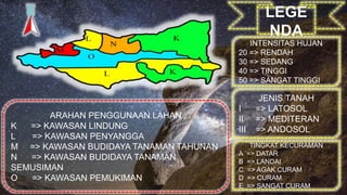
This document provides a legend or key for interpreting land use recommendations based on rainfall intensity levels, soil types, slope gradients, and designated land use directions. The legend defines numerical ranges for rainfall and slope measurements, identifies three main soil types, and assigns codes for protected, buffer, agricultural, residential, and other land use areas.


